

fountainguy97
-
Posts
1,028 -
Joined
-
Last visited
Content Type
Profiles
Blogs
Forums
American Weather
Media Demo
Store
Gallery
Posts posted by fountainguy97
-
-
36 minutes ago, calculus1 said:
I'm seeing a lot of 850mb wind images being posted. While some of those winds get mixed down to the surface, those are not the speeds we should be expecting at the 10m-level. I'm also seeing several images with no legends or titles. It's hard to tell what we're looking at in those cases. Please be specific, guys.
Except in this case they are. That's exactly what HRRR shows. 850mb winds mixing ALL the way to the surface at near 90-100% effectiveness. Hence why its required to watch the 850mb winds.
-
10 minutes ago, Lookout said:
I'd be surprised too...but as others have noted, even a conservative 10 to 20% reduction is still significant. Almost on cue, winds are increasing also in rabun county...clayton is sustained at 24g37 and tallulah is gusting to 40. Right where and when the hrrr shows it starting.
zirconia now 23 g to 44. travelers rest up to 35.
You can watch it on radar too. Seeing some 55mph on radar in that area. Slowly building just like HRRR. The rapid explosion of winds happens between 11-1pm for areas west of CLT. We will see if that verifies
-
1 minute ago, Lookout said:
HRRR gets the winds going first within the next hour and indeed we are seeing 40mph gusts now at the nc/sc border. zirconia had a 42mph gust a few minutes ago
the question is how high do the gusts go? I am highly suspicious of 80mph gusts somewhere. But I guess from a theoretical standpoint if we see 95-100% of the winds mix down its not out of the question...
-
15 minutes ago, jjwxman said:
From what I can see, and correct me if I'm wrong, The losest 100 mb on the latest HRRR sounding goes Dry Adiabatic on the backside of Michael allowing 50+ kt wind gusts to mix to the surface.
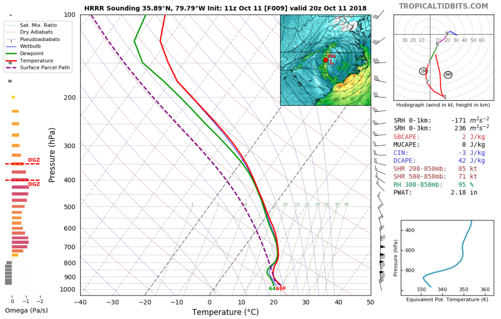
Check out this one.

-
2 minutes ago, QC_Halo said:
Is that surface winds?
gusts yes
-
4 minutes ago, jjwxman said:
From what I can see, and correct me if I'm wrong, The losest 100 mb on the latest HRRR sounding goes Dry Adiabatic on the backside of Michael allowing 50+ kt wind gusts to mix to the surface.
Seems likely. As the storm opens up and starts going extra tropical this filter dry air into the lower atmosphere. Allowing for what the HRRR shows.
The question is how efficient will it be at pulling those upper winds to the surface?
-
here is the initial explosion of winds. This has to be over done right??

Here are the peak frames:


-
 1
1
-
-
1 minute ago, PackGrad05 said:
What time is that image above valid at?
Guys this HRRR run is INSANE. winds 85+ WEST of Charlotte.
and 5pm
-
6 minutes ago, Snovary said:
Just a question how effective are the 850 winds at filtering down to the surface in a extra tropical scenario vs a normal tropical cyclone? Looking at the 10m winds it doesn't seem like many are getting to the surface. But obviously wouldn't take much.
It is the transition from tropical to extra-tropical that brings those 850's down. In certain cases it can be near 100% effective in bringing down those winds. 10m wind maps are the sustained speeds. This setup will not bring high sustained speeds. Rather it will bring very sudden and high gusts. So if HRRR is right some areas will be sustained 30-40mph winds but gusts 70-80mph. This is likely overdone.
-
1
-
 1
1
-
-
HRRR continues to strengthen the band of winds with the latest run.
This run is absolutely wild for Central NC. And honestly for the whole state.
.thumb.png.a4870348d32023bdd5b2e724561a2a98.png)
-
1
-
-
5 minutes ago, CaryWx said:
Intensifying and dropping 3 clicks to a 989? Is this really going to happen over land?
It has before but no. That is the same time each image. Its the HRRR trend not a progressive run. So instead of 991mb the HRRR shows 989 at the same hour.
-
9 minutes ago, PackGrad05 said:
I have a good idea why. Florence was being tracked and hyped in the news almost 10 days away from landfall. There was a LOT of build up leading to the storm and people were lined up at gas stations, groceries for water, etc... Michael popped up (seemingly overnight) and many people (including the news) didn't pay much attention to it since it was in the Gulf. There wasn't the same hype and buildup until 1-2 days ago... Plus, typically a storm traveling this far really doesn't give us much impact . This is a new scenario. (for most people)
Back to the meteorology: I do think the triangle will have gusty winds similar to Florence... But I'm still not sold on the gusts advertised by high res models on the backside. I definitely think we see some strong gusts as winds shift on the backside and with frontal passage, and a couple big bursts will be possible, but I don't think it will be as widespread.
Yeah its hard to believe the high res. But lets check into their verification. So far the 06z HRRR run has verified in most places with its wind gusts within 5-10mph.
Something else I have noticed in the past with the HRRR is that it usually locks in rather firmly in the 8-10 hour mark. And that normally happens by way of a big trend in the 14-8 hour range.
Here is the latest 5 runs of the HRRR:

We will see what comes of this. But that is a very obvious and large trend back to some impressive wind gusts.
-
1
-
-
32 minutes ago, a5ehren said:
FWIW, the wind maps seem to be overdone for everyone outside of the center core. I never got a TS force gust here in N ATL like the maps said, unless that is supposed to come later.
The ATL NWS obs show several 36mph+ gusts.. exactly like hrrr showed so hrrr has been verifying away from core and in every area I’ve checked within 5-10mph
-
1
-
-
3 minutes ago, olafminesaw said:
And when you get run to run consistency from the HRRR, 9 times out of ten, it is going to be approximately correct. That probably means "only" gusts in the 40-60 mph range, but it's something which we wouldn't even be considering if it weren't for hires models.
For what it’s worth the 12, 18, and 00z hrrr run have all had this type of gusts (70-80 and even 90mph on 00z) 00z being the most agrressive. You can probably shave those gusts down to 60-70 mph. As a general rule I usually reduce those gust maps a little.
Now the normal 18hr runs are getting into range.
-
5 minutes ago, downeastnc said:
yeah the 00Z HRRR has 70-90 mph gust from I 77 east...obviously overdone.....the question is by how much.....like you pointed out it would take all the stars aligning to pull that kind of wind off, but again this setup hasnt really ever happened before ( or at least not in the last 100 or so years) so maybe this is that 95th percentile event....we will know in about 15 hrs if the winds forecast start to happen out west.
Yeah very hard to say. But I’d say there is a shot at some big time gusts tmrw. This storm is on another level than normal as far as intensity. It’s very possible for some residual 80-90knt 850mb winds to filter down almost 100% when the dry air filters in.
Setup is there. But stars would have to align.
The HRRR has enhancement started 14z tmrw so 10am? That’s the time to watch for verification. That and of course current run to run trends.
-
15 minutes ago, CAD_Wedge_NC said:
That's hurricane force winds over my backyard. That can't happen .... can it?
I’d say it’s “possible” from a theoretical standpoint. But it’s probably in the 95 percentile. Would have to get near perfection out of the enhancement and dry air filtering winds down to do that... but it is possible.
-
Wow latest HRRR is a beast with the backside enhancement.

-
3 minutes ago, Orangeburgwx said:
I'm going to get hammered... Keep in mind I live in the southern CSRA
Winds could easily be even higher for you. My wind speeds were for NC. 70-80mph gusts seem possible for you.
This is not our traditional hurricane. It is not JUST speed either. The frontal enhancement as well as the intial stages of a change to cold core will make the system more efficient at bringing winds down to the surface. Most models are now really picking up on this.
-
1
-
-
3 minutes ago, tarheelwx said:
This time may be different, but the Euro grossly overestimated the winds over the Piedmont of NC. I think some TS winds are possible, but I wouldn’t take the euro wind forecast at face value.
TW
Its not just EURO. NAM, UK, CMC, even GFS all show 60mph gusts or higher.
Not to mention that Michael's current pressure is 15-20mb lower than any of those models. While that will not fully translate up to NC it could very easily be stronger than the models currently have it over NC.
-
10 minutes ago, DopplerWx said:
euro and gfs thru the end of the run are STILL ridiculously warm.
this sucks.
agreed. It sucks right now, but on the flip side our cold is bottled up right where we want it to build snow pack for a possible early start to winter.
That being said... we wont have a fall. It will probably jump straight from this pattern to a winter pattern. LOL
-
3
-
 1
1
-
-
9 hours ago, Orangeburgwx said:
However now it is trending back warmer/slightly above average
Yep! I don’t usually follow climate models just for that reason but they are comforting when supporting good winters.
All in in all this really is a winter where all the factors could line up very nicely for winter.
Solar minimum (probably a bigger deal than most make it out to be it is THE SUN after all lol)
weak nino promotes active STJ
-qbo helps promote blocking and sustained cold
All of the very early indicators that we can actually guess at this far out are not looking bad at all. In fact, this could be a fun one I just don’t like hyping myself up this early on haha
-
1
-
-
I’ll take it
CFS really trending colder for front half of winter.
Got to like the ENSO look heading into late summer. Not too mention pretty decent ice up north and a VERY slow melt season in Greenland.
that coupled with the solar min (a very significant minimum actually) gives way to some pretty epic recipes for winter.


-
5
-
-
27 minutes ago, so_whats_happening said:
Yea only reason Im not sold on moderate status is because we keep getting this to fight back with upwelling taking place on the eastern side, hence why i feel many like the idea of modoki, but we should see how things go as we move along the MJO has been getting "stuck" it seems at times causing these enhancements to occur. Ill take warm neutral to weak nino this winter tends to bring more moisture into our area (mid atlantic) for winter time and just need it to link up with some cold patterns and we are in business.
Warmth seems to be building again in the western Pac so we may have the warming from this into early winter then another maybe into end of winter early spring time?
Yeah Modoki is possible with 1.2 still well into Niña territory.
You could say a lot of our patterns have been “in a rut.” ENSO is no exception. I think we will see a lot of erratic SST jumps for the next few weeks. Once we get some movement in the MJO then we will see a more steady trend in SST.
Its really impossible to say but we should slowly, erratically work our way up to near/weak niño status. I’d expect some staying power to materialize as we get into fall to hold us in niño territory into the winter.
Most climate models show niño holding into 2019.
as far as when the surges of warming occur... your guess is as good as mine haha
-
36 minutes ago, so_whats_happening said:
Yea had a fairly decent enhanced trade wind event take place might see another burst if you will as the waters try to re-establish themselves and maybe get a move on the MJO wave. Looks like we should probably get back into motion soon and by about August start to warm things up again? Thinking weak nino the way to go with this one.
Yeah looks like trade winds will slowly relax as we get into August. I’d say by early/mid August we see a steady warming trend happen. Won’t be fast but a slow warming.
At at this point weak niño is a very solid bet. Moderate not out of the question either but not as likely.
The question isn’t really will El Niño happen it’s more of how delayed will it be. It could be mid/late August and we have a weak El Niño or very very close to it. Or it could be much later.
Either way weak/mod El Niño for 2018-19 winter is a good guess. For those of you tracking that little fact


.png.5f3ab11a0455685ffed53232d0e256cd.png)


Hurricane Michael
in Southeastern States
Posted
Its your kids. Never too cautious there.