

sussexcountyobs
-
Posts
1,277 -
Joined
-
Last visited
Content Type
Profiles
Blogs
Forums
American Weather
Media Demo
Store
Gallery
Posts posted by sussexcountyobs
-
-
Light sleet falling. 37°
-
27.9° with light snow showers. So much for the heavy snow this afternoon? Snowstorm seems like it's over here. 7.5" may be the total here.
-
7 minutes ago, psv88 said:
Would rather sunshine
Mother in law says its sunny and 80 in Palm Beach, Florida.
-
 1
1
-
-
14 minutes ago, Tatamy said:
And you were worried about getting snow yesterday up there! Models hit your area fairly well and they seem to be verifying.
That's why I always relied on you and Robbbs to cut through all the BS, and tell me what's gunna happen my way. As you guys understand, it's a whole different world here. I can't forecast. I'm just an obs guy.
-
 2
2
-
-
7 minutes ago, Tatamy said:
And you were worried about getting snow yesterday up there! Models hit your area fairly well and they seem to be verifying.
Lol! Yes you were correct like usual. Temp keeps slowly falling here. 27.2°
-
1
-
-
3 minutes ago, HeadInTheClouds said:
32 with moderate snow, eyeballing 7-8 inches OTG. Power outages all over the place.
Just measured 7 here. Temp is 27.7 with steady moderate snow falling.
-
5
-
-
6 minutes ago, NJwx85 said:
I don't know about 3" but another 1-2" is likely.

Hmmm? That map only shows another 1 inch or so in my area for the rest of the day and evening. I can confidently say that map will be a massive fail on the low side. We will get that much in the next hour to 1 1/2 hours.
-
1
-
-
Steady snow continues. Just measured 5.6"
28.4°
-
1
-
-
Moderate snow. 28.9°
Looks like at least 5-6" on unpaved surfaces. Maybe 4" on paved.
-
1
-
-
@4:40am. Light to moderate snow falling. Wind starting to get gusty. 31.8°
Eyeballing about 4" on unpaved surfaces.
-
2
-
-
Mod to heavy snow continues. About 2" new. 32.0°
-
1
-
-
Heavy snow falling. Sticking to all surfaces. Looks like about 1 inch new. 32.0°
-
1
-
-
The light rain that has been falling, is changing to wet snow. 34.4°
-
1 hour ago, sn0w said:
The winter storm warning for western passaic, orange, and putnam was just updated 10 minutes ago.
They actually upped the min totals...calling for 6-12 where the original was 4-12.
I mentioned the same, for Sussex county hours ago. Maybe the pros see what we don't?
-
NWS just threw up winter weather advisory for eastern Passaic and western Bergen counties. Up to 5-7 inches in elevations over 500 ft.
-
1
-
-
3 minutes ago, HeadInTheClouds said:
Bust potential is huge on this storm both ways. Just IMBY 12z suite has me anywhere between 3 and 18, lol. Nothing like a tight consensus 12 hours before game time. 17z hrrr has me getting 13 inches by 11z. I'm still thinking 8-10 total.
I'm in the same boat here. Just think of contractors and landscaping business owners. They don't know if they have to call in guys or not. What do you do? If you have to be prepared, but you don't want to just waste money for nothing? We are 3 hours from the Warning start time in some areas.
-
2
-
-
1 minute ago, Tatamy said:
Looks like it does.
Thanks. So it jives.
-
2 minutes ago, North and West said:

.Lol. I get your comment. But that's not me forecasting. I don't do forecasting. That is straight from the NWS.
-
1
-
-
7 minutes ago, Tatamy said:
This is their latest snow map. I am not so sure about snow amounts of 6-10” as far south as I-78 (I am assuming that refers to places west of I287). That might be a stretch. In any case the map does do a good job of matching elevated areas to increased snow amounts.
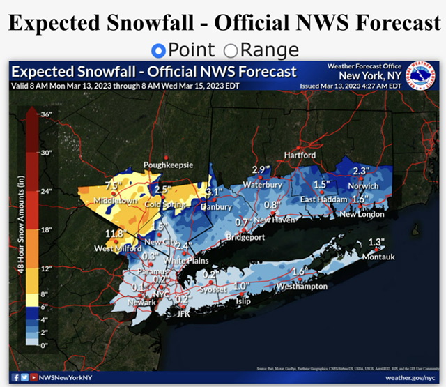
Cool. Thankyou Tat. I wonder if Upton's map matches up with that?
-
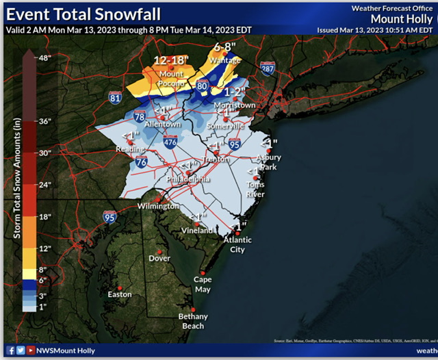
Area Forecast Discussion National Weather Service Mount Holly NJ 945 AM EDT Mon Mar 13 2023 .SYNOPSIS... A complex coastal storm will affect the area today through Tuesday night. High pressure then builds into the region Wednesday through Thursday. A cold front approaches on Friday and passes through on Saturday. High pressure returns on Sunday. && .NEAR TERM /UNTIL 7 PM THIS EVENING/... Surface low pressure off the North carolina coast this morning will slowly deepen while moving N/NE today. Rains associated with it have already overspread most of the CWA with the exception being Berks county and wrn Chester county PA. Adjustments to pops and wx have been performed for the mid- morning update. For the southern Poconos, temperatures will be colder with (near freezing this morning). These temperatures will be cold enough for snow at the onset. The highest elevations will likely receive 1-4 inches of snow by midday Monday. By this point, temps will start creeping up into the mid 30s as easterly flow brings in warmer air, and with the coverage of advisory level snow expected to be confined to the highest elevations, continued with the decision to not issue an advisory for this early portion of the event. && .SHORT TERM /7 PM THIS EVENING THROUGH WEDNESDAY NIGHT/... A strong area of low pressure will be east of the Virginia/North Carolina border this evening, as a secondary low lifts along the New Jersey shore just offshore, and this low will lift towards western Long Island by daybreak Tuesday. Most of the region will be in the warm sector for most of the rain for most of the night, though temperatures in the southern Poconos, especially in the higher elevations of Monroe county, will be cold enough to support all snow. With low pressure beginning to take on a more northeasterly track as it lifts towards western Long Island, cold air advection will develop as winds shift to the north. The rain/snow line will then spread south through the Lehigh Valley and most of northern New Jersey, mainly north of the I-78 corridor, and accumulating snow will develop during this time. Snow then continues to spread south Tuesday morning. The main question is how far south snow will get. Think there may be some light accumulating snow as far south as the Philadelphia metro area and into southern New Jersey, but really not expecting much more than an inch or so from around I-195 south. The primary low over the western Atlantic will lift towards eastern New England Tuesday morning, and then this low will merge with the aforementioned secondary low. Precip continues to wrap around this system into the southern Poconos and northern New Jersey into Tuesday afternoon before ending Tuesday evening. Strong shortwave energy will pass through the region Tuesday night, keeping light accumulating snow, mainly over the northern zones. In terms of snow totals, generally expecting 1 to 2 feet of snow across Carbon, Monroe, and Sussex (NJ) counties, though the highest snow amounts will be in the higher elevations, and most areas will pick up about 1 foot or so from tonight through Tuesday. From 6 to 10 inches of snow is possible down to the I-78 corridor, mainly from early Tuesday morning through Tuesday. Will go ahead and convert the Winter Storm Watch to a Winter Storm Warning for Carbon, Monroe, and Sussex (NJ) counties, and will also go ahead and add Warren and Morris counties, as the heavier bands of accumulating snow look to spread a bit farther south. The heaviest snow in Morris county will be in the western half of the county, and snow amounts may be minimal across the eastern half of Morris county. For now, do not think Winter Weather Advisories are needed elsewhere. A tight pressure gradient develops over the area between the low and high pressure building in from the west on Tuesday and Tuesday night. However, latest runs of the models seem to have the low a touch farther east, so the gradient is not quite as strong as it looked in prior runs. As a result, expecting northwest winds 20 to 30 mph with 35 to 45 mph gusts, which are just below Wind Advisory criteria. Although a Wind Advisory may end up being needed for the coastal strips, will hold off one one with this package.
-
3 minutes ago, Winterweatherlover said:
I think NW NJ too far SW to get into the really good stuff but if you have elevation you may do ok.
I'm thoroughly confused at this point? My elevation is 1,200 ft. We still have full snow cover from Friday night's snow.
-
Detailed Forecast
This Afternoon
Rain. High near 39. East wind 10 to 15 mph. Chance of precipitation is 100%. New precipitation amounts between a tenth and quarter of an inch possible.
Tonight
Rain before 11pm, then rain and snow between 11pm and 2am, then snow after 2am. The snow could be heavy at times. Low around 31. East wind 10 to 15 mph becoming north after midnight. Chance of precipitation is 100%. New snow accumulation of 4 to 8 inches possible.
Tuesday
Snow. The snow could be heavy at times. High near 34. Breezy, with a northwest wind 20 to 25 mph. Chance of precipitation is 100%. New snow accumulation of 6 to 10 inches possible.
Tuesday Night
Snow likely, mainly before 8pm. Mostly cloudy, with a low around 28. Blustery, with a northwest wind around 25 mph. Chance of precipitation is 60%. New snow accumulation of 1 to 2 inches possible.
Don't know what the NWS is seeing? This is my updated forecast. They actually upped snow totals to 11-20"
-
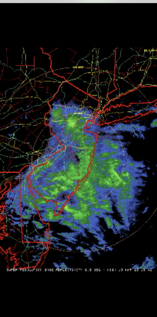
3 minutes ago, Tatamy said:
This is a screenshot of the IVT currently positioned over central NJ. Precip amounts in that area near Bridgewater are over 0.20” in places.
We've had light snow all morning that hasn't stuck since the sun came up. Now as that precip move north towards me, it has changed to rain. NWS still sticking with Warning here for 6-12" with higher amounts in higher elevations. After reading all these comments, I'm confused? Don't know what to expect. You think my elevation will save the day here?
-
Light snow falling here. Not sticking. Temp 33.0
Was just down at the Shoprite in Franklin. It was raining there, and they had no snow cover unlike at my house.
-
1
-
March 2023
in New York City Metro
Posted
Woke up to 3/4" of snow on everything but paved surfaces. 23°