

beavis1729
-
Posts
2,487 -
Joined
-
Last visited
Content Type
Profiles
Blogs
Forums
American Weather
Media Demo
Store
Gallery
Posts posted by beavis1729
-
-
On 3/1/2025 at 10:12 AM, raindancewx said:
Good to see my analog method still works. I wasn't crazy for thinking the past winter would be like 2013-14.
I never showed my forecast here, but the idea was essentially a bunch of years with alternating waves of expansive record warmth, brief record cold, and more concentrated modest cold. So I expected the 2013-14 aspect of the pattern to persist with less consistency and severity but I expected that was the closest analog overall. Locally I forecast three weeks of severe cold and ten weeks of near-record to record warmth which worked pretty well.
I know analogs aren't going to be relevant at every single location in the lower 48...but 2013-14 was one of the harshest winters on record in parts of the Midwest with respect to both cold and snow, and 2024-25 was one of the least harsh and most boring & uneventful winters that I can remember in my lifetime (I've lived in northern IL for 45 years)...at least when using snow depth days (SDDs) as a metric.
In terms of sensible outcomes and "feel", the two winters were literally as opposite from each other as possible. It wasn't even close. One example of this is that Chicago and Detroit had near record snowfall in 2013-14, while Moline IL (not very far away from Chicago) just had their least snowy winter on record in 2024-25. While there were definitely some cold outbreaks this past winter, the severity was unfortunately mitigated in may areas due to lack of snow cover over a large swath of real estate. With decent snow cover, this past winter could have been a memorably cold winter here...but instead it was just "meh".
None of this is meant to be a knock on your post/conclusions. I'm just suggesting that, for a winter weather lover, it all comes down to sensible weather/feel and IMBY outcomes.
-
 3
3
-
-
11 hours ago, tamarack said:
1983-84 in Fort Kent had 'only' 171" but the pack depth and SWE were enormous. Total precip Nov-Mar was over 25" and most was frozen. A significant IP/ZR event in mid-Dec produced a 3" crust (1.9" water) that would carry a bull moose. The 18.5" surprise (forecast was 1-3) in early Feb had the pack at 61" on the morning of 2/6 but 4 days of 25° AN chopped it to 37" by 2/16. On March 14-15 we had 26.5" that pushed the depth to 65" - 80" in the northern tip of Maine - with 16" SWE at home and probably near 20" on Big Twenty Twp. (Both that storm and that pack are the tallest I've experienced.) Then April was dry with many warm days after frosty nights, and all that water made it safely down the St. John.
That’s an incredible amount of QPF for a northern location during the cold season. Crazy to have a 5’ depth drop to 3’, then back up to 5’ during the same season.
I’m guessing 4.5+ months of continuous snow cover that winter, including 3-4 months of foot+?
Hopefully there will be another winter like that up there soon. It seems like an impossible distant memory, the way things have gone recently.1983-84 was a decent winter in the Chicago area, relatively speaking. I was 9 years old, and it’s the first winter I actually remember. Christmas Eve 1983 had the coldest daily average temperature on record, -11/-25 at ORD and a bit colder in the suburbs. 1/30/2019 came close, -10/-23 at ORD.
-
1
-
-
6 hours ago, tamarack said:
186.7" total for 76-77 with peak depth 54". We had no rain between 12/7 and 3/13, only snow, and had flakes on 82 of 90 days in DJF. After the mid-March thaw settled the pack by 20"+ and cold returned, the snow was so solid that we had 3-4 weeks of no-snowshoe travel thru the woods (would support a running moose), where the depth was 3-4 feet. We spent Christmas with family in NNJ while Fort Kent had 24" on 12/26-27, then another 12" that we drove thru during the night of 29-30 (another story). Our 2nd car, a blue VW Beetle, was just a white lump in the parking lot when we got home.
That’s incredible…definitely a legendary winter of yore.
-
On 3/6/2025 at 10:09 AM, tamarack said:
Up here on the "fringe" it was 15+ hours of steady moderate snow for 9.5". The post-equinox dumps of 16" and 19" made March 2001 the 2nd snowiest month (55.5") I've seen. Only the 61.5" of Dec 1976 at Fort Kent had more.
Wow…I imagine your snowpack lasted forever that season, even if much of the rest of that winter was dry (?).
One of the all-time cold winters up there, right?
-
It dropped to -45F in Hettinger ND, under perfect radiational cooling conditions. This is incredible, considering that it's relatively late in the season. Probably around 50 degrees below normal (?).
Weather observations for the past three days forHettinger, Hettinger Municipal AirportImperial (Metric) Date Time (mst) Wind (mph) Vis. (mi.) Weather Sky Cond. Temperature (ºF) Relative Humidity Wind Chill (°F) Heat Index (°F) Pressure Precipitation (in) Air Dwpt 6 hour altimeter (in) sea level (mb) 1 hr 3 hr 6 hr Max. Min. 19 07:53 Calm 10.00 Fair CLR -38.2 0 0% 30.63 1049.3 19 06:53 Calm 10.00 Fair CLR -41.8 0 0% 30.63 1049.2 19 05:53 Calm 10.00 Fair CLR -43.6 0 0% 30.63 1049.3 19 04:53 Calm 10.00 Fair CLR -41.8 0 -36 -45 0% 30.65 1049.5 19 03:53 Calm 10.00 Fair CLR -43.6 0 0% 30.66 1049.8 19 02:53 Calm 10.00 Fair CLR -38.2 0 0% 30.67 1049.5 19 01:53 Calm 10.00 Fair CLR -41.8 0 0% 30.68 1050.3 19 00:53 Calm 10.00 Fair CLR -38.2 0 0% 30.68 1050.2 18 23:53 Calm 10.00 Fair CLR -40 0 0% 30.68 1050.4 -
1
-
-
An intense arctic airmass is in place across ND and eastern MT. This would be very impressive in mid-winter, but even more so on Feb 17-19. Coldest since early Feb 1996?
Here's the NWS forecast for Crosby, ND in the far NW corner of the state. Temps were in the minus 20s at midnight, so the daily max may end up around -20. That is incredibly rare.
Washington's BirthdaySunny and cold, with a steady temperature around -20. Wind chill values as low as -40. North wind 3 to 8 mph.TonightPartly cloudy, with a low around -45. North wind around 5 mph becoming calm in the evening.TuesdaySunny and cold, with a high near -14. Wind chill values as low as -45. Calm wind becoming north around 5 mph.Tuesday NightMostly clear, with a low around -43. Wind chill values as low as -60. Light and variable wind becoming northwest around 5 mph in the evening.WednesdaySunny and cold, with a high near -5. Southwest wind 5 to 7 mph becoming southeast in the afternoon.Wednesday NightClear, with a low around -26. South wind 6 to 10 mph.-
1
-
-
6 hours ago, RCNYILWX said:
Some hindsight involved here, but I think the average of the ensemble 10:1 mean, probability and percentile stuff told a pretty consistent story. From the NWS perspective, I haven't been directly involved in the forecast process this time, but the inter-office collab and collab with WPC aspect is way more challenging than many realize. Internally, we felt that the QPF and ratios were too aggressive but there's only so much we can do when trying to form a consistent picture across large regions.
To me this looked like a advisory to perhaps low end warning event, particularly on the non-GFS/GEFS data. It's easy to get caught up in the Kuchera ratio output when assessing the snowfall forecast, that method is too simplistic though. 10:1 gets bashed, and it should in marginal temp situations and more clear cut high ratio setups, but I think it's a good first guess plenty of the time for synoptic systems.
Use the 10:1 and then adjust up where you're confident better banding is going to set up, through using model diagnostics like f-gen and cross sections, and utilizing the Cobb output.
Sent from my Pixel 9 Pro using Tapatalk
With complete respect, I don’t think this is accurate. Most guidance was hinting at around 0.4” of QPF 36 hours ago with ratios around 15:1, generally leading to 5-8” of snow. Some were showing even more, but I agree with not giving them much weight.
Now it’s looking like 0.25” of QPF with 12:1 ratios, around 3” of snow.
That’s a huge difference.
It’s frustrating that a million things need to come together to get a proper snowfall around here. What happened to clippers?
-
1
-
-
10 minutes ago, hawkeye_wx said:
My 7" actually makes me one of Iowa's winners this winter. There are still a few spots in sw Iowa that have received ZERO measurable snow. That's nuts.
I think Mason City only has 2.7” on the season, which is arguably even more shocking than the SW Iowa stat since Mason City is near the MN border.
-
37 minutes ago, Chicago Storm said:
guy…
you really need to get over it. our climo is what it is. you can’t just come up with this idea that it should be magically better just because you want it to be. as many of us have said, you live in the wrong place for what you’re looking for.
either you can’t quite grasp the reality of things or you’re one of the best trolls we’ve seen.Ha ha...I wish this were true.
-
 1
1
-
-
6 minutes ago, michsnowfreak said:
First of all. Observations were very reliable. If anything they were more detailed than we get today. Everything was manual, now snow is the only thing manual (outside of necessary fixes to the wx observing equipment). The mid century time frame was one of the worst for snowstorms here. We did have a few good ice storms. And second of all. You love to use the coldest normals in Chicago's entire climate record as your norm, but yet it's not fair for us to acknowledge how good the last few decades have been for snowstorms?
I don't understand why you keep arguing about this - we're on the same side. Can't you admit that our climo is horrible, if you're a person (like yourself) who likes snow...and especially snow cover? Just because it has been relatively better in recent decades, doesn't mean it's good. Why is this so difficult for people to grasp? Every winter in Miami gets an F; it's the same concept. In my mind, the last 10 winters have been horrible, because there have been way too many thaws. Doesn't mean that snowfall itself has been horrible, but as everyone knows that's only one aspect to winter.
2013-14 and 2014-15 were the last good winters, and all I keep hearing about is how great they were and that we should never ever complain again...and how we should just be content with the current winter that hasn't had more than a 1" depth all season. Those good winters were 10 years ago...are we going to keep falling back on the nostalgia of them forever and ever?
-
3
-
 2
2
-
 1
1
-
 1
1
-
-
33 minutes ago, michsnowfreak said:
The most consecutive winters withOUT a 6"+ storm was 6, from 1944-45 thru 1949-50.
The most consecutive winters with at least one 6"+ storm was 14, from 1890-91 thru 1903-04
The decade with the least 6"+ storms on record was the 1940s, when just one storm of 6"+ fell
The decade with the most 6"+ storms on record was the 2010s, when 19 storms saw 6"+
Despite not having a 6"+ storm since March 3, 2023, we have already seen 6 in the 2020s.
I have to believe that the observations back then weren't very reliable. How could Detroit only have one 6"+ storm over a 10-year period? If that's actually correct, all it does is illustrate (yet again) how horrible our winter climo is. It shouldn't make any of us think "oh, we've been lucky in recent decades"; it's just not a reasonable reaction/response. If a student scores 20% on an exam after getting a 0% on a previous one, the 20% score is still an F.
-
1
-
 1
1
-
1
-
-
On 1/31/2025 at 8:13 AM, buckeye said:
have another drink....
Jan 2025 wasn't really that cold in Chicago, with a monthly average of 22F. The shame is that it could have been a Top 20 cold month if there was snow cover here and upstream. That's the bigger story.
If you look at 1951-1980 normals, Jan 2025 was actually a +1F departure...even as it was -3F vs. 1991-2020 normals. That says more about the obnoxious warming (exacerbated by UHI) over the past 40 years than anything else.
-
On 1/31/2025 at 6:15 PM, cyclone77 said:
6 years ago today MLI hit -33 for a new all-time record low. Hit -27 here that morning.
Interestingly, today is also the day we hit 69 degrees back in 1989 for the all-time warmest January temp. I still remember that day, as I played hooky from middle school that day lol.
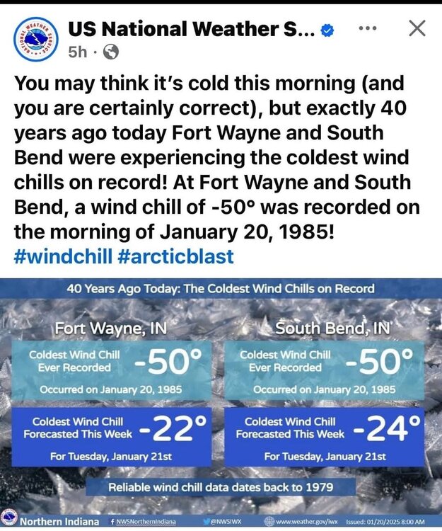
The craziest warm/cold temp swing over a short period in Chicago was probably in the 1984-85 winter. It was 69F on 12/28/84, then -27F (all-time record low) 3 weeks later on 1/20/85.
-
2 hours ago, powderfreak said:
Yeah, like that guy in the ski thread who vacationed there recent at one of Alex’s properties and said they woke up every morning to the car covered in fresh snow.
It has been amazing to me the lack of synoptic snowfall or even precip events. It hasn’t rained or snowed synoptically in a long time.
I guess tomorrow is synoptic but there’s an orographic assist too. Been a while since just straight mid-level lift producing precip.
For sure…and it has been just as bad in the Midwest.
Here are a couple examples of places that have essentially experienced a snowless winter so far. Data since November 20th, which I consider to be the beginning of winter:
- Mason City IA: 1.14” precip (most fell on one mild day in December), 2.7” snow
- Omaha, NE: 0.85” precip (most fell on one mild day in December), 1.0” snow
It would be nice if we could ever experience a proper winter. The last one was 2014-15. I know it has been similar in much of SNE. It just gets to be ridiculous at some point.
-
1
-
-
6 minutes ago, OrdIowPitMsp said:
46 currently. Record is 47, top shelf late January day for Minnesota.
With not much snow on the ground I’ll take these warm days if it’s going to be dry.
It's bad enough this winter in MSP...but I just saw that Mason City IA has 2.7" of snow for the entire season, and Omaha NE has 1.0". There aren't really enough words in the English language to describe how bad this is.
Even worse, it applies to a wide swath of geography across the lower 48...basically coast-to-coast north of 40N outside of the lake belts.
-
8 minutes ago, Torch Tiger said:
at least we share an absolutely shit disaster winter with Anchorage AK
Yeah...and the Midwest & northern Plains. Shockingly low snowfall (and even worse on the SDD front) in so many areas so far this season.
Anchorage has only had 4.1" of snow since Nov 17th, with an approx +12F departure over that period.
-
2
-
-
6 hours ago, nrgjeff said:
I used to live on the southeast corner of the US-59 and I-610 interchange, some apartments tucked in there. That building was out my window from the other direction. Never imagined I'd see something like this!
How about 27 deg. SN+ at Hobby! That's not Southern slush. That's Midwest powder, and a lot of it!
25F with SN+ at Pensacola NAS, right on the Gulf, in the middle of the afternoon:
Location Time
(cst)Sky/Weather Temp.
(ºF)Dewpt.
(ºF)Humidity
(%)Wind
(mph)Pressure
(in)Click on location name for the weather during the past two days at that site. Pensacola - Pensacola International Airport 14:53 Snow 24 19 81 N 14 G 23 30.41 Birmingham, Birmingham International Airport 14:53 Overcast 25 3 39 N 9 30.52 Crestview, Sikes Airport 14:53 Snow Freezing Fog 24 22 91 N 8 G 22 30.45 Destin, Destin-Ft. Walton Beach Airport 14:53 Light Snow 30 25 82 N 16 G 25 30.42 Evergreen, Middleton Field 14:53 Snow Freezing Fog 23 20 88 N 7 30.44 Keesler Air Force Base / Biloxi 14:55 Light Snow Fog/Mist 25 21 85 N 12 30.46 Milton - Whiting Field Naval Air Station North 14:56 Snow Freezing Fog 23 22 96 N 5 30.42 Mobile, Mobile Downtown Airport 14:53 Snow 25 19 78 N 14 30.49 Montgomery, Dannelly Field 14:53 Overcast 25 20 81 N 8 30.49 Panama City - Northwest Florida Beaches International Airport 14:53 Overcast 32 23 69 NW 16 30.37 Pensacola Naval Air Station 13:55 Heavy Snow 25 23 92 N 10 G 24 30.42 -
1
-
-
12 minutes ago, Frog Town said:
Assuming this takes into account the change in the wind chill scale.
Yes, it does. The WC at ORD that morning was -57F on the new scale (-27F temp with 20 mph winds). It was in the -70s on the old scale.
-
32 minutes ago, RCNYILWX said:
Agree, really impressive airmass. The most intense cold with no snowpack in quite some time. For Chicago, have to go back to Feb 4-5, 2007 for a comparable event. Rockford had snow otg in that stretch, so it's been even longer there. Would've been interesting to see how close this got to the end of January 2019 with a solid snowpack in place.
Edit: Rockford, at -11, at least tied 1/17/1954 for the coldest temp without snow cover since 1951.What's even more impressive about this airmass (although I'd prefer to say "maddeningly annoying and frustrating") is that there's bare ground for an entire 200+ mile radius around MBY, and we still hit -10 this morning. There's no snow cover upstream anywhere south of 45N, and even where there's snow cover north of that it's not very deep/widespread.
Usually when you get cold with no snow cover, the snow field is at least very close...which limits the temp moderation somewhat. In this current situation, we didn't really have that.
This would have absolutely challenged January 2019 in many areas, imo. A good illustration is Orr, MN where it was -18/-36 yesterday with only 9" of snow on the ground. On Jan 30-31 2019, it was -22/-35 and -18/-42 with 14" of snow on the ground. So, while the temps were slightly milder yesterday vs. Jan 2019, there was a bit less snow cover.
-
1
-
-
5 hours ago, Brian D said:
Significant low max's yesterday.
I-Falls -12 (4th), Hibbing -10 (T2nd), Duluth -8 (T4th), Brainerd -7 (3rd), Park Rapids -10 (T4th), Ashland, WI -3 (2nd), Eau Claire, WI -4 (T3rd).
Just to show what this airmass was capable of…it looks like Ely MN will post a -17/-36 today, for a daily average of -26.5. This may be a Top 10 all-time coldest day on record there.
The max of -17 is even more impressive. While the -36 min would be great to experience, I imagine Ely hits -40 every 3-5 years (?) on average.
I was in Grand Marais MN over the 4th of July this year. A beautiful area, and a nice cool breeze during the summer.
-
3
-
-
16 minutes ago, roardog said:
Yeah. We haven’t seen this type of pattern in a long time. It seems like we’ve had some semblance of a -PNA and SE ridge for a decade. It’s boring but at least it’s different I guess.
I suppose…but you’re making it seem like this type of pattern happens occasionally, and that it’s ok. Another example of our standards being beaten into oblivion after 8 years of bad winters. It shouldn’t be that way. It’s fine to have a 2-3 week period of cold and dry at some point in the winter, but that’s why you need to build a snowpack earlier in the winter. Then at least it would look like winter (and maximize the cold) if a cold and dry period occurs.
We shouldn’t be normalizing bare ground in most of WI, MN, ND, SD, and IL in mid-January.
-
1
-
 1
1
-
-
3 hours ago, Brian D said:
Extreme cold warning in effect starting later this evening thru Tues am. Wind chills down to -45 or so on NW winds. Midnight high of 16 with temps hovering around 0-5 for the aftrn high here in town before the drop continues. Inland areas should stay just below zero for the aftrn.
Congratulations - enjoy!


-
1
-
-
There are no words to describe how frustrating this is. It could have been a Top 10 arctic outbreak for our area, if there were snow cover here and upstream.
The dump of arctic air will be in full swing Sunday night with a
lobe of roughly -27 to -30 C 850 mb air waiting in the wings just
to our north and west, and this will traverse northern Illinois
fully on Monday night. From a climatology perspective, this is
just about as cold as we`ve seen (at 850 mb) in the nearby upper
air database (Quad Cities and Lincoln, IL). Out of curiosity, went
back and took a look at the arctic outbreak from this time last
year (January 14 - 17), which featured low temperatures in the -5
to -15 degree range and wind chills solidly down towards -30 F
(and even lower than that on short time periods). 850 mb
temperatures last year were actually notably warmer,
generally around -20 C. They key difference was a widespread
and dense snowpack which we obviously don`t have this time
around, which just goes to show the power of snowpacks in
altering these arctic airmasses.
-
1
-
-
1 hour ago, roardog said:
There’s a difference between a winter that’s been too warm to keep a snowpack and one that’s not. Yes, it’s been a dry winter all over the Midwest. Northern Wisconsin might not have much snow cover right now but at least it’s been cold enough to freeze up the lakes for activities like ice fishing which is still a big part of the economy in those areas. That’s the big difference between this winter and last winter. Snow cover in non lake effect areas will always be hit and miss. 2 years ago Minnesota was getting buried with snow and had plenty of cold too so not everywhere had a “bad” winter 2 years ago.
Right, I hear you...but that assumes you have a snowpack to begin with. Considering it's mid-January, way too much of the Midwest doesn't (southern half of MN and southern 3/4 of WI, for starters).
-
1
-
Late June 2025 Heat Wave
in Lakes/Ohio Valley
Posted
This is the earliest 80+ min on record for Chicago. Previous earliest was 6/28/1913 (min was 81 on that date).