Jump to content

heavy_wx

Meteorologist
  • Posts

    1,619
  • Joined

  • Last visited

Everything posted by heavy_wx

  1. Getting bigger aggregates now, corresponding to increased reflectivity and reduced ZDR.
  2. Measured about 5" on the ground with light snow in North Laurel.
  3. Confirmed clumps of dendrites/planar crystals falling within the band of higher reflectivity here. Maybe 1-2" on the ground so far.
  4. Yeah, hopefully it will be a good storm for us down here (my first). It will certainly be interesting to see how the banding sets up.
  5. Just for fun, here is a good example of mesoscale banding indicated by some diagnostics of the 12z NAM. The 750 mb heights (black), frontogenesis, and saturation equivalent potential vorticity (SEPV) are plotted above. SEPV is a measure of the stability of air parcels to slantwise and/or vertical displacements in a saturated environment. Regions of negative SEPV have been associated with mesoscale precipitation bands in winter storms. You can see that there is a band of negative SEPV from east of the Delmarva to northern MD, to the north of the closed 750-mb height contour. There is also enhanced 750-mb frontogenesis in this region, associated with a thermally direct circulation (i.e., warm air rising to the south, cold air sinking north). This circulation provides lift, and in the aforementioned environment of conditional stability, leads to enhanced vertical motion within the general synoptic ascent. An important thing to note with these diagonistics is that these circulations and regions of conditional instability occur within layers of the atmosphere, and are often sloped. For example, here is the same plot but for 850 mb: You can see here that the main region of conditional instability and enhanced frontogenesis is displaced to the south over central VA and SE MD. These two levels are different horizontal slices through the same circulation; in this case the circulation is sloped to the north with height. Where this circulation intersects the dendritic growth zone (DGZ) is often where the most intense banded precipitation occurs, due to the region having the most efficient ice crystal growth and aggregation. For more information, this is one good resource: http://cstar.cestm.albany.edu/CAP_Projects/Project6/Mesoscale_Structure/seminar (M. Greenstein).ppt
  6. Yeah, I was kind of planning on doing that beforehand anyway just because I had a long drive back. I probably would have stayed around a bit longer otherwise.
  7. I left maybe 10 minutes after totality. Traffic was fine on I-40 east until I got to the exit ramp. All of the local roads from Tennessee into Kentucky towards I-75 were bad, and it ended up being a 5-hour drive to I-75 that takes under 3 hours without traffic. After a few miles on I-75 traffic was fine and opened up a lot once I got to I-64 east in Kentucky. That part of the trip was definitely helped by the lower populations of West Virginia, western MD, and central PA.
  8. I ended up witnessing the total eclipse at Edgar Evins state park 60 miles east of Nashville. The build-up to totality was amazing; it got noticeably colder and the cumulus died as if an outflow boundary had swept through the area. The light got noticeably dimmer, and it kind of looked like those scenes in old movies where they film shots in the day and darken them to make it seem like night. Totality itself was of course awesome; light from the corona seemed to extend away from the sun in a wishbone shape, with one wispy strand of light to the left and two strands to the right. We were also able to see Venus, and I think Mercury during totality. My favorite picture of the event (the only one I took during totality):
  9. Got to my hotel in Richmond, KY. Very light traffic from PA through MD, WV, and KY. I'll probably head south for central TN around 5 am, and hopefully there won't be much traffic at that time.
  10. Watertown is about 3 hours from Scranton. But maybe it's a bit early to plan lol.
  11. The best bet might be the cumulus shadows near the Ontario and Erie lake shores. Of course in April, there could also be widespread overcast throughout the Great Lakes.
  12. Same, I've never been to Kentucky or Tennessee. I'm thinking I'll probably leave my hotel in KY around 4-5 am just to be safe with regards to traffic. I have plenty of work to keep me busy while I wait anyway...
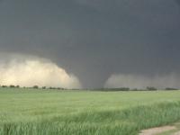
  13. Some supersaturation wrt ice around 200 mb but otherwise southeastern TN is looking pretty good as of now.
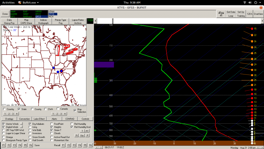
  14. I think it's probably best to be at your intended viewing location at least a couple hours before the eclipse. I would definitely avoid big metro areas like St. Louis or Nashville if possible. Major interstates near the path of totality will probably be OK a few hours before the eclipse. Interstates that connect directly to large cities like I-55 and I-70 in Illinois, I-65 in IN/KY, and I-75 in KY may be pretty busy early in the day if people are driving south for the day. I'm considering going to Sparta, TN because it isn't near any north-south interstates and it's also not really that close to I-40, so traffic shouldn't be bad a few hours before the eclipse.
  15. It's only like an extra second longer in southern IL vs. central MO so I'm not sure that will really cause people to seek out that area especially; weather and convenience are probably the dominant factors in where people end up going. Getting to the center of the totality path is also important if you want a longer eclipse. I booked a hotel in Richmond, KY for Sunday night with plans to drive into central TN or western KY depending on the weather.
×
×
  • Create New...