

SR Airglow
-
Posts
4,026 -
Joined
-
Last visited
Content Type
Profiles
Blogs
Forums
American Weather
Media Demo
Store
Gallery
Posts posted by SR Airglow
-
-
30 minutes ago, powderfreak said:
This is obscene... over a foot of paste. There is so much snow at the ski resort. What a month.
And it's just nuking. With upslope coming.
Unreal for February, forget November. Making tracks to Sugarbush tomorrow unless K somehow beats them overnight.
-
Steady snow in Copley.
-
I'd support a January gtg; I'm usually traveling mid December to just after the new year and haven't been able to make one yet unfortunately (and this year will likely be no different, slim chance I could make the 14th but not likely). Would love to get to meet some of the group.
On 11/17/2018 at 9:39 AM, CoastalWx said:Could do earlier or later I suppose. Or just scrap it for a larger gtg in Jan? I guess I’m just trying to look at it from a turnout perspective.
-
4” ish at Killington but the wind is making it really hard to get an accurate measurement. Stoked for tomorrow!
-
Eyeballing 2” in Woodstock, VT; going back and forth between smaller flakes and fluffy dendrites. Almost there!
-
6 minutes ago, The 4 Seasons said:
Anyone with final totals in CT PM me or tag me and ill try to get a map at ASAP.
Lots of reports on our page, accuracy is all over the place but if you’ve got a specific area that you’re looking for it’s worth looking. 9” in New Milford is the highest I’ve seen come into us so far.
-
SN on I89 near Grantham NH, kudos to the NHDOT crews who are keeping things relatively decent so far. Noticeable improvement when we crossed the border from MA to NH although MA was alright as well given the circumstances. Gonna be a pow day at Killington tomorrow!
-
Accumulating quickly on all surfaces despite light rates - good sign I'd say for us city folk. Heading north shortly but rooting for a nice positive bust for you guys!
-
Light snow has begun.
-
7 minutes ago, sbos_wx said:
I'm around 34/35
Still 31 here on the hill. Guessing there's going to be a pretty sharp line between a coating and 3-4"; whether that sets up in your area, my area, or out in Brookline/Newton is still up for debate I think.
-
Salting truck just came down my street so they're out in the city now, guess they saw what happened in NYC and don't want to meet a similar fate. I'm heading north to Killington in about an hour, expecting a long slow ride but hoping that NH/VT have 93/89 relatively okay and that we're able to stay on the leading edge of the system.
31/24.
-
1 minute ago, CoastalWx said:
That increase isn’t the issue. I can see doing that like many did today, but by a small amount. But they were way too low near HVN all along.
Yeah. I was more referring to what I called them out on this morning, but they were very conservative to start with (which is generally how they work - they're either super conservative or super bullish depending on who is on the desk).
-
8 minutes ago, CoastalWx said:
They had like 1-2 for hvn through last night. Terrible.
Well yeah, but many of us (myself included) thought their 6-8" this morning was just as terrible. I don't mind being proven wrong though when it's a positive bust.
6 minutes ago, OceanStWx said:1" at EWR at 630 this morning.

Yeah that one's pretty bad.
-
Kudos to OKX - they made a bold call and it worked out for them. Getting lots of 4" reports already on the coastline (Fairfield and Darien both south of 95).
-
4 minutes ago, BrianW said:
Just posted on social media.

I think that deserves a
 or two for southern CT. I really don't see the model support for widespread 6-8" - sure could see a lolly or two but there just isn't enough time before the midlevels warm.
-
If you had to make a call vs skiing Loon (Lincoln, NH) or Sunday River (Bethel, ME) tomorrow, which one would you choose? I'm thinking SR might have a better chance of getting into some of the mesoscale stuff but maybe Loon's going to do better on the WAA?
-
2 minutes ago, ORH_wxman said:
Jerry, latest RPM:
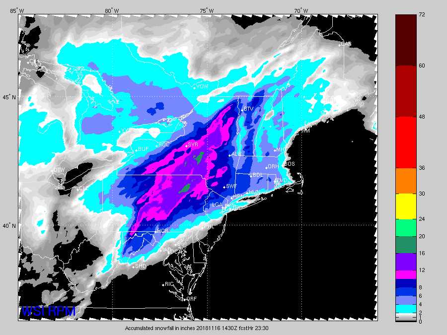
Does that cut off at 23:30 tonight or tomorrow? Seems really light for NNE.
Think the warnings from BOX are aggressive but I can see where they're coming from with it being the first event of the season and bad timing. I really like the map that @WxWatcher007 put out for us this morning for CT, otherwise take a consensus blend and throw out the op GFS and I think we're in a good place. Seems like the consensus for a general 4-8" for interior SNE and all of NNE is solid. I'll go 1.5" at Logan and 3" here (Mission Hill, about 4 miles inland).
-
1 hour ago, mahk_webstah said:
I think they overreacted, and we end up with mostly snow and 6", which is close to warning. It may the weirdly worded zones that mention sleet and freezing drizzle at various times, like ("snow before 3am, then sleet between 3-4, then snow, then freezing drizzle from 6-7...etc.)
I would agree. They've got rain in the grids as far north as Lincoln, which I find hard to believe given what we're seeing on the guidance. I'm guessing they're weighting the GFS somewhat which is by far the lowest model on QPF. I'd still be confident in 6" ish for you and points north basically, although the concern for some of the valleys up north would be shadowing killing precip rates after the initial thump - some of the models have almost nothing up there tomorrow morning after the initial snows tomorrow night.
-
11 minutes ago, TauntonBlizzard2013 said:
Has this sped up some? Looks like flakes could be flying by later afternoon Thursday
Yeah - has shifted from largely post PM commute to coming down hardest during rush hour for a lot of CT. Could be a nasty surprise for many.
-
2” of slop in Shelburne, 4-6” on the mountain with light rain right now. Was hoping for a bit more but hey it’s whitened everything up and it looks beautiful.
-
1 minute ago, powderfreak said:
The HRRR didn't have the valley snowing till like 8pm tonight.
Nice to see the two ASOS of MVL and MPV reporting snow.
MPV a bit higher up is 32/32. Could be a nice pasting for someone tonight.
And that's been on the more aggressive side of guidance too when it comes to cold and snow with this one. Somewhere like Alex's spot could see double digits if it keeps progressing like this I'd think.
-
1 minute ago, powderfreak said:
And just on cue with the heavier snow at home, the MVL ASOS at 730ft just went over to 33/33 snow.
Crazy wet-bulb processes.
If you're snowing well at 730' in VT I'd think there and up in NH and ME are in for a good night.
-
2 hours ago, dendrite said:
No idea. I had the trial when he started up last year. I'm on the fence with who to go with. Who has more EPS/seasonal maps? Does wxbell have the off-hour EC?
No off-hour EC on WxBell. Never used Maue's new site so don't know what to compare it to, but I've generally been happy with the EPS and other Euro products on WxBell.
-
48 minutes ago, powderfreak said:
Things very few on here care about, but the meso-models are surprisingly cold tomorrow evening for the Adirondacks, Greens, Whites, etc. RGEM and NAM even want to snow into the NNE valleys for a good burst of QPF on the front end. 850s are surprisingly cold too.
If something like the NAM/WRF/RGEM panned out, could be more interesting than it seemed a day or two ago.
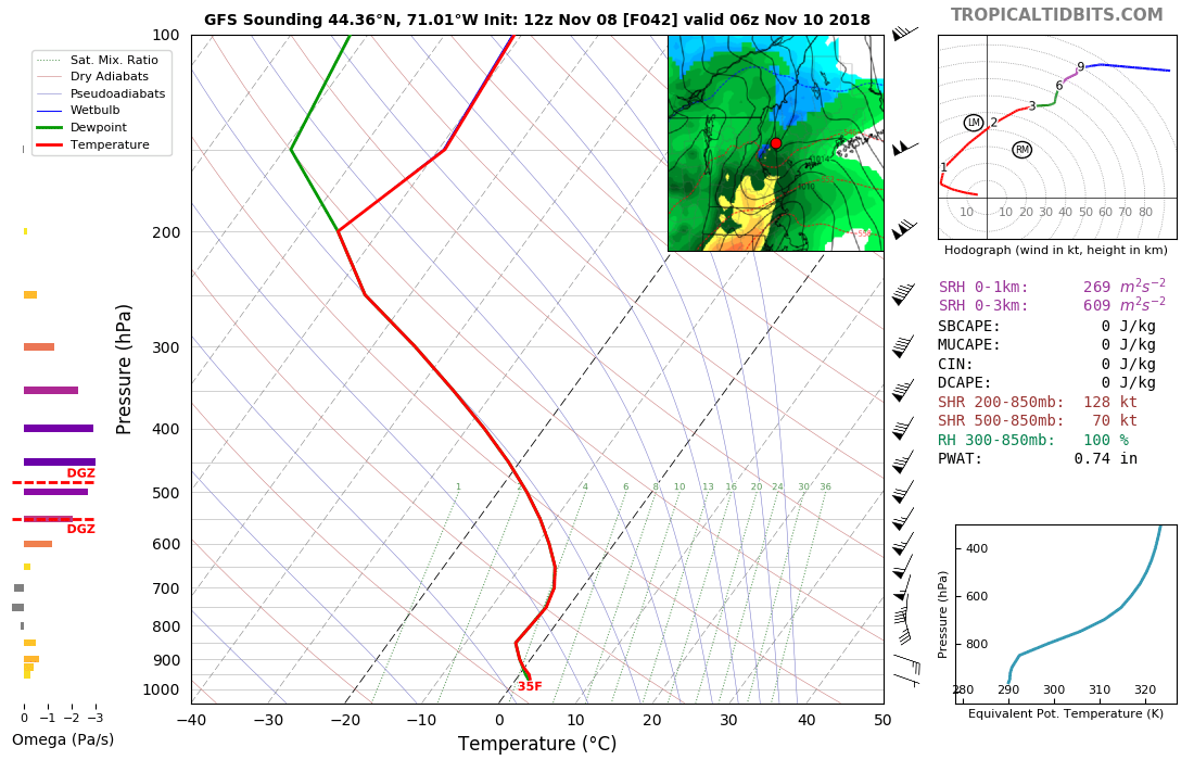
Need to see soundings as I suspect there's some marginal layer just above 850mb but it's got SFC temps of 33F widespread with this look.


Often seems to be the case with these marginal systems as the mesos do a better job of sniffing out CAD. Looking at the GFS(currently the warmest guidance I believe) sounding for my spot in Northern NH (Shelburne at 900", right on the NH/ME line), there's definitely a marginal layer around 700 or so but even at 06z it's still a snow sounding down to the final couple hundred feet above the surface. I'd imagine with good enough rates we'd see some 33f paste but it's so marginal that we'll just have to wait and see what verifies.
Either way, should be some good early season base building for the higher elevations and probably a nice ski day on Saturday for Sunday River and Wildcat.

11/27 - Everything and the Kitchen Sink Obs
in New England
Posted
Hit a nice snow shower on 89 around mile 45 in NH (Grantham area). Can see the elevation gradient clearly on the highway as we were going through NH - looks a little less exciting now as we've crossed into VT but I would imagine things will perk up again as we get up into the mountains. Should be a great day at Sugarbush - get out and enjoy the snow!