

SR Airglow
-
Posts
4,026 -
Joined
-
Last visited
Content Type
Profiles
Blogs
Forums
American Weather
Media Demo
Store
Gallery
Posts posted by SR Airglow
-
-
Any thoughts or opinions on a trip to Revelstoke in March given the current outlook for winter? Obviously they're not favored in a Nino setup but beyond that I really have no idea what their climo/pattern/favorability is.
-
17 hours ago, 40/70 Benchmark said:
Anyone know of any free graphic tools for making maps?
TIA...
I use GIMP; it's got a fairly steep learning curve to understand how layers work but once you're up to speed you can make some nice looking products relatively quickly; here's an example.

-
 2
2
-
-
Took a two hour ski tour around the hill during the height of the banding (5:30 - 7:30 ish) and that redeemed a lot of the negatives about this event. Not sure what the final was here since I didn't keep any measurements but likely a respectable amount in the end - 15" ish?
-
4 minutes ago, wxsniss said:
Finally for Fella / SR Airglo / SBosWx and others in Boston metro... it's been like watching paint dry for improvement in flake size for past hour but we are finally tasting the edge of the meat... she's fading but there are solid 30+ dbz returns... at the rate it's moving, this looks healthy for next 1-1.5 hours at least
H7 fronto:
Yeah we're doing much better now - not pounding yet but solid improvement in flake size and fluff factor. Heading up to the top of the hill to attempt to build a ski jump shortly since driving to wawa is probably a no go right now.
-
Finally starting to pick up here - let's make this band count!
-
1 minute ago, sbos_wx said:
This. Is. Bull****.
Embrace the bust.
-
Looks like the ocean band is dying. Congrats IJD-ORH-MHT on this storm it looks like.
-
1 minute ago, sbos_wx said:
The band rotating in isn't really becoming impressive at all.
Better than flurries which is what we've got right now. Not sure why I'm surprised that ORH stole our snow - seems to happen in every banded event

-
1 minute ago, sbos_wx said:
Over ORH per usual.
Flake size here is pathetic.
Hopefully we can manage a band for the both of us now.
Solid flizzard here. Not calling bust yet but this band better deliver.
-
3 minutes ago, summerthyme said:
Really not doing that much here in Brookline. Salivating at that band in Metrowest right now.
Yeah still pretty meh here on Mission Hill - had a quick period of good stuff but now the goods are to our west as opposed to our east.
-
Been stuck in subsidence the last hour or so - down to very light small flakes right now. Heavier echoes keep dying just SE of the city.
-
Just got up and it's absolutely ripping giant fluffy pillows! Wow!
-
14 minutes ago, The 4 Seasons said:
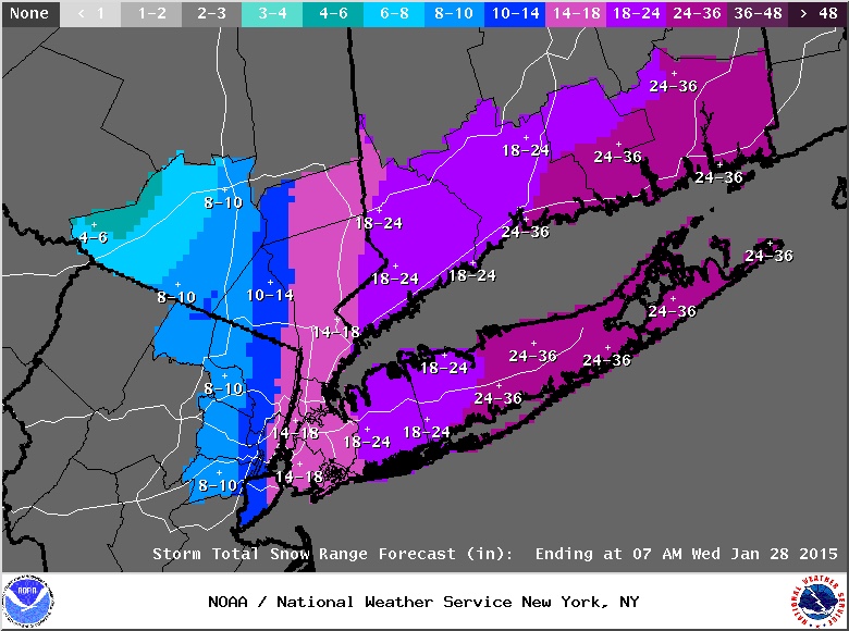
Nice but im going more uniform there is a solid sig for mod to heavy snowfall well west of the qpf maps are showing. I think there is some variability in snowfall totals no doubt, but i do not think it will be a dead W to E gradient like this map or even my first map would suggest.
Yeah I don't think it will be an exact gradient either, but it's hard to get pretty on a map when you have the uncertianty re banding that we do right now. This will definitely bust in some areas but I think I'd rather do that than go with a broadbrush total when I think there will be many areas of relative disappointment between the main bands (outside of eastern CT which is in line to get crushed). Tough call.
-
3 minutes ago, The 4 Seasons said:
I'm going up.
Ditto, fairly significantly in some spots. Someone in one of my western zones is going to get crushed with a fronto band and get 15" but I have no idea where.

-
Good hit but fairly substantially SE of 18z at 36 hours.
0z @36: 39.3/69.1
18z @42: 39.5/70.3
-
2 minutes ago, 40/70 Benchmark said:
CT never looked good for more than moderate amounts
You had 8-14" for eastern areas last night/this morning? I'd say that's certainly major in my book.
-
6 minutes ago, weathafella said:
Mid levels. Don’t ignore in favor of the siren song of qpf.
I'm not ignoring for BOS but I think CT is probably too far west to do double digits with this one. You and I are probably good for a foot I'd say.
-
Ouch. Verbatim, 18z GFS is advisory for most outside of RI/eastern MA which is low end warning. Cape gets destroyed. Give it one more cycle to see if it comes back, but Euro FTW as of right now.
We're going with 2-5" west of 91 and 5-8" east - I like that call right now.
-
3 minutes ago, Weenie said:
Hour 18 of GFS follows the same trends the other models have been following, several mb stronger when it hits the water. Might be slightly west but it's probably just noise
It's a bit east(30-40 miles maybe?) of the 12z run at hour 30 but should still be a pretty good hit I think.
-
Just now, Weenie said:
Now that DST has gone into effect, what time does the 12z NAM start releasing at?
18z NAM starts running @ 3:45.
Model times for DST;
NAM 3/9:45
RGEM 4/10:45
GFS 5/11:25
GGEM 12:00
UKIE 12:45
Euro 1:45
-
1
-
-
7 minutes ago, tavwtby said:
Huge spread on ALY probability maps... literally 0-18"...
Edit: also the only CT county without a WSW
Looks like you've got one now.
-
GFS is 978 at 39/69.5 at hour 60, juicy too. Great hit.
-
@NWSBoston Unofficial because no snowboard and it's quite drifted but estimating 8" at NEU from an average of measure's, hope still helpful.
-
Euro caves to the GFS, not as dry, but a massive cave.
Biggest bust I've ever seen from it. Unthinkable a few years ago that the euro would do that.
Upton cut totals, they had no choice.

November discussion
in New England
Posted
Borderline system for the mountains Friday night, wish we could tick it a degree or two colder with the CAD but as of right now the Euro and the GFS both bring some solid snows to NH/MH ski country (Wildcat, Sunday River and Sugarloaf especially) before an eventual changeover. Not surprised it hasn't gotten much talk considering it's cold rain for almost everyone on the board but I think it's worth keeping an eye on for the skiers among us. Could really use some base building snow up there.