

marsman
-
Posts
501 -
Joined
-
Last visited
Content Type
Profiles
Blogs
Forums
American Weather
Media Demo
Store
Gallery
Posts posted by marsman
-
-
Down to 78 with this storm from 101.2 at 1:20pm. Wundermap shows 60's! east of Raleigh.
edit: The low this morning was 77.6 at 6:20am. We're now at 77.3.
-
 1
1
-
-
102.2 at 5:10pm.
-
1 hour ago, Orange county said:
Do you have a paved Yard ?
I'm usually within +/- 3 degrees of RDU. RDU is showing 99 now per NWS, I'm at 96 at 4:10pm. The clouds are likely helping.
-
Calling it: high of 103.4 at 3pm. Currently 102.2 at 6:24pm.
-
2
-
-
Managed to get .24" from the scattered storms yesterday and early this morning, plenty for the garden.
-
No rain here yet, missed it by less than a mile. Media reporting RDU had it's hottest day of the year at 93. 91.4 at the house today, but yesterday was hottest for me at 92.7.
-
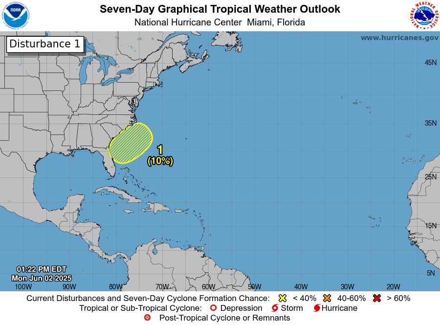
Well lookie what we have here…
Quote1. Offshore of the Southeastern U.S. Coast A non-tropical area of low pressure is forecast to form near or offshore of the southeastern U.S. coast during the next couple of days. If the system remains offshore, the low could gradually develop some subtropical or tropical characteristics later this week while moving northeastward at 10 to 15 mph. * Formation chance through 48 hours...low...near 0 percent. * Formation chance through 7 days...low...10 percent.
-
High: 91.4 on 5/16
Low: 46.9 on 5/24
6.24" for the month, 1.49" was from 5/26 to 5/31
-
Carolina blue sky this morning, low of 54.4 at 630. Windows open, no Canadian smoke yet.
-
1
-
-
.93" over the past 3 days.
-
-
91.4 at 1:14pm. Hottest of the year and first 90+ of the month.
-
2.38" since the 11th, up to 4.68" for the month.
-
.62" yesterday and 4 day total of 1.97". That's .003" shy of what I got for all of April.
-
1
-
-
.57"!
High of 88.9 yesterday (again!), low of 63.5 this morning. Garden and yard are happy. Hopeful for a smaller water bill this month.
-
88.9 at 3:50pm
-
1
-
-
High: 90.8 on 4/4! (90.4 on 4/30)
Low: 37.0 on 4/13.
Precip: 2.00"
-
whopping 0.05" from yesterday, while parts of Raleigh lost power. Low of 54.8 at 6:50 this morning.
Gets us up to 2.00" for the month, half of which was back on April 7th. That may be all we see for April.
-
Nice breeze from the outflow (correction: 0.02", up from 0)
-
Low of 47.1 at 6:30am, high of 82.9 at 4:50pm.
-
-
Low of 46.3 at 12:50am, high of 86.5 at 4:51pm
-
Low of 37.0 at 7am.
-
.75" over the past two days. Low of 45 early this morning.
June 2025 obs
in Southeastern States
Posted
And on the eighth day God created outflow: temp dropped 11 degrees, down to 84 and breezy. Amazing feeling it out there. Too bad I did all my yardwork earlier when it was sunny and in the mid-90s.