

jojo762
-
Posts
4,228 -
Joined
-
Last visited
Content Type
Profiles
Blogs
Forums
American Weather
Media Demo
Store
Gallery
Posts posted by jojo762
-
-
Man, most 00z models really missed on this fairly significant amount of wrap around snow in KS/MO/OK, im not exactly sure how much it'll amount to as far as accumulation, but this band is quite large and really nothing besides yesterday's 12z NAM had picked up on this (the 18z/00z backed off). Current hi-res models appear to be doing anywhere from modest to very poor in handling it. Hi-res models generally stink with snow, sometimes they can sniff out subtle things before globals but ouch.
-
 1
1
-
-
Not really winter related but the 00z GFS shows a potentially interesting severe setup across Kansas and Oklahoma by the 26th... lol classic.
-
 1
1
-
-
Just now, rockchalk83 said:
I'm quite surprised to see the HRRR doing this poorly. The RAP has also done pretty well with this system, too.
I'm really liking how the 12z NAM has been doing so far... Gives me some confidence in its aggressive solution for the wrap-around band tomorrow.
-
2
-
-
HRRR is doing horrible this morning, I see... really off in Kansas at least, and does not do a particularly good job with the snow in W OK either.
Other 12z CAMs (NSSL-WRF, WRF-ARW NMMB), and especially the 12z NAM are doing better.
Even so, most CAMs besides the NAM are underestimating the breadth and intensity of a lot of the bands.
-
1
-
-
Going to be awfully interesting 00z run of the ECMWF..
-
1
-
-
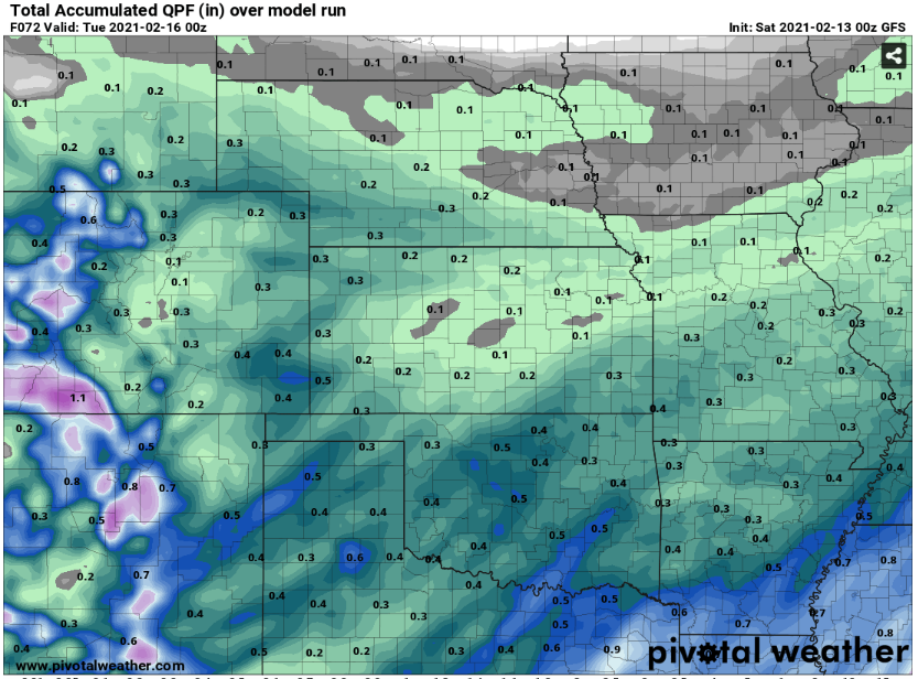
00z GFS QPF...
Using 16:1 to 20:1 ratios yields 6-8"+ for many in Oklahoma.
-
17 minutes ago, WhiteoutWX said:
While the CAMS are a little worrying for many (dry), let's wait for the 00z GFS and Euro before panicking. The CAMs may still be a bit out of their best range right now.
Agreed, i'm mostly not a huge fan of using CAMs for winter forecasting, but still not a great 00z suite.
-
00z CAMs are quite disheartening for Oklahoma...
-
25 minutes ago, StormChazer said:
Pretty neat snippet from TSA on the lake effect snowband from Oologah.
40:1 SNOW RATIO from this band.
I wonder if this is it's own beast, or if this means there is a 40:1 potential for the system in 2 days. Surely not I would think...because that would be outrageous.
Can anyone with more knowledge on this educate me?
"The other concern in the short term continues to be lake effect
snow streaming off of Lake Oologah. The latest radar imagery
continues to show a relatively impressive and narrow band of snow
streaming off of Lake Oologah. KINX is also suggesting a small, not
nearly as impressive band of lake effect snow streaming off of
Grand Lake which is oriented somewhat favorable with the
environmental winds. Total snowfall of up to 1" has been reported
within the lake effect snow band from Oologah. An NWS employee
located under the band measured 0.8" of snow this morning which
melted down to 0.02" of liquid resulting in a snow ratio of 40:1.
This ratio is expected to maintain within this lake effect band
through the afternoon, evening and overnight hours. The latest
guidance continues to suggest NNE winds will not end anytime soon
thus opted to extend the localized lake effect snow for Oologah
and to a lesser extent Grand Lake through tomorrow morning. As a
result, an additional one half inch of snow accumulation is
possible from the Lake Oologah lake effect snow band while a
quarter of an inch will be possible within the Grand Lake lake
effect band."
LES bands usually run 20:1 to 50:1... (huge variation, obviously) so that sounds about right, especially given the super cold conditions. Impressive nonetheless.
-
 1
1
-
-
4 minutes ago, JoMo said:
12z Canadian drastically increased amounts from last night... Late to the show, Canada... late to the show....
I'm going to set my disappointment threshold to 4" of snow. If I get less than that, I'll be sad, more than that, I'll be ecstatic.
Still possibly a few inches short though for much of Oklahoma, and parts of Kansas/Missouri.
-
Do not believe this has been posted yet, but OUN's AFD this afternoon did an excellent job of summarizing the snow potential for many of us in the forum.
QuoteThe storm system of interest, currently still located over the Pacific, will begin to impact our region as early as late Saturday night. An anomalously cold airmass will be in place ahead of this system which will allow for an all snow scenario, even across our traditionally warmer southeast counties. Models are in general agreement bringing a wide swath of 0.3" to as much as 0.8" of QPF to the area. The GFS and its ensembles have been in good agreement and have stayed toward the higher side of this range. The deterministic ECM agrees with the GFS and GEFS, but is a bit of a high outlier within its ensembles. GEM/NAM appear more progressive and are drier outliers at this stage, with 0.1-0.3" QPF. All this to say, there is still some uncertainty in exactly how much snow will fall, but given snow to liquid ratios of 15:1 to perhaps greater than 20:1 at times during this event, it won`t take a ton of moisture to produce significant snow totals. We are taking a middle of the road approach for now, with 0.4-0.5" of QPF, leading to widespread snow totals of 6-8", locally up to 10", with highest amounts focused across northwest OK where ratios are highest.
-
15 minutes ago, JoMo said:
00z Euro interacting with the lead wave more out to 54 hours. We'll see how this goes....
Does not seem like there was too much of an appreciable change to the end result. Still impressive snow totals area-wide, maybe slightly less bullish for some -- definitely less widespread 0.5" QPF than yesterday's runs.
-
2 minutes ago, rockchalk83 said:
I noticed that, too. Seems squirrely to me. Also not buying the hard stop to the precip shield in E KS and MO. Think we'll see widespread QPF south of I-70 of greater than .4".
The QPF that the NBM is shooting out is completely perplexing, as is the snow map. No answers for either, really. NBM is typically modestly reliable, given that it is a blend -- sorta like buying SPY instead of picking stocks, its hard'ish to beat the market. haha
-
1
-
-
Just now, JoMo said:
Probably the NAM just being awful like usual.
Almost certainly... as usual, this 84 hour NAM forecast can probably go straight into the trash.
-
1
-
-
00z NBM snow map continues to be a compromise between the more bullish ECMWF/GFS and the more bearish GEM.
However, something appears to be awry with the aggregate SLRs in the model, as the QPF field would indicate a much more bullish snow solution -- more in line with the GFS/Euro, especially for the western half of Oklahoma. Interestingly there is a rather steep gradient in the QPF output on the NBM that essentially bifurcates Oklahoma and Kansas -- not exactly buying that.
-
1
-
-
Anyone else finding themselves waiting for this storm to totally fall apart?
-
1
-
1
-
-
Everyone is right that under normal circumstances Kuchera SLRs do fairly poor, and almost always overestimate snowfall. But we are talking about 15:1 to potentially 25:1 SLRs for most people here basing off current temp forecasts. In this situation I don't think the Kuchera snowfall numbers are signifcantly off, espeically on Pivotal weather -- WxBell seems a hair higher for whatever reason.
For anyone with a distrust of the Kuchera snow outputs, just manually multiply QPFs by 15 or 20 or 25 to give you a rough idea of what we could be looking at (its pretty similar to what is being shown).
-
3
-
-
1 minute ago, Solution Man said:
Agree, kind of brutal when you have the climate and can’t snow
Not looking forward to AWFUL roads again. The roads on Sunday/Monday were brutal across most of the metro, even in Johnson County which typically does a great job plowing and keeping roads clear.
-
1
-
-
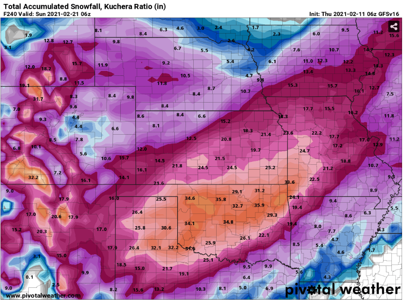
4 minutes ago, The Waterboy said:
Can someone post the 06 v16 clown map? It’s insanity but fun to look at. 3 feet for Tulsa.
For posterity thru 240hrs.
-
1
-
2
-
-
1 minute ago, JoMo said:
The main failure point would be a weaker wave that doesn't take on a neutral/neg tilt. If this is just a positive open trough, then that wouldn't be good for big snow totals.
Thankfully the Canadian is mostly on an island of its own wrt a weaker less amplified wave... Not to say that it couldn't end up winning on this system vs the other globals, but just seems unlikely.
Seems like the 84hr NAM is more like the Euro/GFS, as well...
-
1
-
-
Looks like 12z GFS was a bit of a snowfall upgrade for most compared to the 06z, but still a tad less than 00z. Getting close to that period in model land where it is hard for them to be off astronomically. Meteorology is often a humbling science. In this case, the difference between 6" of snow and over a foot of snow comes down to nebulous details of isobars several thousands of feet up in the atmosphere, in addition to other mostly nuanced factors.
-
 1
1
-
-
1 minute ago, StormChazer said:
The Euro maintains!
Somehow even more impressive than the GFS... Geez.
-
2
-
-
00z UKMET was a good mix of the CMC vs. GFS/Euro. More QPF than the Canadian, but less than the GFS/Euro.
UKMET maxes out at ~0.5in of QPF over a small portion of OK whereas GFS/Euro have 0.5-0.9in QPF over a much larger area.
Looks like 00z Euro is coming in now...Out to hour 54 as I type.
-
2 minutes ago, JoMo said:
Guess I'll force myself to stay up for the Euro. I think the entire system fits inside the 120 hour "great" range of the Euro tonight.
Only an hour and a half or less to go!

-
1
-
MO/KS/AR/OK 2020-2021 "Winter" Discussion
in Central/Western States
Posted
Evergy, who serves the eastern half of Kansas/western half of Missouri, announced they would be instituting rolling black outs in their coverage zone as well...
As per SPP guidelines... Going to be an interesting next couple days for many.