BeauDodson
-
Posts
417 -
Joined
-
Last visited
Content Type
Profiles
Blogs
Forums
American Weather
Media Demo
Store
Gallery
Everything posted by BeauDodson
-

Summer 2024 Medium/Long Range Discussion
BeauDodson replied to Chicago Storm's topic in Lakes/Ohio Valley
They batted about 80% last year with long-range outlooks. They have come a long way since their infancy years ago. Their farm and garden videos, GFS analysis, and EC analysis videos are excellent. They have an amazing team of meteorologists. Years ago, I felt the same way. But, over time, they have become a great company!
-
Summer 2024 Medium/Long Range Discussion
BeauDodson replied to Chicago Storm's topic in Lakes/Ohio Valley
You can see where the ridge set up shop over the last three weeks. The haves and have-nots. Too much rain and too little rain.
-
Summer 2024 Medium/Long Range Discussion
BeauDodson replied to Chicago Storm's topic in Lakes/Ohio Valley
Our long-range team has a great video today about July's weather. A bit of a nail-biter for the Ohio Valley. We will have to see where the ridge sets up. Would not be surprised to see the MCS train produce pockets of ten or more inches of rain. These videos can be viewed on our www.weathertalk.com app. If you don't live in our area, then choose any given county and then download the app to view the daily videos. -
Historic Lake Effect Event?! 11/17-11/21
BeauDodson replied to BuffaloWeather's topic in Upstate New York/Pennsylvania
It appears the GOV is closing most roads at 4 PM. That shuts me out. Disappointed, but it is what it is. I have to be at NWS conference this morning. Otherwise, I would have left last night. Be careful, everyone. Enjoy the white gold. Looking forward to the photos and videos. -
Historic Lake Effect Event?! 11/17-11/21
BeauDodson replied to BuffaloWeather's topic in Upstate New York/Pennsylvania
What Discord room is that? Thanks -
Historic Lake Effect Event?! 11/17-11/21
BeauDodson replied to BuffaloWeather's topic in Upstate New York/Pennsylvania
Hoping I can come in from the south tomorrow afternoon. Sounds like they will close it. Unsure another way in.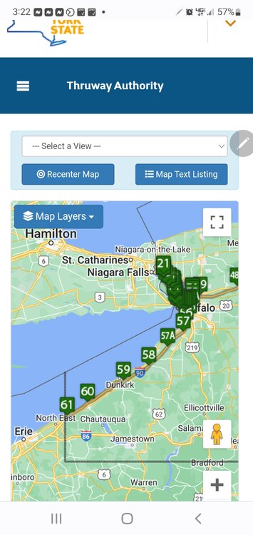
-
Historic Lake Effect Event?! 11/17-11/21
BeauDodson replied to BuffaloWeather's topic in Upstate New York/Pennsylvania
What are you driving once there? -
Historic Lake Effect Event?! 11/17-11/21
BeauDodson replied to BuffaloWeather's topic in Upstate New York/Pennsylvania
Interesting setup for LES. I remember the 2000 event. Incredible totals. Quite a bit of thundersnow. I'm thinking about chasing this one. -
Winter 2022/23 Short/Medium Range Discussion
BeauDodson replied to Chicago Storm's topic in Lakes/Ohio Valley
Is this the correct thread for the Buffalo area? Thanks -
Devastating tornado strikes Joplin, Missouri
BeauDodson replied to Hoosier's topic in Weather Forecasting and Discussion
Hi JoMo, I thought about you on the anniversary of the tornado. It is hard to believe that it has been ten years. It seems like yesterday. I don't come on the forums very often, but was browsing it this morning and noticed this thread was still active. I hope you are doing well. I can't imagine the amount of trauma associated with an event like this. I can only compare it to what I saw after Katrina and Rita. It is hard to fathom so much destruction and loss of life. -
Devastating tornado strikes Joplin, Missouri
BeauDodson replied to Hoosier's topic in Weather Forecasting and Discussion
Was thinking about you today. Popped into the forum to see if this thread was still alive and well. I see that it is. I agree, it is hard to believe that it has been five years. Hope you are doing well. -
Devastating tornado strikes Joplin, Missouri
BeauDodson replied to Hoosier's topic in Weather Forecasting and Discussion
Weather Brains had an interesting guest on recently. Dr. Jason Persoff. He recounted his experience in Joplin immediately after the tornado struck the city. http://weatherbrains.com/weatherbrains/?p=2138 -
Devastating tornado strikes Joplin, Missouri
BeauDodson replied to Hoosier's topic in Weather Forecasting and Discussion
I agree 100%. I have caught errors on this subject more than once. It is a concern. I am going to bring it up again with our local office. Especially after the answer I was given earlier this year. -
Devastating tornado strikes Joplin, Missouri
BeauDodson replied to Hoosier's topic in Weather Forecasting and Discussion
Although I can't answer for him I find the service assessments extremely valuable. I read them all - have them all printed out - keep them here on hand for review. I think the NWS, emergency management, media, and others read them - utilize them - take them for what they are. I learn something from each assessment and make changes accordingly. From talking with others - they do the same. The process isn't perfect - it is evolving - will continue to evolve. The more we learn - the more we realize we have a lot to learn. -
Devastating tornado strikes Joplin, Missouri
BeauDodson replied to Hoosier's topic in Weather Forecasting and Discussion
Unfortunately this book is being sold in many outlets - to the public. I am not sure how someone outside of the meteorological community would view this. It makes the NWS look incompetent. I do agree with Mike on some of the topics brought up within the book. Some of them are the same concerns raised in the service assessments. Of course service assessments are not read by the general public. If this publication was for internal purposes then I would view it as a severe lashing against the NWS, some in the media (although they are excused somewhat in the book because they were parroting what the NWS said), and emergency management officials who didn't blow the sirens properly. For a publication like this to be sold to the public - not sure it is helpful or useful. It does strongly promote their private warning service. I am not sure how many times their private warning service was mentioned - but several times. Emphasis was added that they got the track right and the NWS got the track wrong. Critique is important within the weather community - there are several private and semi-private forms to do just that. Critique can be important in moving everyone forward - improving products issued for the public - improving siren policies - other. However, I would agree with some others with the same sentiment that the book is a bit disappointing in the approach. When one group/agency makes another group/agency look like fools - with little mercy - then eyebrows are raised that there is some sort of agenda at hand. I am afraid this is what the book left me wondering. The book raises some important points - valid concerns - items of interest. The approach, though, was disappointing. The NWS had a very difficult job that day - emergency management had a very difficult job that day - the manner in which the storm formed, exploded, evolved made for a perfect storm of sorts. Unfortunate and so was the outcome. -
Devastating tornado strikes Joplin, Missouri
BeauDodson replied to Hoosier's topic in Weather Forecasting and Discussion
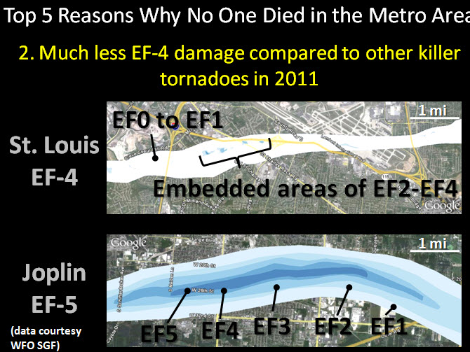
It was a very small area with EF4 damage. -
Devastating tornado strikes Joplin, Missouri
BeauDodson replied to Hoosier's topic in Weather Forecasting and Discussion
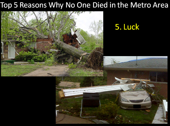
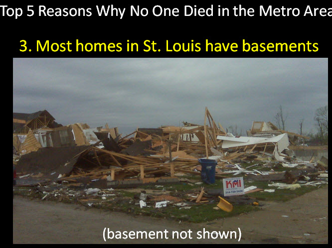
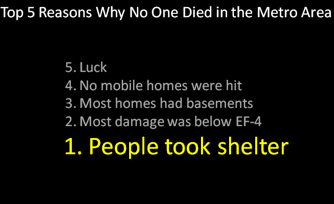
If is funny you should say that - because One of the NWS meteorologists, from the St Louis, Missouri - National Weather Service Office, did a presentation (last fall - at the big NWA conference) in Birmingham, Alabama on their EF4 tornado event. She said that the reasons there were not more fatalities in the EF4 St Louis tornado was - wait for it and drum roll - LUCK She had a list - but LUCK was, if I remember correctly, number 5 on the list. This is what was on her slide presentation
-
Devastating tornado strikes Joplin, Missouri
BeauDodson replied to Hoosier's topic in Weather Forecasting and Discussion
I am not sure a tornado emergency would have mattered. Maybe for the on-air people? Unsure. We will never know. Of course now we have the new warning system = Springfield is one of the offices using the new terminology that attempts to predict how much damage a tornado will or won't do. It would not have mattered in this event. It was too late - not to mention that I don't think hey had enough time. I have seen some meteorologists that focus on "their idea" of where a storm should track and if radar is showing something different they still seem to not catch on. In school this is called tunnel-vision. I said it must be going northeast and it must be heading to town A B and C. By the time you realize it isn't happening as you expected then it is too late. Not saying that is what happened here - but the evidence stacked up by Mike in his book does suggest that concept. At least as a potential. It is too bad there was such a delay in the tilt scans. Had they had the phased array radar then this would have likely ended a lot differently. This is where local radars - owned by television stations - can be of some value. It is too bad the NWS can't zero in on a storm and get faster updates. -
Devastating tornado strikes Joplin, Missouri
BeauDodson replied to Hoosier's topic in Weather Forecasting and Discussion
Mike brings up that subject, as well. -
Devastating tornado strikes Joplin, Missouri
BeauDodson replied to Hoosier's topic in Weather Forecasting and Discussion
Not sure the DOC allows me to post the logs - I have them. Just not sure if I can post them or not? They are interesting because they show a lot of communication about what is happening to the City of Joplin and before Joplin. From the logs there appears to a lot less confusion as to what is/was going on - at least when you compare then to the statements that were actually put out by the NWS for the public. -
Devastating tornado strikes Joplin, Missouri
BeauDodson replied to Hoosier's topic in Weather Forecasting and Discussion
This is a problem. I hope this issue has been addressed within the NWS. I am a bit alarmed by the incident a few weeks ago in my local area - afternoon reading your comments and this book. If a computer is spitting out these names and errors and the NWS isn't "catching it" - then we have a problem. I don't know if this is a bigger issue or not. It is a question worth discussing. Surely the NWS can correct the storm movement based on what they were seeing. Or - perhaps in this case - it was simply just a bad error. -
Devastating tornado strikes Joplin, Missouri
BeauDodson replied to Hoosier's topic in Weather Forecasting and Discussion
I don't disagree with your assessment after the fact. My concern is that people were not reading the warnings. Who do we know that reads tornado warnings? They were likely going on what the on-air people were saying (and according to Mikes book) the radar stations were telling them. They were not telling them that they were in danger. It is obvious - after seeing the warnings/svs - that there was a lot of confusion. Mike is likely correct on that subject. I think there may have been more confusion than some of us from outside the region realize. This is because of the on-air meteorologists and radio broadcasters reading the warnings and not checking their own radars for verification of what the NWS was saying. Mike even goes as far to say that the on-air mets didn't even realize they were looking at a tornado on their tower cam - they thought some of the power flashes were lightning. It wasn't until it was too late that they realized they were looking at a very large tornado hitting their city. Was a tornado emergency issued? I don't remember. I remember being in chat that day and telling them that there was a lot of damage being reported - also reported some baseball size hail. Mike says - implies or says - that hail was never a concern and that baseball size hail never occurred. I remember making a report to their office of baseball size hail somewhere north of Jomo. Do not remember exactly where - but it the report was made. Of course nobody cared about the hail at that point - it was too late. Mike also has some eye witness accounts that told him they felt the main concern for Joplin was hail and this was based on what the media was saying. I should pull up the logs from that day and see what was being said in the room. -
Devastating tornado strikes Joplin, Missouri
BeauDodson replied to Hoosier's topic in Weather Forecasting and Discussion
And this is apparently where the confusion was - on-air mets and radio rip and read were telling people the wrong area. I guess the next question is how many residents heard the wrong information and thought "that is not near me - I am safe" We will never know. According to the book some people interviewed said they kept talking about Galena and they felt safe in southern Joplin. Someone with a radar should have caught the mistake. Private meteorologists - on-air television meteorologists - others. We knew this was an error on the forum - or we at least knew Joplin was in serious trouble. Why didn't others know this? Was it because they were too busy covering the storm - weekend - not enough staff? Had this been in Oklahoma City then I can almost guarantee you that the on-air mets would have caught it. They have their own radars - they would have been able to see that the storm was forming and moving east into the part of Joplin that was hit. Do any stations in the Joplin region have their own radar equipment - Barron or other? -
Devastating tornado strikes Joplin, Missouri
BeauDodson replied to Hoosier's topic in Weather Forecasting and Discussion
I think there is the issue - brought up in the book. That does not mesh. If the tornado was 6 miles northeast of Galena and moving northeast then the tornado would not have hit Joplin or at least southern Joplin. On that track it would have taken the tornado north of Joplin - or most of Joplin. This raises the question - was it a mistake? Were they playing the odds on where the tornado was located based on radar and conflicting other reports? The storm evolved so fast that they did not know what was going on? They had spotter reports indicating a tornado in an area that their radar wasn't even showing the tornado - yet? I don't know what was going on. If spotters reported the tornado near Joplin - did the NWS believe them on the location? Did someone assume that the spotter was wrong and the tornado was actually further north (or according to that statement - 6 miles northeast of Galena) -
Devastating tornado strikes Joplin, Missouri
BeauDodson replied to Hoosier's topic in Weather Forecasting and Discussion
Yes, I remember that during the event - we were discussing it in the forums. I think a lot of people among our group realized the risk for confusion was high. Thus the nature of multiple tornado warnings. I think some in the media were caught off-guard by the extreme nature of the tornado - as mentioned also on WeatherBrains the other week. Developed fast - grew in size and intensity fast - sirens sounded county wide for the first storm - confusion over the second storm - media focused on storm A instead of A and B. It was an episode of "It Could Happen Tomorrow"