
zenmsav6810
-
Posts
969 -
Joined
-
Last visited
Content Type
Profiles
Blogs
Forums
American Weather
Media Demo
Store
Gallery
Posts posted by zenmsav6810
-
-
On 4/15/2024 at 5:15 PM, Birds~69 said:
Way too hot today. Looking forward to several days of clouds/rain to end the week/weekend and some 50s for highs...
79F
Never got quite that hot here in the hills of NW Chesco. It was pretty breezy on Monday.
-
1 hour ago, RedSky said:
Second week in a row a very wet looking three days has been reduced to .25-.50" qpf.
Won't have a record wet month doing this. Drought talk soon? Lol
Bear here last night. Repellant needed list is growing mosquitoes, bees, bear spray?
The end of El Nino?
-
 1
1
-
-
Lucking out with the weather recently. Last week a followed the blizzard to some fresh powder skiing in Pico, VT- thankfully no snow on the NY thruway which stayed rain most of the way to the mountains. Two nice days over the weekend and just high altitude clouds for the Eclipse which made for great viewing.
-
1 hour ago, LVblizzard said:
Just had a really gusty shower pass through Allentown. It was almost like a thunderstorm, but without thunder and lightning.
Microburst are often but not always associated with thunderstorms. Interesting weather- I find it very typical March weather for the area.
-
18 hours ago, LVblizzard said:
Already seeing some trees blooming here. I can't remember seeing that this early. Usually it doesn't happen till early April.
2012 it happened even earlier believe it or not.
-
15 hours ago, Hurricane Agnes said:
LOL I remember as a senior in high school back in '79, my high school Physics class took a trip there while it was under construction (the cooling towers were just being built). The PECO tour guide told us that when it was completed, our electric bills would be reduced to $3 a month!


Anyway, it was a gorgeous day today with daffodils in bloom and even some cherry trees. I ended up with a high/low of 66/37 yesterday, and 71/41 today. My last 70+ temp was Oct. 27 of last year.
Currently 56 with dp 38.
PECO should have invited the math class instead-- its sounds like that's where they really needed the help!!
-
 1
1
-
-
Just now, Newman said:
I'm in northern Sweden for the month of March, took these yesterday!
Neat-- I've always wanted to go. Im working on learning Swedish.
-
The looks for NE are pretty good for this month.
-
On 2/26/2024 at 12:24 AM, RedSky said:
GFS almost pulls off a Daffodil crusher at 300+ hrs
It fits the winter pattern..
Probably more like a Tulip crusher. Some of daffodil will be finished by then.
-
5 hours ago, Albedoman said:
yes I agree with El nino pattern statement should be expected rains and warmth but not to that extreme that we all experienced. December had the most rain ever recorded in the LV which rivaled good hurricane season rains and flooding was unbelievable. I am also sure it was the cloudiest periods ever for the winter season. Somebody needs to find this out. We went in 5-6 day mostly cloudy stretches for at least two months with no 2-3 day consecutive sunny days That should have been a good tell how this winter was going too.
Interesting observation. Its kind of like tornado alley shifting 150 miles eastward over the past few decades.
-
16 hours ago, Albedoman said:
I am an official spotter for the NWS for the last 25 years or so. I reported that measurement. I do not hype measurements. I was not kidding with all of observations about the snowfall and snowflakes. I live about two miles from the resort. The total after the snow squalls was over 14 inches. I still have 10+ inches on the northern side of the house. The southern facing sides lost all but about 6 inches.
Indeed, it was a good measurement. Unbelievable how localized the totals were.
-
This did not disappoint. The 13.8" in Macungie lived up to the hype at Bear Creek Mountain Resort-- deepest fresh powder I've ever skied. It was like the perfect amount. Definitely the light fluffy high ratio stuff!
-
1
-
-
2 hours ago, Ralph Wiggum said:
Watch it take the win now.
Weenie rule number 1- don't count your snow before it falls!
-
1
-
-
1 hour ago, Ralph Wiggum said:
Really can't complain about this winter considering we are in a Nino. We are near avg snowfall to date and have had like 8 separate little events so far. I'm at a C+ grade currently, let's see what happens tonight.
All we are missing is the Big one.
-
1
-
-
Sun is out here in Thorndale. Roads were rough getting to work. No all-wheel drive = stay home. All sorts of carnage on the road from Tractor trailers to Toyotas to Bamboo and Telephone poles. Modeling saying there's a chance at some more snow on Saturday too!
-
10 minutes ago, Birds~69 said:
Must be hail, it's 43F...
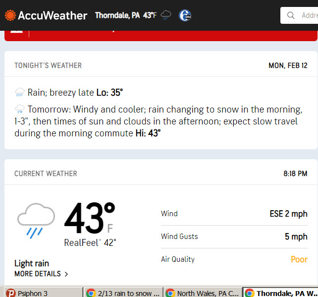
41 according to the car...were talking like 3% sleet and big rain drops
-
It had Started rain/sleeting when I left work in Thorndale at quarter of 7.
-
1
-
-
42 minutes ago, Birds~69 said:
CBS3 gives Philly just about squat...
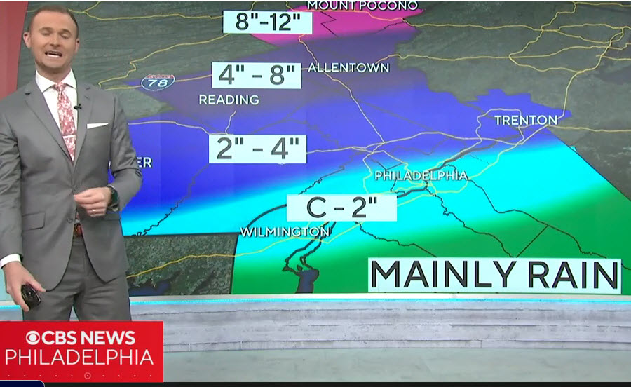
If I could double weenie that map I would...
-
1
-
-
54 minutes ago, Newman said:
Berks and Lehigh counties look to be in the best spot for this as of now. Probably start as some brief rain, unlike those in Carbon/Monroe counties. But the strongest banding and snowfall rates will slide through south of the Poconos for the longest duration. 6-10" thump in that area
I'd probably add High Elevation NW Chesco to that list.
-
1
-
-
5 hours ago, Hurricane Agnes said:
It's been good to see the sun for a somewhat extended period and my obs for highs the past couple days have been mainly mid 40s (45/46/45) with lows in the upper 20s - mid-30s (35/29/30).
This morning the radiational cooling and dry air got me much colder, where so far my low has been 27.
Currently 27 with dp 15. Looks like a torchy weekend ahead.
Wiggum criteria for 2/14?
-
 1
1
-
-
1 hour ago, LVblizzard said:
I fly back to Philly from Denver late Sunday night and I likely won’t be getting back to Allentown till 2 am. Guarantee this will happen the one time I don’t want a snowstorm.
Never turn your back on the weather!
-
Preceding this event were a few lovely sunrises and sunsets.
-
1
-
-
7 hours ago, Ralph Wiggum said:
GEFS and GEPS and EPS to a degree all have a small window around the 29th with a system tracking under us. Problem is antecedent airmass may not be too favorable. CMC and GFS op are close to something. Looks like a spring storm with higher elevations favored.
Looking out into fantasy land, weird to keep seeing something consistently popping up on the super extended stuff centered around Presidents Day. Big ones sniffed out early
 ?
?
Don't they normally tend to trend North as the date gets closer? ...Roll out the hot dog cart. Suppression at this range isn't super concerning- something to keep an eye on certainly.
-
1
-
-
We might be seeing some high ratio snow with this setup so I think the widespread 4-6" is a good call. With some luck and if this Norlun (which don't always show up on modeling) gets pumping the moisture somebody could Jackpot with 8" or 10" (maybe in Nantmeal, Huff's Church, Finland Village etc.). Although I think we'll be seeing more like 3-4" imby.
-
1
-
E PA/NJ/DE Spring 2024 OBS/Discussion
in Philadelphia Region
Posted
We got a wiper washer on Saturday night so not as bad here. Allergies have been brutal this year.