RDM
-
Posts
1,477 -
Joined
-
Last visited
Content Type
Profiles
Blogs
Forums
American Weather
Media Demo
Store
Gallery
Everything posted by RDM
-
Steady at 36F now. Was getting some white rain with the heavier band. Slacking off now and only rn- atm.
-
If only that 12k were to validate... Most of the forum would be happy campers. NJ and NYC would be shut down for a long time.
-
36F with rn/sn mix. Some fatties mixing in but not many atm. Lots of moisture in the fetch running across the SE into the GOM.
-
Based on NWS radar loop, it appears to be snowing along the M/D already - although it could be virga. Precip field has really blossomed the last couple of hours.
-
Yup don't recall a setup in recent memory where the Warning map nearly encircled DC as it does now. Sad
-

The February 22-23 Late Season Miracle: JV Disco/Banter Thread
RDM replied to bncho's topic in Mid Atlantic
Yup - similar here. High of 54 this afternoon and down to 40 already. Cooling off nicely. -
The Blizzard Warnings were expanded significantly inland along eastern PA, NJ and a good ways up the Hudson in an arc around RI and Mass. My wife is living temporarily in NYC on the upper West Side and taking Amtrak back tonight to avoid what will likely be a shutdown of Amtrak in the NW corridor tomorrow. Tempting to go with her to see NYC get nailed from her 23rd floor view. Had a nice snow in Dec that was awesome to watch from an elevated perch.
-
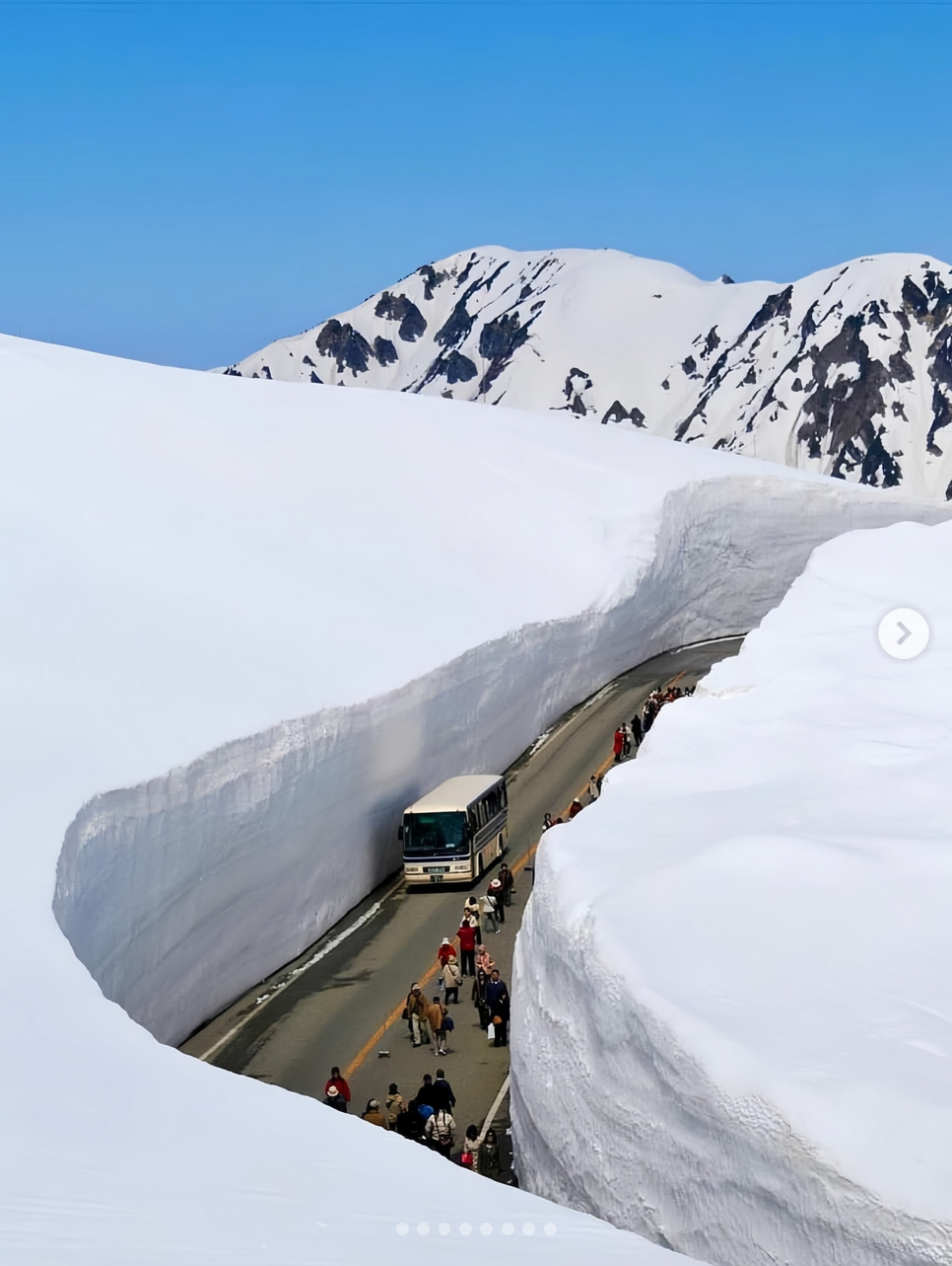
Glad you like it. Here's another shot for you. Search on "Incredible deep snow in Japan"

-
Here you go... Below is just one picture from a web search. They use bulldozers and snowblowers to keep the road open until the chasm becomes too steep to blow the snow out. Separately, Gassan had the deepest snow depth of any resort in the world in April 2025. 380" https://www.snow-forecast.com/whiteroom/japan-weekly-roundup-291/
-
Great! - been to the BX at Yokota AFB many times. Hope you have good memories of your time there. You are the first person I've ever "met" who knows about Zao. It's a great area. Never been there in the summer time, but can imagine it would be a nice place to visit without snow too. Heard of Aomori, but haven't been there. Climbed Fuji san and skied down once (on telemark skis) with a couple snowboarders. That was a surreal experience. Had great weather with unlimited visibility just after a cold front went through.
-
If you, Jebman or anyone ever get the chance to visit Japan, suggest going to Zao or Naeba. Zao NW of Tokyo several hours. It is famous for its "snow monsters", which are the wind-swept snow-encrusted tops of pine trees sticking out of the snow. When I was there telemark skiing, there were only 10-20' of the tree tops sticking out of the 60-70 feet of snow. It was amazing how much snow they had, even by Tahoe standards. It was very interesting how they deal with the snow. The Japanese have snow removal down to an art. Downtown Zao and Naeba (not very big villages) have perforated rubber hoses laying all over the streets and sidewalks. They pump hot water from the natural springs out to melt the snow. The whole area smells like sulfur, but you get used to it. Where they don't have hot water running, they use a variety of snow blowers to discard it. There's simply no place to push it - too much of it. They have some really nifty walk behind snowblowers that are really cool and it seems everybody has one. When it snows on the western flanks of Honshu (the main island of Japan), the fetch off the Sea of Japan is accented by the upslope from the Japanese Alps. The result is akin to what Mammoth is experiencing, and then some. Never seen snow so intense for so long. If you ever do go, hit me up offline. Happy to give some ideas. Heading to Japan in a week for several weeks. Unfortunately, I don't think we'll be heading to the mountains this time.
-
Totally agree and well said. Not to be uppity, but I've been here and Eastern since 97. None of us ever learned anything when posting. I'm immensely grateful for all the insight from the red taggers and those more experienced posters who really know what's going on. Many of the younger crew are catching on, but still need to post less, read more, learn and avoid jumping the gun. Unfortunately, that's the era we live in with today's immersive social media frenzy. Mods - sorry for the banter.
-
rotflmao That's hilarious, albeit not far from the truth.
-
Oh my - the view from the cam is currently amazing. Full bore dumping ongoing.
-
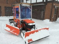
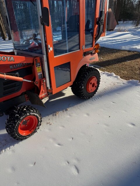
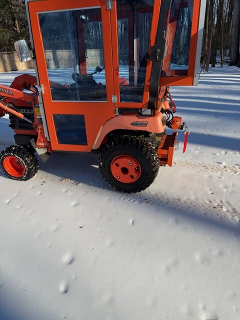
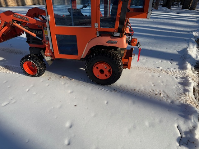
As everyone knows, this ice pack from the frozen sleet is still hanging in tough. The glacier in our back yard fully supports my small Kubota tractor, which weighs in around 2200lbs. With the wood in the loader, it's closer to 2500 lbs as shown. The tires barely leave a mark on the surface.
-
Good point - dunno anymore. I still remember #1....
-
Any of those artists and many more would have been better and far more representational of what the Super Bowl is supposed to be about.
-
Singularly the worse half-time show in history. What executive thought that was a good idea? It was unwatchable. So sad this is where things have migrated to in pro sports. Wish we could be in the board rooms when the executives digest the data from FIOS and other streaming devices when they see how many people turned to something else.
-
Put out a few mins ago.... Special Weather Statement National Weather Service Baltimore MD/Washington DC 1253 AM EST Sat Feb 7 2026 MDZ003-004-502-VAZ028-031-505-WVZ050>053-504-070630- Central and Eastern Allegany-Washington-Frederick-Clarke-Frederick-Western Loudoun-Hampshire-Eastern Mineral-Jefferson-Morgan-Berkeley- 1253 AM EST Sat Feb 7 2026 ...SNOW SHOWERS WILL AFFECT WASHINGTON COUNTY IN NORTH CENTRAL MARYLAND...EAST CENTRAL ALLEGANY COUNTY IN WESTERN MARYLAND...FREDERICK COUNTY IN NORTH CENTRAL MARYLAND...NORTHWESTERN LOUDOUN COUNTY IN NORTHERN VIRGINIA...FREDERICK AND CLARKE COUNTIES IN NORTHWESTERN VIRGINIA...JEFFERSON AND MORGAN COUNTIES IN THE PANHANDLE OF WEST VIRGINIA...EAST CENTRAL MINERAL COUNTY IN EASTERN WEST VIRGINIA...BERKELEY COUNTY IN THE PANHANDLE OF WEST VIRGINIA AND HAMPSHIRE COUNTIES IN EASTERN WEST VIRGINIA AND THE CITY OF WINCHESTER... At 1248 AM EST, snow showers were located along a line extending from near Berkeley Springs to Romney. Movement was southeast at 35 mph. Winds in excess of 30 mph are possible with these snow showers along with a quick coating to locally half inch or snow. Locations impacted include... Frederick, Hagerstown, Winchester, Martinsburg, Thurmont, Charles Town, Emmitsburg, Romney, Shepherdstown, Hancock, Paw Paw, Municipal Stadium, Harry Grove Stadium, Millwood Pike, Ballenger Creek, Robinwood, Brunswick, Walkersville, Fountainhead-Orchard Hills, and Ranson. This includes the following highways... Interstate 68 in Maryland between mile markers 72 and 80. Interstate 70 in Maryland between mile markers 1 and 56. Interstate 81 in Maryland between mile markers 1 and 12. Interstate 270 in Maryland between mile markers 29 and 32. Use extra caution if you must travel into or through these snow showers. Rapid changes in visibility and potentially slick roads are likely to lead to accidents. Consider delaying travel until the snow showers pass your location. Conditions can deteriorate rapidly in winter weather situations. Be prepared for snow or ice covered roads. Slow down and allow extra time when traveling.
-
Awesome. Thanks for sharing. Reminds me of the blizzard of 78 in Ohio. We had similar conditions for 2 days. Could not see the house next door at times.
-
Indeed - Looks pretty intense out there. Here's a link to some of the traffic cams on I-68 out in Garrett Co. https://deepcreektimes.com/other-area-webcams/garrett-county-state-highway-webcams/
-
Just came in from outside. It's down to 11F already here NW of Vienna. This may end up being the coldest night yet in this run. Took a walk in our front yard on the crust. Was cool hearing the "thud" of each step as the crust flexed with each step. It didn't cave in though to my 250+ lbs. Brought back memories of growing up in Ohio and trying to tread lightly on thin crust w/o breaking through.
-
Good morning - yes on the concrete. I used the plow and snowblower on my small Kubota (profile pic) to clear the driveways and sidewalks in our neighborhood yesterday from early am till evening and then a few more hours after dinner. Got much of the snow removed on our 500' driveway before the flip, but not everywhere. At first the sleet plowed fine - flowed like sand. After it sat for a while it congeals into a semi-icy mess. If the plow can find a way to pop it up from the bottom, that helps fracture the mess into movable chunks. Otherwise, the tendency is to just skim over the top. Going back out today and clear some more.
-
Went from sn-- to sn here NW of Vienna within the last 10 mins. Driveway is turning white. 16F/6dp
-
18/-4 here NW of Vienna a mile, High busted low for the day. The drop last night was impressive - 47 around 4pm with a low of 6 this morning. Not bad at all.