
fyrfyter
-
Posts
85 -
Joined
-
Last visited
Content Type
Profiles
Blogs
Forums
American Weather
Media Demo
Store
Gallery
Posts posted by fyrfyter
-
-
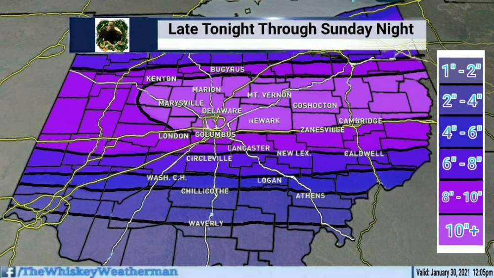
Models are averaging out around 3-4" tonight. Should be a nice event for the area down here. That should be enough to close most schools.
-
 1
1
-
-
The ice map doesn’t paint a pretty picture with this one. Yikes!! Right on the edge.
-
This looks decent now for here. Was expecting this to be mostly an I-70 special. Looks like we might get a little more from this.
-
I like it so far. I’d love it for a 30-60 mi shift South. Nickel & dime events so far this season.
Next Saturday will break the 711th day since we’ve had single digit lows. All time record. As always, we’ll be cutting that close.
-
13 minutes ago, ILSNOW said:
3rd time is a chime put it in 2/8-2/9 topic
the simple answer is, there are way too many short timeframe threads. Might as well start with 5-7 day spans.
-
11 hours ago, MIstorm97 said:
Going to be a bad time being an outdoor essential worker coming up

In my mind, it's just cold. If you get coated in water and it turns to ice, you actually feel warmer.
COVID is the worst thing to deal with. I spend more time now with a respirator on than I have in the last 20 years. -
5 minutes ago, Chicago WX said:
Where are we going to put all this snow?
I'll gladly take additional inches of snow down here. Still down -4.8 for the season.
-
1
-
-
We talked about this at work during last shift change. We are guessing April or May if things continue to drop, before some normalcy returns.I’ve had both rounds of Moderna vaccine. 2nd round was worse, feeling fatigued and sore joints for about 18 hours. Then it was over.
-
3
-
-
We got 2" last night, Maybe another .5" overnight before changing to rain. We'll see what the backside adds to this tonight.
At the height, with the heaviest bands, it was snowing like crazy. That was around 2000-2030hrs EST Saturday. It was definitely interesting driving to get home.
-
1 minute ago, dilly84 said:
Well we'll see. I'm going by nearly every model.
I hope you’re right, I’m just not too optimistic on that. I know every model does a poor job with the WAA.
-
14 minutes ago, CoachLB said:
Idk who he is. But he’s all in lol.
Too much Whiskey. Must be clouding his thoughts. There’s no way SW OH sees that big of a difference over a few counties. This isn’t one of those types of events.
-
1
-
-
Winds have shifted to the SE here. Just waiting on the warm air. If it goes too far North of us, it’s going to cut down on those higher totals in West/Central Ohio.
-
1
-
-
19 minutes ago, miamarsden8 said:
Reading through these forums, it's depressing moving from the Western Illinois University area, where we see at least some weenie number from time to time, to the Cincinnati metro area, where we're riding the line between 2 and 6 inches. Can we get a 20 mile south Euro shift?
Doubtful, but I can hope.
I’d just be happy if the low would track from St Louis along 64. That should keep more of it snow for us and less threat of the WToD.
-
24 minutes ago, Stevo6899 said:
To be fair, climate doesnt support snow and snowcover as much the further south you go towards cincinatti. But yea people need to put things in perspective before they complain about the lack of snow. I live 40 miles north of detroit and I don't think ive had more than 3 inches in a 24 hr period this winter, and it happened maybe once last winter in the early november snowstorm. Kinda rare this far north. The lack of big snows the past 3 winters is frustrating but it happens and we had a good run prior. Ive learned to be more happy for those that cash in on snow. Good karma.
While that may be true, we are down on average winter snowfall by 8” right now. So, we didn’t get much of a winter last year and this year is worse than that.
-
11 minutes ago, Gino27 said:
I feel like I've made out like a bandit in Union county. Clock keeps ticking for most of the state.
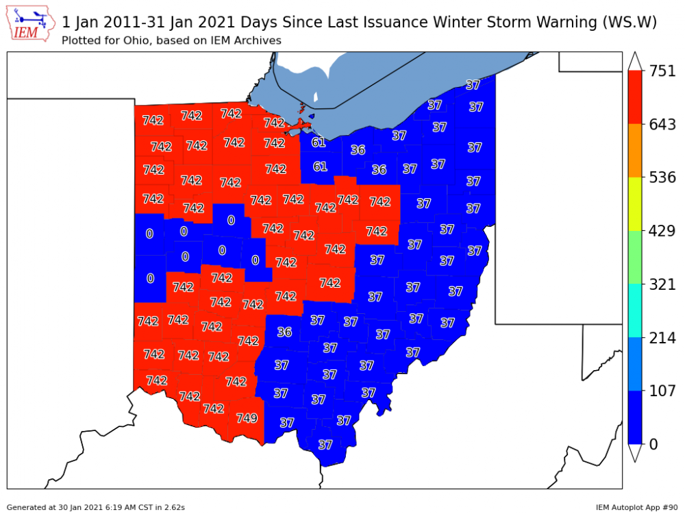
I’m in the clock keeps ticking range. 742 is also the number of days since we have seen 2.5” of snow at CVG in a 24 hour period.
I watch people complain on here about not getting as much snow as they want. I laugh and I think “you really have no idea, what a lack of snow is.”
-
1
-
-
4 hours ago, Gino27 said:
So much boom and bust potential here with the unpredictability of the warm tongue. I feel for the NWS.
I expect the warm tongue of death here. The models always underdo the warm air push.
-
2 hours ago, Gino27 said:
ILN backtracking with totals. Looks like my 741 day no WSW streak will survive.
I think I may beat that. The likelihood of any WSW down here is extremely low, unlike our chances at going more than 741 days with no more than 2.5” of snow in a 24 hour period.
-
Euro looks good to me. Today is the 740th day since we have not had more than 2.5” of snow in a 24 hour period.
-
 3
3
-
-
1 minute ago, Hoosier said:
I am going to be honest with you. You kinda didn't make a great first impression with your posting style here. I don't think I am alone in that assessment. And now that you have a met tag, your posts should tend to be of higher quality than the average member. The standard is elevated for folks like you given your larger base of knowledge. You can help turn around how you are perceived by not getting into silly fights and improving your level of posting.
Do you have a tag for weather whacker status? If so, I’ll take that... lol
-
2
-
 2
2
-
-
5 minutes ago, zinski1990 said:
I'd settle for at least 3 at this point lol.
I’d go for 2.5, since that might trigger a Watch. It’s been 720+ days since we’ve had more than 2.5” fall in 24 hrs.
-
1
-
-
Another 2” run for the Tri-State. A heavy snowfall is becoming an extreme rarity around here.
-
4 hours ago, OSUmetstud said:
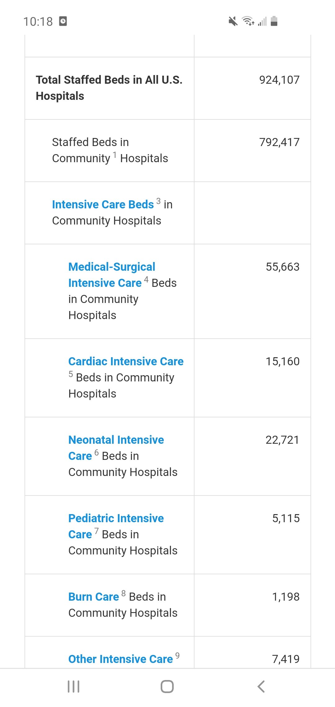
I think the choke point is intensive care and not regular hospital beds.
https://www.aha.org/statistics/fast-facts-us-hospitals
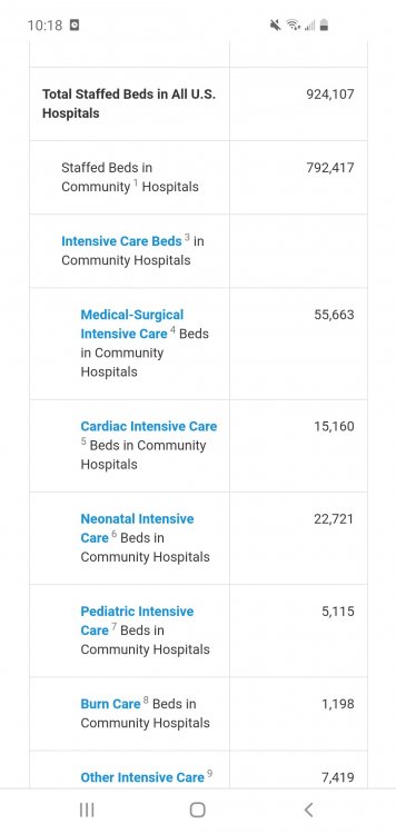
It’s not. The choke point is when you overcome the hospital or it starts reaching capacity. Currently, area hospitals here are about 80-85% full. That’s not a common number for this early into winter. That’s a number in January-February during the height of flu season.
It’s not just ICU beds, because every hospital has some people in it who are COVID but haven’t reached the need for ICU intervention, or are bad enough to need care but not need ICU level care.
When you are overcoming local resources and there is no more room when it becomes a problem. There is a trickle-down effect from the start of illness, depending upon the severity of the individual. The more that have moderate to major symptoms, the more strain that is applied to the local healthcare system both pre-hospital (EMS), hospital, and post-hospital. This isn’t a one shoe fits all type of scenario. It can be drastically different across different geographic and socioeconomic areas.
-
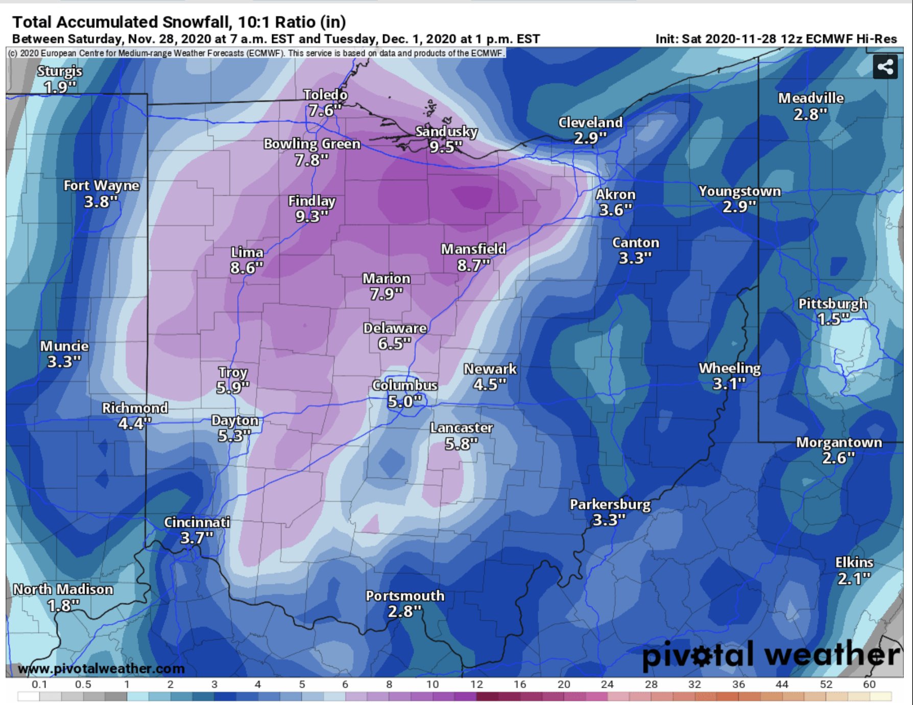
Just now, vpbob21 said:
I'll take the under on that 9.5" that map shows for me. My feeling is that areas near the lake will be lucky to see anything measurable.
Maybe better luck with the lake enhancement on Tuesday?
-
Euro is weaker and phase is late. Much lighter accumulations for much of Ohio.

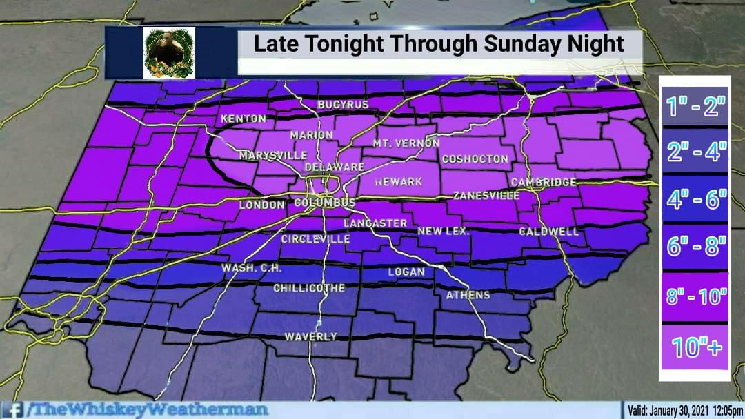

Feb 7th-9th event
in Lakes/Ohio Valley
Posted
Starting here with a little bit of sleet.