

Cashtown_Coop
-
Posts
3,380 -
Joined
-
Last visited
Content Type
Profiles
Blogs
Forums
American Weather
Media Demo
Store
Gallery
Posts posted by Cashtown_Coop
-
-
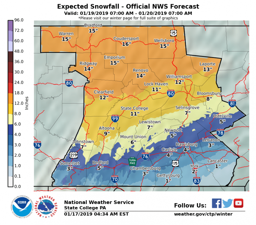
Round 1 was 1.1”
-
4 minutes ago, 2001kx said:
When i see your avatar i always thinks it a POV of you pissing.
Trouser Trout?
-
0.9” so far
-
2 minutes ago, JTrout said:
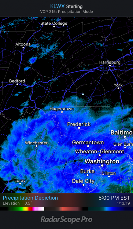
The band that had the special weather statement issued, now has some meat to it. Has it performed for anyone? I go stuck at work(Lancaster) its not here yet.
Picked up 0.5” in a hour

-
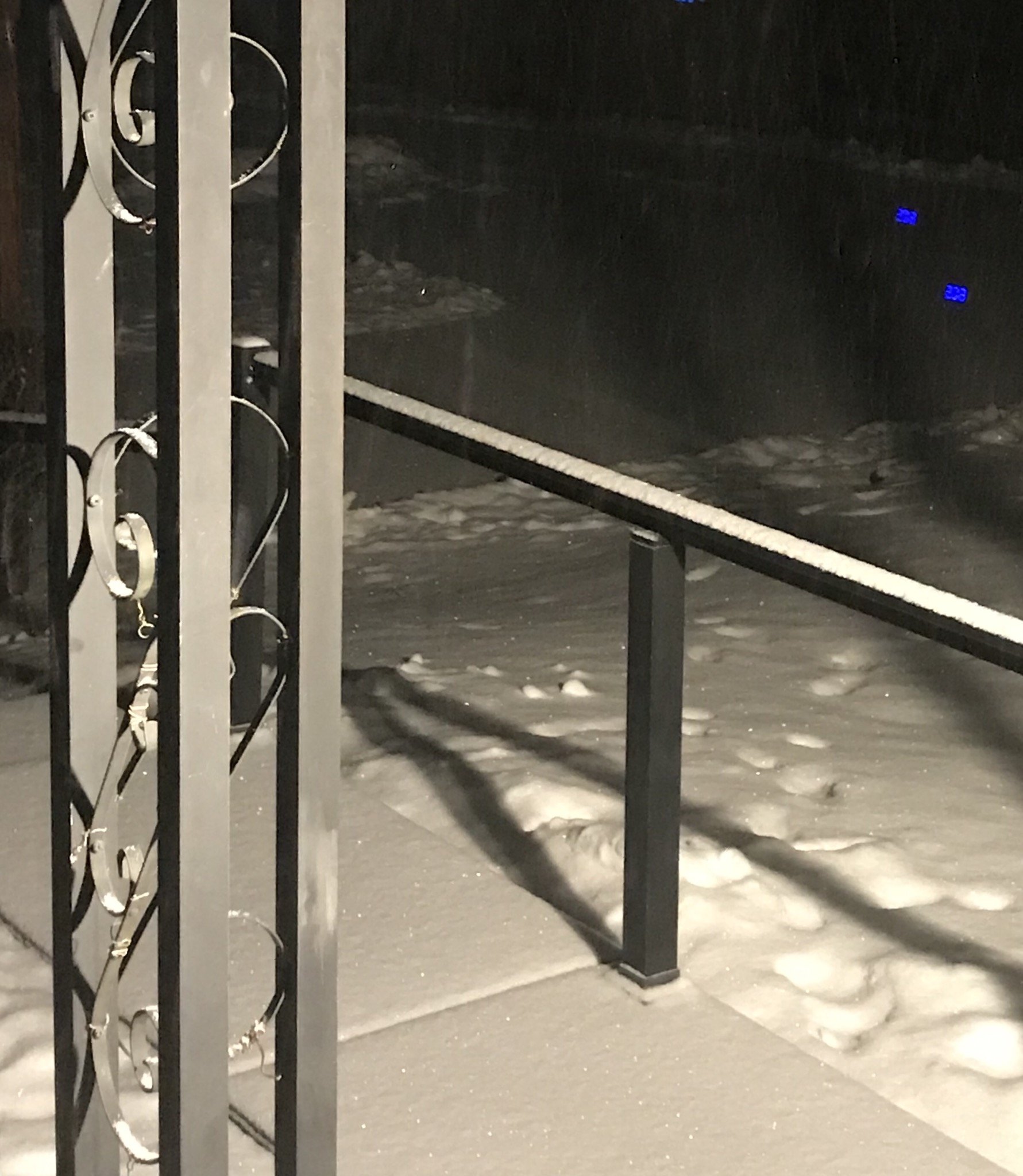
Steady snow started here around 5.
-
Just now, pasnownut said:
Wierd i know, but I'm fine w/ sleet-anything frozen as long as we can avoid plain rain.
Agreed 100%. After the rapid freeze, the snowpack left will lock in and stick around
-
3 minutes ago, Superstorm said:
With his focus mainly on Lancaster County, I have to lean more towards his outcome.
I think we get a couple of inches of snow than a brief period of freezing rain and sleet. Then it’s an inch plus of rain.
CAD looks very underwhelming on models (especially GFS).
.I agree that models may not show a cad signature but sometimes it’s best to use climo instead. LWX does a great job with this in their morn disco.
-
1 minute ago, Itstrainingtime said:
One thing I can say with certainty is Horst is NOT following the GFS. In many, many years of following him I've never once heard him write or talk about the GFS. The only model he ever mentions is the Euro and that isn't often.
I'm sure he's basing his forecast on what HE sees happening PLUS our climatology. Models to him are probably nothing more than guidance to consider.
I don’t follow him personally. Does he only forecast for Lancaster County or for all the LSV?
-
4 minutes ago, Itstrainingtime said:
Horst: No changes...
He must be riding the GFS
-
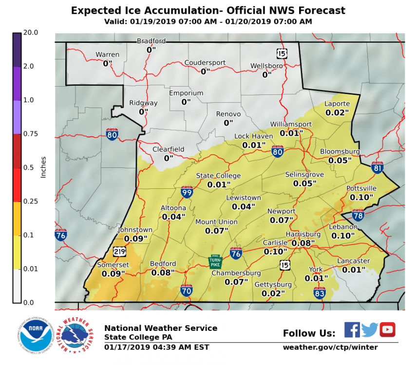
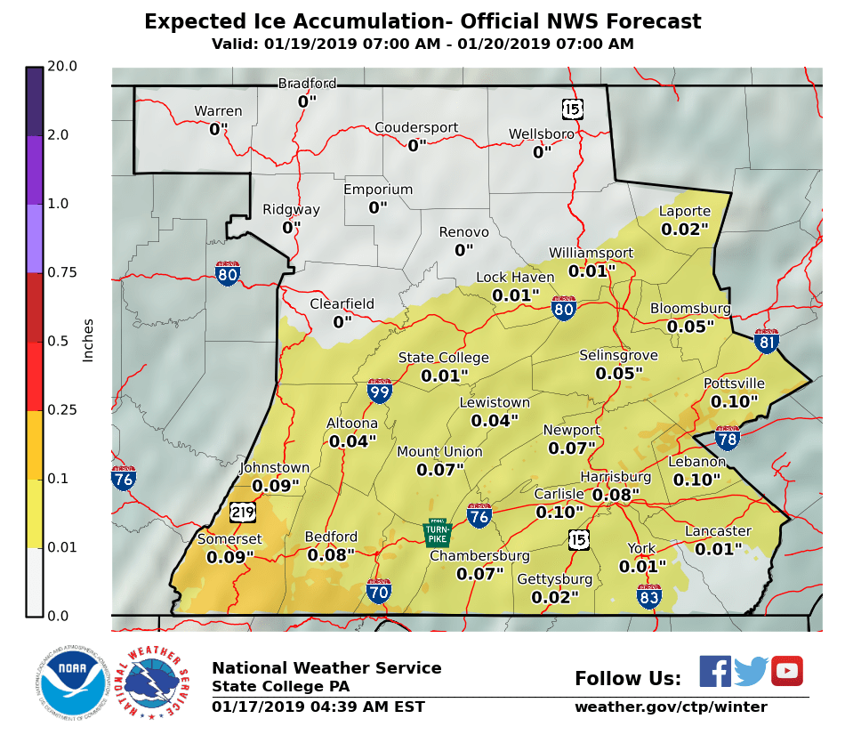
So the forecast for me is 1” of snow and 0.02” of ice. I’ll take the over
-
10 minutes ago, Superstorm said:

.Can you post the ice accum
-
-
Snow to ice to backend snow to arctic front
Um yes please. #Glacier
-
 1
1
-
-
MA crew saying west of Frederick never gets above freezing.
Freezing Rain may become a concern
-
13 minutes ago, MAG5035 said:
We seem to be faced with this type of scenario at least once or twice a winter.. a moisture laden storm system approaching from the MS and OH Valleys with the potential for significant winter impacts, where eventual track is key to whatever wintry or non wintry scenario we end up with. Without much Greenland or Canadian blocking available, this thing can cut it if phases early/too much.. which makes it a touchy setup. Thus, I'm pretty surprised at the specific details being thrown out by forecasting sources at this point of the game.. be it playing with D5 snowmaps showing 20-30+ in the viewing area, NWS discussion throwing out actual numbers in the long term section for this storm, or stating LSV is getting a big rainstorm. None of those things are anywhere near a certainty right now. I've been approaching this storm as of the variety where winter impacts are likely, but specific details are not going to be resolved for another couple days.
With all that said, even with the scenario where the low cuts just west or through PA... there is likely going to be front end wintry issues to be had in the form of front end snow and ice. Not the most ideal CAD setup but it's certainly workable with plenty of cold available and mid-late Jan climo on our side. The center of high pressure is modeled above MN/upper lakes, but the high pressure sprawls across the rest of eastern Canada. I find it unlikely right now that anyone in our subforum would see a straight rainstorm from this whether it cuts or not. Overnight model runs seemed to start coming back a bit from looking decidedly more wet yesterday so we'll see if they start getting under PA more. If the low pressure does skirt underneath most of PA or secondary development to the coast occurs this will be a significant snow and ice storm for most if not all of the subforum.
Couldn’t say it any better
-
10 minutes ago, bubbler86 said:
Borderline Hec's or top of the line MEC's for Northern and Western LSV. Uncanny how the storms always know where I81/I78 is as to contour lines.
Another tick south and we’re all in the game.
-
2
-
-
2 minutes ago, pasnownut said:
arent you halfway there yet....hehe
you need to change your name to "Jackpot"
13.2” ytd. I’ll put the dollar sign in place of the S
Ca$htown. Fixed
-
 1
1
-
-
Just now, pasnownut said:
Yeah, I've had a couple as well. I'd just tell them to "buckle up buttercup".
")
We all know we may not be on the right side of the snow fence for some, but looking at the back half of the GFS says opportunities will be frequent and IF....IF we hit them right, we could see snow totals like 95-96/09-10. Man I sure hope so.
I’m holding you to this. 90” or bust
-
2
-
1
-
-
Im calling it.
3.7” accum
.23” liquid
brings me to 13.2” ytd
all and all I feel the models did a good job with this one.
-
5 minutes ago, bubbler86 said:
Yea it is so hard to tell with this types of snow...it looks like it is charging in then loses support and dries up quickly. Seems it is snowing again in Cumberland and Adams county.
Dry air winning here. Just a few stray flakes.
-
Another bump or two, us southern guys might see a little more snow.
-
Period of mod snow last 45 min. 3.7”
-
2 minutes ago, Itstrainingtime said:
Flurries have just returned here.
You are correct about Harrisburg hitting -22. I remember that clearly. What I don't remember and what I'm curious about is how low did Thomasville get. Have to think they approached -30.
Good question for THV. If it was a calm decoupling night then it prob got that cold. If it was windy it may have stayed up closer to -22 or higher. The coldest I’ve recorded since starting Coop here in 2008 was -10 twice.
-
4 minutes ago, Itstrainingtime said:
Looks like snow is rapidly expanding north towards and into the LSV as Cashtown and Bubbler have already mentioned.
It’s a steady light snow accum .1” to .2” / hr stuff. Really adds to the mood
As far as that cold, holy cow! I remember that week of 1994 as a kid. We were off the whole week and I remember my dad telling me it was -24 outside. I think Harrisburg hit -22 which is still their all time low


Central PA - Winter 2018-19
in Upstate New York/Pennsylvania
Posted