Cashtown_Coop
-
Posts
3,380 -
Joined
-
Last visited
Content Type
Profiles
Blogs
Forums
American Weather
Media Demo
Store
Gallery
Everything posted by Cashtown_Coop
-
This type of pattern is shaping up to be running the heat to switching the AC on, wondering what happened to spring. No window opening temps.
-
Weather World 12 days trends was nothing but cold air and much below normal temps. Really cold around mothers day
-
Me either. I wanted to follow up on that. Looks like Aaron Tyburski was the met who wrote this near term which also happens to run the coop program.
-
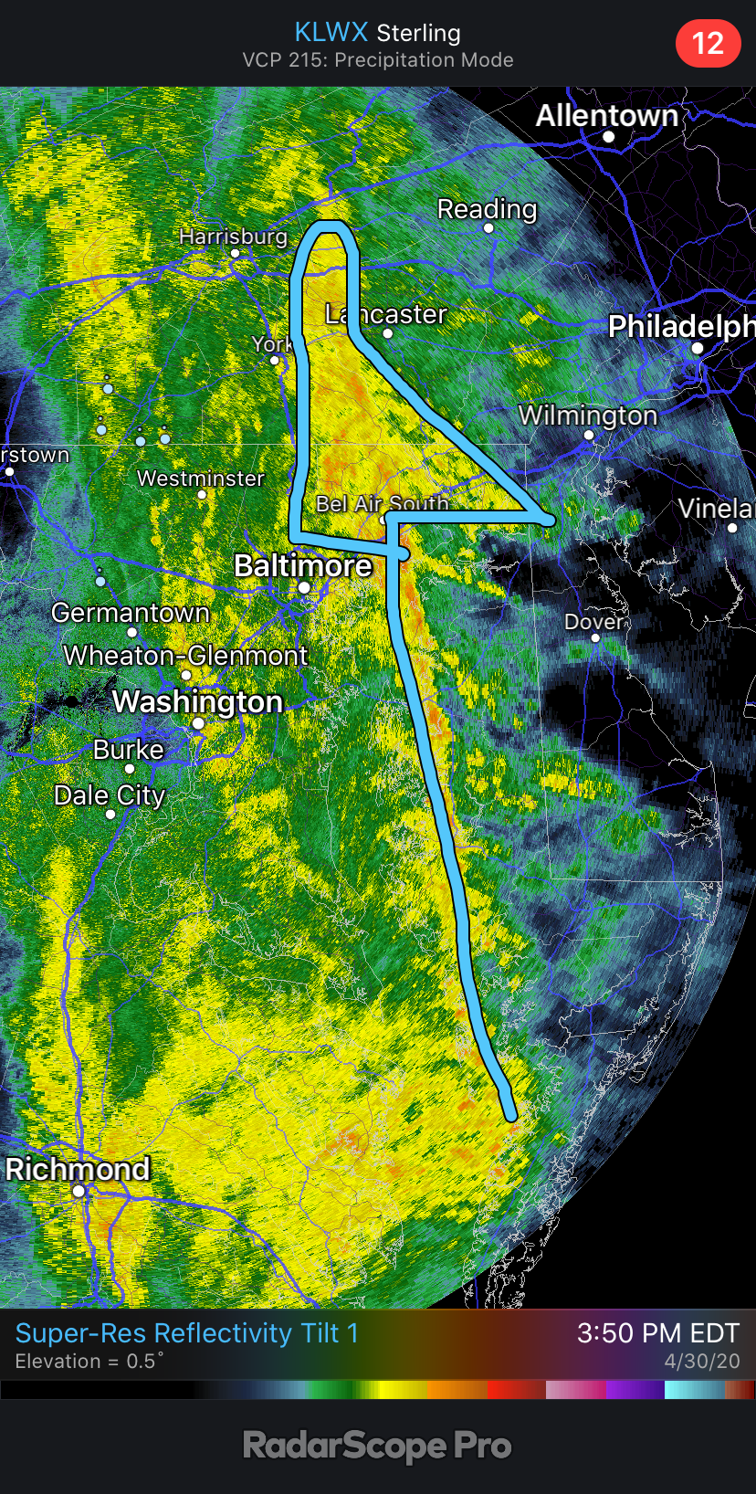
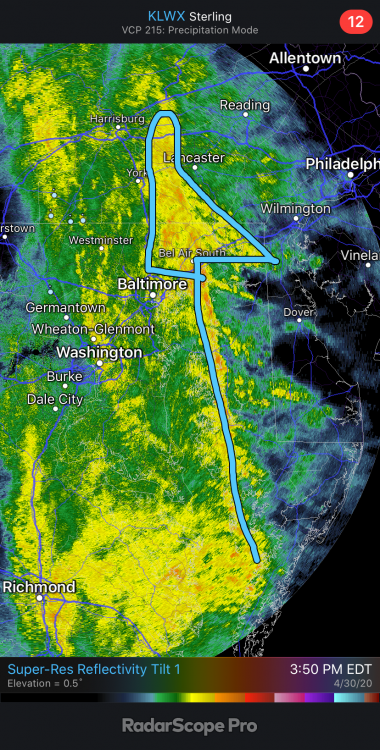
I did see this from ctp disco yesterday: Observed PW (1.36) is also easily in the 90th percentile for this time of year and not far from the maximum. What this means is the rainfall in our eastern zones is highly efficient, with radar under-estimates noted. KCCX radar was underestimating rainfall amounts significantly earlier today, and a switch to Summertime Convective and then Tropical Z-R was done to try to more accurately depict upcoming, and storm total rainfall across our eastern zones.
-
It’s still way off even with that time frame.
-
Why put a map out if it only covers a percent of the event. (Scratches head)
-
This map misses the mark for my area going up through Perry. Many 3”+ reports
-
This won’t bode well for Adams down the road for the same scenario you’re describing. We are right on the 50 cases per 100,000 bubble but stuck in between two counties with higher rates. I think Fulton has like 5 confirmed cases. Def is a flaw
-
Sat is packed. Sunday might turn out wetter than forecast so we’ll see
-
Only during check in. Then each golfer is issued their own cart. The cups are also pulled up above the green so the player will never have to touch the cup or flag. No rakes, ball washers etc on course as well. There are other safety measures too add but this is the basic set up like to add, many players were wearing masks or bandanas
-
Yeah I’d say. Pushes everything back for sure. We had around 40 golfers so far today. Tomorrow is booked solid
-
That’s it. I would have figured Perry, Fulton counties etc would have made the cut.
-
Measured 3.07” officially. Yard is a swamp
-
I maxed out on the axis. Headed out to get official measurement now
-
Back edge is racing NE. Guessing another hr or so before dryslot hits Lancaster
-
Nugget Nectar is my fav. I really like all kinds of beer. Imperial Stouts are good as well
-
I think it does. Also aids in severe as well. Just an observation over the years. @Eskimo Joementioned something about this years ago as well
-
I’m not picky but since your buying I’ll put in for an IPA
-
Enhancement from the bay. The pwat prob jumps up
-
Arrow is already there. You didn’t need to draw it. That’s pretty crazy
-
It has a little but the back edge doesn’t have the bite like earlier. Somewhere around .15”/hr
-
Flood warning issued from a line Gettysburg to Williamsport. VP2 is reading 3” on the button
-
Not taking that bet. Same band that went through here
-
Over 2.50” here and things are saturated for sure. Flood warning Northern frederick county just to my south
-
That’s when the investment really pays off. Watching the deform band