

Snowlover11
-
Posts
8,946 -
Joined
-
Last visited
Content Type
Profiles
Blogs
Forums
American Weather
Media Demo
Store
Gallery
Posts posted by Snowlover11
-
-
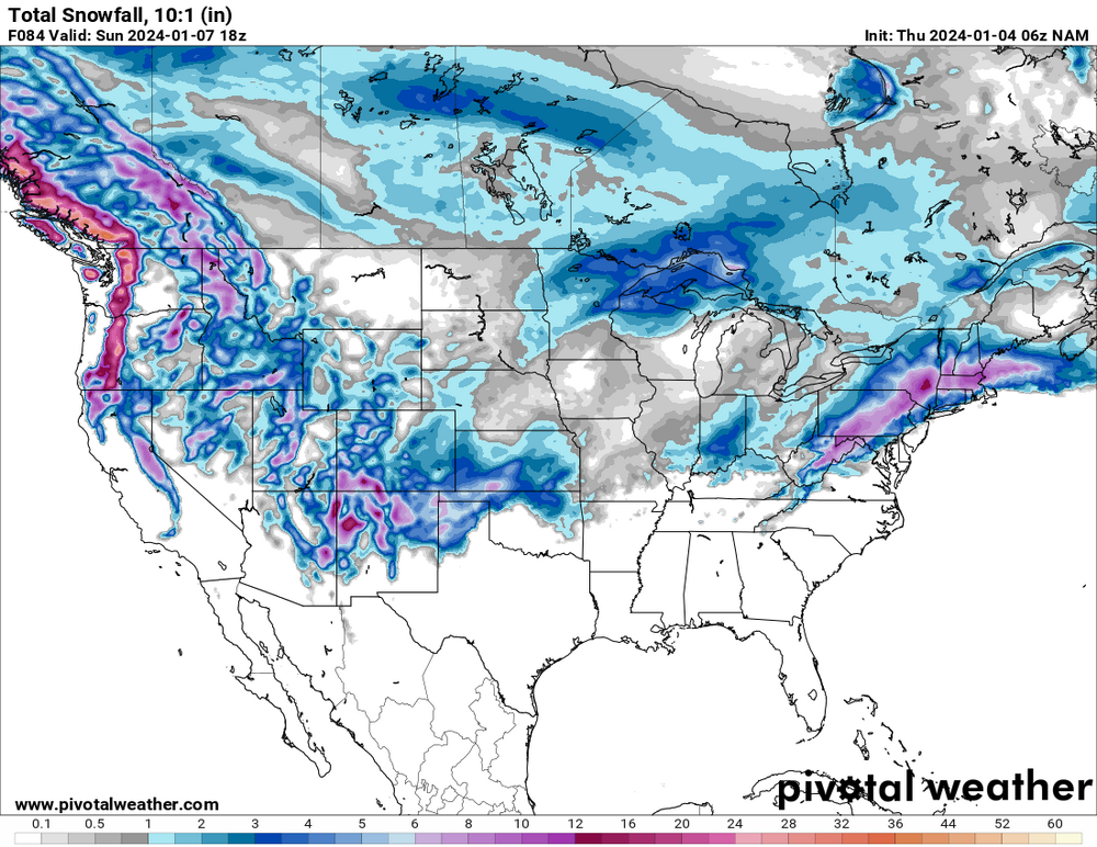
3 minutes ago, RU848789 said:
That's incorrect. Plenty of snow "falling" - it's just not clear how much of it will accumulate with 34-35F surface temps; during the thump part, NYC looks to be below 32F (barely) for the whole column, which is good. So verbatim there will be snow and if we can avoid a warm nose aloft (who knows?) I think a few inches (not the 4.3" on the 10:1 map below) is likely - as per the GFS, not a forecast.

nyc is not receiving 4.3”, cant rely on clown maps specially in this setup. thats also on 10:1 ratios.
-
 1
1
-
-
P.S stop the bricking weenies! the coast will have there shot down the road. onto the next one! it will snow again I promise!
-
2
-
-
5 minutes ago, BoulderWX said:
Most models had me in the jackpot 2-3 days ago and I said it would definitely change. It did. Jackpot moved about 40 miles north and northwest of me. So while the snow line has stayed close to Bronx, accumulations have gone way down for borderline suburbs like myself.
you should be good in boulder, co.

-
1
-
-
lmao. nam is so violent with run to run. but it is starting to get ugly.
-
4 minutes ago, vegan_edible said:
id be stoked if we cash 5-7 in wp, i remember the late feb event last year we had like 5 inches while i think the city got diddly squat
will definitely be a difference from nyc to white plains, I see more 5” but it all depends on precipitation rates/intensity. see if models continue the trend with the 2nd half of this storm i can see it.
-
1 minute ago, jm1220 said:
Up near Ramsey where I-287 merges into I-87 will probably be fine. That area where the elevation lowers and I-87 turns east into the Tappan Zee might be the area where you start seeing under warning snow amounts.
the tappan will be the dividing line imo. sharp cut off from there and south. this is where o can see nyc getting 1-2” northern bronx 3-4” white plains 5-7” and nw of the hudson passed the bridge warning snows.
-
-
-
4 minutes ago, TriPol said:
Let’s say it together now for nyc and the coast: Storm cancel.
its actually gotten better for nyc and even the coast. so not sure what you’re seeing.

-
1
-
 1
1
-
-
wow.. euro cold af. keeps nyc snow, incoming MJO post
-
2
-
1
-
-
5 minutes ago, ILoveWinter said:
RGEM wasn't terrible for the coast but yes needs more support to be believable. Hopefully the Euro shows some improvement in less than an hour though it's prob a long shot.
um RGEM hardly shows much at the coast? you gotta be NW of white plains, etc for anything over 3”
-
well good night irene on this one, got ugly fast. even for areas north and west of the city(20-25 miles)
-
1
-
-
-
8 minutes ago, Brasiluvsnow said:
Anyone besides me waiting on the Euro ?
im up, currently at work. honestly hope the euro delivers!
-
2
-
-
7 minutes ago, mikeysed said:
RGEM is warm. Least amount for those on the borderline spots immediate tri-state
warm as hell. even immediate north and west areas get hosed. lower westchester, extreme ne nj, rockland.
-
euro says you dont get crap anything till your well north of 287-I-84
-
2
-
-
the city is playing with fire here so far during 12z model suite. 1-3”-2-4” but at this point im sure it would be big news since they gone nearly 700 days without an 1” recorded.
-
3
-
-
1 minute ago, vegan_edible said:
gfs in a bit stronger than last night and keeps the fun going with some light-er snow all day sunday. lets hops the cmc and euro show something a little more amped and we find a happy middle ground. im hoping for a solid 5-6inches in white plains. i do wonder though since i've only lived down here for a year and half and experienced snow twice in this region, would y'all consider white plains a "coastal" area?
yes and no, white plains is obviously the 287 line which in most borderline storms stays snow alot longer than even the “lower” section of westchester/bronx. if your near or NW of of 287 you should definitely be able to cash in several inches here.
-
4
-
-
we aren’t getting 10:1 ratios, so you can shit can that idea. probably more so 6:1-8:1.
-
18 minutes ago, Snowguy66 said:
Says captain freaking obvious
.no reason to be a douche canoe.
-
1
-
-
foggy as all hell outside
-
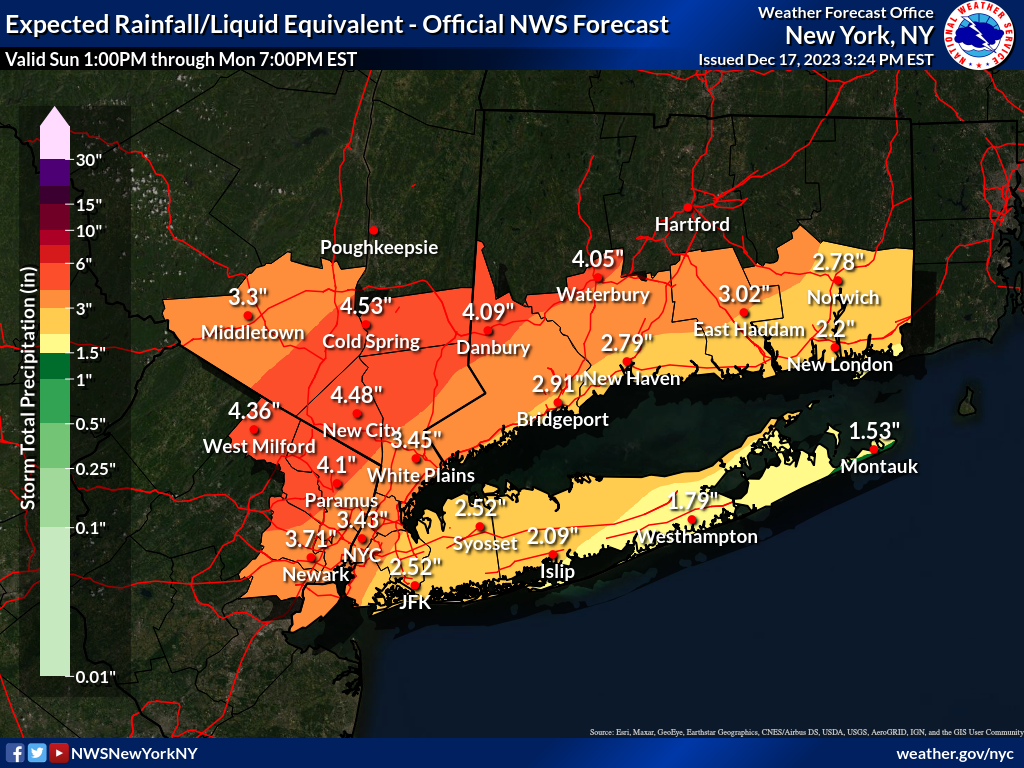
1 minute ago, hudsonvalley21 said:
Upton’s latest QPF map has ticked up a little

yeah they have me getting 2-3” tonight followed by another 1-2” tomorrow.
-
1
-
-
raining decently here already hours before the main show.
-
nam dumps over 5” might need to get the rowboat out and hopefully the winds blows me to safety.
-
1
-
Two Mdt to high impact events NYC subforum; wknd Jan 6-7 Incl OBS, and mid week Jan 9-10 (incl OBS). Total water equiv by 00z/11 general 2", possibly 6" includes snow-ice mainly interior. RVR flood potential increases Jan 10 and beyond. Damaging wind.
in New York City Metro
Posted
rockland coming into westchester gets bad after 7am. I come home from yonkers to nanuet at that time. it starts building up from the bridge to nearly exit 14. which is roughly 5 miles.