

Snowlover11
-
Posts
8,946 -
Joined
-
Last visited
Content Type
Profiles
Blogs
Forums
American Weather
Media Demo
Store
Gallery
Posts posted by Snowlover11
-
-
state of emergency for nj starting 5pm tomorrow
-
kinda thankful we didnt get the heavier totals here, rockland is a shitshow when we get heavy rain as is. wednesday’s morning commute will be outrageous all over.
-
25 minutes ago, MJO812 said:
The coast is going to get hammered tomorrow with wind gusts over 60 mph.
They want you on harbor patrol tomorrow night

-
 1
1
-
-
welp that’s a wrap, nice to see what snow looks like again!
-
 1
1
-
-
4.2” here, additional light dusting
-
snowing nicely outside, just cleaned the car off, should of waited
-
either i have flipped or just extremely light. but 3.8” on the board.
-
1
-
-
-
roads are dog water here in rockland, can see 287 from my house and traffic is moving pretty slow.
-
mod snow, 1” to 1.5” on the ground? havent gone out to check but by eyeballing between that range.
-
 1
1
-
-
light to borderline moderate snow now.
-
light snow, starting to dust the ground
-
-
fu dry air, still high and dry here in rockland.
-
8 minutes ago, Brasiluvsnow said:
Currently in New City Rockland County 33 / 12 with nothing falling besides expectations

same here pal
-
1
-
-
got a friend who lives in ellensville, NY he’s gunna get plastered with 8-12”+
-
-
well the only good news here is that the precip should come in like a wall, so we should go from nothing to a moderate/heavy precip rate fairly fast. thats when you hope we can overachieve for boarderline areas.
-
-
6 minutes ago, MikeS said:
Upton just cut my totals for Saturday Night from this morning..went from 3-7 inches to now 2-4 inches
same here went from 3-7 saturday night, additional 1-3” sunday
now to 1 inch or less saturday followed by 2-4” saturday night, additional less than 1 inch sunday so 3-6”
yet im under a warning for 5-9”

-
wow upton with a warning here 5-9” that’s bullish
-
euro isnt pretty till your northwest of rockland/northern westchester, etc
-
honestly just curb your expectations if your expecting 1-3” expect 1” if your expecting 2-4” expect 2” and so forth.
-
1 minute ago, RU848789 said:
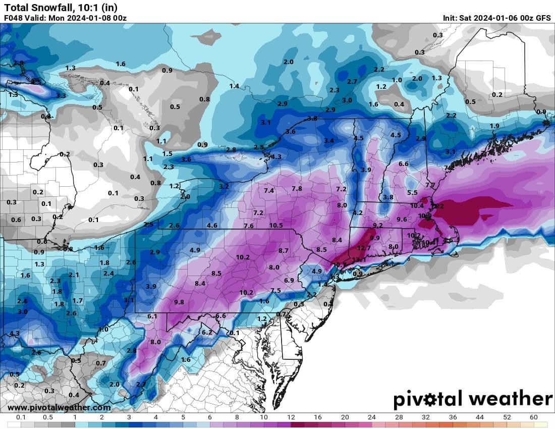
I know, I said that. I included the 10:1 map, as that shows how much snow is "falling" to illustrate that it's not "mostly rain." Kuchera shows about 2" and I think that's underdone on the model verbatim, as column temps are below 32F on the model until the surface and given decent intensity (once snow starts accumulating, subsequent snow is not affected much by above 32F surface temps, as the actual surface is now 32F snow/slush), even NYC will accumulate maybe 2-3" from that 4.3" of snow falling. That's my informed opinion. I'm not a met, but I guarantee you a PhD in chem eng'g and 30+ years of doing hard science including a lot of work in heat transfer and physical chemistry phase transitions (crystallizations and melting - with several patents in the field for organic molecules) and a lifetime of observing high intensity snow accumulating when people said it wouldn't (think most March/April storms), means a little bit. This is not really a "meteorology" question (assuming the model is correct and no warm nose aloft, just above 32F at the surface), but a physical chemistry/rate question.
my apologies i misread you’re point.
-
1
-
Two Mdt to high impact events NYC subforum; wknd Jan 6-7 Incl OBS, and mid week Jan 9-10 (incl OBS). Total water equiv by 00z/11 general 2", possibly 6" includes snow-ice mainly interior. RVR flood potential increases Jan 10 and beyond. Damaging wind.
in New York City Metro
Posted
the flooding is gunna be insane, especially north and west where they have a snowpack. plus another storm come friday night/saturday.