Thrasher Fan
-
Posts
1,399 -
Joined
-
Last visited
Content Type
Profiles
Blogs
Forums
American Weather
Media Demo
Store
Gallery
Everything posted by Thrasher Fan
-

January 25/26 Jimbo Back Surgery Storm
Thrasher Fan replied to Jimbo!'s topic in Southeastern States
12z GFS much slower with precip onset out to 78h -
January 25/26 Jimbo Back Surgery Storm
Thrasher Fan replied to Jimbo!'s topic in Southeastern States
FFC discussion. .LONG TERM... (Thursday night through Tuesday) Issued at 204 AM EST Wed Jan 21 2026 Thursday into Friday will have our first push of rainfall as a quick shortwave pushes through the main trough over the eastern CONUS. QPF amounts are expected between 0.5-1" over northern Georgia. the precipitations should remain in liquid form but some higher elevations of the North GA mountains may see some mixed precip Fri morning. No accumulations expected. Fri night into Sat morning will be the beginning of the main wintery precipitation. Saturday into Sunday we will begin to see the overall troughing pattern begin to dive south into the southeastern U.S. while the low pressure system currently off the Pacific begins to push inland. This setup creates an atmospheric river from the Mexican Pacific coast, across the entire southern U.S., and out across to the Carolinas beginning Fri afternoon. The timing of how this Pacific low pressure system moves is going to in turn factor into how long we are expecting potential impacts. Current timing has this system moving rapidly across the south states through the weekend and up the eastern seaboard and pulling out of GA Monday morning/early afternoon. Some things to talk about with this event. This is shaping up to be a potentially high impact event with moderate to major impacts. With this amount of model consistency in the overall setup we are gaining confidence that this could be a long duration event as well. With initiation as early as Saturday afternoon and wintry precip looking to extend into Sunday night/Mon morning. At this point we are confident that wintry precip will affect north Georgia for areas along and north of I-20. The area south of I-20 down to Macon and Columbus are a little more uncertain but models are consistently forecasting wintry precip for this area as well. A few factors into how much/what type of wintry precip we receive are the influence of the wedge expected to take shape and then how far north the front pushes. When it comes to the wedge, current thinking is that snow will be the main precip type for far north Georgia and wintry mix/freezing rain will become the main concern for the remainder of the north Georgia including the ATL/AHN areas. There is still a decent shot that we see this freezing rain transition to more of a snow event as we get into late Sunday and Monday but that is still uncertainty. Focusing on the probabilistic information for now. --> 40-50% chance for 0.5" or greater of ice accumulation through the weekend for the areas north of I-20. --> 25-30% chance for 0.75" or greater of ice accumulation through the weekend for the areas north of I-20. --> 15-20% chance for 1" or greater of ice accumulation through the weekend for the areas north of I-20. --> 30-45% chance for 2" or greater of snow accumulation through the weekend for the areas north of I-20. For now the main thing to focus on is being prepared for a potentially high impact event this weekend. We will likely see more changes over the coming days but please make sure you have a plan to endure this event which could include power outages. Once this system exits the area Monday, a good portion of north GA will continue to see impacts as Temps Mon are not expected to get to much above freezing. Any accumulations that linger will most likely continue through Tue when temps are expected to get up into the upper 30s to near 40. -
January 25/26 Jimbo Back Surgery Storm
Thrasher Fan replied to Jimbo!'s topic in Southeastern States
The run to run consistency on the 0z EURO 114h is like throwing darts at a dart board blindfolded. Pull your hair out insanity. More fun tomorrow. -
January 25/26 Jimbo Back Surgery Storm
Thrasher Fan replied to Jimbo!'s topic in Southeastern States
Indeed. Quite a war we have playing out here... -
January 25/26 Jimbo Back Surgery Storm
Thrasher Fan replied to Jimbo!'s topic in Southeastern States
Some minor, early on changes to the Euro out to 60. Let's see where this goes... -
https://x.com/MassachusettsWx/status/2013808206854709486?s=20
-
January 25/26 Jimbo Back Surgery Storm
Thrasher Fan replied to Jimbo!'s topic in Southeastern States
Nonsense model. I trust the ICON more than whatever that thing is spitting out. -
All due respect to the UKMET but that is a completely bogus run. Rebuild that model from scratch.
-
January 25/26 Jimbo Back Surgery Storm
Thrasher Fan replied to Jimbo!'s topic in Southeastern States
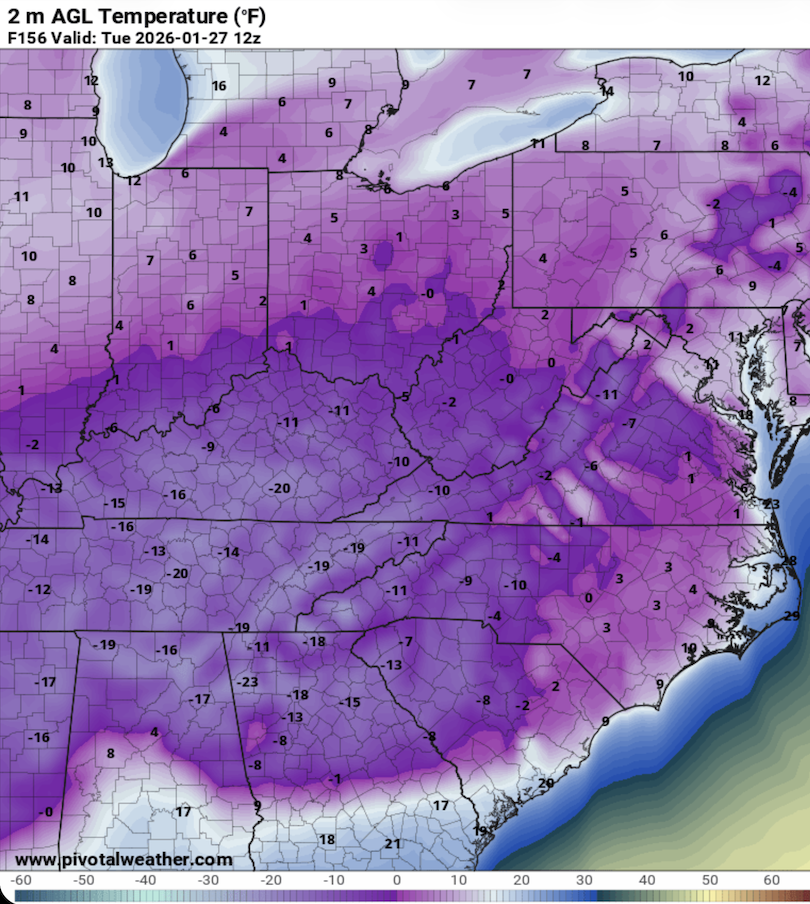
These are 7AM Est Tuesday temps as depicted on the 0z GFS. Not likely to verify but should provide a small glimpse into the blocking that is sliding into place.
-
January 25/26 Jimbo Back Surgery Storm
Thrasher Fan replied to Jimbo!'s topic in Southeastern States
Something to note on that 0z GFS run... https://x.com/MassachusettsWx/status/2013808206854709486?s=20 -
January 25/26 Jimbo Back Surgery Storm
Thrasher Fan replied to Jimbo!'s topic in Southeastern States


-
January 25/26 Jimbo Back Surgery Storm
Thrasher Fan replied to Jimbo!'s topic in Southeastern States
-
January 25/26 Jimbo Back Surgery Storm
Thrasher Fan replied to Jimbo!'s topic in Southeastern States
0z GFS no budging much from 18z. Blocking may be slightly stronger. Marginal change at best. 78h -
January 25/26 Jimbo Back Surgery Storm
Thrasher Fan replied to Jimbo!'s topic in Southeastern States
0z GFS running. Hold_on_to_your_butts.jpeg -
January 25/26 Jimbo Back Surgery Storm
Thrasher Fan replied to Jimbo!'s topic in Southeastern States
ICON holds serve. Maybe a bit stronger on the CAD but not much change. Onward to more serious models. -
January 25/26 Jimbo Back Surgery Storm
Thrasher Fan replied to Jimbo!'s topic in Southeastern States
Not much change out to 66h -
https://x.com/wxunfiltered/status/2013760698975744388?s=20
-
January 25/26 Jimbo Back Surgery Storm
Thrasher Fan replied to Jimbo!'s topic in Southeastern States
Not exactly for our region on this board but the GOAT has put out some Tuesday thoughts on the coming storm. https://x.com/spann/status/2013795951081644345?s=20 -
January 25/26 Jimbo Back Surgery Storm
Thrasher Fan replied to Jimbo!'s topic in Southeastern States
Been thinking about jburns today. He would be loving this week so much. RIP -
Everyone's favorite model kicks off the 0z suite soon. The cycle continues momentarily
-
Just trying to decide if I should capture some of this rain for the crops this summer.
-
January 25/26 Jimbo Back Surgery Storm
Thrasher Fan replied to Jimbo!'s topic in Southeastern States
Jimbo back surgery back on? -
So the 18z EURO actually amped the HP blocking while also running the storm right through it. That does not compute. Am I reading things wrong?
-
January 25/26 Jimbo Back Surgery Storm
Thrasher Fan replied to Jimbo!'s topic in Southeastern States
ZR has been consistent on the GFS for several runs now. Disaster.
-
I wonder what WilkesboroDude thinks about the coming storm?