Thrasher Fan
-
Posts
1,399 -
Joined
-
Last visited
Content Type
Profiles
Blogs
Forums
American Weather
Media Demo
Store
Gallery
Everything posted by Thrasher Fan
-

January 25/26 Jimbo Back Surgery Storm
Thrasher Fan replied to Jimbo!'s topic in Southeastern States
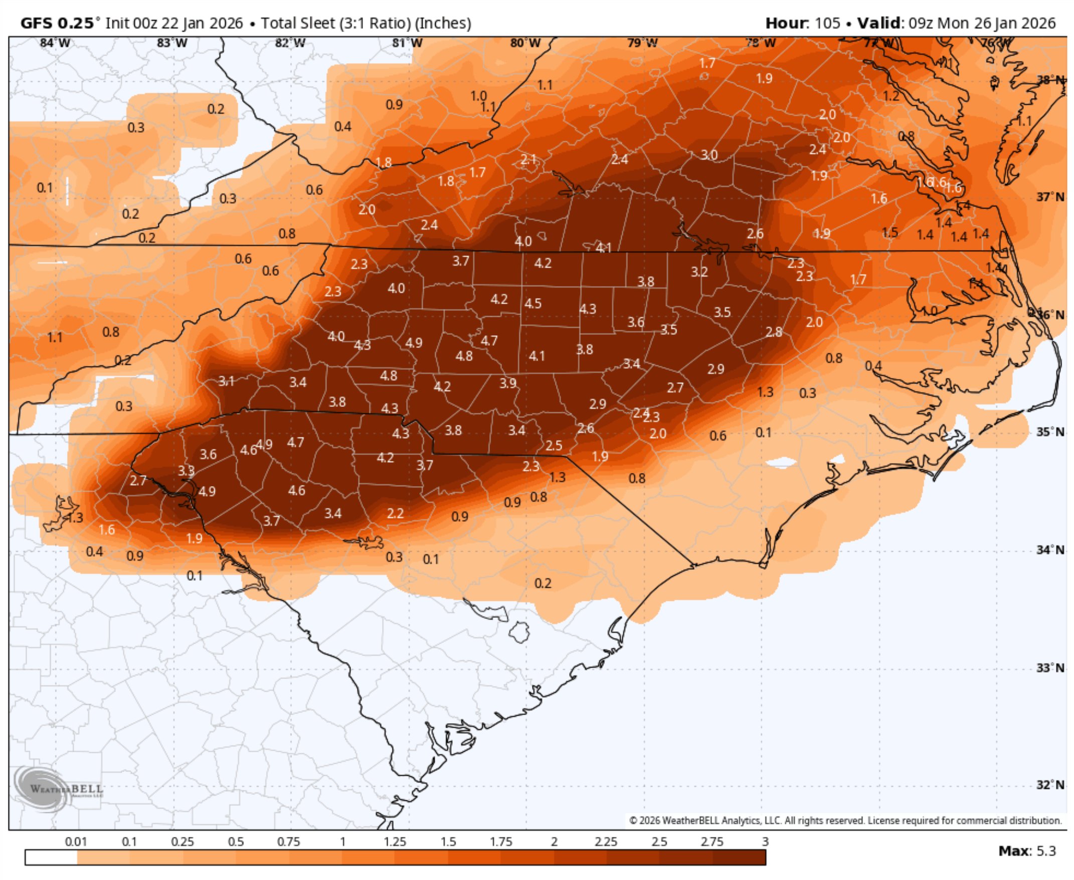
0z GFS slightly strengthened the blocking thus the CAD was a bit stronger that run. -
January 25/26 Jimbo Back Surgery Storm
Thrasher Fan replied to Jimbo!'s topic in Southeastern States
ChatGPT thoughts on 5 inches of sleet and how long it lasts.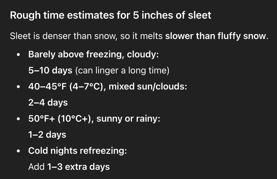
-
January 25/26 Jimbo Back Surgery Storm
Thrasher Fan replied to Jimbo!'s topic in Southeastern States
Epic.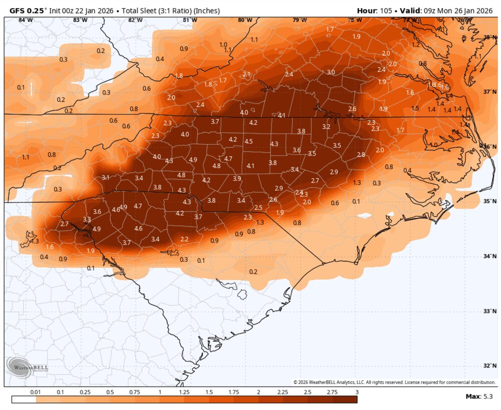
-
January 25/26 Jimbo Back Surgery Storm
Thrasher Fan replied to Jimbo!'s topic in Southeastern States
Pain.
-
January 25/26 Jimbo Back Surgery Storm
Thrasher Fan replied to Jimbo!'s topic in Southeastern States
Well that was odd. -
January 25/26 Jimbo Back Surgery Storm
Thrasher Fan replied to Jimbo!'s topic in Southeastern States
Almost copy paste from the 18z out to 60h. Moisture a tad slower. -
January 25/26 Jimbo Back Surgery Storm
Thrasher Fan replied to Jimbo!'s topic in Southeastern States
Hurricane season right around the corner! -
January 25/26 Jimbo Back Surgery Storm
Thrasher Fan replied to Jimbo!'s topic in Southeastern States
Bump -
January 25/26 Jimbo Back Surgery Storm
Thrasher Fan replied to Jimbo!'s topic in Southeastern States
Hugging a single model with known CAD identifying issues is certainly a choice. -
January 25/26 Jimbo Back Surgery Storm
Thrasher Fan replied to Jimbo!'s topic in Southeastern States
long range NAM always finding the good drugs. -
January 25/26 Jimbo Back Surgery Storm
Thrasher Fan replied to Jimbo!'s topic in Southeastern States
A note for tonight's disco... https://x.com/JeremyDeHartWX/status/2014163601712410877?s=20 -
January 25/26 Jimbo Back Surgery Storm
Thrasher Fan replied to Jimbo!'s topic in Southeastern States
Fake news I'm afraid. The heights are not great. -
January 25/26 Jimbo Back Surgery Storm
Thrasher Fan replied to Jimbo!'s topic in Southeastern States
ULL further west on 0z NAM. Could be good here... -
I guess Cheeznado doesn't visit this board anymore? He was usually a good source to follow in lead ups to a storm
-
January 25/26 Jimbo Back Surgery Storm
Thrasher Fan replied to Jimbo!'s topic in Southeastern States
Always wondered what they mean by “Flat Ice” . -
January 25/26 Jimbo Back Surgery Storm
Thrasher Fan replied to Jimbo!'s topic in Southeastern States
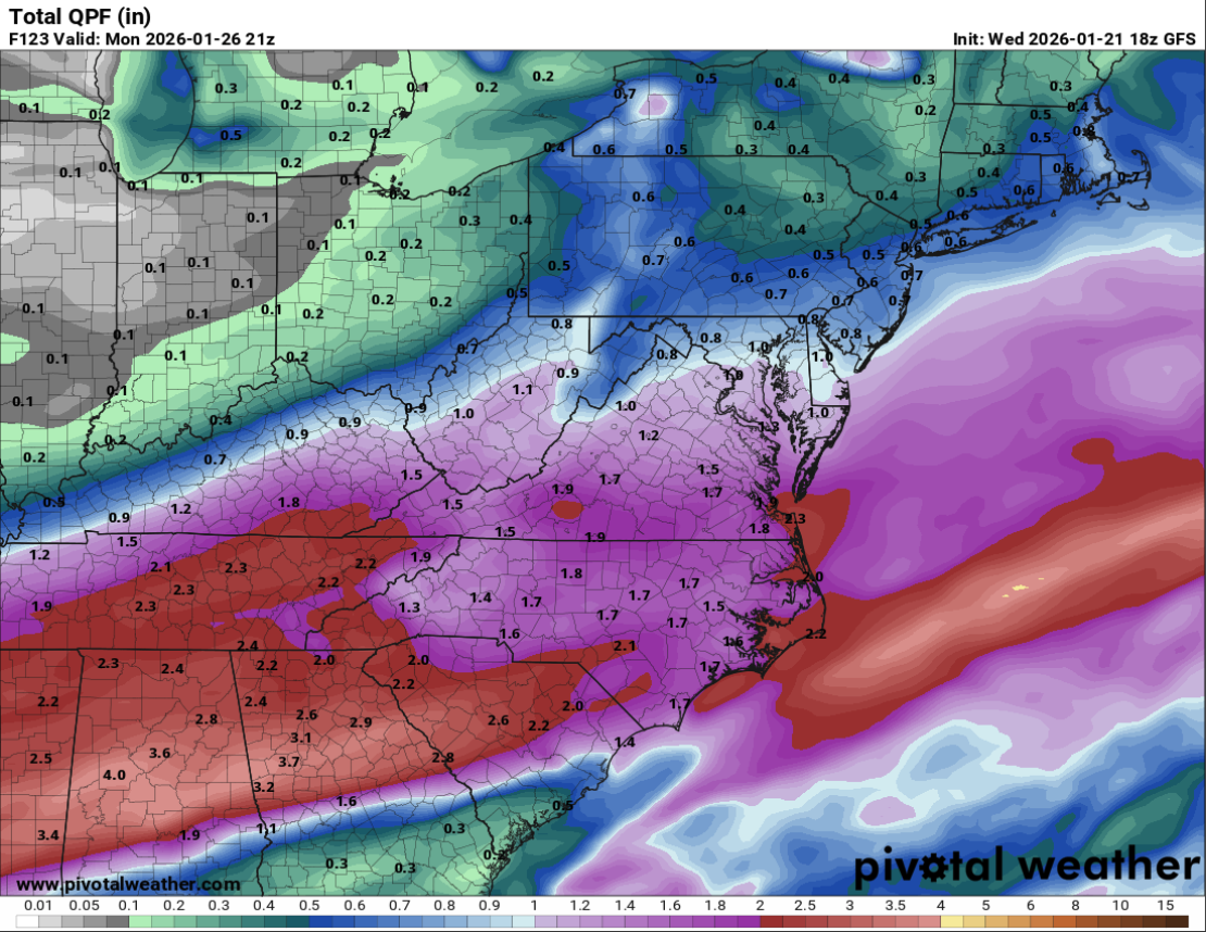
So much QPF to work with on that run.
-
January 25/26 Jimbo Back Surgery Storm
Thrasher Fan replied to Jimbo!'s topic in Southeastern States

-
January 25/26 Jimbo Back Surgery Storm
Thrasher Fan replied to Jimbo!'s topic in Southeastern States
Below is hour 90 of the 0z GFS and EURO. Both still not connected on the strength of the HPs to the north thus the difference in strengths of the CADs.
-
I think that would be everyone on this board.
-
The winter weather is snow only crowd can go ahead and just logoff at this point. Cluttering everything up with crying.
-
January 25/26 Jimbo Back Surgery Storm
Thrasher Fan replied to Jimbo!'s topic in Southeastern States
Euro has taken a dump. As in not running correctly. -
January 25/26 Jimbo Back Surgery Storm
Thrasher Fan replied to Jimbo!'s topic in Southeastern States
KFFC has played some cards... URGENT - WINTER WEATHER MESSAGE National Weather Service Peachtree City GA 1217 PM EST Wed Jan 21 2026 GAZ001>009-011>016-019>024-220800- /O.NEW.KFFC.WS.A.0001.260124T0600Z-260126T1500Z/ Dade-Walker-Catoosa-Whitfield-Murray-Fannin-Gilmer-Union-Towns- Chattooga-Gordon-Pickens-Dawson-Lumpkin-White-Floyd-Bartow-Cherokee- Forsyth-Hall-Banks- Including the cities of Dawsonville, Chatsworth, Blairsville, Gainesville, Calhoun, Dahlonega, Hiawassee, Dalton, Woodstock, Ellijay, Rome, Cleveland, Blue Ridge, LaFayette, Trenton, Jasper, Homer, Summerville, Fort Oglethorpe, Cumming, and Cartersville 1217 PM EST Wed Jan 21 2026 ...WINTER STORM WATCH IN EFFECT FROM LATE FRIDAY NIGHT THROUGH MONDAY MORNING... * WHAT...Heavy mixed precipitation possible. Total snow and sleet accumulations up to 4 inches and ice accumulations greater than one quarter inch possible. * WHERE...Portions of north central, northeast, and northwest Georgia. * WHEN...From late Friday night through Monday morning. * IMPACTS...Expect power outages and tree damage due to the ice. Travel could be impossible. The hazardous conditions could impact the Monday morning commute. PRECAUTIONARY/PREPAREDNESS ACTIONS... Monitor the latest forecasts for updates on this situation. Persons should consider delaying all travelSaturday and Sunday. If travel is absolutely necessary, drive with extreme caution. Consider taking a winter storm kit along with you, including such items as booster cables, flashlight, shovel, blankets and extra clothing. Also take water, a first aid kit, and anything else that would help you survive in case you become stranded. -
Give me that CMC run for verification. Could get a round of golf in with that.
-
January 25/26 Jimbo Back Surgery Storm
Thrasher Fan replied to Jimbo!'s topic in Southeastern States
If sharing maps, show the entire region folks.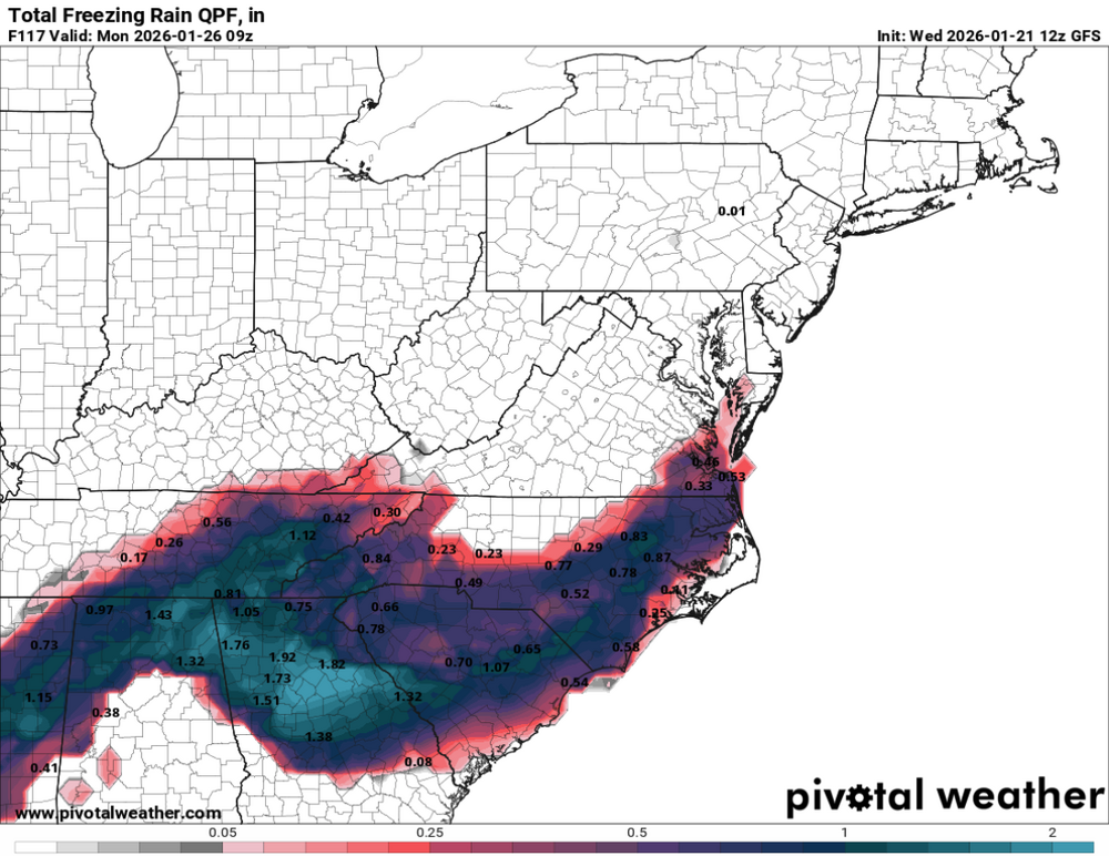
-
January 25/26 Jimbo Back Surgery Storm
Thrasher Fan replied to Jimbo!'s topic in Southeastern States
GFS holds serve again. What a battle we have going folks.