Thrasher Fan
-
Posts
1,399 -
Joined
-
Last visited
Content Type
Profiles
Blogs
Forums
American Weather
Media Demo
Store
Gallery
Everything posted by Thrasher Fan
-

January 25/26 Jimbo Back Surgery Storm
Thrasher Fan replied to Jimbo!'s topic in Southeastern States
0z GFS on the clock. -
January 25/26 Jimbo Back Surgery Storm
Thrasher Fan replied to Jimbo!'s topic in Southeastern States
NAM'd -
January 25/26 Jimbo Back Surgery Storm
Thrasher Fan replied to Jimbo!'s topic in Southeastern States
Is the NAM even worth considering anymore?? Not for just this storm but period. This is terrible. -
January 25/26 Jimbo Back Surgery Storm
Thrasher Fan replied to Jimbo!'s topic in Southeastern States
That HRRR run couldn't really be depicted from a single image map. It was the run in the early hours versus its previous one. -
January 25/26 Jimbo Back Surgery Storm
Thrasher Fan replied to Jimbo!'s topic in Southeastern States
Quite a jog south on HRRR. Hmmm -
January 25/26 Jimbo Back Surgery Storm
Thrasher Fan replied to Jimbo!'s topic in Southeastern States
HRRR.... -
Some clipper action in the midweek?
-
January 25/26 Jimbo Back Surgery Storm
Thrasher Fan replied to Jimbo!'s topic in Southeastern States
And thats only if the CAD is eroded which is insanely difficult to model. 2m temps are already riding that 31-33° range at that time for most of the metro. -
January 25/26 Jimbo Back Surgery Storm
Thrasher Fan replied to Jimbo!'s topic in Southeastern States
Negative.
-
January 25/26 Jimbo Back Surgery Storm
Thrasher Fan replied to Jimbo!'s topic in Southeastern States
GFS 2m temps colder (CAD stronger) 69h -
January 25/26 Jimbo Back Surgery Storm
Thrasher Fan replied to Jimbo!'s topic in Southeastern States
Afternoon discussion from KFFC. Its long so I'll just post the link. https://forecast.weather.gov/product.php?site=FFC&issuedby=FFC&product=AFD&format=CI&version=1&glossary=1 -
January 25/26 Jimbo Back Surgery Storm
Thrasher Fan replied to Jimbo!'s topic in Southeastern States
NAM not as strong with the CAD Getting into its drunken hours now. -
January 25/26 Jimbo Back Surgery Storm
Thrasher Fan replied to Jimbo!'s topic in Southeastern States
NotAModel is out to 27h. No changes of note -
January 25/26 Jimbo Back Surgery Storm
Thrasher Fan replied to Jimbo!'s topic in Southeastern States
One might say that it is going to be put on ice. I'll see myself out. -
January 25/26 Jimbo Back Surgery Storm
Thrasher Fan replied to Jimbo!'s topic in Southeastern States
Anyone know verification scores of the HRRR at its end point of runs? Been a minute since I studied that model's scores. Storm will be coming into our playing field on the 18z. -
January 25/26 Jimbo Back Surgery Storm
Thrasher Fan replied to Jimbo!'s topic in Southeastern States
KFCC has expanded the Winter Storm Watch to include south metro ATL counties. URGENT - WINTER WEATHER MESSAGE National Weather Service Peachtree City GA 1243 PM EST Thu Jan 22 2026 GAZ030>034-041>051-053>062-072>076-230800- /O.EXB.KFFC.WS.A.0001.260124T1800Z-260126T1500Z/ Polk-Paulding-Cobb-North Fulton-Gwinnett-Haralson-Carroll-Douglas- South Fulton-DeKalb-Rockdale-Walton-Newton-Morgan-Greene- Taliaferro-Coweta-Fayette-Clayton-Spalding-Henry-Butts-Jasper-Putnam- Hancock-Warren-Jones-Baldwin-Washington-Glascock-Jefferson- Including the cities of Carrollton, Jackson, Milledgeville, Sparta, Madison, Newnan, East Point, Eatonton, Monroe, Dallas, Stockbridge, Cedartown, Douglasville, Decatur, Greensboro, Warrenton, Griffin, Peachtree City, Monticello, GIbson, Marietta, Atlanta, Conyers, Louisville, Crawfordville, Riverdale, Lawrenceville, Covington, Gray, Sandersville, and Bremen 1243 PM EST Thu Jan 22 2026 ...WINTER STORM WATCH IN EFFECT FROM SATURDAY AFTERNOON THROUGH MONDAY MORNING... * WHAT...Significant icing possible. Total ice accumulations around four tenths of an inch possible. * WHERE...Portions of central, east central, north central, northwest, and west central Georgia. * WHEN...From Saturday afternoon through Monday morning. * IMPACTS...Power outages and tree damage are likely due to the ice. Travel could be nearly impossible. The hazardous conditions could impact the Monday morning commute. PRECAUTIONARY/PREPAREDNESS ACTIONS... Monitor the latest forecasts for updates on this situation. Persons should consider delaying all travel. If travel is absolutely necessary, drive with extreme caution. Consider taking a winter storm kit along with you, including such items as tire chains, booster cables, flashlight, shovel, blankets and extra clothing. Also take water, a first aid kit, and anything else that would help you survive in case you become stranded. -
January 25/26 Jimbo Back Surgery Storm
Thrasher Fan replied to Jimbo!'s topic in Southeastern States
I can remember case studies being planned back in the early 2000s about this when we had want felt like ice storm after ice storm in the SE. Wonder if those ever happened or if nothing could be added to the models to better identify it. -
January 25/26 Jimbo Back Surgery Storm
Thrasher Fan replied to Jimbo!'s topic in Southeastern States
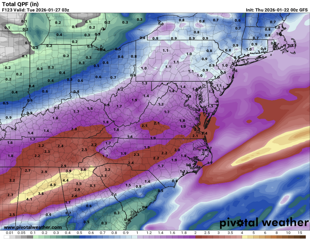
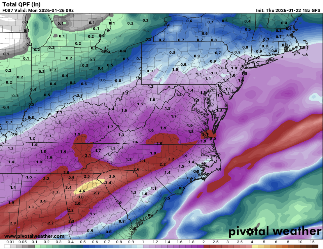
This has been consistent for several runs of the GFS now. QPF never been a problem on that model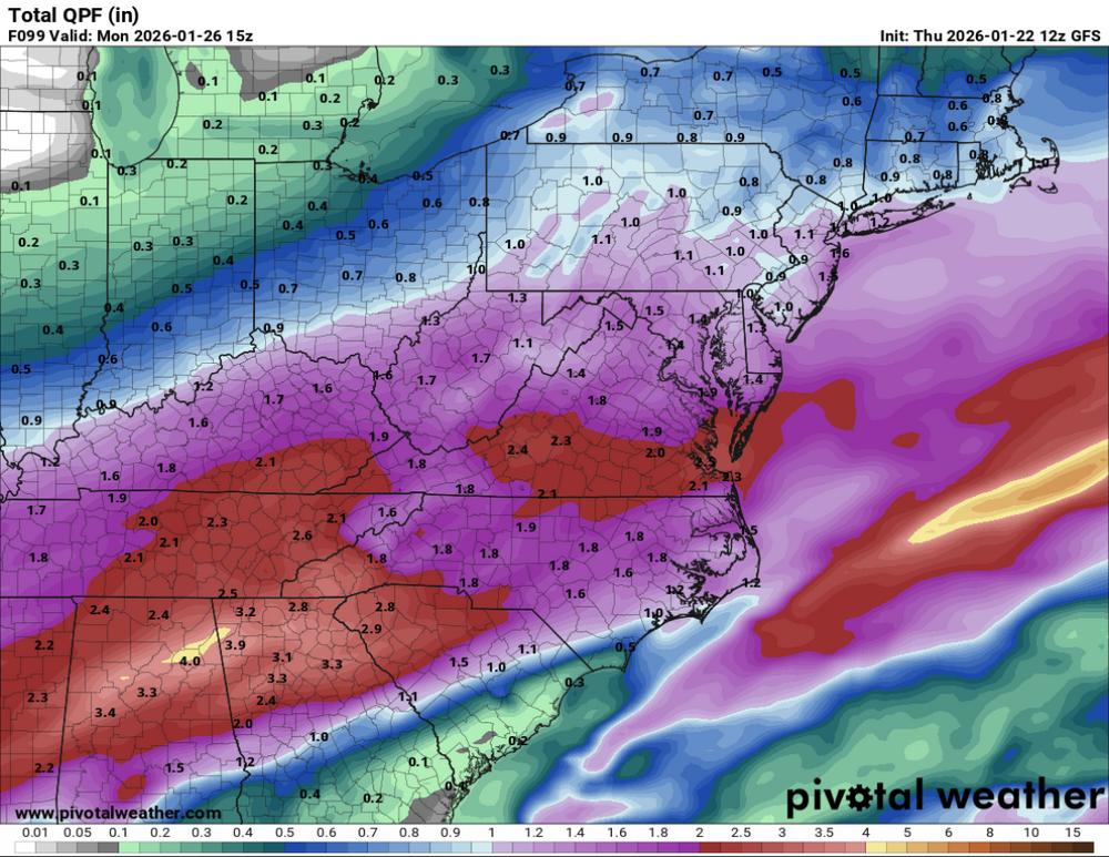
-
January 25/26 Jimbo Back Surgery Storm
Thrasher Fan replied to Jimbo!'s topic in Southeastern States
12z GFS similar to previous run out to 36h. Maybe a touch colder. Nothing to write home about -
I wouldn't trust the NAM beyond 12 hours. It didn't even sample the current precip over GA correctly at initiation.
-
January 25/26 Jimbo Back Surgery Storm
Thrasher Fan replied to Jimbo!'s topic in Southeastern States
Nice, dry weekend for most per the NAM. What a dumb model. That run makes almost zero sense. -
IT guy here. Haha Has there been any chatter of upgrading the boards to Invision Community 5? A lot of new features that I think the users would love to have and maybe get some of the guest users to create accounts.
-
GFS would like to play another 18 holes a week after this weekend's round.

-
January 25/26 Jimbo Back Surgery Storm
Thrasher Fan replied to Jimbo!'s topic in Southeastern States
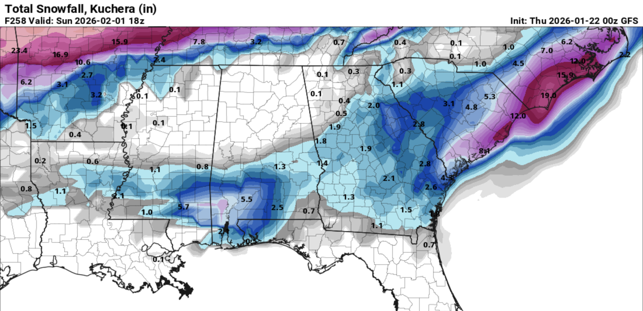
And that is more than enough time to decimate a pine tree forest that hasn't seen an ice storm in close to a decade. -
January 25/26 Jimbo Back Surgery Storm
Thrasher Fan replied to Jimbo!'s topic in Southeastern States
Flood watch on top of ice storm warning? Crazy QPF