paweather
-
Posts
11,624 -
Joined
-
Last visited
Content Type
Profiles
Blogs
Forums
American Weather
Media Demo
Store
Gallery
Everything posted by paweather
-

Central PA Winter 25/26 Discussion and Obs
paweather replied to MAG5035's topic in Upstate New York/Pennsylvania
holy moly! -
Central PA Winter 25/26 Discussion and Obs
paweather replied to MAG5035's topic in Upstate New York/Pennsylvania
Look like a 16-20” GFS storm. One for the history books -
Central PA Winter 25/26 Discussion and Obs
paweather replied to MAG5035's topic in Upstate New York/Pennsylvania
Talk about a hammer down the GFS goes crazy! -
Central PA Winter 25/26 Discussion and Obs
paweather replied to MAG5035's topic in Upstate New York/Pennsylvania
ICON puts the hammer down -
Central PA Winter 25/26 Discussion and Obs
paweather replied to MAG5035's topic in Upstate New York/Pennsylvania
Are you including south central PA to that? -
Central PA Winter 25/26 Discussion and Obs
paweather replied to MAG5035's topic in Upstate New York/Pennsylvania
Look at all the moisture to the west Wow! -
Central PA Winter 25/26 Discussion and Obs
paweather replied to MAG5035's topic in Upstate New York/Pennsylvania
Not way south we get hammered after 84 -
Central PA Winter 25/26 Discussion and Obs
paweather replied to MAG5035's topic in Upstate New York/Pennsylvania
Let it snow! -
Central PA Winter 25/26 Discussion and Obs
paweather replied to MAG5035's topic in Upstate New York/Pennsylvania
Gotcha! -
Central PA Winter 25/26 Discussion and Obs
paweather replied to MAG5035's topic in Upstate New York/Pennsylvania
A foot of snow? -
Central PA Winter 25/26 Discussion and Obs
paweather replied to MAG5035's topic in Upstate New York/Pennsylvania
The storm of the Century! -
Central PA Winter 25/26 Discussion and Obs
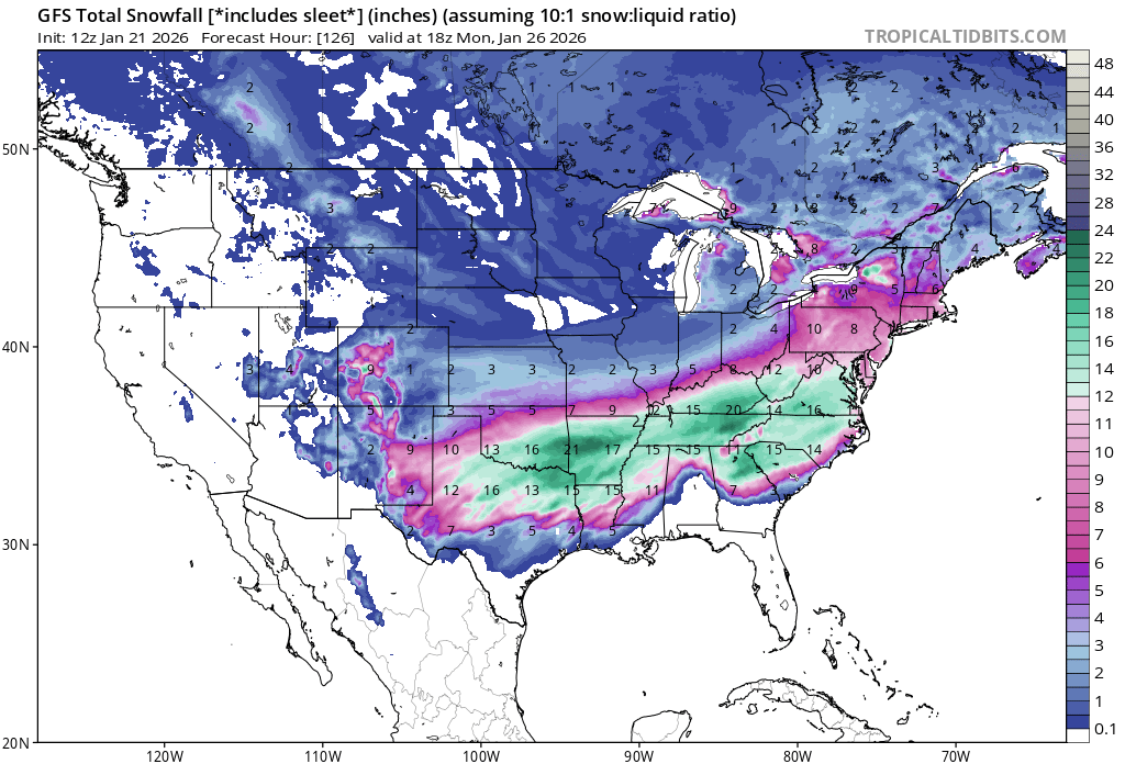
paweather replied to MAG5035's topic in Upstate New York/Pennsylvania
18z GFS -
Central PA Winter 25/26 Discussion and Obs
paweather replied to MAG5035's topic in Upstate New York/Pennsylvania
It is turning into a Miller B transferring the energy a little later in WV instead of TN on some models. Typical model waffling as they always do especially since models have been very consistent up to this point with the storm. Yesterday there was suppression concerns now it is “it’s going to far north to transfer to the coast for all snow” concerns. It happens either way this is the storm we will be talking about for quite some time IMO. -
Central PA Winter 25/26 Discussion and Obs
paweather replied to MAG5035's topic in Upstate New York/Pennsylvania
Relax still 4 days out and again we get a good thump If a changeover for a period of time occurs -
Central PA Winter 25/26 Discussion and Obs
paweather replied to MAG5035's topic in Upstate New York/Pennsylvania
We had the same in the 1993 super storm where sleet fell but it didn’t hurt amounts plus a good front end thump before any changeover would occur. -
Central PA Winter 25/26 Discussion and Obs
paweather replied to MAG5035's topic in Upstate New York/Pennsylvania
What’s wrong with it? -
Central PA Winter 25/26 Discussion and Obs
paweather replied to MAG5035's topic in Upstate New York/Pennsylvania
12z EURO -
Central PA Winter 25/26 Discussion and Obs
paweather replied to MAG5035's topic in Upstate New York/Pennsylvania
EURO is a beat down great run! -
Central PA Winter 25/26 Discussion and Obs
paweather replied to MAG5035's topic in Upstate New York/Pennsylvania
I posted them already at least a foot of Snow likely more -
Central PA Winter 25/26 Discussion and Obs
paweather replied to MAG5035's topic in Upstate New York/Pennsylvania
Not sure what you mean majority of models showing at least 8” or more before icing would occur -
Central PA Winter 25/26 Discussion and Obs
paweather replied to MAG5035's topic in Upstate New York/Pennsylvania
We still get a good front end thump -
Central PA Winter 25/26 Discussion and Obs
paweather replied to MAG5035's topic in Upstate New York/Pennsylvania
12z UKIE puts the hammer down -
Central PA Winter 25/26 Discussion and Obs
paweather replied to MAG5035's topic in Upstate New York/Pennsylvania
CMC drives the L into West Virginia increasing the amount of ice in PA but still a front end thump probably wrong -
Central PA Winter 25/26 Discussion and Obs
paweather replied to MAG5035's topic in Upstate New York/Pennsylvania

-
Central PA Winter 25/26 Discussion and Obs
paweather replied to MAG5035's topic in Upstate New York/Pennsylvania