paweather
-
Posts
11,625 -
Joined
-
Last visited
Content Type
Profiles
Blogs
Forums
American Weather
Media Demo
Store
Gallery
Everything posted by paweather
-

Central PA - Summer 2021
paweather replied to Itstrainingtime's topic in Upstate New York/Pennsylvania
Dark as can be nothing yet but soon. -
Central PA - Summer 2021
paweather replied to Itstrainingtime's topic in Upstate New York/Pennsylvania
The time is off. -
Central PA - Summer 2021
paweather replied to Itstrainingtime's topic in Upstate New York/Pennsylvania
Weather Alert Special Weather Statement issued July 12 at 3:17PM EDT by NWS State College...A STRONG THUNDERSTORM WILL AFFECT PARTS OF LANCASTER...LEBANON... AND DAUPHIN COUNTIES UNTIL 400 PM EDT... At 315 PM EDT, Doppler radar indicated a strong thunderstorm over Highspire, moving northeast at 15 mph. Torrential rain is expected. Rainfall rates of 1 to 2 inches are possible in just 30 minutes. Pea size hail and wind gusts up to 50 mph are possible. Locations impacted include... Hershey, Elizabethtown, Middletown, Palmyra, Steelton, Hummelstown, Campbelltown, Highspire, Royalton, Timber Hills, Mount Gretna Heights, Lawn, York Haven, Mount Gretna, Three Mile Island, Penn State Harrisburg, Harrisburg International Airport, Penn State College Of Medicine, Hershey Park and Elizabethtown College. -
Central PA - Summer 2021
paweather replied to Itstrainingtime's topic in Upstate New York/Pennsylvania
And it is hardly moving. -
Central PA - Summer 2021
paweather replied to Itstrainingtime's topic in Upstate New York/Pennsylvania
Welcome to Lebanon County - Rain Capital. -
Central PA - Summer 2021
paweather replied to Itstrainingtime's topic in Upstate New York/Pennsylvania
Harrisburg is about to get rocked. -
Central PA - Summer 2021
paweather replied to Itstrainingtime's topic in Upstate New York/Pennsylvania
Full sun here should change shortly. -
Central PA - Summer 2021
paweather replied to Itstrainingtime's topic in Upstate New York/Pennsylvania
Surely Winter Time Fun if we had this! -
Central PA - Summer 2021
paweather replied to Itstrainingtime's topic in Upstate New York/Pennsylvania
Isn't that the truth! -
Central PA - Summer 2021
paweather replied to Itstrainingtime's topic in Upstate New York/Pennsylvania
Good point. LOL -
Central PA - Summer 2021
paweather replied to Itstrainingtime's topic in Upstate New York/Pennsylvania
Yep. LOL! -
Central PA - Summer 2021
paweather replied to Itstrainingtime's topic in Upstate New York/Pennsylvania
How do you say this?? GFS is near perfect! -
Central PA - Summer 2021
paweather replied to Itstrainingtime's topic in Upstate New York/Pennsylvania
Storms are starting to brew out to our west! -
Central PA - Summer 2021
paweather replied to Itstrainingtime's topic in Upstate New York/Pennsylvania
Insane: -
Central PA - Summer 2021
paweather replied to Itstrainingtime's topic in Upstate New York/Pennsylvania
For sure. I hope you capitalize. -
Central PA - Summer 2021
paweather replied to Itstrainingtime's topic in Upstate New York/Pennsylvania
Yep crazy here as well. Sinkholes are Palmyra's favorites. -
Central PA - Summer 2021
paweather replied to Itstrainingtime's topic in Upstate New York/Pennsylvania
I say the same thing but our area is ripe for Storms all week. -
Central PA - Summer 2021
paweather replied to Itstrainingtime's topic in Upstate New York/Pennsylvania
True, very true! -
Central PA - Summer 2021
paweather replied to Itstrainingtime's topic in Upstate New York/Pennsylvania
-
Central PA - Summer 2021
paweather replied to Itstrainingtime's topic in Upstate New York/Pennsylvania
Did it rain last night....Holy Smokes! -
Central PA - Summer 2021
paweather replied to Itstrainingtime's topic in Upstate New York/Pennsylvania
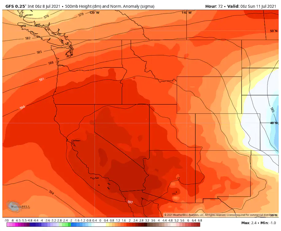
If you are going out West for the weekend:
-
Central PA - Summer 2021
paweather replied to Itstrainingtime's topic in Upstate New York/Pennsylvania
Got the line coming pass Altoona but no real cell growth as of yet. -
Central PA - Summer 2021
paweather replied to Itstrainingtime's topic in Upstate New York/Pennsylvania
No Doubt. -
Central PA - Summer 2021
paweather replied to Itstrainingtime's topic in Upstate New York/Pennsylvania
JI. -
Central PA - Summer 2021
paweather replied to Itstrainingtime's topic in Upstate New York/Pennsylvania
Clouds finally starting to increase.