
Trent
-
Posts
2,813 -
Joined
-
Last visited
Content Type
Profiles
Blogs
Forums
American Weather
Media Demo
Store
Gallery
Posts posted by Trent
-
-
Models have certainly trended better for tomorrow afternoon's potential snow. Could be a sneaky 2-4" band somewhere. Considering it hasn't snowed more than an inch at CLE in almost 10.5 months, I'll believe it when I see it.
-
After today's model runs it appears the low might run right over CLE this weekend. Even if it were take a more easterly track there just wouldn't be enough cold air around. Looks like a brief window for wrap around lake enhanced snow before winds shift to the wsw.
NAM hints at a few inches of enhanced/lake snow later on Sunday. I just wish we could keep a WNW flow for a couple days longer.
-

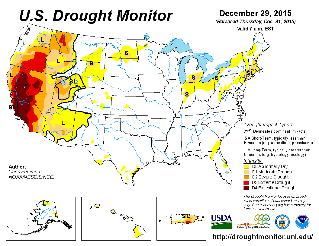
Here's something we haven't seen in quite a few years ... moderate winter drought conditions for a good chunk of Northern Ohio.
-
I honestly doubt anyone hit 4", pretty incredible bust.
I agree that from a major synoptic storm perspective, I can't recall one good synoptic storm since the 10-11 winter that lived up to expectations in Cleveland. However, there have been many minor to moderate events in the 13-14 and 14-15 winters that over performed along with some busts.
We've had some "good" busts the past few winters and of course quite a few "bad" busts. What's odd, almost comical, is how nearly every storm ends up "busting" or not performing as modeled/forecasted. The past few years there've been maybe a handful of events that actually ended up performing to expectations. It's been a pretty bad string of storms (or lack thereof).
It's pretty remarkable how CLE (or anyone on the west side for that matter) hasn't had an inch of snow this winter. CLE is running a 19.5" snowfall deficit for the season as of today and that will only grow bigger through the week. You know it's a bad winter when the lakes are torching in early January, we finally get a northerly wind, and we still can't muster more than a dusting across the majority of Cuyahoga County.
-
PNS from CLE showing some lackluster totals. I don't even think advisory totals were met in Geauga County, with about an inch in Chardon and Burton. It just seems like an endless string of busts the past few years.
-
I don't understand the current advisories up for the region. Advisories and warnings were dropped for the east, but remain in place for Cuyahoga which has seen 0-2" of snow the past 24 hours.
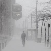
It's still amazing to me that Cleveland is pushing 10.5 months without a plowable snowfall. I'm sure there were quite a few who plow driveways on the side that thought for sure they'd get their first jobs of the season last night. But here we are at day 309 without any real snow.
-
Things really falling apart on radar. I only ended up with a trace of snow thus far, and that will probably do it.
At this point it looks like it would be quite a stretch for CLE to get an inch today.
This event seems to be par for the course considering this winter so far.
-
We'll see if the radar fires up shortly. I was kind of surprised to see nothing much had fallen across Cuyahoga overnight, even across the higher elevations around 271. I'm surprised we've been under an advisory for so long, those probably shouldn't have started yesterday.
Band looks pretty healthy in Geauga at the moment.
-
NWS BUF is testing an experimental lake effect snow warning polygon system off Lake Ontario. I hope this proves to be successful.
With severe storms now polygons, there's no reason that winter weather products can't be similar. It would be nice if western Cuyahoga could stay out of lake effect warnings that affect the 271 corridor.
Nice write up as usual OHweather. This might finally be CLE's first inch in over 10 months. These set ups generally aren't favorable for us along the lakeshore, so I might be waiting quite a bit more.
-
I loved last years tundra winter of deep snow, but outside of the massive Feb 1st snowstorm there werent really any big storms. Now 2013-14 on the other hand, that winter was a haven for one snowstorm after another, We had 6 storms over 6"+ here (4 of the 6 were over 8") so its crazy if Cleveland missed all of them.
They pretty much did. Winter 13/14 was snowy, but just nickel and dimes here. Largest storm that winter was 5.5" on December 14, 2013. There hasn't really been anything noteworthy the past few years. Sure, it's been cold, but big storms have been non existent.
-
I think there's a half decent chance CLE gets their first inch on Monday the 4th. Needless to say we're a tad behind...
It's now up to 306 days since CLE last had an inch of snow fall. Just a brutal snowless stretch thus far.
CLE is certainly well over due for a big synoptic storm. We've been shut out the past few years considering the pattern the Midwest and East Coast were in. Perhaps we can get a thread the needle type storm this winter.
-
Impressive run at above freezing temps at CLE. The last time it was below freezing was Sunday the 20th.
This month will also shatter the record for warmest December by a good 2 degrees. So far temps for November and December are slightly above that of 1931. That ended up being Cleveland's second least snowy winter on record with a meager 21.5" falling.
-
Plugging in forecasted highs and lows for the rest of the month gives a predicted average monthly temperature of 44.0 degrees. The previous record warm December was in 1889 at 42 degrees. Obviously a lot can change over the week with unexpected midnight highs and lows, but it's almost certain this will be a historically warm 2 month period.
At this point I don't think it's realistic to expect anywhere near normal snowfall this winter. Hopefully we can at least salvage a good storm out of the winter and maybe a 2 week winter blast with lake effect. I'll say CLE finishes winter with about 34".
-
Had a couple tenths of an inch here in Lakewood when that band slipped through this morning. Any remnant of snow was melted here by noon, but for a brief few minutes it felt like winter.
-
What an incredible surge of warm air last night! Was that even forecast? It was 58 at about 8pm last night. IMBY I hit 60 around midnight.
Interestingly BKL hit 61 at midnight. The record high at CLE today was 61. While not officially a record based on where current records are kept, it's kind of bizarre to have near record warm occur in the middle of the night like that.
-
It's hard to believe it's mid December and there hasn't even been a threat of a snowstorm to follow here.
The airport will easily break the longest streak between 1 inch snowfalls on Thursday. It's hard to believe CLE can go that long without a "snow storm", the last being during the early morning hours on March 1.
-
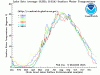
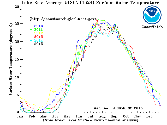
Here's the latest Lake Erie temperature graphic. Notice the relatively warm 2010 line and the drop off in early December. That corresponds to the massive lake effect event above.
With the ridiculous warm up for the weekend the 2015 line should stay very warm. If we can get the right arctic blast as in 2010 we could make up for lost time in the snow department very quickly. Unfortunately that's a pretty big IF. It's pretty sad when the 384 hour GFS doesn't even show any snow on a run in December.
-
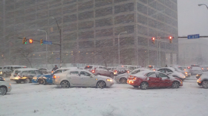
Looks like today is the anniversary of the surprise rush hour lake effect gridlock squall downtown. That early December was probably the best stretch of lake effect I've seen since I've lived up here. Several feet of snow piled up that week.
That might have been my favorite snow storm of all time. It's hard to believe in this day and age that much snow can fall without more than flurries being in the forecast.
When people went to work downtown that morning there was no snow in the forecast. People went about their day as normal. Just before lunch the band developed and stayed put through early evening. By about 3pm, 6" had fallen in a few hours and everyone decided to leave work at the same time to get home. It was absolute insanity because at that point the snow was really coming down at about 2" per hour between 3:30-5:30pm. People started running out of gas and that exacerbated the gridlock. And then no plows could get through so you had cars getting stuck which furthered the gridlock. By 7pm it was about over, but by then downtown had about 10-12" of snow and the damage was done. It certainly made me realize how useful advance warnings for snow are. Had this same event happened but with 2 days lead time, there probably wouldn't have been these types of issues as many people would have worked from home or planned accordingly.
If you had asked anyone at 10am that morning and told them that nearly a foot of snow would fall by the time they left work and it would take them up to 3 hours just to leave downtown, they would have laughed at you.
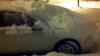
Here is a picture I took of the gridlock on East 9th and Lakeside Avenue:

This was my car:
-
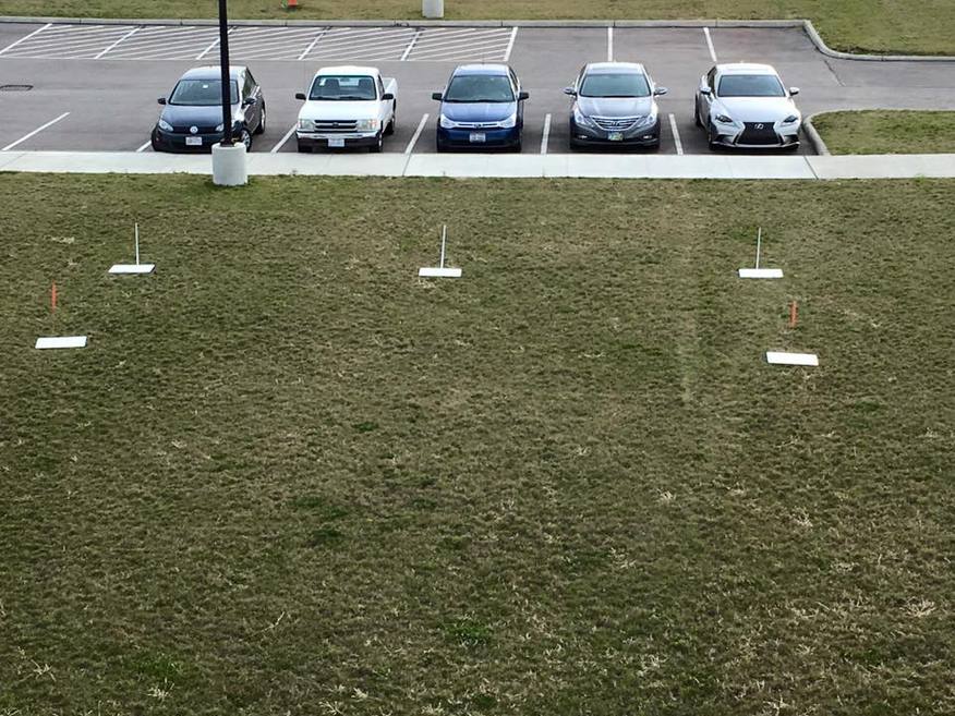
This is CLE's new location for measuring snow this winter. Here's some more info from the person who took the picture:
"Well here is where the weather observers will be taking snowfall measurements. Photo was taken indoors and there is a large wall just left of the picture. This is facing south."
He said last year they measured near the west end of an "open field". So we'll see if this makes a difference. Definitely have to think snow blowing off the building with a northerly wind would be a concern.
This weekend looks very warm. Record highs and warm lows will be threatened. Sunday's record warm low of 47 could be obliterated...the 0z Euro has a low of 58 for Sunday...wow.
So the new spot must be near the new air traffic control tower that opened this year. Hopefully the measurements improve. There's no doubt that a good 10" or so likely weren't measured the past few years.
The airport is now at the second longest stretch between 1 inch snowfalls. It's been 283 days since an inch of snow fell. For anyone who is in snow removal and is paid by the job, must be tough with those plows accumulating more dust on them than snow outside.
It will be interesting to see how warm the lows end up being. Unfortunately there are only 24 hour low stats. A warm overnight low is often erased by a 11:59pm low later that day. With 7 hours of darkness after sunset before midnight, every day has two chances to establish a low temperature this time of year.
-
Lake Erie really torching compared to the past 5 years and the pattern the next week shouldn't allow for much of a drop off in temperatures compared to past years.
If CLE can make it to December 17th without an inch falling, it would be the longest stretch between 1 inch snowfalls at the airport. The last inch at the airport was on March 1st. If CLE makes it to next Tuesday, it will be the second longest stretch between 1 inch snows, so that is a lock.

-
Had maybe a tenth or two of slop overnight. It stuck only to elevated surfaces. Temps look to be in the upper 30s along coastal Lake County so it was probably just rain there looking at the precipitation estimates. I'll be curious if any inland locations were able to pick up over an inch.
-
As always, great write up. It will be interesting how this plays out.
Also of note. It's interesting how the CLE snowfall totals were adjusted yesterday. The snowfall on November 21st was upped from .3" to .5" and the snow on November 22nd was upped from .2" to .3". Interestingly enough in early November the trace of snow that fell on October 17th was upped to .1".
I really wonder if snowfall is actually measured at CLE? Why would these adjustments come weeks after the snow fell? The snowfall totals at CLE were awful the past 3 or 4 years, perhaps they are doing a QA on measurements now. I guess we'll now have to wait a couple weeks after a snow storm to see what the "official" CLE total ends up being.
-
November was ugly(by winter standards) and December looks just as ugly. Plugging in the forecast temps over the weekend would make this the 4th warmest November on record at CLE.
Lake Erie is still torching, so if we can get the right set up when/if an arctic blast arrives, the snow belts could cash in. Last winter we had some great set ups, but mostly frozen lakes. Funny how that always works.
I wouldn't feel so bad about a much below average snowfall season if there was a nice widespread 12" storm thrown in. It's been quite a few years since Northeast Ohio was a jackpot in a synoptic storm.
-
With less than a week left for November, it's looking like this month should be able to make the top 10 warmest November's list.
Plugging in all the forecasted highs and lows for the last remaining days yields an average of 47.7 for CLE. Tenth warmest is 47.0, so there's quite a buffer if ends up trending colder the next few days.


Northern Ohio Obs/Discussion Part 2
in Lakes/Ohio Valley
Posted
I picked up a little over an inch of wind blown slop. CLE probably had between 1-1.5" so we'll see if our 1 inch streak finally comes to an end.