
Trent
-
Posts
2,813 -
Joined
-
Last visited
Content Type
Profiles
Blogs
Forums
American Weather
Media Demo
Store
Gallery
Posts posted by Trent
-
-
A few of the high res models this afternoon show best QPF from mid Lake County and points north through Friday morning. Winds should be a little more NW late morning Friday so hopefully those bands slide a bit more south.
-
57 minutes ago, OHweather said:
I'm a little bit irritated that CLE isn't even including Cuyahoga County in the hazardous weather outlook for the LES. They had a ridiculous mental block on issuing any lake effect products for Cuyahoga County last winter when the flow was WNW, and it looks like they're going to continue that this winter.
The lack of spotters in the eastern suburbs doesn't help, which is surprising considering there's easily a half million people in the eastern Cuyahoga County higher elevations. Splitting Cuyahoga into 2 or 3 zones would help and so would using polygon winter products.
As always, appreciate your insight and forecasts on the weather here!
-
Inland areas should do well, I'm sure watches will go out tonight.
From personal experience, windy events aren't good for lower elevation areas, so I'm not expecting much. CLE highlights this in their AFD, saying they don't expect a mega band to develop with the wind sheer. The wind direction looks almost ideal at this point though, but that's saying a lot when the event is 2.5 days away.
The Friday morning commute is going to be awful for 480 and 271.
-
It's nice to finally stop talking about all the records for how warm it's been and start talking snow. Interestingly, the CLE radar is going to be down this week for upgrades. That should make tracking the potential lake effect event this week extra painful as the neighboring radars won't be picking up these bands.
-
2 hours ago, dta1984 said:
That's incredible ! How far does the warmth stretch ? Is it region wide?
Most of the Midwest had a top 5 warmest fall, with many stations coming in at warmest or second warmest.
December needs to average 30.4 degrees or warmer for 2016 to be Cleveland's warmest year on record.
-
Month after month the warmth continues. November ended up finishing 2nd warmest on record for Cleveland.
June - 11th warmest
July - 4th warmest
August - warmest on record
September - 2nd warmest
October - 8th warmest
November - 2nd warmest
-
Looks like November will probably end as another top 5 warmest month on record. This pattern has to break soon?
December can still be 2 degrees below normal and this would still wind up being Cleveland's warmest year on record.
-
It was nice to see snow again. I picked up 0.3", enough to whiten the ground. I see CLE picked up 0.6" last night. CLE should finally record their first freeze tonight.
-
3 hours ago, NEOH said:
The low at CLE was 57 last night... it was 46 IMBY. Hopefully we see good model trends today. Be nice for the moisture to hang around a little longer.
IMBY, the coldest I've been this season is 35. There's definitely a lake influence this time of year with overnight lows.
I've noticed that I almost always see my first snow of the season before my first freeze. It's an odd quirk living near the lake.
-
7 minutes ago, dta1984 said:
Good analysis!
Cle seems to be biting in their latest discussion. Mentions potential of significant accumulations sat night -mon.
Yeah. That was pretty strong wording for this far out. There's even specific mention that it will turn to snow for lakeshore areas.
For what it's worth the airport still has not had a freeze, which is the latest ever for the airport location. There were 6 other earlier years, at the lakeshore, before the airport was built that still hadn't had a freeze yet. Lots of warm anomalies in that lake for the coming winter!
-
Hard not to notice how warm the past year has been. At CLE the past year is 0.8 degrees warmer than the previous warmest year in 2012.
I'm hoping we can finally break the constant above normal temperature days that have been firmly in place since the 4th of July.
CLE has still not had a first freeze yet, the last time it was this late in the season was 1946. If we can manage an early December arctic outbreak the LES belts could cash in nicely.
-
Got to love that early-November-balmy-upper-70s-World-Series weather in Cleveland today!
-
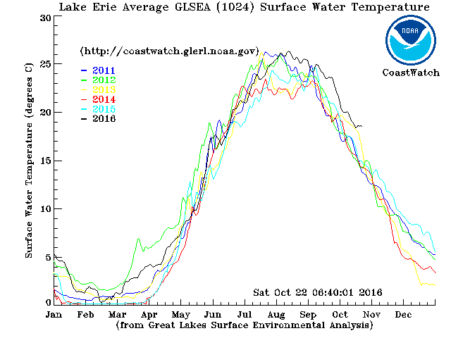
Here's the current Lake Erie temperature plot compared to the past 5 years. Temps should start to plunge this week, but we're still running way ahead of previous years.
-
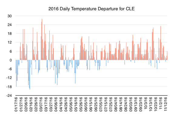
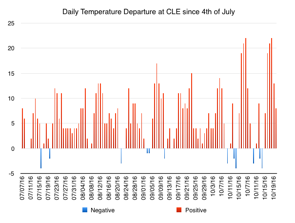
Our 3.5+ month stretch of consistently above normal temperatures is about to come to an end. What a run. Here are the daily temperature departures at CLE for the year and since 4th of July.
-
3 minutes ago, NEOH said:
Thanks. Amazing stretch of warmth. Yeah... the switch has to flip at some point. Let's just keep lake erie nice and warm until then. Lake temps are still in the mid 60's...
looks like that is right around average for the date which is surprising.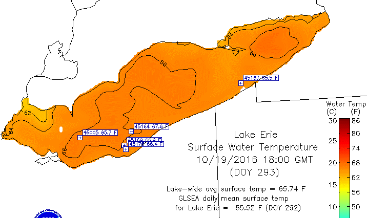
The 1980-2010 average water temp for the Cleveland CRIB station is 60 degrees for October 19. They are reporting a 65 degree water temperature today.
We're coming up on 3 years since that late October lake effect snow storm in NE Ohio. I could only imagine the tree damage that would cause if it happened this year ... Not to mention the possible implications of a potential World Series game being snowed out.
-
25 minutes ago, NEOH said:
Trent - Are we on track for record warm year? Those stats are pretty amazing.
We're about neck and neck with 2012 right now. November and December would need to average about 2.8 degrees above normal to clinch warmest year on record.
I'm betting that won't happen. I think we'll see the flip to winter around Thanksgiving. December could be interesting with Lake Erie and its record warm temps. It would be nice to finally get a winter with sustained cold and snow before Christmas.
-
Finally! Lows back in the 30s last night, albeit short lived and lakeshore areas were low 40s.
The southeast regional climate center has a feature to look up weather streaks. Thought there were a couple interesting ones this year for Cleveland.
The 35 consecutive days above 80 this summer was the 3rd longest stretch.
The 111 consecutive days above 70 this year was the longest stretch in Cleveland.
Currently it's been 152 consecutive days above 60 which is the second longest streak. The record is 154 days and the forecast calls for highs above 60 all next week so this will be broken.
I'll be glad to finally flip the switch to cold in Mid November. If this winter decides to "even itself out" from the prior 6 months, it's going to have to be a harsh one.
-
CLE recorded its first temperature in the 40s yesterday since May 23rd. Yesterday was also the first day in the past 30 to have a negative temp departure. Today doesn't look to have a negative departure so we will continue to wait to be able to string more than 2 days with a negative temp at CLE, which last happened 100 days ago!
-
51 minutes ago, OHweather said:
It's hard to believe we're getting into October now. It still feels like late summer; no really chilly days or nights yet, and there's almost no color either.
CLE hasn't dipped below 50 degrees since May 23rd. It's getting around that time for places to start having their first frosts of year and we haven't even been able to hit upper 40s yet.
Given the warmth this summer/fall and last winter's no show, it's felt like living somewhere in Virginia or North Carolina.
-
23 hours ago, OHweather said:
Looks like the 2nd warmest September on record at CLE, after the hottest August on record and hottest June-August period on record.
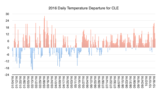
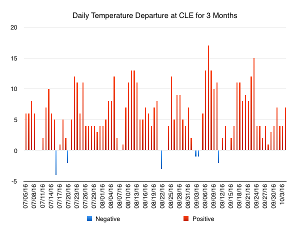
June was also the 11th hottest on record and July was 5th hottest on record. It really has been a remarkable stretch of warm/hot weather. Here is the daily departure at CLE over the past 3 months. I wouldn't have thought a chart like this was possible. To run a 3 month average departure of +5.6 for this time of year is just incredible. I'm surprised this hasn't been more newsworthy. Eventually this pattern has to break and at that time it'll be cold enough for snow, so perhaps we'll have a snowy start to winter. Imagine this chart reversed for Dec-Feb!

-
The heat continues. Even the "cooler temps" this week have still been above average. This graph below tells it all. This is the daily temperature departure from CLE everyday this year.
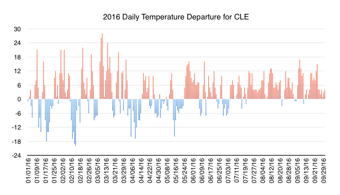
Except for a few isolated days, the past 3 months have had above average temperatures nearly every day. Only 25% of days this year have been between -3 and +3 degrees above average. Our weather is certainly just one extreme or the other, 28% of days this year were higher than +10 or colder than -10.
-
The Lake Erie temperature anomalies are just insane right now. I can only imagine what will happen if this keeps up.
Since the 4th of July CLE has only had 6 days with a negative temp departure. It's just been an unreal stretch of persistent warmth.
-
It was a record hot summer for Cleveland and Akron. Just persistent warmth all summer long. In fact, in the last 65 days, only 5 have had average temperatures below average and those days were just barely below average. You have to go back over 2 months to find a day that was more than 4 degrees below average. As always around this time of year, we start to watch the lake temps. Lake Erie is boiling, so hopefully we can cash in come winter. Hopefully no more SW wind events to start this winter.
000
SXUS71 KCLE 070049
RERCLE

RECORD EVENT REPORT
NATIONAL WEATHER SERVICE CLEVELAND OH
848 PM EDT TUE SEP 6 2016

RECORD WARMTH AT CLEVELAND AND AKRON CANTON FOR SUMMER 2016. MANSFIELD HAD THE
2ND WARMEST SUMMER ON RECORD.

CLEVELAND 2016 SUMMER SEASON MEAN AVERAGE TEMPERATURE OF 75.5 REPLACED THE
RECORD OF 75.1 SET DURING THE SUMMER OF 1949.

AKRON CANTON 2016 SUMMER SEASON MEAN AVERAGE TEMPERATURE OF 74.2 BEAT OUT
THE PREVIOUS RECORDS OF 73.8 SET DURING THE SUMMERS OF 1991 AND 1931.

MANSFIELD 2016 SUMMER SEASON MEAN AVERAGE TEMPERATURE OF 73.7 TIED WITH 2ND
WARMEST SUMMER SET IN 1995. WHILE RECORD WARMEST SUMMER REMAINS AT 74 SET IN
1934.


$$

THOMPSON
-
Missed the rain again overnight. I don't think I've had more than 2" of rain since mid May. Normal is closer to 7".
2016 is turning out to be a rather mundane year weather wise across northeast Ohio.
Northern Ohio Obs/Discussion Part 2
in Lakes/Ohio Valley
Posted
The latest run actually has a 6-10" band through tomorrow morning from about Avon Lake through Downtown Cleveland and then east into Geauga County. There appears to be a small bullseye of about 12" near Westlake. I'm guessing that scenario is out to lunch.