

dta1984
-
Posts
1,734 -
Joined
-
Last visited
Content Type
Profiles
Blogs
Forums
American Weather
Media Demo
Store
Gallery
Posts posted by dta1984
-
-
Glad to see the euro remaining steady.
-
 1
1
-
-
41 minutes ago, OHweather said:
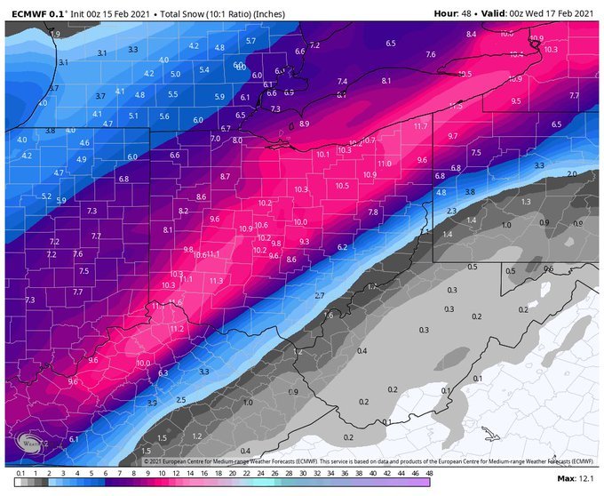
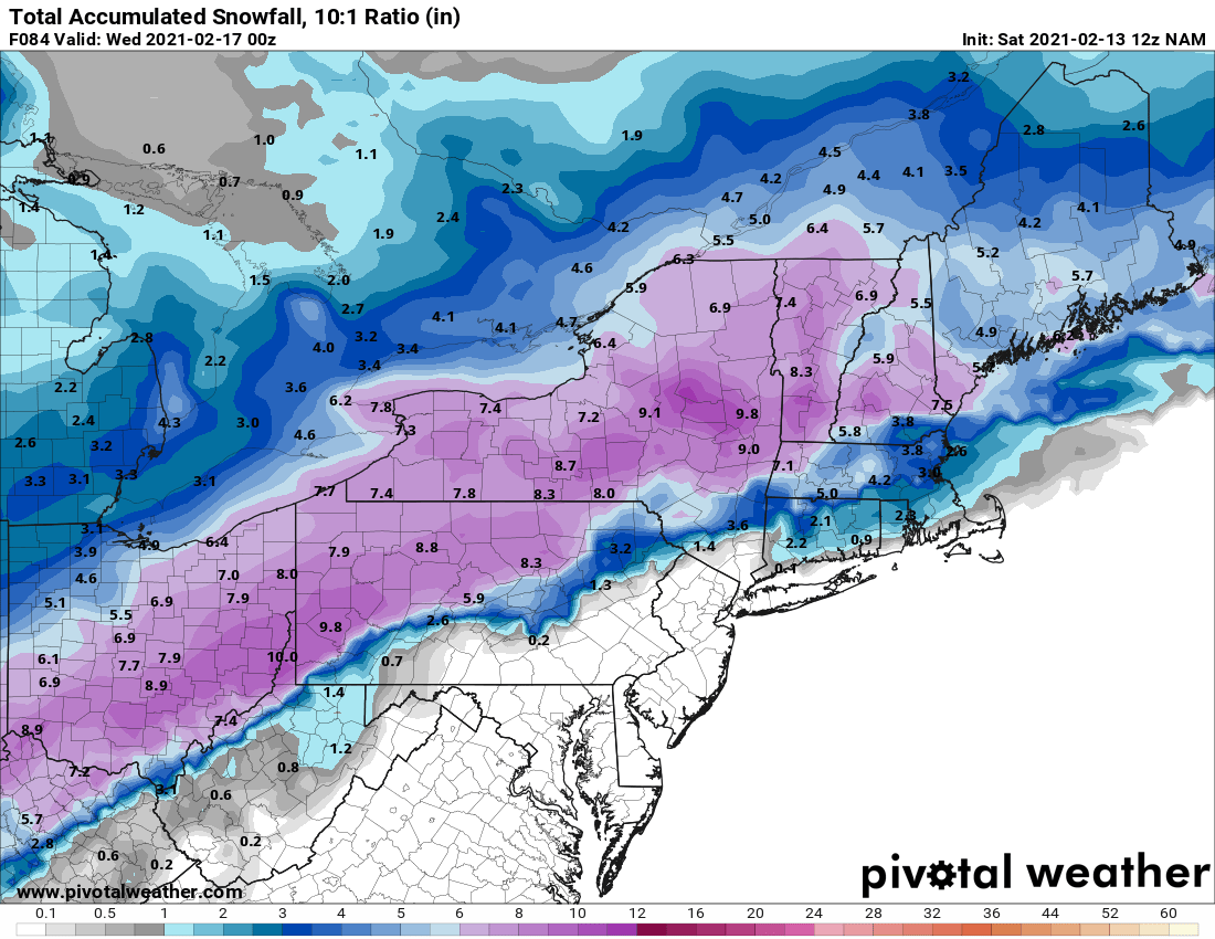
I think 8-12" is good for the Cleveland area, may be a tad more if some lake-enhancement occurs in Cuyahoga County or points west with a NNE flow. With an 850mb low track near or just east of I-71 I do think the heaviest axis ends up solidly west of that corridor, and could see Akron getting a bit less than Cleveland and Youngstown getting several inches less and trying to sleet or dry slot. This will be another solid storm for the Cleveland area in a winter that's seen a few already.
Always appreciated forecast! I'll be pulling for a slightly E track, but can't complain to 8-12" .
-
Euro looks to be holding and not bumping too far nw.
-
Looking good for the I 71 areas in Ohio
-
Pretty good looking mean @ 10:1 for the I 71 area in Ohio

-
Just now, WHEATCENT said:
These models are an absolute joke
Ya seems like an over correction. Let's see how the rest of the runs go today.
12z hrr seems to show lake shore areas getting some enhancement.
.thumb.png.f906ac33df4a207aac0a9c1f5446e721.png)
-
21 minutes ago, buckeye said:
I decided to go into lurking-only mode back in early spring. Just needed to separate myself from here for awhile. Didn't like who I became being sucked into a thread and a topic that in my opinion has no place here. This is where we come to share our illogical and unique passion for weather. It's the only place we can do it. That's ALL this place should ever be. That's my opinion and the last I will say about it
")
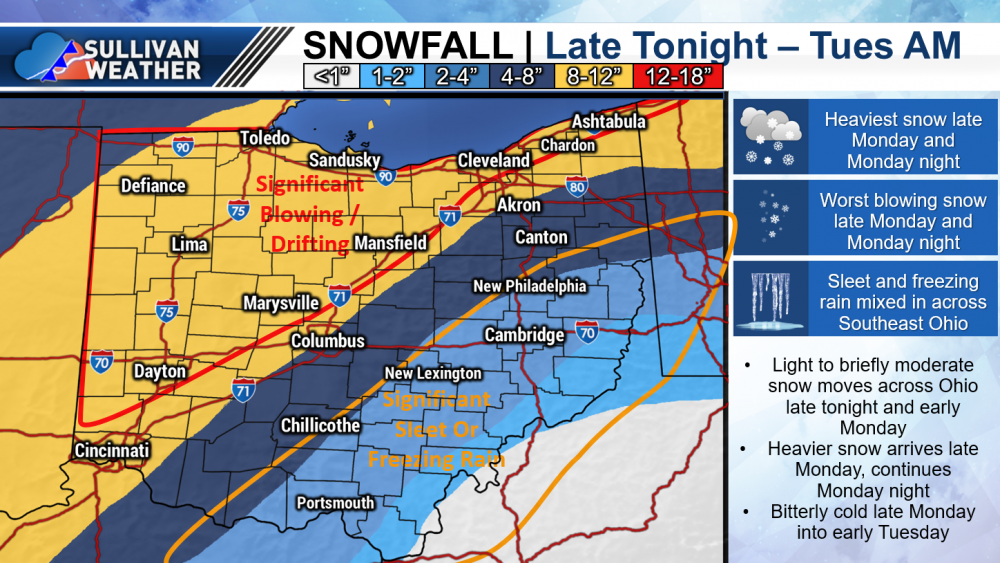
So on a lighter note, I did plan to start posting around Xmas but then we actually got a snowstorm on Xmas eve/day and then more snow, and now we sit with a snow cover and a potential decent storm coming in on top. I told pondo and dilly that since I stopped posting we were having the best winter in years and I was afraid I might jinx it. So let me apologize in advance to my Ohio brethren if this turns into a 1-3" turd now that I'm back.
 As far as the later week threat, that's always been tenuous, so I ain't taking the blame if that washes us out.
Welcome back Buckeye, I totally agree with your first paragraph

Glad to see a spread the wealth storm for all of Ohio. Classic 2004 or 2008 style would be nice.
-
1
-
-
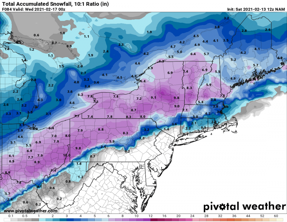
So far, morning runs have mostly been good to Ohio. The Nam is getting a little uncomfortable with sliding southeast. At 10:1, still looking like a 6"+ event.
-
2 hours ago, Nickysixes said:
They're very good at following orders. Our new Chinese-centric government will appreciate that
Lol but the Chinese govt doesn't lie! Here's a gem about the Wuhan virus.
Almost as good as the pics of all those people (actors) in Wuhan collapsing in the streets last Jan.

-
21 minutes ago, NEOH said:
Looking like a 1- 4" type snowfall this weekend depending on the model. Getting concerned the potential larger storm early next week could be a miss to the SE.
That's better than nothing I suppose... We've had alot of smaller snowfalls lately, itching for a bigger storm. Maybe next week....
-
-
2 hours ago, StormfanaticInd said:
What???
Why would a healthy (under 65), not at risk person take it?
-
 1
1
-
-
On 2/9/2021 at 2:20 AM, StormfanaticInd said:
There are side effects with every medication. The news media knows this but sensationalizes it for ratings. Smh
It is important the side effects are known so people can make a rational decision if they want to take this experimental vaccine. No reason for any healthy person under 65 to take it.
-
 1
1
-
-
6 minutes ago, NEOH said:
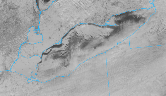
Now that's a lot of ice. Hard to believe the majority of our snow has come from synoptic events this year given how long the lake was open.
Yikes that was fast.
Persistent on and off snow the past few days..... amounting to 3.5" since Sunday. Hopefully a bigger storm to track this weekend.
-
24 minutes ago, NEOH said:
Just dumping LES -- cotton ball size flakes. Nice band hugging the shoreline and should remain there for most of the day. Too bad there is a lot of ice on the western basin as this is a perfect wind direction.
Nice surprise this morning. Cle mentioned 290 flow, which is perfect. Could see 2-4" being possible, looks like at least an inch down.
-
Noticed the scroll display screen in downtown Chardon has a screen for snowfall to date. Just about 5" more than what I've measured so far.

-
32 minutes ago, NEOH said:
We should get a quick thump prior to temps going above freezing... the front comes through quickly so there won't be a lot of time for melting. You may do really well up by the lakeshore with lake effect given the expected wind direction. We'll be frigid with mostly sunny skies here to your south.
Hopefully there's a good burst of snow over the weekend. A few models show widespread 4-6". Certainly will have good ratios.
.thumb.png.a940f041c7bdb55652b253dcb8742d35.png)
-
8 minutes ago, WHEATCENT said:
more rain and melting and highs at 35-39 just in time for bare ground and extreme artic air.

Not sure what you've got, but the bottom few inches out here is pretty solid. I doubt it all melts... especially if the high temps come over night.
-
Didn't get a chance to measure this morning, but looks to be around 2" new. More than I expected looking at the radar, but ratios helped.
-
Picked up another 1", 1-2 in the fc for the rest of the day.
Looks like some arctic air makes an appearance next week. That'll surely freeze the lake quickly.
-
I've got 1" so far this morning, snowing lightly, but looks to be a break soon.
The Cle forecast and some short range models have an odd finger of higher accums in eastern Geauga. Interested to see how this plays out.
-
15 minutes ago, WHEATCENT said:
The nam and GFS are the only ones keeping us on the lake with 4-7 any idea why the UK/EURO/CANADIAN keep it south?
Possibly dry air from north winds off the lake? Not sure, but it is weird the low totals some models show around Cleveland as NEOH mentioned above.
The NAM is higher resolution, so I'm curious how it and some of the other short range models handle that area as we get closer. Seems most runs today were a tick up in amounts, hopefully that continues.
-
2 minutes ago, WHEATCENT said:
nice run from the NAM this morning

Beat me to it! Haha. Here's the higher res 3k ...still snowing at the end.
.thumb.png.cb13de817c04f6e208585e895be92934.png)
-
1 hour ago, NEOH said:
Model trends were not good last night for the northeast corner of the state. Really shows the impact of the dry air coming in on a ENE wind direction. We'll be watching precip evaporate at is pushes in from the SW. However, we will be just north of the 700 and 850mb low tracks which is good spot to be. Will probably see a similar set-up to the previous storm where the snow on the north side is farther north than depicted on the models. Thinking 3 - 6" is a good call for much of the area... higher amounts the further southwest you are.
Seems like a good call. 12z Nam was a slight increase from previous runs for us too. General 4-6" across the area. This was the first run with sampling I believe.

-
1
-


.png.5a0931b9e59f59a5477b16777dfd803a.png)

.png.048724708787d18f5f9767dc2b07d2bb.png)

.png.84e2af113e066e3ccbc805afb9b70e86.png)
Northern Ohio Obs/Discussion Part 2
in Lakes/Ohio Valley
Posted
Ya was just thinking the same thing. Riding that line can pay off. Looks like Nam is better for us, but mixing is close.