

SluggerWx
-
Posts
892 -
Joined
-
Last visited
Content Type
Profiles
Blogs
Forums
American Weather
Media Demo
Store
Gallery
Everything posted by SluggerWx
-
Devastating tornado strikes Joplin, Missouri
SluggerWx replied to Hoosier's topic in Weather Forecasting and Discussion
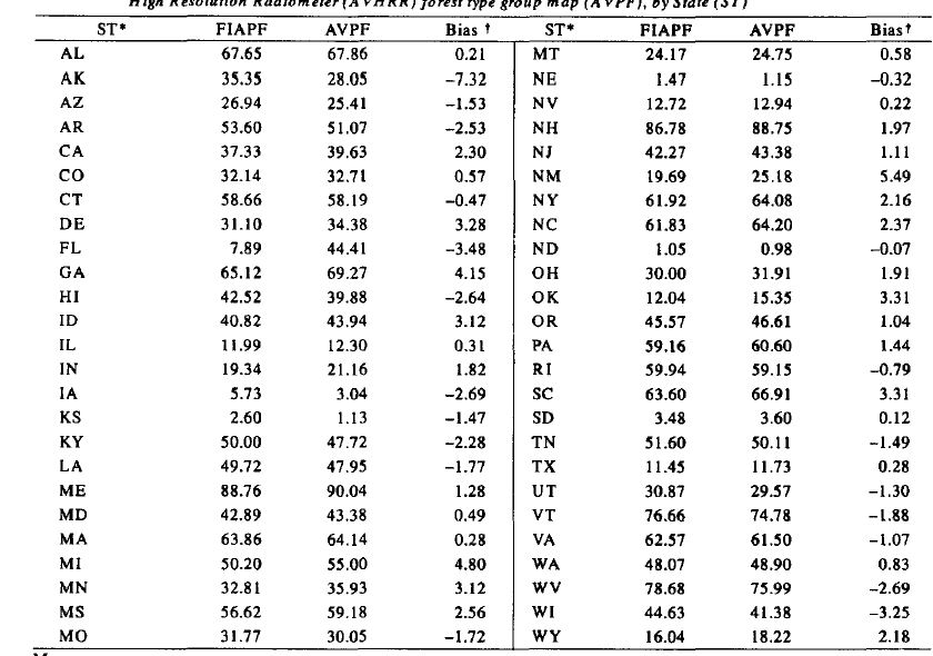
Hoosier - I'm talking about % of trees relative to a square mile area. Of course there are trees in Oklahoma, but... Surely that data exists. A quick topographical glance into Google Earth can also verify. Or, here's a study: http://www.treesearch.fs.fed.us/pubs/194 Look at the forestation density (near the end of the .PDF) of Alabama versus Oklahoma. The PDF is a good glance through, and you'll notice a picture and a table.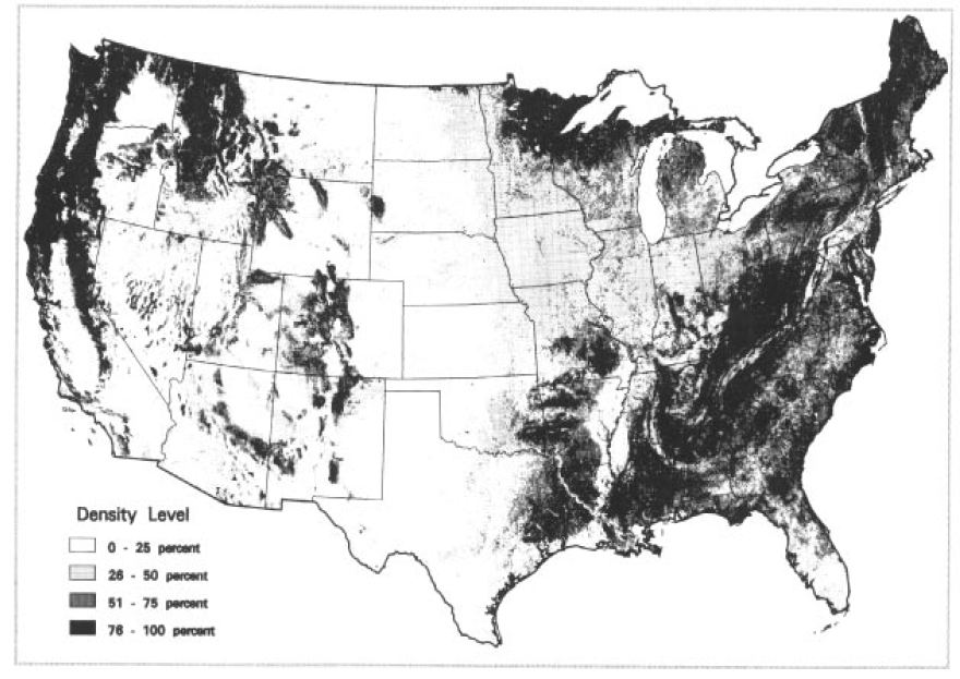
-
Devastating tornado strikes Joplin, Missouri
SluggerWx replied to Hoosier's topic in Weather Forecasting and Discussion
I would honestly rather them say "OMG - WORST TORNADO EVERR RECORDED ON EARTH" and have that be the entire article with any of the devastating pictures from Joplin. Seriously. If that were the headline in the paper or on news websites for a week, maybe people would FINALLY start paying attention! We can't make most Americans like us, so maybe we should just translate into phrases and sentences they understand? -
Devastating tornado strikes Joplin, Missouri
SluggerWx replied to Hoosier's topic in Weather Forecasting and Discussion
Most would rather be the 'Mayor' of a local coffee shop or pizza place on 'Foursquare' for their mobile device instead of paying $250 and then figuring out just HOW to use GR2AE. Now, if we made GR2AE significantly 'dumber' and basically called it 'Tornado Tracker,' and I mean REALLLLY easy, we might have a shot. I don't think the market is there for that type of development (and not to knock any/all weather software products out there currently) - they're top notch. Maybe the NWS will buy Gibson Ridge and make a mobile, dumbed down version of GR2AE available for all to use on their devices and peg it to their GPS. If only we could make that happen... -
Devastating tornado strikes Joplin, Missouri
SluggerWx replied to Hoosier's topic in Weather Forecasting and Discussion
Sadly, everyone, nobody is going to pay attention nationally aside from 'next-day' news coverage or whatever pops up on their Yahoo Messenger newspage that opens up when they open messenger upon arriving at work. I'm sure this is why they'll upgrade Joplin to an EF-5 tomorrow so the 'next-day' press parade/lurkers doesn't go out to the 'sensational EF-5.' The boots on the ground are in rescue/recovery mode and you had better imagine there would be 10x more folks in Joplin, MO tomorrow if it were rated an EF-5 today than will be in Joplin, MO on Wednesday if it's upgraded to an EF-5 tomorrow. Same reason the pretty blonde that goes missing gets wall to wall coverage on the news while ten other girls go missing without a mention. The news is still, at the core, driven to bring in revenue (not that all it's reporters/staff feel that way). Until someone sustains coverage in the MSM or a big political figure (or President) takes advocacy to realize tornadoes ARE a risk to national security, those in the affected areas, we weather geeks and good-hearted volunteers are really the only folks that will be paying attention here. This is why I've said that although Stormchasers is a total drama-fest on The Discovery Channel to most weather fans, it's probably doing more to attract attention to Tornadoes than nearly anything else. If the government provided tax breaks to any employer who allowed their employees to go assist with these natural disasters, maybe most hard-working Americans would be able to step outside of the day-to-day haze of a Monday - Friday job and join in the effort to make a difference. Now, millions of people would watch SevereStudios on Comcast or DirecTV (or ChaserTV for that matter) if they only knew it existed and video quality was slightly upgraded. That would be a way to increase exposure/interest in SevereWX. For business reasons, they'll get the revenue. For our reasons, we'll have some access to that revenue to actually try and help save lives. Sorry for the long post, but that's my take on why more Americans know about Snookie or the Kardashians than know about severe weather and it's threat. -
Devastating tornado strikes Joplin, Missouri
SluggerWx replied to Hoosier's topic in Weather Forecasting and Discussion
A lack of trees over a broad area. Two reasons supporting that hypothesis: 1) Visibility. Monster tornadoes cannot be identified as monster tornadoes if you have three or even five trees within your close proximity. You see a giant black cloud that might appear as a squall line...and it's a giant tornado instead 2) Thousand Pound Missiles: Trees become hundreds or even thousands of 10 lb. to 2-5 ton projectiles that fly 150 - 200 MPH through the air in multiple directions. If a tree penetrates a brick wall, the bricks then become part of a giant 200MPH floating blender. If a tree compromises the foundation of a home, air can then penetrate/lift the home. This is why we've seen more deaths in the SE tornadoes and now Joplin. Look at any 'before' shot of Joplin and you'll see trees everywhere. I'd imagine we'd identify that the most east points of these city areas that have been destroyed have been hit by not just trees in their yard...but trees from a mile back, then the trees from 1/2 mile back and then the trees from 500 yards back...etc. Greensburg/Parkersburg also had several trees throughout their towns. -
Devastating tornado strikes Joplin, Missouri
SluggerWx replied to Hoosier's topic in Weather Forecasting and Discussion
Really sad story on Piers Morgan... live phone interview with an attorney in Joplin - Aunt posted on Facebook "Oh my God" before it hit. Both his Aunt/Uncle passed away in this storm. This is tragic, and technology is allowing us too eerily communicate with those directly in the path of storms. Do you all know if any IT forensic studies were done in Tuscaloosa with recovered cell phones/cameras? I imagine there are quite a few videos from victims of these storms that we never end up seeing because they don't make it. Think of how many folks like the 'Duarte' Tuscaloosa video cap probably also recorded, but unfortunately fell victim to the storm as it jarred or turned directly at them... -
Reconsider majoring in meteorology!
SluggerWx replied to stormguy80's topic in Weather Forecasting and Discussion
My International Biz teacher from China had 7 patents on dialysis machines... eventually left the science side when sales VPs/COs of said med tech sales firms were banking on his invention. He left and got an MBA in London around the age of 35, then he went to another med-tech firm to be the COO... Millions later, he definitely insisted we take his later route (business), sooner. IMO, the OP needs to understand its not a great life to be a met (or any type of science) if you are even going to introduce the idea of financial compensation into the decision-making process. Go into the private sector with your ideas and your met degree and make a ton of money...I have only a business background and I follow weather as a hobby. If the NWS provides my business needs with as much free info as I need, of course the market for 'mets' is low... Show my business how you can provide me with something my tax dollars don't, and I'll pay you what your value prop is worth. IMO, the OP is backwards. The state of affairs is perfect for people to innovate, create and discover in met....instead of working in a local weather office cranking out forecasts, you are creating new ideas and advancing technology. It couldn't be a better time to have a degree in met, actually. The internet is making people far more in tune with weather, and there are enormous opportunities to enjoy a successful career in nearly every industry by having a degree in met... What other factor, besides weather, does everyone in the world have to factor in to their daily plans in some way, shape or form? That's why I tell the sales team I manage to bring up weather if they're having a tough time breaking the ice with a client - it never fails. using Tapatalk -
Historic Tornado Outbreak April 27, 2011
SluggerWx replied to CUmet's topic in Weather Forecasting and Discussion
I didn't clearly state my point... so allow me to do so here. The weather behind this event cannot be compared to the weather from 1974. It's not a discussion that's relevant or adds value to the trauma and carnage that happened yesterday. If you want to say the weather system in 74' was more widespread - that's accurate. And, the energy behind my original response to you was meant to say 'bring this elsewhere.' Any post that tries to compare a historic event to the events that unfolded in the last three days isn't really giving the respect to what happened and what's still happening. Why bring that in here when your knowledge could clearly analyze, compare and dissect the events that happened THIS year - not 1974. Let's give this some time before we look back to comparing any part of this to 74.' More value in looking at what's going on today... It's just my opinion. -
Historic Tornado Outbreak April 27, 2011
SluggerWx replied to CUmet's topic in Weather Forecasting and Discussion
Image 20 is too much for words. I would hope before publishing this picture that the photographer identified if the victim in the red car had already been removed from the red car. If not, this is not something the photographer should NOT post online. Clearly there was a life-taking or life threatening serious injury within this car. -
Historic Tornado Outbreak April 27, 2011
SluggerWx replied to CUmet's topic in Weather Forecasting and Discussion
This is not a met perspective. F5 in the 1970s is to '_____' on the Enhanced Fujita scale? How much knowledge did those folks surveying damage in 1974 have compared to what they have now? In every industry, we are light years ahead of where we were in 1974. To say an F5 tornado in the 70s has any relevance to how a tornado is rated today (if comparing intensities), is short-sighted - and irrelevant. I would think the met point of view here would actually argue opposite your point. Unless you can run a GRLevelx scan of the 74 outbreak using today's Doppler's and computer technology, and THEN go survey the damage with homes built exactly the same, from the same building materials...Why even bring up the Fujita intensity rating of something that happened over 35 years ago and relate it to how well the two systems stack-rank met-wise against one another? -
Historic Tornado Outbreak April 27, 2011
SluggerWx replied to CUmet's topic in Weather Forecasting and Discussion
All... I'm seeing a lot of slaps with debris surrounding a barren slab in the Cartersville, GA aerial damage surveys... http://www.myfoxatla...-20110427-am-sd Can someone with a little more professional POV on EF-intensity/scale give a hypothesis surrounding projected EF-scale for the Cartersville tornado? This is far worse damage than Murfreesboro, TN (rated EF-4) because JUST the slab remains on many of these homes.... Probably not as wide as Greensburg (maybe so), but definitely the same 'slab only' profile with some of the damage I'm seeing at the above link.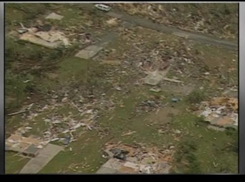
-
Historic Tornado Outbreak April 27, 2011
SluggerWx replied to CUmet's topic in Weather Forecasting and Discussion
Good morning all... I compiled the below list last night for everyone's reference... Tuscaloosa: http://vimeo.com/22970879 Tuscaloosa http://www.twitvid.com/93O7M http://www.twitvid.com/4W6PU Birmingham: Cullman County http://www.youtube.com/watch?v=6U1asLiDYB0&feature=player_embedded MS [/url]MS: Arkansas: Chatt, TN: -
Historic Tornado Outbreak April 27, 2011
SluggerWx replied to CUmet's topic in Weather Forecasting and Discussion
All - Georgia usually delays their reports somewhat... You're going to see a significant number of tornadoes 20-40 added to these totals. I assume we'll also see the same case with fatalities. I will go to sleep now and pray I'm wrong...unfortunately scanner radio reports this evening over GA tell me I have a lot of praying to go do. -
Historic Tornado Outbreak April 27, 2011
SluggerWx replied to CUmet's topic in Weather Forecasting and Discussion
Is the cell near Union, West Virginia still producing (question 1)? QUESTION 2: IS THIS THE SAME CELL THAT HIT CATOOSA, GA??? What's the longest track on record? This would double it, I'm thinking? Or, do we think the Tusc, Birm, Rome, Jasper (now into VA) cell retained it's track? Just an observation. -
Historic Tornado Outbreak April 27, 2011
SluggerWx replied to CUmet's topic in Weather Forecasting and Discussion
There were more textbook strong tornadoes on RADAR today that lived FOREVER, in my opinion, than one can imagine. It's like there were 8-12 'Yazoo City' tornadoes in one day. -
Historic Tornado Outbreak April 27, 2011
SluggerWx replied to CUmet's topic in Weather Forecasting and Discussion
Here's a webcam from the Brasstown Bald observatory...Brasstown is the highest point in Georgia. http://www.fs.usda.g...0Forest-%20Home This is pretty epic watching this webcam because I know there are very sparsely populated beautiful mountains here. This is where tornadoes should hit if they must hit somewhere. Can anyone screen cap anything they can make out on the cam? -
Historic Tornado Outbreak April 27, 2011
SluggerWx replied to CUmet's topic in Weather Forecasting and Discussion
I played 2 years of baseball at Young Harris (between Hiawassee and Blairsville below), but I still hold this part of northern GA close to my heart... Missed YHC, but this thing might be nailing 'Brasstown Bald.' I imagine the observatory at brasstown bald is going to be no more.. This thing is tracking right at Western Carolina University within about an hour- 1 1/2 hours.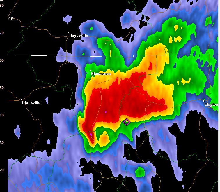
-
Historic Tornado Outbreak April 27, 2011
SluggerWx replied to CUmet's topic in Weather Forecasting and Discussion
Touchdown on HWY 140 (Bartow Co) just now. Heading into Northwestern Cherokee, then to pickens/dawson. Confirmed per Scanner Radio. Then I heard the tragic...coroner is in route. This is all breaking right now in Bartow as that cell just passed through. -
Historic Tornado Outbreak April 27, 2011
SluggerWx replied to CUmet's topic in Weather Forecasting and Discussion
They are searching a street half a block away from Ringold High School because houses are leveled. -
Historic Tornado Outbreak April 27, 2011
SluggerWx replied to CUmet's topic in Weather Forecasting and Discussion
3 Fatalities on Catoosa scanner ...just relayed on scanner. 3 confirmed 10-109D's. This is a nightmare. -
Historic Tornado Outbreak April 27, 2011
SluggerWx replied to CUmet's topic in Weather Forecasting and Discussion
All...GA radio has the Catoosa Hotel being on exit 348, which is Ringold, which is populated. Google Maps tells us this is a Super 8, Holiday Inn Express or the Baymont Inn and Suites... Restaurants were also mentioned with the term 'leveled.' Praying. -
Historic Tornado Outbreak April 27, 2011
SluggerWx replied to CUmet's topic in Weather Forecasting and Discussion
Three story hotel in Catoosa County, GA 'collapsed.' Per WSBTV. -
Historic Tornado Outbreak April 27, 2011
SluggerWx replied to CUmet's topic in Weather Forecasting and Discussion
Would this constitute a 'debris ball?'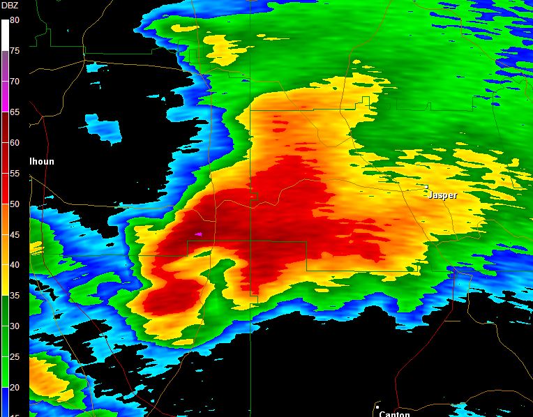
-
Historic Tornado Outbreak April 27, 2011
SluggerWx replied to CUmet's topic in Weather Forecasting and Discussion
Wow. Please be safe and miss Reinhardt (univ.)!!!! This is scary, about 5 minutes old but here's what it looked like sorry for the transparency... to my desktop!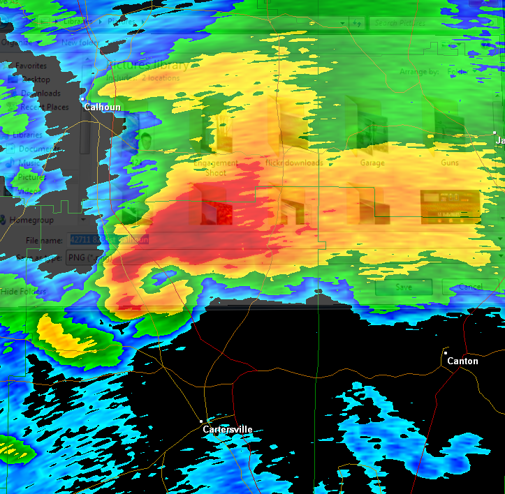
-
Historic Tornado Outbreak April 27, 2011
SluggerWx replied to CUmet's topic in Weather Forecasting and Discussion
Glenn Burns in ATL says a storm in Anniston, AL has a BTI of 9.9 out of 10? http://www.wsbtv.com/video/27695563/index.html
