

RodneyS
-
Posts
1,256 -
Joined
-
Last visited
Content Type
Profiles
Blogs
Forums
American Weather
Media Demo
Store
Gallery
Posts posted by RodneyS
-
-
DCA finished January 2023 with the third warmest (of 153 years) January average temperature in DC -- 45.2 degrees. January 1950 is # 1 at 48.0 and January 1932 is # 2 at 46.8.
-
 1
1
-
-
On 1/27/2023 at 8:34 AM, RodneyS said:At the beginning of this winter, January 27th marked the latest day of any Dulles Airport winter season (dating to 1962-63) for the first measurable snow -- on that day in 2009, IAD ended its 2008-09 snow drought by recording 2.0 inches. We shall see when (or should I say if ?
") ) the IAD snow drought ends this winter.
FYI, in both Baltimore and Washington, the latest first measurable snow of any winter season occurred during 1972-73, when BWI recorded its only measurable snow on February 21, 1973 (1.2 inches) and DCA did the same on February 23, 1973 (0.1 inch). In Richmond, the long-ago winter of 1918-19 resulted in a season-long snow drought -- only a trace fell (in December 1918 and January 1919).
) the IAD snow drought ends this winter.
FYI, in both Baltimore and Washington, the latest first measurable snow of any winter season occurred during 1972-73, when BWI recorded its only measurable snow on February 21, 1973 (1.2 inches) and DCA did the same on February 23, 1973 (0.1 inch). In Richmond, the long-ago winter of 1918-19 resulted in a season-long snow drought -- only a trace fell (in December 1918 and January 1919).The IAD snow drought made it until Tom Brady's second retirement, and so February 1st is the new record for the latest day of any Dulles Airport winter season for the first measurable snow. I presume DCA also received measurable snow this morning-- BWI I'm not sure about. In any event, when the totals are announced, I will post an updated table -- not that it will change the relative standings, which show Little Village Wx with a comfortable lead.
-
1
-
-
DCA _ NYC _ BOS __ ORD _ ATL _ IAH ___ DEN _ PHX _ SEA
1.5 2.1 1.4 2.4 1.5 1.0 -1.6 -1.8 -1.6
-
 1
1
-
-
At the beginning of this winter, January 27th marked the latest day of any Dulles Airport winter season (dating to 1962-63) for the first measurable snow -- on that day in 2009, IAD ended its 2008-09 snow drought by recording 2.0 inches. We shall see when (or should I say if ?) the IAD snow drought ends this winter.
FYI, in both Baltimore and Washington, the latest first measurable snow of any winter season occurred during 1972-73, when BWI recorded its only measurable snow on February 21, 1973 (1.2 inches) and DCA did the same on February 23, 1973 (0.1 inch). In Richmond, the long-ago winter of 1918-19 resulted in a season-long snow drought -- only a trace fell (in December 1918 and January 1919).
-
2
-
4
-
-
On 1/21/2022 at 9:06 PM, RodneyS said:Recent DCA temperatures offer more support for the "January 13th thaw-January 21st freeze" hypothesis, with the former day in 2022 averaging 41.5 degrees and the latter day averaging 23.0 degrees. The new NCDC 1991-2020 DCA normals now reflect a bottoming out of yearly temperatures in the January 18th-22nd time frame (at 37.0 degrees), with January 13th 0.2 degrees higher. The previous 1981-2020 normals showed a bottoming out right around January 13th (at 35.7 degrees), with January 21st 0.2 degrees higher. While this update is a step in the right direction by NCDC, it does not come close to reflecting the reality that during 1991-2020 at DCA January 13th temperatures averaged 9.0 degrees higher than January 21st (41.6 vs. 32.6).What convinces me that this differential is not merely a weird aberration, but rather an unexplained phenomenon, is that I first noticed it nine years ago, and it has continued. Specifically, during the last nine years (2014-2022), January 13th temperatures at DCA have averaged 6.7 degrees higher than January 21st (40.4 vs. 33.7). While this differential is not quite as high as during 1991-2020, my first calculation of the differential was for the period 1984-2013, when it averaged 8.2 degrees (40.3 vs. 32.1). So, the differential actually increased when that 30 year period was moved forward by seven years to 1991-2020, and while it has been somewhat lower during the most recent nine years, it is still for those nine years way beyond what would be expected if 1984-2013 had been an aberration.What is particularly interesting about all of this is that for the first 112 years of official daily temperature recordkeeping in DC (1872-1983), there tended to be a January 13th freeze and a January 21st thaw. Specifically, during that time frame, January 13th averaged 3.5 degrees cooler than January 21st. So, while for the most recent 39 years in DC, January 13th has averaged 7.0 degrees warmer than for the first 112 years (40.3 vs 33.3), January 21st has averaged 4.3 degrees cooler (32.5 vs 36.8). Why the big shift? Inquiring minds want to know.
The beat goes on. This year January 13th averaged 47.5 at DCA, while January 21st averaged 39.0. So, the comparison of the average temperature for the two days between the first 112 years of official daily temperature recordkeeping in DC and the last 40 years is as follows:
Period Jan 13 Jan 21 Jan 21 minus Jan 13
1872-1983 33.34 36.77 +3.43
1984-2023 40.49 32.65 -7.84
-
1
-
1
-
-
12 minutes ago, PrinceFrederickWx said:
I had mentioned both those winters in the snow futility thread when researching DCA shutouts. Those were both interesting years. Thanks for the info!
It's uncanny how similar those two winters were. Of course, both are considered by NOAA to be neutral years, rather than La Nina years; see https://psl.noaa.gov/enso/past_events.html
-
1
-
-
4 hours ago, PrinceFrederickWx said:
I'm still liking where I sit, my proprietary PFWx model says we get our one and only WSW event in the 2nd half of March. I'll see you then.
")
Okay. FYI, an astonishing historical DC snow fact is this:
In the winter of 1913-14, no measurable snow fell until February 13, 1914. Then a Valentine's Eve/Valentine's Day storm dropped 4.5 inches. That seemed to open the snow gates, as after that snow fell on an additional nine days through March 22, 1914, resulting in 28.6 inches for the season, of which a record 19.3 inches fell in March.
Now fast forward to the winter of 1959-60. Believe it or not, once again no measurable snow fell in DC until February 13th, and once again a Valentine's Eve/Valentine's Day storm dropped significant snow -- this time, 6.2 inches. And once again, that seemed to open the snow gates, as after that snow fell on an additional seven days through March 16, 1960, resulting in 24.3 inches for the season, of which 17.1 inches fell in March -- the second most ever -- second only to March 1914.
-
5
-
1
-
-
12 hours ago, PrinceFrederickWx said:
Well this has been an easy contest for Rodney to run so far

At this point, both you and I are wishing that we had low-balled @Little Village Wx.
") However, snow lovers who are Washington Post subscribers can console themselves by consulting their archives and reading a January 20, 1987 article written by Mary Jordan titled "Snow Hopes Dashed" (p. B1). The article stated, among other things: " . . .(DC) residents were still waiting yesterday for the area's first measurable snowfall . . . Rain and temperatures above freezing were expected during the rest of the week, the National Weather Service said."
However, snow lovers who are Washington Post subscribers can console themselves by consulting their archives and reading a January 20, 1987 article written by Mary Jordan titled "Snow Hopes Dashed" (p. B1). The article stated, among other things: " . . .(DC) residents were still waiting yesterday for the area's first measurable snowfall . . . Rain and temperatures above freezing were expected during the rest of the week, the National Weather Service said."
Two days later, DCA recorded 10.8 inches of snow. Three days after that was Super Bowl Sunday, and an overnight storm dropped another 9.2 inches of snow. The Federal Government was closed on Monday, but Tuesday afternoon, January 27, 1987, produced perhaps the most epic traffic jam in DC history, as the 20 inches of snow on the ground and the temperature range of 9 to 30 at DCA proved too much for the (three?
 ) DC snowplows to overcome during the PM rush hour. (I know because I was in that traffic jam.) When that snow was finally removed and things were back to normal, February 22-23 saw another two-day storm that dropped an additional 10.2 inches at DCA.
Am I saying that the above scenario will repeat this year? . . . Of course not, only Jebman would say that.
-
4
-
-
22 hours ago, RodneyS said:
The 60+ degree weather streak at DCA to begin the New Year has reached a DC record five days. However, that streak will almost certainly end today, and so will not challenge the more general eight-day January 60+ degree streak that began on January 2, 1998.
The 60+ degree weather streak has ended, but it established a DC record for the first five days of the year for both average maximum and average mean temperatures. January 1-5, 2023 averaged a 65.0 maximum, breaking the January 1-5, 2000 record of 62.3; and a 55.6 mean, breaking the January 1-5, 1950 record of 54.5.
-
On 1/4/2023 at 10:21 AM, RodneyS said:
Today at DCA marks four straight days with 60+ readings. As I noted yesterday, no calendar year in DC had ever previously begun with even three straight 60+ readings. However, in 1998, after New Year's Day peaked at only 35 at DCA, eight straight days (January 2-9) reached at least 60.
The 60+ degree weather streak at DCA to begin the New Year has reached a DC record five days. However, that streak will almost certainly end today, and so will not challenge the more general eight-day January 60+ degree streak that began on January 2, 1998.
-
1
-
-
13 hours ago, RodneyS said:
After our Christmas weekend freeze, January so far has been a thaw and then some: Today marked the third straight 60+ degree reading at DCA, which had never previously happened in DC weather history to begin the year.
Today at DCA marks four straight days with 60+ readings. As I noted yesterday, no calendar year in DC had ever previously begun with even three straight 60+ readings. However, in 1998, after New Year's Day peaked at only 35 at DCA, eight straight days (January 2-9) reached at least 60.
-
1
-
-
After our Christmas weekend freeze, January so far has been a thaw and then some: Today marked the third straight 60+ degree reading at DCA, which had never previously happened in DC weather history to begin the year.
-
1
-
-
DCA _ NYC _ BOS _ ORD _ ATL _ IAH _ DEN _ PHX _ SEA
2.6 3.5 3.5 3.7 1.6 2.7 -0.3 -0.7 0.3
-
1
-
-
Thank you, thank you very much.
-
I agree, and I think the main problem is that many people don't have the time to devote to a monthly contest. However, it's a lot of fun for those of us who are able to set aside the time each month.
-
1
-
1
-
-
7 hours ago, RodneyS said:
I just posted this on the Capital Weather Gang page:
Yesterday's 43-degree temperature range at DCA (55 maximum, 12 minimum) was the widest in exactly 24 years and one day, and tied for the 13th widest in DC history. On December 22, 1998, the mercury plunged from a high of 67 to a low of 24. The widest range ever in DC was March 22, 1907 when the temperature rose from a morning low of 40 to an afternoon high of 90.
DCA and IAD have each reached what appears to be their maximum temperatures of 22 degrees for today, which breaks the 1989 Christmas Eve record low maximum of 23 at DCA and ties the 1989 Christmas Eve record low maximum at IAD.
-
2
-
-
I just posted this on the Capital Weather Gang page:
Yesterday's 43-degree temperature range at DCA (55 maximum, 12 minimum) was the widest in exactly 24 years and one day, and tied for the 13th widest in DC history. On December 22, 1998, the mercury plunged from a high of 67 to a low of 24. The widest range ever in DC was March 22, 1907 when the temperature rose from a morning low of 40 to an afternoon high of 90.
-
3
-
-
On 7/9/2022 at 7:06 PM, RodneyS said:Today is the rainiest at DCA since September 30, 2010, and is currently the 22nd rainiest day in DC history. It could move up a little further, with some evening rain. Figures are in inches:1) 6.39 August 23, 1933 (Wednesday)2) 6.14 August 2, 1944 (Wednesday)3) 6.11 June 21, 1972 (Wednesday)4) 5.97 August 11, 1928 (Saturday)5) 5.44 August 12, 1955 (Friday)6) 5.19 June 25, 2006 (Sunday)7) 5.16 September 2, 1922 (Saturday)8) 4.92 August 12, 1898 (Friday)9) 4.83 August 20, 1963 (Tuesday)10) 4.76 September 16, 1976 (Thursday)11) 4.69 July 9, 1970 (Thursday)12) 4.66 September 30, 2010 (Thursday)13) 4.49 September 4, 1939 (Monday)14) 4.45 September 5, 1935 (Thursday)15) 4.35 July 22, 1969 (Tuesday)16) 4.25 July 30, 1878 (Tuesday)17) 4.22 June 26, 2006 (Monday)18) 4.16 June 22, 1886 (Tuesday)19) 4.15 September 16, 1874 (Wednesday)20) 4.12 July 30, 1876 (Sunday)21) 4.07 September 14, 1966 (Wednesday)22) 4.05 July 9, 2022 (Saturday)23) 4.03 August 8, 1942 (Saturday)24) 4.02 September 12, 1934 (Wednesday)25) 4.00 July 21, 2018 (Saturday)While today's DCA total of 1.88 inches is a long way from any of the above days, it is the wettest winter (astronomical or meteorological) day in exactly four years. December 15, 2018 established the record for this calendar day with 2.55 inches.
-
I will keep track of your forecast, and will award you honorary membership in the Mid-Atlantic Snow Forecast Contest Hall of Fame, if your entry would have won. In the meantime, mark your calendar for Friday, December 1, 2023, which will be the deadline for next year's contest.
-
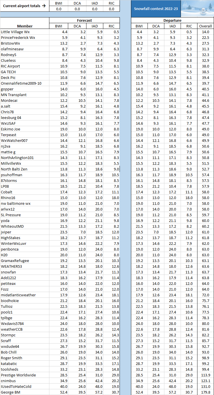
For the 2022-23 snow season contest, we have 64 entrants, up from 59 in 2021-22. Assuming that none of last season's entrants changed their user names, 48 entrants this season are returnees and 16 are new. Note that 2021-22 winner IUsedToHateCold is looking for a big snow season, after correctly foreseeing a rather run-of-the-mill season in 2021-22. The average amount forecast for the four airports combined this season is 63.3 inches, with a median of 58.9 inches.Here is the list, in ascending order of combined forecast snow. If you see any errors, please advise.
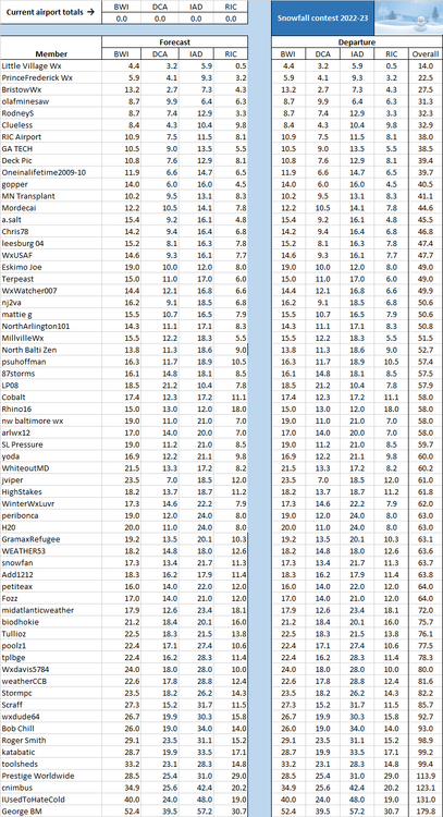
-
2
-
5
-
-
2 hours ago, WhiteoutMD said:
BWI: 21.5"
DCA: 13.3"
IAD: 17.2"
RIC: 8.2"
Do you have a tiebreaker selection?
-
Final Call -- deadline is this evening at 11:59 PM EST. We have 60 so far, but 14 folks who participated last year have not yet entered.
-
1
-
-
DCA _ NYC _ BOS ___ ORD _ ATL _ IAH ____ DEN _ PHX _ SEA
-1.1 -0.2 0.2 -1.3 -0.3 2.4 1.4 0.4 -2.8
DCA _ NYC _ BOS ___ ORD _ DTW _ BUF ___ DEN _ SEA _ BTV
7.4 33.0 50.0 44.0 48.0 93.0 46.0 7.0 98.0
-
1
-
-
11 hours ago, Add1212 said:
BWI: 18.3
DCA:16.2
IAD:17.9
RIC:11.4Do you have a tie-breaker selection?
8th Annual Mid-Atlantic Snowfall Contest
in Mid Atlantic
Posted