

ryan1234
-
Posts
357 -
Joined
-
Last visited
Content Type
Profiles
Blogs
Forums
American Weather
Media Demo
Store
Gallery
Posts posted by ryan1234
-
-
3 minutes ago, LithiaWx said:
True, never let your guard down but from this map I see a GA and WNC being the most under the gun in the forum. Dynamics must be much less impressive for central and eastern NC.
Definitely, agree. However, if this thing speeds up, it might end up catching many by surprise. But this might up being one of those I-85 specials. If I were within 50 miles of 85, from just east of the AL/GA line to Charlotte and up to the Triad... I'd be ever so slightly nervous. Our area is well overdue for an outbreak.
-
 1
1
-
-
If things stay the same, I expect we'll see a high risk with this one. The SPC day 1 criteria for high risk (45% with sig severe) would be reached.
They make Saturday’s event seem more of an issue, than Sunday’s. That’s kinda surprising. Although, timing of the day may make it less of an issue than areas west of the Triangle. I definitely wouldn’t let me guard down anywhere in the Carolina’s for Sunday. It’s quite an impressive setup.
.
-
Another good read for Sunday's event. Very active period upcoming. Once again, I feel like GSP AFD are the best in the country. Compared to many others. They really do a great job!
Area Forecast Discussion
National Weather Service Greenville-Spartanburg SC
253 PM EDT Thu Apr 11 2019

.SYNOPSIS...
A cold front bringing showers and thunderstorms to the region will
approach from the west on Friday and stall across the area on
Saturday. A second stronger system will bring storms to the area on
Sunday and Sunday night.

&&

.NEAR TERM /THROUGH FRIDAY/...
As of 230 pm EDT: A Wind Advisory has been posted for tonight at
elevations above 3500 feet in and around the Great Smoky Mountains.
There is good consensus of 50+ kt 850 mb flow in and near the
Smokies which should provide for decent high elevation gusts despite
the warm advection regime.

Weather conditions are expected to deteriorate through the near-term
forecast period as Atlantic and then Gulf moisture begin to converge
on the area. The stacked low pressure system over the central plains
this afternoon will migrate slowly over the upper Midwest tonight
through Friday. Meanwhile, boundary layer moisture will increase in
the southeasterly low-level flow tonight between offshore high
pressure and the strong cold front advancing into the MS River
Valley. Upslope cloudiness will quickly develop, similar to this
morning, but deeper moisture and better forcing will permit
blossoming rain showers, especially along the Blue Ridge around
midnight, and eventually across much of the area by daybreak.
Anticipate that the upslope precipitation will maximize overnight
into Friday morning, but with PoPs then transitioning into the
piedmont through the afternoon as deep layer southwesterly flow sets
up. In addition, upper-level divergence will improve from the west
over the mountains Friday afternoon to keep PoPs going there, while
instability and weak triggers will provide for better convective
coverage along the I-77 corridor through the latter part of the day.
At peak heating, sbCAPE values of 1000 to 1500 J/kg are likely east
of the mountains, but mid-levels remain fairly warm so thunderstorms
should be mostly garden variety. Anticipate very warm mins some 15
degree or more above climo overnight, with maximum temperatures one
to two categories above climo despite the clouds Friday afternoon.

&&

.SHORT TERM /FRIDAY NIGHT THROUGH SUNDAY NIGHT/...
As of 200 PM Thu: As a mature low pressure system moves across the
central Great Lakes Friday night, a cold front will lay out along the
southern Appalachians per NAM/GFS. The EC depicts it making it past
the mountains, but the general expectation is that the front`s
progression into our area will be limited by the deep ridge over the
Southeast coast and western Atlantic, and as the next system develops
over Texas along the southern end of the front. Thus, we effectively
will be in the warm sector of the Great Lakes system overnight into
Saturday. Some degree of elevated instability will persist during
this time, within a juicy springtime airmass characterized by
Piedmont/valley temps in the 70s and dewpoints in the 60s. Except for
relatively weak isentropic upglide, however, there may not be much of
a triggering mechanism. A low PoP (and in many areas thunder) will
remain in the fcst. Deep-layer shear still will be in play on account
of a modest upper jet, so the potential does exist for a couple of
stronger cells producing marginally severe hail and wind,
particularly during peak heating Saturday afternoon.

Instability will wane again Saturday night. The aforementioned Texas
system will move into the mid-Mississippi Valley, tracking along the
Ohio River Sunday. The base of the parent shortwave will swing across
the Deep South. As 850mb flow increases ahead of it, precip again
will blossom along the Escarpment. Instability will redevelop after
daybreak Sunday, with similarly warm/moist sfc conditions. This is
particularly concerning given the increasing 850mb flow, culminating
in the 50-60 kt LLJ appearing likely to translate across the area as
sfc based instability peaks.  0-3km shear accordingly will be similar
in magnitude, and with hodographs above that layer being fairly
straight, QLCS segments appear to be a preferred storm mode. SHERB
values calculated from the GFS peak above 1 across the Piedmont.
Timing differences previously had limited our confidence, but the
latest 12z ECMWF is a little faster than the previous run, bringing
it more in line with the other synoptic models. There remain some
differences in how backed sfc winds will be, which keeps confidence
low as to the degree of tornado threat we will experience.
Nonetheless we anticipate parts of our CWFA will continue to be
highlighted for severe risk (esp. damaging wind) on the SPC outlooks
as we approach Sunday. As the low moves by to our north Sunday night,
the cold front will push through the area, and prog soundings suggest
we won`t totally be out of the woods for severe weather until that
occurs; it is possible we will have two rounds of activity, one
during peak heating and another immediately along the cold front. Of
course the latter will depend on how much energy remains following
the first round.

Much cooler temps will return to the mtns behind the front Monday
morning; precip most likely will end before any of it is able to
change to snow or produce rime ice.

&&

.LONG TERM /MONDAY THROUGH THURSDAY/...
As of 115 PM EDT Thursday: With the timing of the dry slot
overspreading the region still slated for Sunday night, progressive
drying within the post-frontal airmass is on tap for Monday.  Within
the well-mixed environment, max temperatures will average a few deg
F below the mid-April climo. Atop the SE CONUS for Tuesday, expect
rising upper heights and the passage of a llvl ridge axis providing
another dry day. Developing llvl return flow will boost maximums
well into the 70s.

Throughout Wednesday, as energy ripples eastward from the Southern
Plains and interacts with an increasing gulf moisture tap,
widespread convective rainfall is progged to blossom acrs the gulf
states. The preferred EC mass fields solution keeps pcpn chances
west/sw of the cwfa into Wednesday evening, so sensible wx for us
should be limited to just an increase in clouds and a further boost
to maximums. With deeper level forcing impinging upon the region
next Thursday, robust deep convection has the potential to become
widespread, stay tuned.
-
28 minutes ago, vman722 said:
Agreed. Also think the sometime around the 18th does as well. Euro and GFS both have a very nice looking troughs with deep surface lows coming into a similar location as the one this weekend. Two active looking periods to watch no doubt. Interested to see if the gulf can recover in time after the first system. Like the look of the 850's for both systems. AL/MS def should be watching those.
Yes, I saw that as well. Definitely not a dull time period coming up, that's for sure. AL and MS should absolutely pay attention. But I wouldn't let my guard down either if I were in GA or the Carolina's. Without any wedging, (besides a few other details) that can't keep these storms going further east. Especially in an El-Nino spring.
-
This weekend looks interesting (if you're into severe weather). The forecast discussion from GSP is worth a read as well. Looks like the majority of us will have something to track, especially by Sunday.
-
3
-
-
The local Mets are really downplaying this. As if it’s a nothing event. I could very well still be, but you’d think a few would be talking about it possibly being more.
. -
If only we could get some more suppression. I really would love to see folks in CAE and Raleigh (south of 85) score as well. Although, I would take this map any day.
. -
Ah ok I didnt know it went that low today. I do remember it snowing in Lancaster and Palmdale several times when I lived out there. That's a little higher up though
Yeah, according to friends and family, snow was reported in Pasadena, West Hollywood, and Malibu. Pretty amazing. I think Palmdale and Lancaster even had an inch or so. But yeah, they are high desert cities, so snow does occur every now and then.
. -
I get what your saying but LA has mountains at 10k elevation. You can see snow on mountains from the beach on clear days in the winter.
Assuming LA = Los Angeles.
Very true. As someone who used to live there you can definitely see snow on the local peaks. However, Malibu saw snow today as did other valley locations.
. -
It’s quite a slap to the face when snow is falling in LA’s higher elevations. Meanwhile, there are still quite a few of us who haven’t even seen a flake on this board.
. -
Calling off winter 7 days into February is a bit ridiculous and premature. No,the pattern doesn’t bode well in the next week or so. But given how poorly models have handled winter thus far, I’m not giving them much credibility. We’ve had snow well into February and March. So, quit whining about something that could very well change within a few weeks.
.-
1
-
-
It is this day and age. Always happens every year now. This is the hardest place in the se to snow.
I mean technically we should be receiving double if not, triple of what Atlanta sees. So it’s odd. But I can’t argue with you, because I’m beginning to think you’re right. A lot of you got a good snow in December. I got maybe a dusting and a little bit of ice.
. -
I’m surprised there aren’t more Carolina peeps on this page. It’s not that often that it snows that far south in Mississippi, only to leave us high and dry.
. -
3 hours ago, Waiting on snow said:
It's been a very rough stretch from Atlanta up to Charlotte. And even worse for Athens to Columbia. Hell this whole decade has been shit for the most part except for 10-11 and 13-14 for those areas. I've come to expect it in this day and age. Sad times for snow lovers.
Yup... Basically. I mean Atlanta did have that big snow 2 Decembers ago, but that was technically NW of the city. I know my home town of Woodstock got clobbered. Normally Athens scores better than Columbia. I feel for you guys down there. I loved the winters of 2010-2011 and 2013-2014. Those were great winters for many of us. Too bad winters like that are merely becoming pipe dreams now.
-
Hey, at least a lot of you have gotten a little something and it looks like some of you are further southwest will get a little something. Charlotte is literally in a screw zone, or at least it has been for the last 5 winters. Haven’t really gotten a decent amount since 2014. It’s really getting old.
.
-
This may be somewhat off topic.. feel free to move it elsewhere, mods. But I honestly feel like our “winter winter” shortcomings in our region would make for a great episode for the new ‘Twilight Zone.’ In all honesty, it’s been rather difficult to watch these models back off from what looked to be a glorious system for must of us. A lot of you lucked out there past two winters, I unfortunately haven’t been as fortunate. But I hope by March we can all say, for once, that we “lucked out.” We’re so overdue for the big one. Thank you for all the information that you all provide. I have learned so much as a amateur.
-
3
-
-
It really is disappointing. I hope this doesn’t happen all winter
I hope not either. Depending on how this winter goes will determine whether or not I decide to move to somewhere that actually does see snow. Aka north of 85.
. -
33/rain in Matthews again
This is maddening
It really is a really personal h*ll isn’t it? I don’t think I’ve ever woke up and been so disappointed by the lack of any snow, what’s so ever. I would of been happy with an inch or 2.
. -
If this ULL overperforms, it is going to shock a lot of people. Not many local mets talking about it...
I would love to see this ULL over perform, waking up to literally know snow was such a major disappointment. But that’s Mother Nature, I suppose.
.-
 1
1
-
 1
1
-
-
I’m going to be in Greensboro, NC for Christmas. I need this.

After getting repeatedly screwed where we live especially last night, I am for this, just make suppress it and make it stronger than currently advertised. We need a south of I-85 storm. You northern folks already got yours. It’s time for people farther south to cash in. Sorry, but not sorry. Lol.
. -
Looks like northern union county might end up with just cold rain. Happens every time.
Actually, Union County (especially the northern half) maybe be able to “jackpot” in some way seeing as how it’s on that edge. Not saying we will end up with more snow than places to the NW, as it rarely does unless, the storm is super suppressed. But if we can get higher precip rates, it may be game on.
. -
I would gladly take 7-8 inches, on top of what I'm assuming will be an IP or ZR mix.
-
1
-
-
"If you haven't prepared for this winter storm, your window is closing rapidly. Driving will be dangerous AT LEAST tonight through tomorrow PM and many folks will lose power. A bunch of us at the office at GSP are even planning to sleep here tonight. This is one to take seriously."
This just came in from GSP's Facebook page. Despite some of the newer globals, I am not quite ready to call this a "bust" yet and go cliff diving. Yet, it seems like a lot of you have already jumped and are plummeting to the ground.
-
1
-
1
-
-
1 minute ago, buckeyefan1 said:


It's hard to keep up with all of the blabbering
 Thank you though for the giggle, I sure needed that
Haha! Glad I could be of service. I know you all are dealing with a lot atm, so I know it's easy to lose track of all the crap. I should have probably posted this in the sanitarium, to begin with, but it just really irked me. Good luck to all of the mods!
General Severe Weather
in Southeastern States
Posted
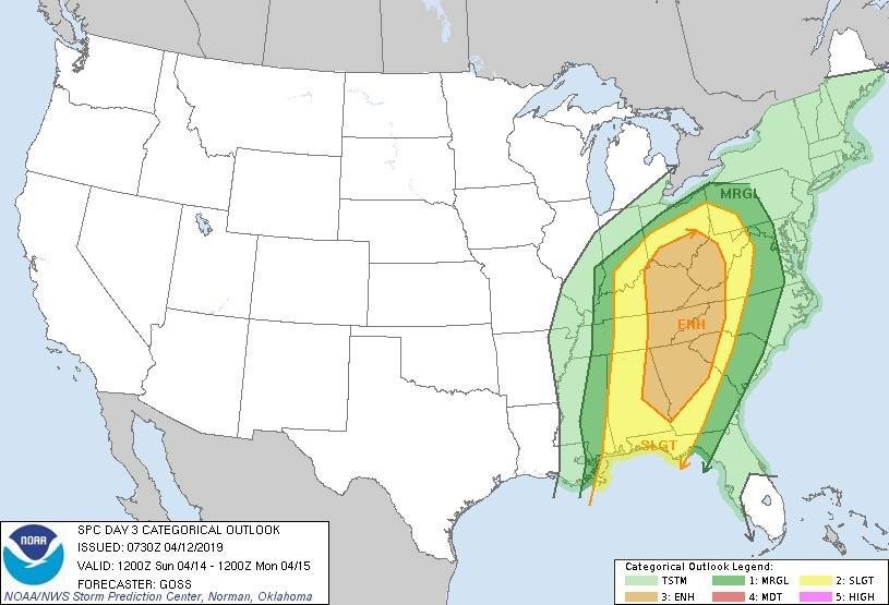
Well, much like I expected the enhanced area shifted east for tomorrow. I guess the question is how much destabilization occurs tomorrow. The tornado threat doesn't seem that high as of now, but I guess that is subject to change? A couple of you all mentioned the NAM as showing something pretty nasty. Today's threat across LA/MS looks downright ominous though. The ongoing question is, will that transpire east tomorrow?