

ouamber
-
Posts
647 -
Joined
-
Last visited
Content Type
Profiles
Blogs
Forums
American Weather
Media Demo
Store
Gallery
Posts posted by ouamber
-
-
1 hour ago, Weatherdemon said:
Buddy of mine just told me he was stuck in Sapulpa for several days after the GHD storm.
bring it!!!
We lived in Tulsa and had to walk a mile to the Walgreens for milk and bread! I lived in an apartment complex and my car was buried for two weeks! Good times! I ate so much snow ice cream!
-
 1
1
-
-
10 minutes ago, Weatherdemon said:
Thanks. I’ve never heard of ICON

No worries! I think it's one of the newer ones on tropical tidbits, but I know nothing about it, lol.
-
1
-
-
12 minutes ago, Weatherdemon said:
I don’t get lost very often but, what is the ICON and GHD storm?
ICON is a model, and Groundhog Day storm from 2011.
-
1
-
-
hmmmm..wondering how much the weekend storm can dig and how low is the HP above it going to be? 18Z ICON looks similar to the GHD storm of 2011.
-
1
-
-
Good luck to all you MO folks!! The excessive cold rain and days without a WSW here is Tulsa is over 1400 days now. It's an absolute joke! I see nothing on the horizon to get even remotely excited about. All this talk about "this will be the year to break the snow drought" LIES! (Yes, I'm pouting.... #SorryNotSorry #This"winter"sucks!
-
2
-
-
What a waste of all this water in January! Freezing rain blows!
-
 1
1
-
-
Here is the video from the 21 car pile up in Tulsa! Absolutely insane!! That I-244/I-44 fork split is always dangerous...even when it's dry!
-
Just watched the news say the City of Tulsa officials commenting that they weren't prepared for the storm! They said they didn't even start sand and salting the roads till after 7:30pm!

-
Spitting Sleet/freezing Rain on the SW side of Tulsa in between Sapulpa and Jenks.
-
1
-
-
I'm on the SW side of Tulsa, right on the Creek County/Tulsa County line....hoping it travels further NE! Wishing we could all cash in on this!

-
1
-
-
It's gonna come down to when this system kicks out. If it comes later on Friday, the cold air has retreated. We almost need it to be faster...and come Wednesday into Thursday.
-
If only we were 10 degrees colder today..this storm could've been real interesting! Cold Rain Sucks!
-
1 hour ago, StormChazer said:
So....do we owe the GFS an apology?
I personally will not be giving an apology. It still sucks!
-
1
-
-
For Fallin to declare a state of emergency for this is just about the biggest bust for Oklahoma!
-
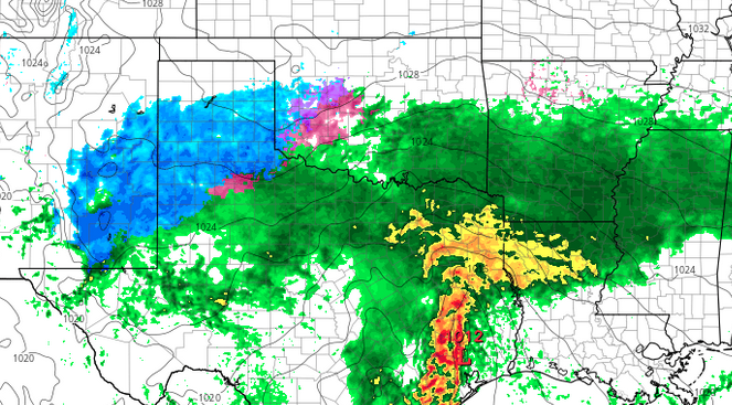
Hmmm....I see that. It does look similar.
I'm wishcasting for the low to close off, which would pull it back north and go negative tilt. Long shot, but that's what I'm hoping for.
-
1
-
-
18Z 3K NAM @ hour 39
-
Through hour 35, the 12K NAM has the low in the boot of Texas, but the 3K NAM has the low north of Houston. That's a HUGE difference!
-
1
-
-
Dangit...models are pretty depressing today!
-
Is it on shore yet to be sampled?
-
Does anyone get the UKMET?
-
Just now, OUGrad05 said:
You mean Mike Morgan?
Yes, that GUY! LOL
-
13 minutes ago, Weatherdemon said:
CH 9 in OKC has 4-8 inches from SW OK through NE OK. Width covers virtually all of NE OK. along with .25 of ice in the same area.
Where's Mike Morgan to get the hype train started? Channel 4 will no doubt have some high amounts! I live in Tulsa, but that guy is fun to watch when I'm in OKC!
-
So are we throwing out the NAM all together? I've been throwing the GFS out!
-
18Z NAM12k is doomsday for Oklahoma! Pretty much a foot+ for the state!? And at 84 it's ongoing!
-
1
-
MO/KS/AR/OK 2019-2020 Winter Wonderland Discussion
in Central/Western States
Posted
AFD TUL