
Jonbo
-
Posts
586 -
Joined
-
Last visited
Content Type
Profiles
Blogs
Forums
American Weather
Media Demo
Store
Gallery
Everything posted by Jonbo
-
Central/Western Medium-Long Range Discussion
Jonbo replied to andyhb's topic in Central/Western States
GFS going a bit bonkers.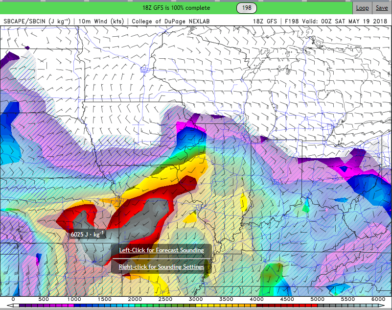
-
MO/KS/AR/OK 2019-2020 Winter Wonderland Discussion
Jonbo replied to JoMo's topic in Central/Western States
How about that Marginal severe weather risk for Monday? Winter won't take over without a fight i guess. -
Central/Western Medium-Long Range Discussion
Jonbo replied to andyhb's topic in Central/Western States
Outflow boundary set up in that area overnight so I can't be surprised it's taking off now. Some rotation also. -
Devastating tornado strikes Joplin, Missouri
Jonbo replied to Hoosier's topic in Weather Forecasting and Discussion
It makes me wonder (not to discredit the overall force of the tornado) that since it threw vehicles around like toys (among an overwhelming amount of the rest of what was in its path), that could have weakened them enough to "help" get them out. I'm not the expert but just speculation on my end. -
Devastating tornado strikes Joplin, Missouri
Jonbo replied to Hoosier's topic in Weather Forecasting and Discussion
JoMo, I really appreciate the updates and the new videos posted by you and others. I probably would never have seen them without these posts. Thank you -
Devastating tornado strikes Joplin, Missouri
Jonbo replied to Hoosier's topic in Weather Forecasting and Discussion
I liked the cafeteria one mostly because you could really scrutinize how the debris is reacting in relation to the winds due to the ceiling having collapsed. -
Devastating tornado strikes Joplin, Missouri
Jonbo replied to Hoosier's topic in Weather Forecasting and Discussion
Seeing that track on the map with EF ratings, it's just so baffling that it literally become a monster right as it hit Joplin then weakened (relative) as it exited the main part of the city. It's one of those once in a decade or maybe even century storms for such a pretty large city. -
Historic Tornado Outbreak April 27, 2011
Jonbo replied to CUmet's topic in Weather Forecasting and Discussion
So many of these tornadoes went through fairly populated cities and towns that I can't be too surprised if the death toll continues to climb. Stil sobering -
Historic Tornado Outbreak April 27, 2011
Jonbo replied to CUmet's topic in Weather Forecasting and Discussion
Picture reminds me of the Andover tornado -
Historic Tornado Outbreak April 27, 2011
Jonbo replied to CUmet's topic in Weather Forecasting and Discussion
Wall cloud on cam just north of Downtown Birmingham -
Historic Tornado Outbreak April 27, 2011
Jonbo replied to CUmet's topic in Weather Forecasting and Discussion
33/40 showing stream from another chaster (forgot the name) and it is absolutely huge. God I hope people in Birmingham take shelter in a very good structure -
Historic Tornado Outbreak April 27, 2011
Jonbo replied to CUmet's topic in Weather Forecasting and Discussion
Mayor confirmed at least 1 fatality likely related so far -
Historic Tornado Outbreak April 27, 2011
Jonbo replied to CUmet's topic in Weather Forecasting and Discussion
Holy sh*t is an understatement to what I'm watching on the 33/40 stream. -
Historic Tornado Outbreak April 27, 2011
Jonbo replied to CUmet's topic in Weather Forecasting and Discussion
Tornado gaining strength on the ABC 33/40 stream -
Historic Tornado Outbreak April 27, 2011
Jonbo replied to CUmet's topic in Weather Forecasting and Discussion
Checking the local news sites (and twitter), lots of large trees down and some structural damage so far reported.