CoolHandMike
-
Posts
1,561 -
Joined
-
Last visited
Content Type
Profiles
Blogs
Forums
American Weather
Media Demo
Store
Gallery
Posts posted by CoolHandMike
-
-

Dang. Haven't seen a hail signature like that in quite some time...
-
 2
2
-
-
Granted, I only have four years of data from current location, but this is the earliest we've been above 80. Peaked at 85.2°F.
-
6 minutes ago, Albedoman said:
oh its coming like i said earlier wam bam thank you mam. 2 inches - no way 1 inch remote possibility likely .60 in of rain. keep the spring flowers budding and green up some grass areas. No drought buster for sure. I am waiting for the comments of a 3-6+ in snow event in less than 10 days on both the GFS and CMC evening runs ---what a joke
man I stopped checking for digital snow on the GFS like a month ago. It's all fake news. Pretty to look at, and ponder at, but never real.
-
1
-
-
2 hours ago, LVLion77 said:
The nowcast is trending negative for getting much rain in eastern PA. Hope we see some development. We desperately need a solid 1”-2” rainfall.
I feel like nowcasting is the only way to see how things pan out these days. Forecasts have been utter rubbish for (checks notes...) years now? Yeesh. No disrespect to our prof mets, but yeah. Rain all afternoon today? Nope. Ten degrees lower than forecasted yesterday. Countless model-predicted snows this winter and nothing. Something is deeply amiss in our ability to forecast weather with any kind of accuracy these days.
I feel like all we can do at this point is watch the radar and try to see what's going to happen in the next couple of hours. Forget being able to see anything long-term, other than painting really, really broad strokes.
That said... I am somewhat concerned with the radar at the moment:

-
Temps now creeping up, we're at 52, woo hoo.
-
2 hours ago, BBasile said:
52F now vs. a forecast 59F. Big ol' bust. Hoping tomorrow's storms don't bust like today's temps.
Our high was 50.9 here, almost 10 degrees off the forecast. Can't win 'em all, I guess.
-
1
-
-
Ok, that'll do. Still coming down, too.

-
Still waiting for this to verify. Surely this will verify, right? I captured this about 10am this morning:

Current conditions:

-
And just like we all knew would happen, poof, gone. It was a pretty OK winter this year at least. I'm kinda on to scoping some spring t-storms now.
-
Wind advisory for Berks just went up. Good grief, I swear I don't remember it ever being as windy as it has been these past few years. It's kind of ridiculous. My wife and I were going to do a bunch of outdoor stuff today but we noped out when it started gusting above 20.
-
1
-
 1
1
-
-
32 minutes ago, Albedoman said:
First 3-6 inches of the soil is called the A- horizon which has had a temporary permafrost and will easily become muddy once the soils are above 36 degrees. That is what you are seeing now. If you dug down below 6 inches, the soils are still frozen with what little moisture we received from the New Years t storms. Once you get down below the B- Horizon 1-2 feet - it is dry as a bone. . Red Sky is right- we need significant long duration rain events of 3-5 inches over several weeks when the the B- horizon is not frozen. to put a dent in the drought. That usually does not happen until mid march, especially after an extremely cold winter that we had thus far. A week of 50-60 degree weather will aid in thawing out the soil profile, especially with rain showers or even fog.
By the way, we will most likely get another accumulating snow storm in the next two weeks based on my previous observations from the winter of 2020. Mr Raccoon wiped out my feeder last night of food. I sat there and watch him go to town. He knows there something brewing since that was the last time I saw him at my squirrel feeder. Beware of the ides of March LOL
My high IMBY was 47.8°F today, and 44 the day before. My top soil is dry AF. We're still super dry up here in Reading.
FWIW, we got near to an inch of liquid precip (snow melt+rain) last Sunday, and my basement sump started cycling almost as soon as the snow started melting. I would have thought that if the ground was deeply frozen that all of that would have run off, but our extremely localized groundwater flow has seemingly been forever altered by our massive flooding rains in July 2023, so who knows what is actually happening down there.
As much as I'd love one last, good snow storm, I agree, we still need rain and lots of it. Although, maybe not another flooding event. I think there are still some roads closed from that previous event I mentioned (due to bridges still being washed out).
-
12 minutes ago, Kevin Reilly said:
67 and sunny that day.
34 and snizzle to rain. Then blowing 20-30 the day after. At this point I'm just happy if it's cloudy out.
Maybe we should start a thread and just mercilessly mock this digital snowstorm until then. It'd at least give us something to do.
-
 1
1
-
-
Ok. So. Why was today's forecast so hilariously bad? It was supposed to get above 50, but we never even cracked 40. And now I see possible snow in the overnight? I guess the rain panned out, but still. Underpredicting the temp by ~10°F on the day is somewhat alarming.

-
33 minutes ago, RedSky said:
185,000 just in PA without power
~128k in Peco territory alone. Stay safe out there everyone!
-
Ok NOW it's getting gusty.
-
5 minutes ago, Kevin Reilly said:
See we just needed to get today’s wind machine out of the way!
Still waiting for it. Forecast said it would start at 4pm, but it's still pretty calm out there at 4:30.
-
Dang, it's pouring out there. We're up to .77" on the day, with a band of heavy rain still heading towards us. There's even been a few lightning strikes!
-
Got just over an inch of really fluffy stuff, now up to 31.6°F.

-
It just started sticking to the pavement up here. 30.5°F
-
Still snowing ever so lightly. What a delightful morning to be WFH, sipping coffee in my pj's and watching SnowTV™.
-
1
-
-
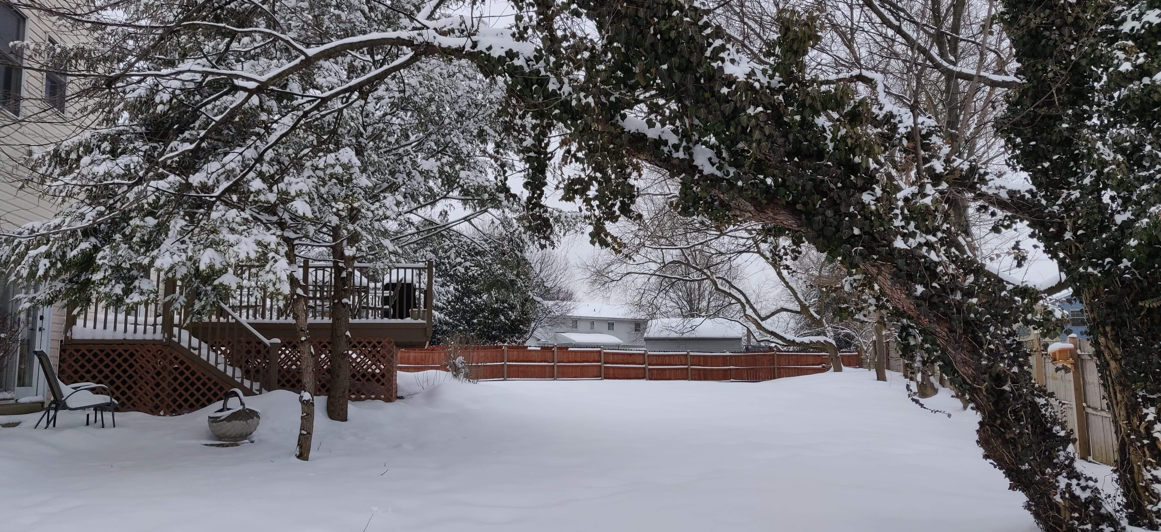
Maybe around a half an inch up here. Very pretty to wake up to.
-
2
-
-
Looks like we have a dusting up here, but it's still only flurries for us for now
-
6 minutes ago, penndotguy said:
30F not a flake to be found
yeah I've seen maybe one or two in the past couple of hours
-
1
-
-
My mom said snow in Oxford!
-
2
-
E PA/NJ/DE Spring 2025 Obs/Discussion
in Philadelphia Region
Posted
Dang. Haven't seen such a strong hail signature in a while. Radarscope reports 2" hail.