

Bubbler86
-
Posts
29,682 -
Joined
-
Last visited
Content Type
Profiles
Blogs
Forums
American Weather
Media Demo
Store
Gallery
Posts posted by Bubbler86
-
-
12 minutes ago, Blizzard of 93 said:
Exactly, thanks & snow maps are just showing model output. Just because a poster posts a map doesn’t necessarily mean that is their forecast or that it should be believed. We just show what an official weather model had for that particular run.
Also those of us that have been doing this for decades know that storms can show on the models, get “lost” for a day or 2 and then come back to original ideas sometimes.Maybe some people on here should find another board if they don’t like or understand how things work in this hobby or profession for some.
The snow maps do not bother me and on this board in particular they seem to be popular but if someone says they see folly in posting snow maps with no science behind them/explanation of why, then I cannot argue too much as they do have a valid point (though again I am not a fan of separate boards or moderation.) Many, many, many snow maps are posted for naught if you look at it after the fact. To me the Snow maps are the fun side of the board but not fun for everyone I guess.
-
 2
2
-
 2
2
-
-
14 minutes ago, mahantango#1 said:
That must have been bad on Peters Mountain this morning State Police were there like rescuing people that were stranded. Peters mountain as I keep saying is a dividing line on the weather between the Lower Susquehanna and the Middle Susquehanna.
![May be an image of map and text that says '8:14 Sun Feb 16 Enter your destination New Buffalo ד 98% Closure x Winter weather on PA 225 both directions between CLARKS VALLEY and PETERS MOUNTAIN MOUN RDRIVER lanes closed, closed.Intersection CLARKS VALLEY RD MIDDLE PAXTON [2TWP1- Intersection PETERS MOUNTAIN RDRIVER RD in HALIFAX [2TWP] Severity: ArcherySupply Archery Supply পাচনা Start Time: Unknown Anticipated End Time 2025 6:01 am Last Updated: Feb 16, 2025 at 08:30 AM Feb 16 2025 6:24 am Appalachian Trall O 225 3 nno. Quido Maps Lega 出 125 511)'](https://scontent-iad3-1.xx.fbcdn.net/v/t39.30808-6/480100511_9689717067719783_4330109182100556870_n.jpg?_nc_cat=110&ccb=1-7&_nc_sid=bd9a62&_nc_ohc=J2s6lzcdfsUQ7kNvgFZMP6W&_nc_oc=AdhCxogSXarZDfchUC63i76lrnnvNlq6b0fjepAKgnx908NDtDAszx6Rzwuk1BuXm8c&_nc_zt=23&_nc_ht=scontent-iad3-1.xx&_nc_gid=ArWgz670rdTCLkrxuBfNwCm&oh=00_AYDGPbUsbf9b8OGTKAt4L3EX20qb2LC9WAWaaX7d2VqAOA&oe=67B7B3CA)
We were looking in the 209 corridor. Quite the different world there.
-
1 minute ago, WmsptWx said:
It's almost as if we should relegate 100+ hour model discussion to a separate thread for wish casting.
How is having a meteorological discussion of why a model is doing something a wish cast? LOL. Now if you mean the snow maps, which I do sometimes too, then carry on.
-
2
-
-
Just now, mahantango#1 said:
Why?
The reason you just posted, high chance of winter weather issue that are not present anywhere else.
-
5 minutes ago, mahantango#1 said:
It was announced on abc27 this morning.
Do not go over Peters Mountain if you don't have too. It is a solid sheet of slush and ice. I am currently stranded at the top and cars are stuck everywhere. It is 618 Sunday morning
When we were looking for a place in 2018 we looked from Adamstown to Hometown to areas up 11/15 and eventually over here...and the number one thing my wife eventually found is she wanted nothing to do with coming into the Harrisburg area from the mountains to the north.
-
2 minutes ago, sauss06 said:
I’m hearing of power outages down south from the incoming wind
If we get 55-65 we can probably assume the worst here AND despite the drought, the ground is quite wet at the top layer right now for smaller/more shallow trees.
-
 1
1
-
-
1 minute ago, mitchnick said:
Responding to a post in the MA I said:
I'm sure you haven't looked at the 6z Nam very closely, but it simply parks the tpv over the Dakotas and appears to be all southern stream. Maybe that's a victory as well, to keep the tpv more or less stationary and let the southern vort pivot counterclockwise around it. Of course, the kicker might just wreck that option in future runs.
Yea, spot on. The easier way to win in my opinion. Less influence from the High/TPV and we have ourselves a Secs/Mecs Miller A. Otherwise, we need the "kicker" (AKA the N/S trough) to suck the storm back as it is going to go wide with that boundary in the Carolinas.
-
15 minutes ago, mitchnick said:
It's become entertaining how every model is jumping around like I have honestly not seen. Sorry to see the 6z Euro drop east some but Eps had a bigger jump se. It would be nice if the Nam with one of its classic NW jumps was correct.
In the end, this strikes me as the first big storm of the season when Sby got around a foot and I got 3".
I feel it has been a winter where the ridges have asserted themselves more than we want...and not talking the usual SER. More from the Northwest. I also feel like there have been two camps with this system so far, a classic Miller A which is wholly dependent on where the boundary is, and Miller B or hybrid type solutions. Too far out for the Meso's to show their hand on that though but if option one we need less of a push from the high and option b needs a possible collab from the N/S.
-
4 hours ago, Yardstickgozinya said:
High Wind Warning
URGENT - WEATHER MESSAGE
National Weather Service State College PA
312 AM EST Sun Feb 16 2025

PAZ006-011-012-019-026>028-035>037-041-042-045-046-049>053-056>059-
063>066-170400-
/O.UPG.KCTP.HW.A.0001.250216T1700Z-250217T1700Z/
/O.NEW.KCTP.HW.W.0001.250216T1800Z-250217T2100Z/
Potter-Cameron-Northern Clinton-Southern Centre-Huntingdon-
Mifflin-Juniata-Fulton-Franklin-Tioga-Northern Lycoming-Sullivan-
Southern Clinton-Southern Lycoming-Union-Snyder-Montour-
Northumberland-Columbia-Perry-Dauphin-Schuylkill-Lebanon-
Cumberland-Adams-York-Lancaster-
Including the cities of McConnellsburg, Huntingdon, Wellsboro,
Sunbury, Mount Union, Hershey, Lebanon, Renovo, State College,
Laporte, Williamsport, Lewisburg, Gettysburg, York, Trout Run,
Lancaster, Mansfield, Mifflintown, Shamokin, Bloomsburg,
Carlisle, Lock Haven, Newport, Harrisburg, Berwick, Danville,
Pottsville, Selinsgrove, Coudersport, Emporium, Chambersburg, and
Lewistown
312 AM EST Sun Feb 16 2025

...HIGH WIND WARNING IN EFFECT FROM 1 PM THIS AFTERNOON TO 4 PM EST
MONDAY...

* WHAT...West winds 20 to 30 mph with gusts 50 to 60 mph expected.

* WHERE...A portion of central Pennsylvania.

* WHEN...From 1 PM this afternoon to 4 PM EST Monday.

* IMPACTS...Damaging winds will blow down trees and power lines.
  Widespread power outages are expected. Travel will be difficult,
  especially for high profile vehicles.

* ADDITIONAL DETAILS...The strongest wind gusts are expected Sunday
  afternoon into Sunday evening. The strong winds will usher in much
  colder air, with temperatures in the 10s and 20s and wind chills
  ranging from the single digits below zero in northern PA to teens
  in southern PA.

PRECAUTIONARY/PREPAREDNESS ACTIONS...

Do not touch downed lines and report any power outages to your
electric company. Travel is highly discouraged due to slick roadways
and the possibility of downed trees and power lines.

Use extra caution when driving, especially if operating a high
profile vehicle. Secure outdoor objects.

Fasten loose objects or shelter objects in a safe location prior to
the onset of winds.
I worry that this may be a time that these warnings actually verify. We have had a string of events where the worst winds were with little or no highlighting.
-
1
-
-
The Nam is in great position to throw decent over running snows over a good portion of PA. 540 line is in VA not the Carolinas like it is on the rgem. The back stream reasons behind this are a fascinating discuss but seems people like the snow maps and final results more. The position of the high is a big reason for difference boundary positions.

-
Just opened one model so far this AM and it has hardly changed from yesterday 12Z except the precip field. It is a tiny bit S/E this AM which does make a difference but with all the different reasons being thrown around for when systems are or are not amping at certain locations, the Icon is a basic Miller A which turns the corner of the boundary tracks.
12Z Yesterday

6Z Today

-
Just now, Jns2183 said:
No blocking, no big jet dip
Sent from my SM-G970U1 using Tapatalk
We need something to pull if the confluence and 540 line is going to be so far south.
-
8 minutes ago, GrandmasterB said:
I like the look of the NAM at 84. Probably not worth a lot but notable nonetheless.
Like psu posted on the ma and the 540 comment here, the boundary is farther north which will lead to a much better starting position for a coastal along with waa snows. Still not my beloved Miller a though.
-
1
-
-
2 minutes ago, AccuChris said:
Cant hate this hour 84 on the NAM

.540 in VA is a lot better for us than the depicts with it in the Carolinas.
-
On the kicker discussion, which is also raging in the ma forum, what I do not get is what people would expect to happen if it was not there? I see the kicker/ns energy as the very thing that could capture this low (whether one believes if is forming on the wrong boundary or not.). I think the Gfs depiction seems quite clear in that it is forming energy on the boundary which is so very far south next week due to the advancing tpv. Without that NS wave I feel like whatever forms would be a fast moving wave that has little in the way of northward adjustment. This is for open convo, I could be totally wrong, but I have never heard the word kicker in these forums more than the last 24 hours. It seems to be a panacea to try and explain away bad model runs.
-
-
5 minutes ago, Itstrainingtime said:
Regarding models -
IF...and this is a huge IF...but if we end up getting shutout this week I WILL start giving some credence to the AI. It has consistently been SE all along.
Both of them.
-
1
-
-
12 minutes ago, Itstrainingtime said:
I grew up in the 70s. Outside of February 1978 it was a brutal decade. It would be carnage in here if that was repeated.
Back then we did not have "constant rumors" of the great pattern since our childhood. Sometimes the Interwebs take away some of the enjoyment. Growing up a 2-4" snow used to be fun and an event, now it is often a "what if'.
-
2
-
-
8 minutes ago, AccuChris said:
The latest from JB to add to the debate/discussion

.Thanks!
-
1
-
-
3 minutes ago, Blizzard of 93 said:
This is great info from @psuhoffman :
The high is to the NW not N or NE of the system which is less suppressive.
If you're referring to my comments about the analogs typically being a NW storm...I pointed out those setups didn't have the cold and high pressure to the extreme we have so it changes things. But those setups all ended up NW of progged at 100 hours. The true arctic boundary is through DC leading into the event. Yes there is cold well to our south but its not deep cold...the cold boundary down in the TN valley is shallower cold. We've got major snows well up into our area that started with a boundary there. But the key is for the wave associated with the arctic front to be the one that activates and amplifies NOT the one along the coastal front. That does not mean a cutter...the storm type I am thinking here with a somewhat similar h5 progression (DOES NOT MEAN THIS STORM GETS TO THE LEVEL OF THESE) is 1996, Feb 2006, March 2017. March 2017 is the best example of a TPV split where the storm rides up in between with a very similar H5 track of the upper low. What screwed us in that storm was the arctic boundary wave to our west amplified too much and held on way too long. I am NOT saying that should happen...but that the wave on that boundary should be the one with more focus not down over the SE so far disconnected from all the energy. Feb 2006 we had boudary issues but the 850 line was way down further south than it is here. That storm also had a wave on the arctic boundary that helped draw it up or it would have been way OTS had it focused on the coastal front. Same with 1996. If you amplify the wave a bit more along the arctic front that shallow cold south of the arctic boundary can be overcome really easy. Watch how fast that boundary can rocket NW if you amplify a wave along the boundary just a little. God knows we've seen that kill us 10000 times, why can't it help us once? When I look at the H5 track I don't see a suppressed look...usually the heaviest snow ends up close to the base of the H5 track northward and that is coming across out our latitude. It's rare to see a big snowstorm hit Richmond and Ocean City from a cut off H5 low that tracks through Ohio and PA. Find me a good example of that.
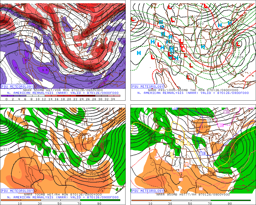
If the H5 looked like this...March 1980... I would be really worried.
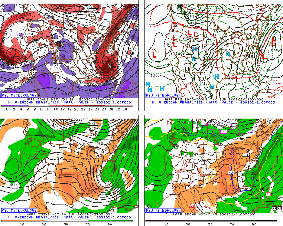
Some other storms that Jacked SE of DC, and all of these at least got 6" into the DC Baltimore area but the Jack was SE of 95...but look at the H5 and how suppressive it is or how far south in some cases a cut off
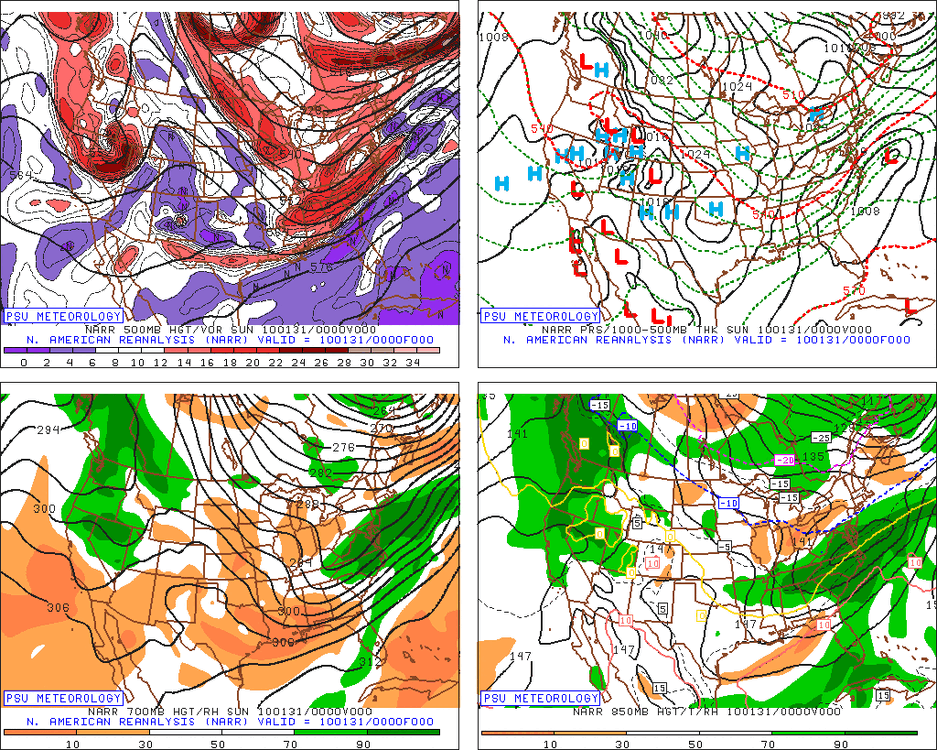
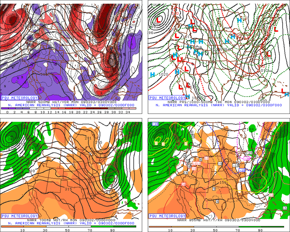
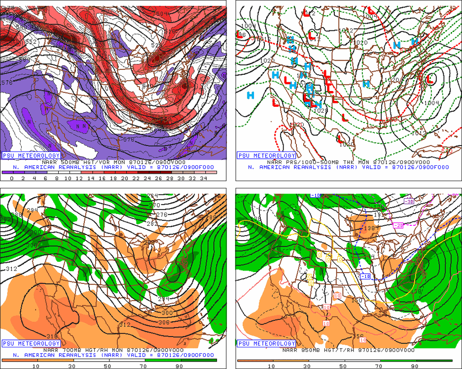
Now look at the H5 even on the GFS for our system and this is the most hostile h5 look of all the runs today...but one of these h5 does not look like all the others!
Ive been looking at SE misses, you know how I obsess over every thing that can go wrong, and I don't see any that look like this at H5. That doesn't mean I think a NW miss is likely...I think the colder regime here offsets a H5 look that without a crazy 1050 high WOULD be an issue for a possible NW track.
I could also see a SE miss if we had a really weak system. That isnt suppression its just a weak system not amplifying enough to gain latitude. I would be more worried about runs that don't show much snow anywhere and a 3-6" snow missing to our SE. That is very believable. But a storm amplified enough to cause a 12" snow somewhere with the H5 low that far to the NW and a flow that is not at all suppressive just sliding ENE and OTS, well its not the profile of our SE misses with 12" snows just to our SE.
That said...I guess there is a first time for everything... or maybe the models end up right but for the wrong reason and the wave trends to a disconnected weak POS and there is no 10" plus snows anywhere! That would be a more typical way to miss in this h5 setup. But I don't see a scenario where MO gets 16" of snow and a wave is approaching us from the TN/OH valley with that h5 look and suddenly it gets suppressed to our south. That doesn't add up to me.
I am not trying to be confrontational...I am always open to learning and I am wrong plenty so I am willing for anyone to show me where I am wrong here...I just don't see any comps to this. What I do see when I tried to find similar setups with a splitting TPV under a west based block where the western lobe splits and cuts off over the upper midwest are mostly storms that ended up if anything more amplified than we want, not less.
I personally agree with this assertion in why the GFS should have shown more precip back over and into the 500 low. And his other points are valid but that is not what the GFS did so there has to be a reason the shuttered the entire southern complex well into the ocean. I fear it was the influence from a stronger higher to the NW combined with a lagging NS.
-
1
-
-
1 minute ago, Blizzard of 93 said:
12z tomorrow we make a comeback
The winds are going to blow in some good model runs.
-
Just now, Itstrainingtime said:
When will the progression SE end?
Will it end?
When the TPV/High decides to allow it.
-
1
-
-
-
Just now, Itstrainingtime said:
In the words of Nike: "Just do it!"
Is that the same Nike Nico Harrison used to work for? I think Pelinka might have said that same phrase to Nico.
-
 1
1
-


Central PA Winter 2024/2025
in Upstate New York/Pennsylvania
Posted
Nam is similar through 45. Probably would not see what the boundary is going to be until hour 70+. On another note, it was 33 when I got up this AM. It is up to 43 now.