96blizz
-
Posts
2,530 -
Joined
-
Last visited
Content Type
Profiles
Blogs
Forums
American Weather
Media Demo
Store
Gallery
Everything posted by 96blizz
-
Back to Back Major Synoptic Snowstorms!
96blizz replied to BuffaloWeather's topic in Upstate New York/Pennsylvania
-
Back to Back Major Synoptic Snowstorms!
96blizz replied to BuffaloWeather's topic in Upstate New York/Pennsylvania
BGM is currently 6-9” (although their own maps don’t match that) so I can’t see them going that high. I see them going 8-12” with the CYA of “locally higher amounts” -
Back to Back Major Synoptic Snowstorms!
96blizz replied to BuffaloWeather's topic in Upstate New York/Pennsylvania
Sniff sniff... -
Back to Back Major Synoptic Snowstorms!
96blizz replied to BuffaloWeather's topic in Upstate New York/Pennsylvania
Full UKIE run. Looks good for storm 2 as well (all 10:1). -
Back to Back Major Synoptic Snowstorms!
96blizz replied to BuffaloWeather's topic in Upstate New York/Pennsylvania
Clearly but the NW extent of the snow tells me it’s no NAM! Need to see precip frames which I don’t have. -
Back to Back Major Synoptic Snowstorms!
96blizz replied to BuffaloWeather's topic in Upstate New York/Pennsylvania
UKIE certainly not buying any far NW solution -
Back to Back Major Synoptic Snowstorms!
96blizz replied to BuffaloWeather's topic in Upstate New York/Pennsylvania
The NAM had the whole I 95 crew freaking out with the big one only to correct itself and move towards consensus guidance the last day. It’s over amped bias should strongly be considered here as each subsequent model seems to be close to holding serve. -
Back to Back Major Synoptic Snowstorms!
96blizz replied to BuffaloWeather's topic in Upstate New York/Pennsylvania
We will take it, eh?
-
Back to Back Major Synoptic Snowstorms!
96blizz replied to BuffaloWeather's topic in Upstate New York/Pennsylvania
Being newer to the area, I really watched the models for the 2/2 to 2/3 storm and the RGEM did the best with lake enhancement. This is an encouraging run by the Canucks after our own Americans tried to drive people to their roofs for a swan dive. -
Back to Back Major Synoptic Snowstorms!
96blizz replied to BuffaloWeather's topic in Upstate New York/Pennsylvania
RGEM back off the ledge... -
Back to Back Major Synoptic Snowstorms!
96blizz replied to BuffaloWeather's topic in Upstate New York/Pennsylvania
The guidebook says these always tick back SE late after the NW ticks... -
Back to Back Major Synoptic Snowstorms!
96blizz replied to BuffaloWeather's topic in Upstate New York/Pennsylvania
Congrats! -
Back to Back Major Synoptic Snowstorms!
96blizz replied to BuffaloWeather's topic in Upstate New York/Pennsylvania
Well, for one, the most recent NAM is even further NW and warmer with major dry slot issues... -
Back to Back Major Synoptic Snowstorms!
96blizz replied to BuffaloWeather's topic in Upstate New York/Pennsylvania
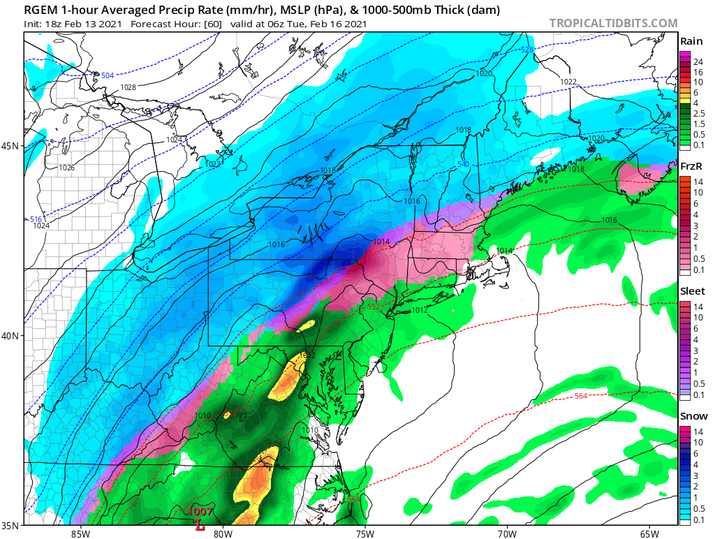
You really are paranoid! Drop the mesos till we are within 36. And the 18z GFS and RGEM (image) looked nothing like the 0z NAM!
-
Back to Back Major Synoptic Snowstorms!
96blizz replied to BuffaloWeather's topic in Upstate New York/Pennsylvania
The Monday event one of my favorite parts of this whole series. Because it didn’t phase with tonight’s “event” it made for a back to back snowfall with only a minor lull. Worked out perfectly for us! -
Back to Back Major Synoptic Snowstorms!
96blizz replied to BuffaloWeather's topic in Upstate New York/Pennsylvania
Of course. There’s a madness to my method. you do well and I’m likely to do okay buddy! We’re good. Gonna be a fun one! -
Back to Back Major Synoptic Snowstorms!
96blizz replied to BuffaloWeather's topic in Upstate New York/Pennsylvania
Rooting for you Matt! -
Back to Back Major Synoptic Snowstorms!
96blizz replied to BuffaloWeather's topic in Upstate New York/Pennsylvania
Growing up in Monmouth County NJ the prospects of a 12”+ snowstorm would have me insane with excitement. Up here? I’m like, “Cool. Cool.” You make your own opportunities in business and life. -
Growing up in Monmouth County NJ the prospects of a 12”+ snowstorm would have me insane with excitement. Up here? I’m like, “Cool. Cool.” You make your own opportunities in business and life!
-
Would love one for both since they’re so close together. Will make model watching more fun.
-
At the end of the day, the difference between 10” and 14” is... 4”.
-
I can’t see 20:1 happening...
-
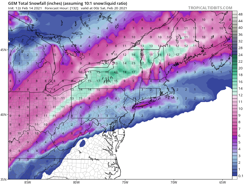
Two storm total at 10:1. Toss ‘em.
-
Smellin’ the taint on the 2nd storm. Nice.
-
The collective model consistency is impressive. Excited - especially having my two young boys home for the week!