

96blizz
-
Posts
2,530 -
Joined
-
Last visited
Content Type
Profiles
Blogs
Forums
American Weather
Media Demo
Store
Gallery
Posts posted by 96blizz
-
-
1 minute ago, wolfie09 said:
If we could just speed the front up a touch lol Still time..
.thumb.png.0d4459bb4334c7b8b92c2da3597a7010.png)
Lot of moisture pumping along that front. Could be nice. Could suck. Lol
-
 2
2
-
 1
1
-
-
Just now, wolfie09 said:
Nice man, I remember you telling me you grew up in Monmouth..I used to walk the Henry Hudson trail in that area..In-laws live in freehold but I grew up in Jackson and Staten island..
My parents were from Great Kills in Staten Island. I played golf in high school and college and love Metedeconk in Jackson. Good stuff!
-
1
-
-
13 minutes ago, wolfie09 said:
In-laws down in Monmouth county NJ have a blizzard warning.. Not an all timer but solid event, at least for there...
BLIZZARD WARNING IN EFFECT FROM 7 PM THIS EVENING TO 7 PM EST
SATURDAY...

* WHAT...Blizzard conditions expected. Total snow accumulations of
  8 to 15 inches. Winds gusting as high as 50 mph.

* WHERE...The coastal counties of New Jersey, and coastal sections
  of Sussex County in Delaware.

* WHEN...From 7 PM this evening to 7 PM EST Saturday.

* IMPACTS...Travel could be very difficult to impossible. Areas
  of blowing snow could significantly reduce visibility. Gusty
  winds could bring down tree branches.

* ADDITIONAL DETAILS...Snow is expected to begin on Friday
  evening, with snow becoming heavy after midnight. The most
  likely time for blizzard conditions is late Friday night through
  midday Saturday. Blizzard conditions are primarily expected at
  or within a few miles from the coast. Snow will wind down
  Saturday afternoon.
Where I grew up and my Dad is still there in my childhood home in Belford NJ.
-
1
-
-
My boys enjoying this mornings snow.

-
9
-
-
1 minute ago, crossbowftw3 said:
Interesting trends overnight for the coastal, but probably game over for me seeing >6”
still, sneaking a nice advisory event would be fine even if it gets massively dwarfed by whatever maximums there are on LI and due east from there
The 6z euro shifted west again. After March 2017 you keep watching coastals all the way to the finish line.
-
We are not far away from a nice event
-
7 minutes ago, LakeEffectKing said:
Pattern is too progressive...this is the coast's storm....
Don’t piss in my Cheerios!
(yeah, you’re probably right).
-
6 hours ago, BGM Blizzard said:
Honestly it's getting close to that time where it becomes too far fetched for this to come west enough for i81 to get anything decent. Time to start hoping it east ots? There'd be some epic NE melts.
Lol. Bad Karma won’t help us!
It’s still 81 hours out. Nothing is impossible at this juncture. I had my heart ripped out of my chest too may times growing up down there!
-
1
-
-
5 minutes ago, wolfie09 said:
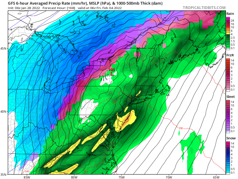
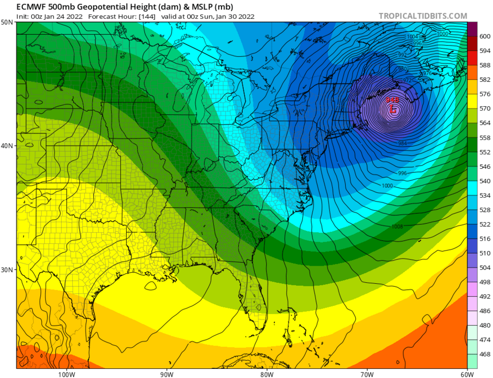
As the upper level trough becomes negatively tilted late Friday
night into Saturday, an upper level low will develop over the Mid
Atlantic, which will eventually kick the deepening low northeast off
the east coast and into New England. This in turn will support a
strong nor`easter off the coast of the Carolina`s to track northeast
along the East Coast throughout Saturday, and track east of Maine
Saturday night. Model consensus continues to keep the track of the
low, well to the east of the region and therefore expect only the
western fringes of the low to drop some snow across the far eastern
boarder of the region Saturday afternoon. Otherwise, expect the
remainder of the forecast area to remain on the dry side with all
but a small chance for some light lake effect snow southeast of Lake
Ontario Saturday morning due to limited synoptic moisture and
northwest flow.

Then, conditions look to be mainly quiet through the second half of
the weekend and into the first couple of days of the new work week
as surface high pressure will span across the region. However, the
upper level trough aloft will remain intact across the Mid-Atlantic
and Northeast which will not only keep the cold air in place but
also provide for some chances for a few snow showers Sunday night as
the trough axis passes overhead.
I dunno. This seems rather “absolute” this far out but they are the pros!
-
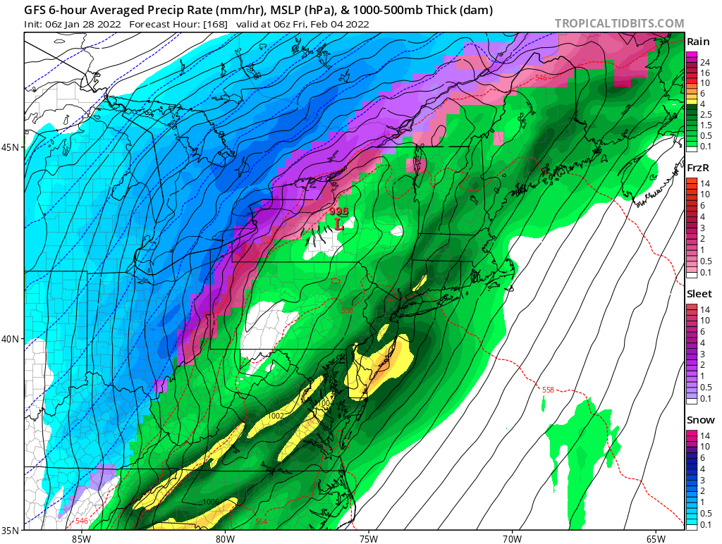
Long range NAM at 18z.
Long way to go…
-
 2
2
-
-
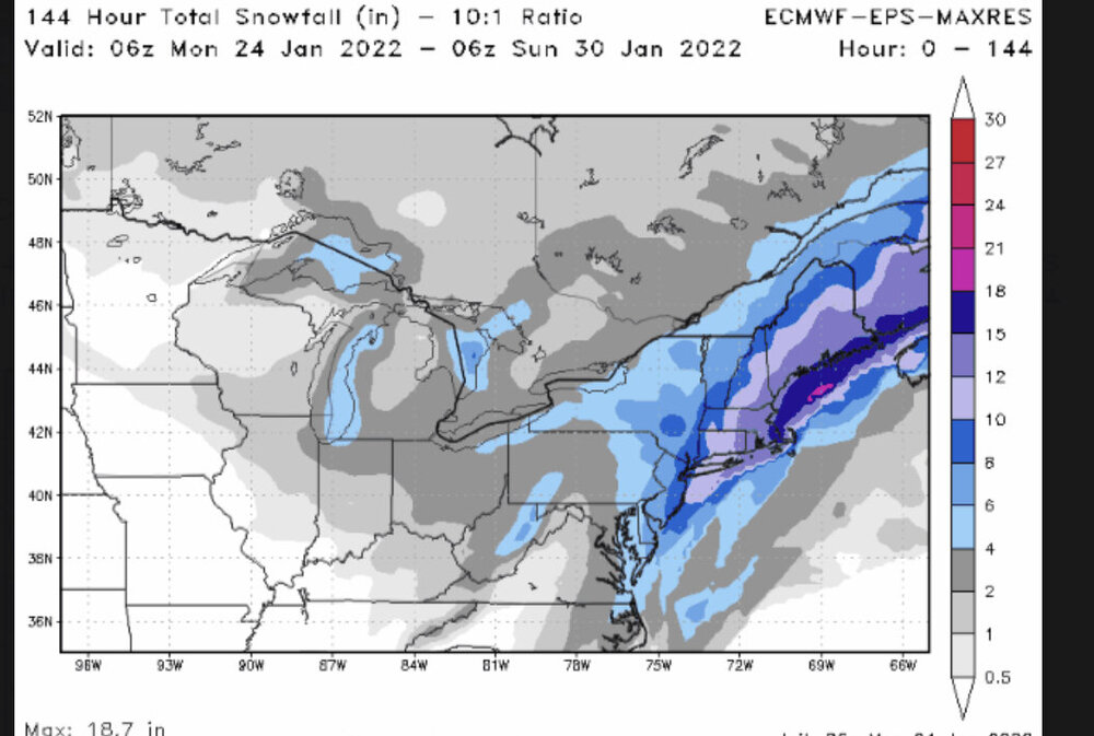
15 minutes ago, Ericjcrash said:
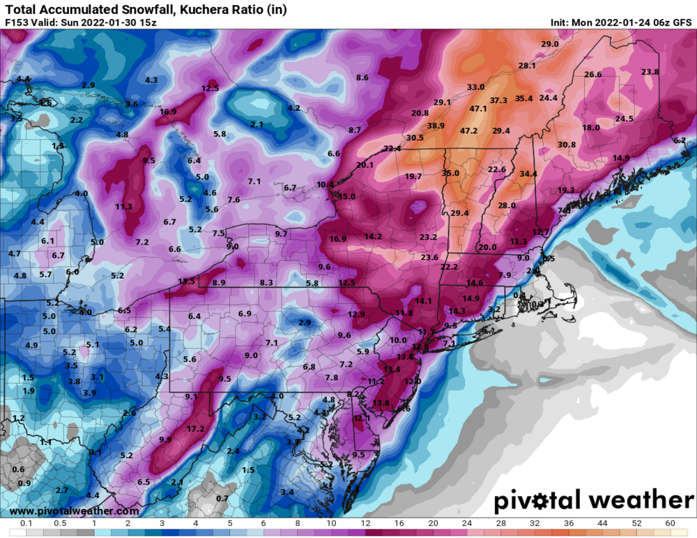
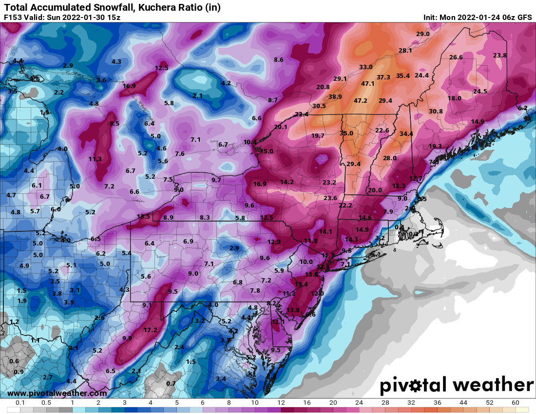
Anyone have a weenie Euro control run Kutchera clown? 10
Sure. For sh*ts and giggles
edit sorry that’s 10:1 but you get the idea

-
7 minutes ago, rochesterdave said:
I know it’s a pipe dream and I am keeping it in context but this is still 100 hrs out. There are several pieces of energy involved. I don’t think you can COMPLETELY rule out a scenario where this comes west 100-200 miles. Certainly CNY is still in the realm of possibilities. Same as a complete OTS miss is possible.
Like Matt said, CLE didn’t think they had a chance in hell….Thursday 12z would be when the models start being really accurate. But they do seem to be locked in with a Boston Special as of now. I’ll still be watching. Of course. LolI grew up and spent 37 years in NJ.
TRUST ME. It’s possible.
-
4
-
1
-
-
6 minutes ago, Ericjcrash said:
Euro is less amped. That's a wrap here and maybe for a Queens trip too. Need west and need it now lol.
Huh.
-
Just now, BuffaloWeather said:
GFS with a 3 footer for Boston

The Patriots still got waxed.
-
2
-
2
-
-
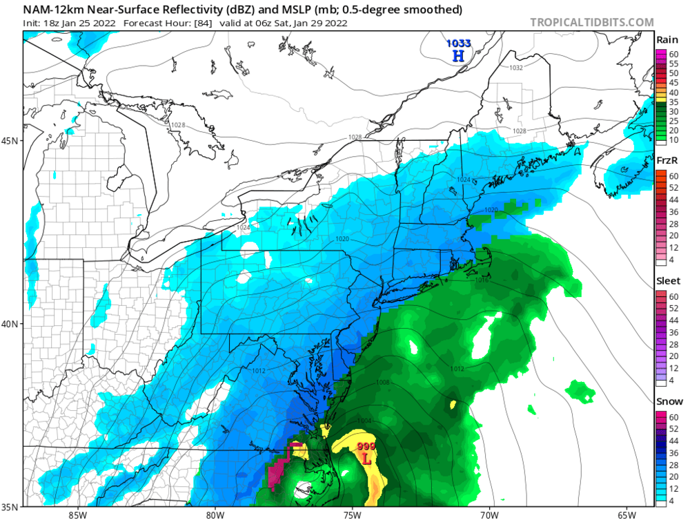
53 minutes ago, tim123 said:
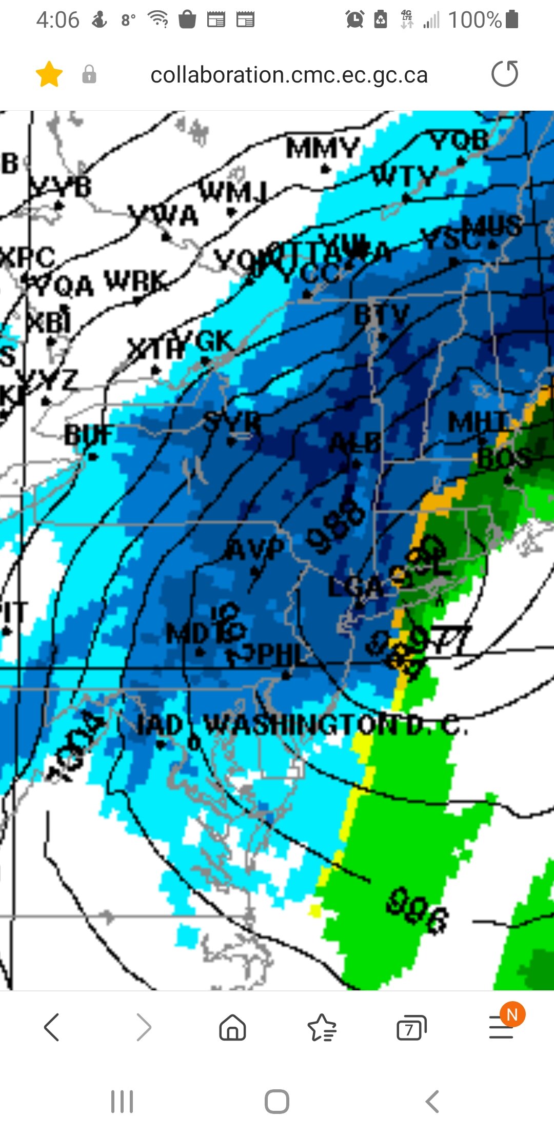
Is this 18z CMC to hour 120?? Do you have a link?
-
7 minutes ago, tim123 said:
I mean don't look like a monster but long duration lake enhanced.
And still a ton of time left.
-
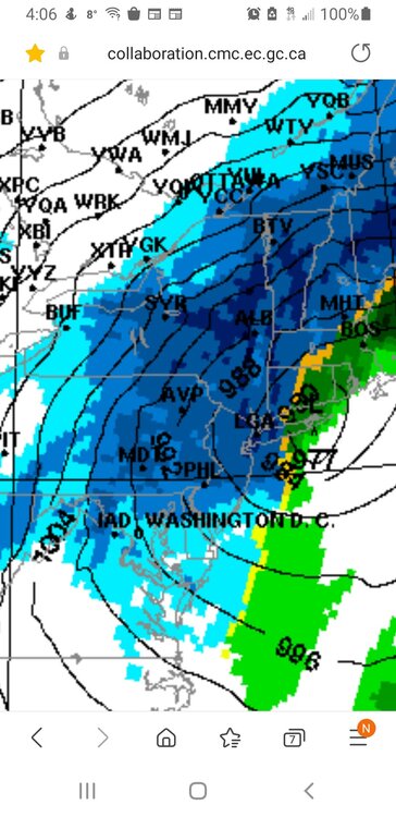
CMC gets us.
let’s go!!!
-
Just now, Ericjcrash said:
Pretty hard not to get excited with this potential. Might not be the snowiest winter here yet but the constant cold and as if 8 days ago solid snowpack have been nice. Now the clippers are adding to the fun.
Yesterday was gorgeous. Snow all day and night and the most insane day of football ever.
My deepest condolences Bills fans. Nobody deserved to lose that one.
Sincerely,
A perpetually losing Dolphins fan
-
3
-
-
1 minute ago, rochesterdave said:

Leeeeeaaaaaaan left!!
-
1
-
-
6 minutes ago, tim123 said:
Pic?
-
2
-
-
6z EPS is JACKED!!!! Not there for us yet but we aren’t out of this!
-
1
-
-
9 minutes ago, LakeEffectKing said:

We chase!!!!
-
Because why not?
-
1
-
-
.png.e57730fc68c5d44f9d6003e4fbcada40.png)


Upstate/Eastern New York-Pattern Change Vs Tughill Curse?
in Upstate New York/Pennsylvania
Posted
I lived this pain for so long. Hence, my Guidelines.
There’s always one final gut punch.