

Natester
-
Posts
1,221 -
Joined
-
Last visited
Content Type
Profiles
Blogs
Forums
American Weather
Media Demo
Store
Gallery
Posts posted by Natester
-
-
Calling it, CR only gets 3-4 inches of snow from this while IC gets 5-6 inches. Chicago doesn't get much either due to the drying. At least we had the December 29, 2020 dumping of 8 inches here.
-
 1
1
-
-
40 minutes ago, mimillman said:
Sadly our 6 year double digit drought continues
Speaking of that, it's been 11 years since we had a 10"+ inch storm.
-
 1
1
-
-
I don't see CR getting 6 inches from this storm. I'd say we'd get 4-5 inches from this.
-
 1
1
-
-
Spoke too soon, light snow here now. Likely won't get much from this though.
-
No precip at here whatsoever. The edge of the snow shield stopped just SE of Cedar Rapids. Not complaining since we got over 8 inches on Tuesday.
In other news, no substantial power outages in Iowa even though the ZR got pretty far north (up to Johnson county).
-
DVN update:
AREA FORECAST DISCUSSION
NATIONAL WEATHER SERVICE QUAD CITIES IA IL
1227 PM CST FRI JAN 1 2021
UPDATE
ISSUED AT 1227 PM CST FRI JAN 1 2021
VERY TRICKY SITUATION WITH THIS FORECAST. MODEL ICE NUCLEATION HAD
SUGGESTED MORE ICE IN THE COLUMN, AND THIS MORNING MANY OF THE
AWOS SITES REPORTED SNOW WHEN IT WAS ACTUALLY FZRA. AS ADDITIONAL
GROUND TRUTH CAME IN IT WAS EVIDENT THAT EVEN THOUGH THE FORECAST
WAS COLDER THAN PREVIOUS DAYS, THE EXISTENCE OF ICE WAS NOT THERE.
AS A RESULT ICE TOTALS INCREASED IN THE ADVISORY AND WARNING
AREAS. REPORTS OF WARNING CRITERIA ICE IN THE WARNING HAVE BEEN
RECEIVED AND UP TO .15 IN THE ADVISORY AREA. RADAR DATA NOW
SUGGESTS THE WARM LAYER IS COLLAPSING AND SNOW IS BEGINNING TO
TRANSITION THROUGH THE AREA. THE SNOW BAND HAS SETUP FURTHER NW
AND AS A RESULT HAD TO ADD COUNTIES TO ADVISORY. -
DMX radar is down due to a communications error, so there is no way of telling if it's snowing in southern Iowa anymore. Going to be a close call here. It's all snow in NW Missouri, though.
-
From LSX:
AREA FORECAST DISCUSSION...UPDATED
NATIONAL WEATHER SERVICE SAINT LOUIS MO
823 PM CST THU DEC 31 2020

UPDATE

ISSUED AT 804 PM CST THU DEC 31 2020

A BAND OF WINTRY PRECIPITATION HAS MOVED NORTH INTO SOUTHEAST
MISSOURI AND THE FAR SOUTHERN REACHES OF THE CWA AHEAD OF THE
PREVIOUS FORECAST. THIS BAND IS EXPECTED TO MAKE IT TO THE ST.
LOUIS METRO/COLUMBIA METRO REGION AROUND 04Z. WHILE THE LEADING
EDGE OF THIS PRECIPITATION COULD START AS SNOW OR A WINTRY MIX, IT
IS ANTICIPATED TO QUICKLY TRANSITION TO FREEZING RAIN. FREEZING
RAIN HAS BEEN REPORTED IN FARMINGTON, MO WITH THIS FIRST BAND.

A BRIEF BREAK IN PRECIPITATION IS POSSIBLE AFTER THIS FIRST SHOT
OF WINTRY MIX/FREEZING RAIN, HOWEVER THE GAP IN REFLECTIVITY HAS
BEEN FILLING IN OVER THE PAST HOUR. I CANNOT RULE OUT LIGHT
PRECIPITATION FALLING IN THE GAP BETWEEN THE FIRST ROUND OF
PRECIPITATION AND THE SECOND, MORE ROBUST ROUND OVERNIGHT.

MRM
In other words, it's moving an hour ahead of schedule.
-
7 minutes ago, WeatherMonger said:
NAM comes in less bullish yet still alarming. I'll take all the ice they can give if the power stays on.

Yikes! Significant shift north. Wouldn't be surprised if the edge of the precip shield clips us. At least winds won't be strong here.
EDIT: Nevermind. Previous NAM run has the precip shield clip us too.
-
ILX going for an Ice Storm warning for their NW CWA according to the point forecast matrix.
-
1
-
-
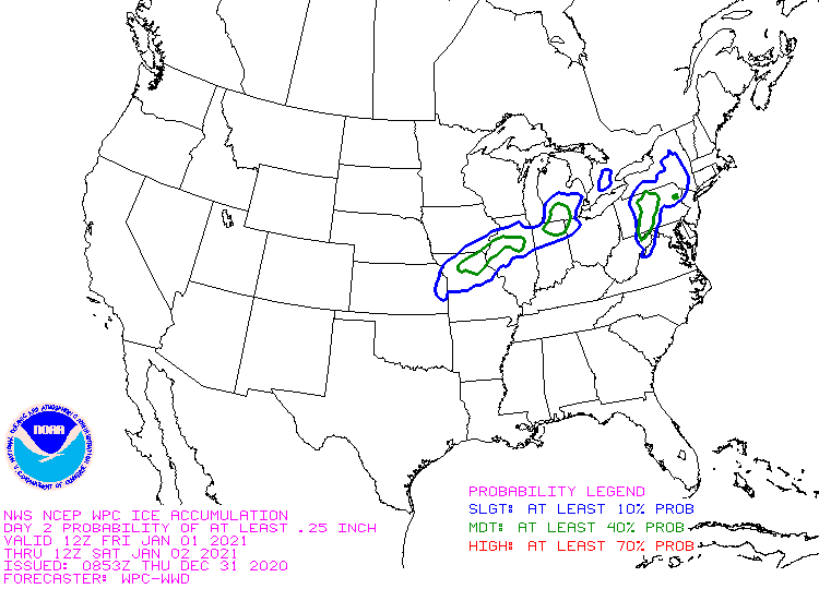
Just now, WeatherMonger said:
New WPC Ice Accrual map

Wouldn't be surprised to see substantial power outages in Missouri and Illinois tomorrow, especially with the wind gusts forecast to be at or over 35 mph.
-
Just now, ILSNOW said:
15Z RAP
Ice
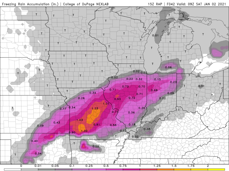
Snow
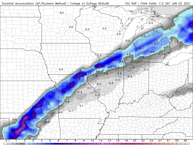
Major ice storm for SW Missouri if that verifies.
-
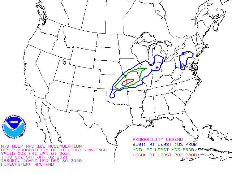
Day 2 ice map by WPC:
-
1
-
-
10 minutes ago, CoachLB said:
2 bad you gotta pay to play lol.
Yeah, you'd have to shell out 7 dollars a month to get those kind of maps. The best products on pivotal weather aren't free.
-
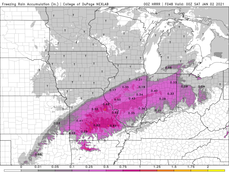
0z HRRR freezing rain accumulation map at hour 48.
-
Major SE shift in the 0z HRRR. Keeps the ZR out of Iowa entirely.
-
2
-
-
7 minutes ago, bl5585 said:
It seems like this is okay to share based on Pivotal Weather's terms.
Here is the latest RGEM with FRAM instead of QPF that was mentioned above.
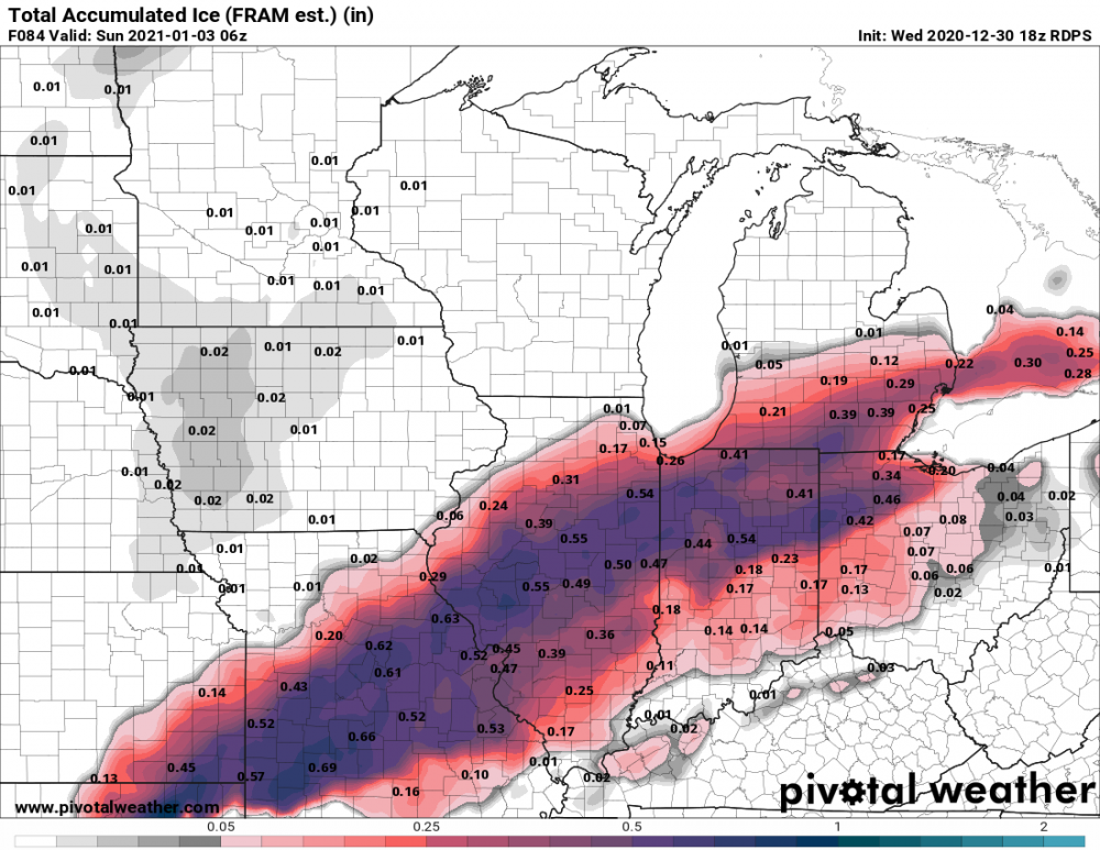
That spells borderline major ice storm for a lot of places if that verifies.
-
1
-
-
2 minutes ago, Hoosier said:
Regarding the freezing rain, something I am noticing on the guidance is that a portion of the higher precip rates happen while temps are around 28-30 degrees. Obviously that would make a difference in how much accretes as you can get away with some heavier rates at those temps.
That is a verbatim read of the models though, so if it ends up more like 31-32 during that time, then more will run off.
Wait, does heavy freezing rain run off at 28F? I thought it was 31-32F that it runs off in heavy rates.
-
Yep, it's official. All the models have trended southeast, including the GFS.
-
2
-
-
WPC Ice map for Friday.
-
1
-
-
Right on cue, 18z NAM (both 12k and 3k) trended southeast where the precip shield only skirts us.
-
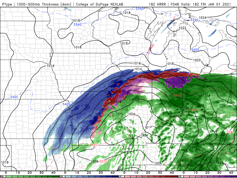
18z HRRR at hour 48. HRRR really ramps up the evaporative cooling. Not sure if that's actually realistic since all the other models have a much bigger zone of freezing rain.
-
The chance of siggy ice here is decreasing although siggy ice would be really bad here because:
1. gusty winds of 35 mph2. weakened and damaged trees from the derecho over 4.5 months ago.
If we do get any siggy ice, I doubt the power outages will be as long lasting as from the derecho.
-
12z NAM 12k came in slower, has the freezing rain arriving in Cedar Rapids after noon on Friday.

Jan 24-26th Potential Something Part 2
in Lakes/Ohio Valley
Posted
Realistically those totals should be slashed in half, no way that'll verify.