
TJay
-
Posts
796 -
Joined
-
Last visited
Content Type
Profiles
Blogs
Forums
American Weather
Media Demo
Store
Gallery
Posts posted by TJay
-
-
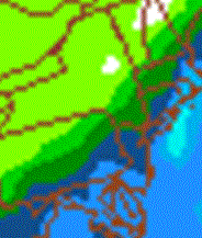
I saw some interesting images for us in other threads from the HRRR. I'm not famailr with this model but I did find it and ran some loops, tonight could get interesting if this model has a clue.
I cant even get it to display right
 I never used it either,
 -
And in the past 20 minutes I've seen numbers 4, 5, and 6 and they brought their friends too, very light snow has commenced in Goshen, probably won't last long though.

This one isn't for us,. Its backed off a lot here in Rockland, light snow now. Temps seem to be around 32, most of what came down this moring is quickly melting away
-
For the lower valley

MESOSCALE DISCUSSION 0048
NWS STORM PREDICTION CENTER NORMAN OK
1012 AM CST WED JAN 26 2011
AREAS AFFECTED...NERN NJ/NYC METRO AREA AND LONG ISLAND/SRN AND ERN
CT/RI
CONCERNING...WINTER MIXED PRECIPITATION
VALID 261612Z - 262015Z
ONGOING SNOWFALL WITH EMBEDDED AREAS OF HIGHER RATES FROM NERN NJ
THROUGH NEW YORK CITY METRO AREA...ACROSS LONG ISLAND TO SRN EXTENT
OF CT WILL PERSIST THROUGH 18Z. SNOWFALL RATES /UP TO 1 IN PER HR/
WILL SPREAD NEWD ACROSS ERN CT INTO RI THROUGH EARLY AFTERNOON.
MEANWHILE...THE NEW YORK CITY AREA SWWD INTO NERN/CENTRAL NJ MAY
TRANSITION TO A BRIEF 1-2 HOUR PERIOD OF SLEET AND/OR FREEZING RAIN
MIXED WITH LIGHT SNOW BEFORE PRECIPITATION DIMINISHES DURING THE
EARLY-MID AFTERNOON.
AT 1545Z...REGIONAL RADAR IMAGERY SHOWED A BAND OF WINTRY
PRECIPITATION...MAINLY IN THE FORM OF SNOW...EXTENDING FROM BWI/PHL
NEWD TO NYC AREA INTO SWRN NEW ENGLAND. ENELY SURFACE WINDS ACROSS
THIS REGION ARE EXPECTED TO MAINTAIN SUB-FREEZING TEMPERATURES.
FORECAST SOUNDINGS SUGGEST AN INCREASE IN LOWER TROPOSPHERIC
TEMPERATURES TO ABOVE 0 C IN THE 750-850 MB LAYER FROM CENTRAL NJ TO
THE NYC AREA...RESULTING IN VERTICAL THERMAL STRUCTURE SUPPORTIVE OF
A TRANSITION TO SOME SLEET/FREEZING RAIN MIXED WITH LIGHT SNOW BY
17-18Z. THESE THERMODYNAMIC TRENDS ARE SUPPORTED BY THE RUC AND 09Z
SREF.
FARTHER NE ACROSS SRN NEW ENGLAND...FORECAST SOUNDINGS SUGGEST THE
VERTICAL THERMAL PROFILE WILL REMAIN COLD ENOUGH FOR ALL SNOW
THROUGH MID AFTERNOON /20Z/...AND THEN A POTENTIAL FOR SLEET AND/OR
FREEZING RAIN MIXING IN WITH THE SNOW.
..PETERS.. 01/26/2011
-
NYZ067-068-270515-
/O.CON.KOKX.WW.Y.0005.000000T0000Z-110127T1100Z/
ORANGE-PUTNAM-
1112 AM EST WED JAN 26 2011
...WINTER WEATHER ADVISORY REMAINS IN EFFECT UNTIL 6 AM EST THURSDAY...
A WINTER WEATHER ADVISORY REMAINS IN EFFECT UNTIL 6 AM EST THURSDAY.
* LOCATIONS...ORANGE AND PUTNAM COUNTIES.
* HAZARDS...SNOW.
* ACCUMULATIONS...4 TO 8 INCHES...HIGHEST ACROSS EASTERN PUTNAM.
* TIMING...LIGHT TO MODERATE SNOW THROUGH EARLY AFTERNOON. LIGHT
WINTRY MIX OF SNOW AND FREEZING RAIN DURING MID TO LATE

AFTERNOON. MODERATE SNOW LATE TODAY INTO TONIGHT.
* IMPACTS...TRAVEL EXPECTED TO BE HAZARDOUS DURING THE EVENING
COMMUTE AND THURSDAY MORNING COMMUTE...WITH THE HEAVIEST SNOW
LIKELY FALLING THIS EVENING INTO THE OVERNIGHT TONIGHT.
-
The sun was poking out here in Goshen as well but I did count 3 snowflakes about 45 minutes ago
wow big difference from when I left,The clouds were socked in good
-
12Z NAM has the triple low that it showed last night, I guess its having feedback issues. Upton threw out last nights 0z NAM

-
I can see the sun here!!! lol
Back home it looked like it was ready to snow, the air was so moist my Pilot was covered in "dew" @19F. The only reason it didn't freeze is its covered in salt
-
Light snow changing to heavy snow with huge flakes within two minutes with 2/10 tenths of a mile visibility on I87 from Suffern on east in Rockland. Roads are covered. So much for this thing starting late afternoon/evening.
-
 This is what happens when a 1000 \'s of
  hit NCEP at the same time
The NAM says not much snow for us
weird run. SREF looks pretty good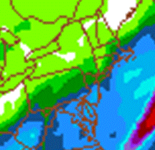
-
JB on Accuweather:
" U.S. MODELS ABOUT 50 TO 75 TOO FAR EAST Looking at the JMA and Euro has me confident in the ideas,
JB plays the JMA card

I never thought highly of it but someone mentioned in the NYC thread last night that within 72 hours its very good. Who knows if thats correct but we'll see shortly.
]MODEL DIAGNOSTIC DISCUSSION
NWS HYDROMETEOROLOGICAL PREDICTION CENTER CAMP SPRINGS MD
140 PM EST TUE JAN 25 2011
VALID JAN 25/1200 UTC THRU JAN 29/0000 UTC
...SEE NOUS42 KWNO ADMNFD FOR THE STATUS OF THE UPPER AIR
INGEST...
12Z FINAL MODEL PREFERENCES
ANY INITIALIZATION ERRORS WITH THE NAM AND GFS DO NOT APPEAR TO
SIGNIFICANTLY IMPACT THEIR SOLUTIONS.
...LOW PRESSURE SYSTEM LIFTING UP THE ATLANTIC COAST DAYS 1 AND
2...
PREFERENCE: GEM GLOBAL OR UKMET
THE NAM AND GFS TRACK THIS CYCLONE EAST OF THE ECMWF...WHICH POPS
THE CONSOLIDATED SURFACE LOW RIGHT ON THE DELMARVA SHORE 00Z/27
THURSDAY. THE GEM GLOBAL AND UKMET FORCE THE LOW JUST OFF THE
SOUTHERN DELMARVA PENINSULA BY THE START OF DAY 2...WHICH FITS
CLIMATOLOGY THE BEST FOR THE SYNOPTIC PATTERN WHICH HAS FINALLY
SETTLED OUT AFTER DAYS OF DISPARATE MODEL SOLUTIONS.
-
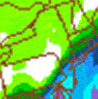
Euro QPF Map from the Philly Thread, not to shabby depending on where you're located
-
I would say about 3" here.. Anxiously awaiting the Euro... i am feeling FRINGED!!! lol

We still have a shot, we are real close to cashing in. Dr No in a few minutes....
-
Don't look good for us being on the wrong side of the fringe zone for big snow, lets see what the euro says.
12ZNAM
Total QPF
12Z GFS
Total QPF
-
Just got back from driving to KSWF to drop a friend off for a flight... What a disaster an unexpected 2 inches can have on the roads - A few spin-outs on I84.
~2 inches here and still snowing light to moderate.
Considering we may get shafted with the best stuff to our south tomorrow, I will take it!
Yes, it took me two hours to get in, really ridicules delays on Rt17 because of 2 to 3 inches of snow and messy unattended to road
-
That was interesting, they don't expect warnings even here, huh....,
Yes I certainly didn't expect to read that but we should know by lunchtime
-
WEDNESDAY`S STORM. LATEST SREF...GFS...GEFS AND ECMWF USED FOR THE
FORECAST. ALL MODELS TAKE LOW THAT IS FORMING OFF THE TEXAS COAST
AND TRACK IT TO NEAR THE NORTH CAROLINA COAST ON WEDNESDAY. THE
LOW THEN TRACKS NORTHEAST TO OVER THE 40N 70W BENCHMARK WEDNESDAY
NIGHT. ECMWF IS THE SLOWEST OF THE MODEL GUIDANCE IN TERMS OF
TIMING...BUT APPEARS TO FOLLOW A SIMILAR TRACK.
CONCERNS ABOUT MODEL GUIDANCE ARE HIGH DUE TO EXTENSIVE CONVECTIVE
PCPN BEING GENERATED THROUGH MODEL PARAMETRIZATION. THE LATENT HEAT
RELEASE AND THE DYNAMIC BUILDING OF THE DOWN STREAM RIDGE ARE
AFFECTED. THUS...WHILE MODEL TRACK IS CLUSTERED NICELY...HUMAN
UNCERTAINTY REMAINS HIGH FOR THE ACTUAL TRACK. THE NAM IS AN
INTERESTING EXAMPLE...AND WHILE BEING DISCARDED FOR FORECAST
INTEGRATION...IT IS RIGHT OF THE ENSEMBLED TRACK AND PRODUCES ZERO
QPF.
HAVE CONTINUED BASICALLY THE PREVIOUS FORECAST UNTIL THINGS BECOME
CLEAR. NOTE THAT NOAA WINTER RECONNAISSANCE IS BEING FLOWN FOR THIS
SYSTEM IN THE GULF OVERNIGHT. THESE CRITICAL OBSERVATIONS WILL GET
INCLUDED INTO TOMORROW`S 12Z AND SUBSEQUENT MODEL CYCLES. THUS
EXPECT THINGS TO BECOME CLEARER TOMORROW. NO WATCHES WILL BE ISSUED
THIS AFTERNOON AS WERE STILL OVER 48 HOURS FROM POSSIBLE WARNING
CRITERIA.
PTYPE IS A MAJOR ISSUE WITH THIS EVENT AS MODEL SOUNDINGS SUPPORT A
WARM NOSE ALOFT. EVEN INLAND LOCATIONS SHOULD EXPECT AT LEAST SOME
MIXED PCPN. A WINTRY MIX APPEARS TO BE THE PREDOMINATE TYPE WITH MORE
RAIN TO THE EAST. OF COURSE WITH TRACK AND QPF AMOUNT HIGHLY
UNCERTAIN...ANY SNOW AMOUNT FORECAST IS EVEN MORE UNCERTAIN. IT DOES
APPEAR THAT LIKELIHOOD OF WARNING CRITERIA SNOW IS LOW...EVEN
INLAND.
WINDS. LOW END WIND ADVISORY CRITERIA (G 40 KT) APPEARS POSSIBLE
WEDNESDAY EVENING FOR EASTERN SESSION (LONG ISLAND AND SE CT).
LASTLY FLOODING...THERE IS CURRENTLY 2 TO 3 INCHES OF WATER
EQUIVALENT WATER IT THE SNOW COVER. WITH POTENTIAL 1 TO 2 INCHES
LIQUID EQUIVALENT ADDED ON TO THIS FOR EASTERN SESSIONS (LONG ISLAND
AND SE CT)...PONDING/URBAN/BASEMENT FLOODING ARE A CONCERN. IN
ADDITION...THE WEIGHT OF THE SNOW ON FLAT ROOF STRUCTURES IS
SIGNIFICANT.
TIMING FOR PCPN ONSET IS MOST LIKELY MID TO LATE MORNING IN THE
SOUTHERN PORTION INCLUDING NYC AND LONG ISLAND ON WEDNESDAY. IT
LOOKS LIKE THE RUSH HOURS SHOULD BE DRY.
ENDING IS LATE WEDNESDAY NIGHT WITH JUST SOME LEFT OVER LIGHT SN
ON THURSDAY AM.
&&
-
Do you guys have Mike Buono (formerly of The Weather Channel) doing forecasts for the HV region of YNN? Here on the Capital District YNN he is the chief met. I'm wondering if all of their wx stuff comes out of one central location such as the Albany studios now.
FWIW ...low was -14F up at my house. Cold, but a bit dissapointing since we were already at -13 around 3 AM. I thought we were good for a run at -20 around dawn. Hey if it's gonna be way below zero you might as well go for the coldest. :

I believe I have seen him on air. YNN has so many on air mets it easy to confuse them
 I "think" I read when TWC rolled it out in April of this year here that the on air studio was going to be in Albany until they finshed building one in the TWC Hudson Valley main facility in Middletown (Wallkill).It think it still comes out of Albany on air with local reporters.
 I think they messed up the weather forecast last night with Albany's. They called for air temps to be from -15 to -25 this morning
-
Definitely going to be a cold one in the morning. Keep an ear out to the radio's-could be issues with some school district's who's buses don't have them plugged in for the weekend. I know the district I drove for, mechanics came in as early as 4:30 to get 200+ buses going-some need help big time when it's below 0º. Hope this is the only cold snap like this for the winter-snow I can deal with. Waiting out for a school bus in below 0º weather just stinks.
Any calls yet about this up coming storm for this area-or are the models still not in agreement of a big storm?
On YNN news this morning they listed two HV districts, one had a delay and the other canceled classes.
-
13 here @ 6PM, currently 12F. I haven't gotten below 1F this winter, tonight might be the night.
down to -3 this am.
-
Temp. at 16.1 as of 6pm. Forcast low of -10 for tonite on the east side of the county,-15 on the west side.

13 here @ 6PM, currently 12F. I haven't gotten below 1F this winter, tonight might be the night.
-
MODEL DIAGNOSTIC DISCUSSION
NWS HYDROMETEOROLOGICAL PREDICTION CENTER CAMP SPRINGS MD
135 PM EST SUN JAN 23 2011
VALID JAN 23/1200 UTC THRU JAN 27/0000 UTC
...SEE NOUS42 KWNO ADMNFD FOR THE STATUS OF THE UPPER AIR
INGEST...
12Z MODEL EVALUATION INCLUDING THE ECMWF AND FINAL PREFERENCES
...LOW PRESSURE MOVING ALONG THE US/CANADIAN BORDER THROUGH
TUESDAY...
PREFERENCE: NAM OR ECMWF
THE NAM AND ECMWF ARE VERY CLOSE REGARDING TRACK AND DEPTH OF THE
LOW THROUGH THE PERIOD...WHILE THE GFS...WHICH PRODUCED A FAST AND
DEEP OUTLIER SOLUTION...HAS TRENDED WEAKER/SLOWER...BUT STILL
APPEARS TO BE PLAYING CATCH-UP WITH OTHER GUIDANCE. THUS...ITS
SOLUTION IS IGNORED. WITH SUPPORT FROM THE NEW UKMET/GEM
REGIONAL...RECOMMEND EITHER THE NAM OR ECMWF.
...LOW PRESSURE MOVING FROM THE GULF OF MEXICO TO THE SOUTHEAST
COAST MON-WED...
PREFERENCE: MIDWAY BETWEEN UKMET/ECMWF...WITH NAM CLOSE AT 78-84
HRS
THE LOW TRACK...AND LIKELY STRENGTH DIFFERENCES AS WELL...APPEAR
DIRECTLY RELATED TO BOTH NORTHERN AND UPSTREAM DIFFERENCES. THE
GFS IS WEAKER AND LIES ALONG THE SOUTHERN/SOUTHEASTERN EDGE OF THE
12Z GUIDANCE ENVELOPE...WHICH IS ATTRIBUTED TO ITS FASTER/DEEPER
SOLUTION ALONG THE CANADIAN BORDER. TO ITS CREDIT...THE GFS HAS
TRENDED TOWARD A MORE PREFERRED SOLUTION WITH THE NORTHERN STREAM
BUT STILL APPEARS TO BE PLAYING CATCH UP. MEANWHILE...THE NAM HAS
INITIALIZATION PROBLEMS OVER THE PACIFIC...WHICH ARE BELIEVED TO
CONTRIBUTE TO ITS SLOWER/WEAKER SOLUTION ACROSS THE WEST...AND
ULTIMATELY...TO A LOW TRACK WHICH IS DEEPER AND JUST NORTH OF THE
GFS. THUS...ITS SOLUTION IS NOT PREFERRED. FINALLY...THE NEW ECMWF
HAS TRENDED WEAKER/SLOWER AND TOWARD THE PREFERRED CLUSTER OF
SOLUTIONS ACROSS THE WEST WHICH ACCOUNTS FOR ITS SLOWER LOW TRACK
THROUGH THE SOUTHEAST. THE NEW ECMWF ALSO SHOWS GOOD AGREEMENT
WITH THE PREFERRED CLUSTER OF SOLUTIONS WITH THE NORTHERN STREAM
ALONG THE CANADIAN BORDER. THUS...ITS SOLUTION APPEARS EQUALLY
PLAUSIBLE AS THE UKMET WHICH WAS THE PRELIMINARY PREFERENCE. TO
ADDRESS THE CONTINUED SOLUTION SPREAD AND ACCOMPANYING POTENTIAL
ERRORS IN INITIAL CONDITIONS...RECOMMEND AN INTERMEDIATE
POSITION/INFLUENCES FROM THE UKMET/ECMWF.
IN TERMS OF NCEP GUIDANCE...THE NAM'S POSITION AT 78-84 APPEARS
QUITE GOOD...BUT IS OTHERWISE CONSIDERED TOO FAR SOUTH AND NOT
SUFFICIENTLY STRONG WITH A SECONDARY LOW NEAR THE
APPALACHIANS...WHILE THE 09Z SREF MEAN IS NOT RECOMMENDED AT ANY
POINT SINCE THE NAM/GFS PARENT MEMBERS FROM THE 00-06Z CYCLE WERE
NOT PREFERRED.
-
Low of 1 this moring.
-
I need to make time to watch the concerts but the documentary on Darkness was very good. It's amazing how many songs he wrote for that album to only use a select few, which is why there is this "new" stuff. Also, you can finally buy the album or songs from the 25th Anniversary of the Rock and Roll Hall of Fame concert from 2009. I had a bootleg of that from the night that Bruce and the E Street Band were the house band but couldn't get anything from the first night when U2 filled that roll so I was glad to see this available. So I got all of the Bruce, U2, and Metallica stuff but there's plenty others that were involved. A heads up that if you try to get it from iTunes Jungleland is available only with the album only but if you get it from Amazon you can get it as a single along with everything else. It's all worth checking out.
Back on topic, the winds have been steadily increasing here, lots of snow blowing off the rooftops.
The documentary was very good, seen it on HBO. Its interesting to see how he used to create the songs, the quality of his music is refleted in that effort. The 25th Anniversary R&R concert DVD's are fantastic. Thanks for the MP3 tip.
I noticed the wind picking up on my way in after clearing the driveway. I was getting blown around a bit.
Next weeks storm looks like its going to be fun watching it get nailed down on guidance.
-
3.5" here. You mean the new Darkness box set that includes The Promise?? yes.
3.8 here. I need to pick that up, How are the DVD video's?
The Hudson Valley Thread
in Upstate New York/Pennsylvania
Posted
I'd say a few inches