

Tony Sisk
-
Posts
306 -
Joined
-
Last visited
Content Type
Profiles
Blogs
Forums
American Weather
Media Demo
Store
Gallery
Posts posted by Tony Sisk
-
-
Spaghetti here as well! It’s a great entree for snow!
-
 1
1
-
-
53 minutes ago, burrel2 said:
Clown show at nws_GSP. They've had Clemson go from 4-6 to 2-4 to Trace to 2-3 and now 1-2.
The whole time models have supported 2-4 inches and honestly they have not wavered at all, and if anything I would say they support more like 3-5 forecast at this point.
I'm starting to think there are some guys working there that like to forecast snow, and other guys who come in for a new shift that love to slash totals... wash, rinse, repeat. lol
There really is no other explanation. I’m stunned
-
2
-
-
9 minutes ago, burrel2 said:
Hrrr is straight porn for the Upstate and NE Georgia. Complete jackpot paste job... It's becoming clear that this area is going to get hammered for at least a few hours tonight before any changeover to sleet happens. I think 2-4 is a conservative call at this point, (I -85 north in SC and Gainesville, GA and points North and East in Georgia).
GSP has totally removed any snow accumulations in most of our area. To the point that I’m not sure why they still have a winter storm warning and not an ice warning. Their forecast has me shaking my head.
-
17 minutes ago, Tigerchick224 said:
Travelers Rest 41/27.
Just saw some snow on radar up at Caesar’s Head. Headed up to check it out and see if it’s verga or the real deal.
.Radar looks pretty good for sassafras to Caesar’s Head. Not bad for the early stuff.
-
1
-
-
1 hour ago, Tigerchick224 said:
That’s literally right up the 85 corridor, per usual.
.Genius that they built that interstate there.
-
1
-
 5
5
-
-
1 hour ago, calculus1 said:
Here's GSP's latest expected snowfall map. Numbers going down for NW piedmont but remaining quite strong in mountain areas:
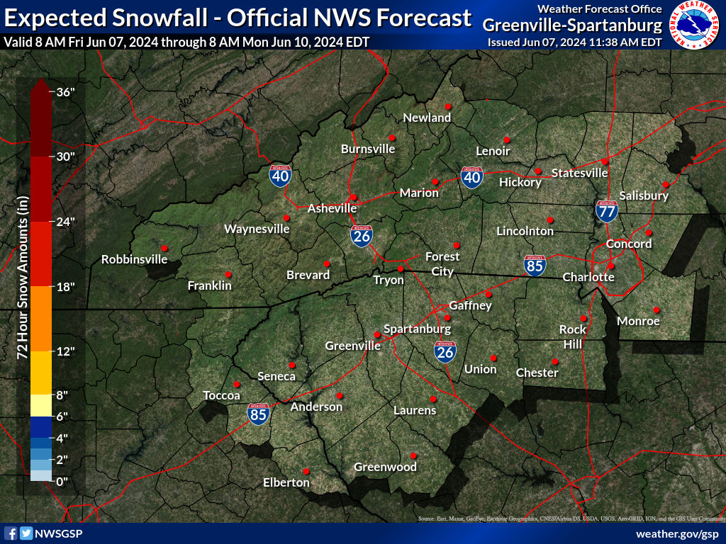
Pretty big shift downwards.
-
15 minutes ago, burrel2 said:
Euro is just an absolute crush job for north east Georgia and the northwestern upstate,sc.
for newbies in the state....sometimes this is broadly defined. You may be referring to Oconee and Pickens Counties. I think you are referring to the mountains. But most break the "upstate" using I-85. The upstate lower counties are McCormick, Greenwood, Laurens, Union. I'd love the entire upstate get clobbered. But I'm still thinking the sweet spot in SC will be along and above Hwy 11, but north of 85 should be very happy.
-
1 hour ago, Bevo said:
The light, lavender-ish band on that map (3"-6" Snow/Sleet) could stand to come south to where it would meet the top of the "M" in my opinion, but other than that it looks pretty damn solid.
I always have to remember that most of this board doesn't live in the Frozone like me. Lyman is in the Narnia of SE winterland (NW SC). We tend to benefit more than a lot of people with these storms. This helps me understand the overwhelming number of frustrated posts for literally every winter storm thread. I get it - it makes sense.
the middle of the "M" would be nice. The bottom of the "M" would be awesome!
-
The 2020's have given folks across the United States one rare weather event after another. We have seen things happen that have never happened before. With a name like Izzy, I have a feeling this storm is telling all the others to "hold my beer".
-
1
-
-
13 minutes ago, lilj4425 said:
Warm air advection killed the mojo.
I think 50%+ of the posts in this thread are from you.
-
 1
1
-
-
15 minutes ago, kvegas-wx said:
This will not age well. Are they using models from 2 days ago or what??
This is from the official GSP NWS
-
34 minutes ago, Local Yokel Wx said:
Several friends are running up 215 to hike and ride out the storm along the southern portion of the Great Balsams.
This will likely be the spot for the highest totals in our area
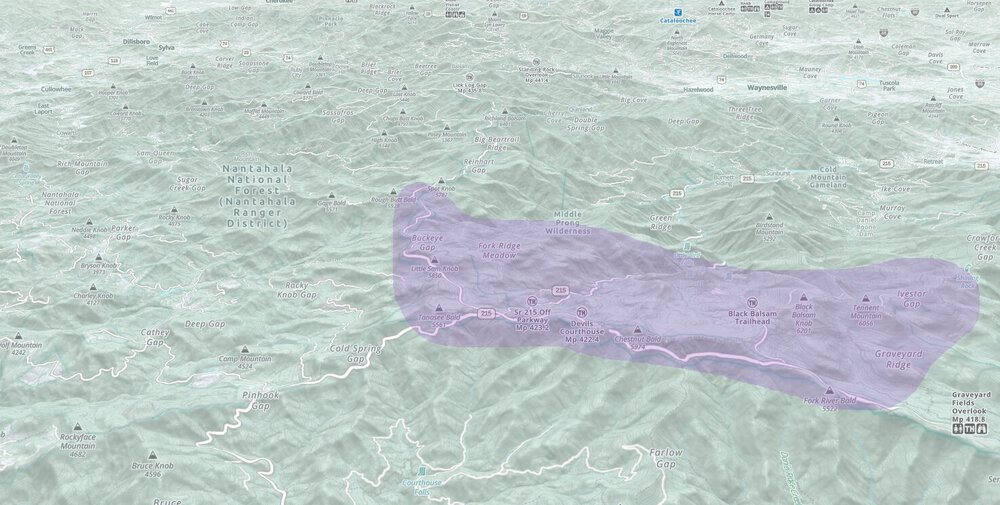
This may be borderline banter. Spent a NYE there camping. There was a foot of snow, the temp never got above 20. But it was sunny. We were sledding on the Blue Ridge Parkway. One of the most memorable experiences with my boys.
-
1
-
-
1 minute ago, Tigerchick224 said:
Upstate SC Peeps- Can I have some honest feedback on this first call map? I have a lot of friends and family who ask me about weather and I don’t want to disappoint them by being to bullish. I thought Chris Justus was somewhat conservative and heavily reliant on climo today,and with some of his past calls, within good reason. However, I am really liking this front end thump models are depicting before the warm nose. I tried to make a map between model ensemble estimates and his forecast. Thanks in advance!
.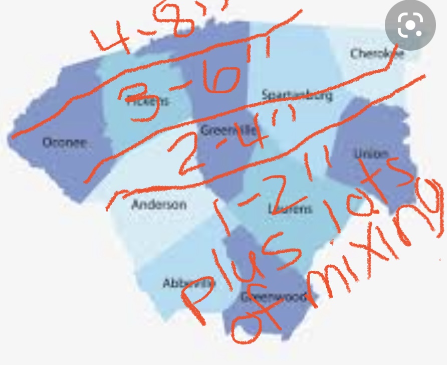
Tigerchick, that's pretty much what I'm going with. I have 5-8", 4-6" 2-3" and 1-2"...pretty much your same zones. I thought Chris put out an excellent videocast. There is still much uncertainty. And if we get the amount of ice that is potential, it will for sure cut down on the snow totals.
-
1
-
-
33 minutes ago, BretWx said:
Is GSP going to go with a blizzard watch??

 (Joke!)
we are hoping...not kidding!
-
1
-
-
1 hour ago, wncsnow said:
He is simply not as plugged in as many mets like Chris Justus he is my local favorite. No models are showing rain. Temps will be mid 20s...
Chris is really becoming a favorite. Hope he retires in Greenville…we got a good one!
-
3
-
-
5 minutes ago, BooneWX said:
I mean. There’s a reason why GSP didn’t cliff dive like this thread.
GSP has a consistent track record of being among the best in the business. No doubt about that.
-
1
-
 2
2
-
-
9 minutes ago, Snow dog said:
Yep. I'm in the current sweet spot, but i have full confidence we will not see the numbers these models are spitting out. 3-4" would be a great snow here in the upstate. Most models do a very poor job of predicting actual amounts..
I've lived here for 58 years and a weather geek since grade school. Upper Level Lows that drop from the plains typically do not pan out for the upstate. Those mountains can be our friend, and sometimes our enemy. The upper level low has to drop deep enough south and west, to get the energy needed from the gulf. When it happens, it becomes a 20 year snowstorm. But those ingredients need to be a perfect storm for that. I would caution to the 1-3 inch for the time being. Which is always a thrill in the upstate. But hoping for a repeat of Jan 1987 and Jan 1988!
-
3
-
1
-
-
The line is literally I-85, craziest thing ever
-
Snow Bunnie Chris Justice usually goes overboard with the forecasting. He low balled this one for sure. Roads are covered in all of the upstate! Dropping quarters at a strong rate. Surprised we haven’t heard thunder.
-
1
-
-
Snowing fatties in Taylors SC (East of Greenville)
-
57 minutes ago, WinstonSalemArlington said:
Katie, bar the door!

20% chance of heavy snow, that includes the blue ridge and smokies.
-
54 minutes ago, oconeexman said:
Enjoy it NC folks..post pics so us SC can at least see it.
Fortunately for us...a 30 minute drive and we can see a foot of snow!
-
1
-
-
43 minutes ago, mackerel_sky said:
Always! I’ve seen numerous times TR has 4-5” on the ground and I’ve got rain! December’18 , perfect example
Happened to me. Furman was in the football playoffs. Jeav6 snow started falling...was a near blizzard at times. 6” fell during the game. Cherrydale is less than 2 miles from Furman, same elevation. Not even a trace.
-
1
-
-
Just as I predicted. Temps have hit 36 in Greenville (near Haywood Mall) and it is snowing.
Jan 15-16 Winter Storm
in Southeastern States
Posted
Their weekend staff has been all over the place. I’m with you, they are consistently the best…but really confusing.