DFWWeather
-
Posts
468 -
Joined
-
Last visited
Content Type
Profiles
Blogs
Forums
American Weather
Media Demo
Store
Gallery
Everything posted by DFWWeather
-
Texas/Oklahoma Discussion & Obs Thread 2022
DFWWeather replied to It's Always Sunny's topic in Central/Western States
Today's operational runs of the GFS, ECMWF, CMC really backed off on the cold into Texas next week (not hadling the low level cold air into the Southern Plains, nor accounting for cold air damming). Actually, doing some crazy stuff. However, the ensembles still have a severe cold snap into Texas. The 18z op GFS starting to catch back on to the Texas intrusion. Interesting to note, a couple of ensembles members of the ECMWF and GEFS have DFW at 3 below zero for a low on Christmas. Don't think it will be that cold, but singles digits to I20 even in DFW, teens below zero in the panhandle and freezes to LRGV all very possible with this. Don't think it lasts longer than 3 to 5 days max. -
Texas/Oklahoma Discussion & Obs Thread 2022
DFWWeather replied to It's Always Sunny's topic in Central/Western States
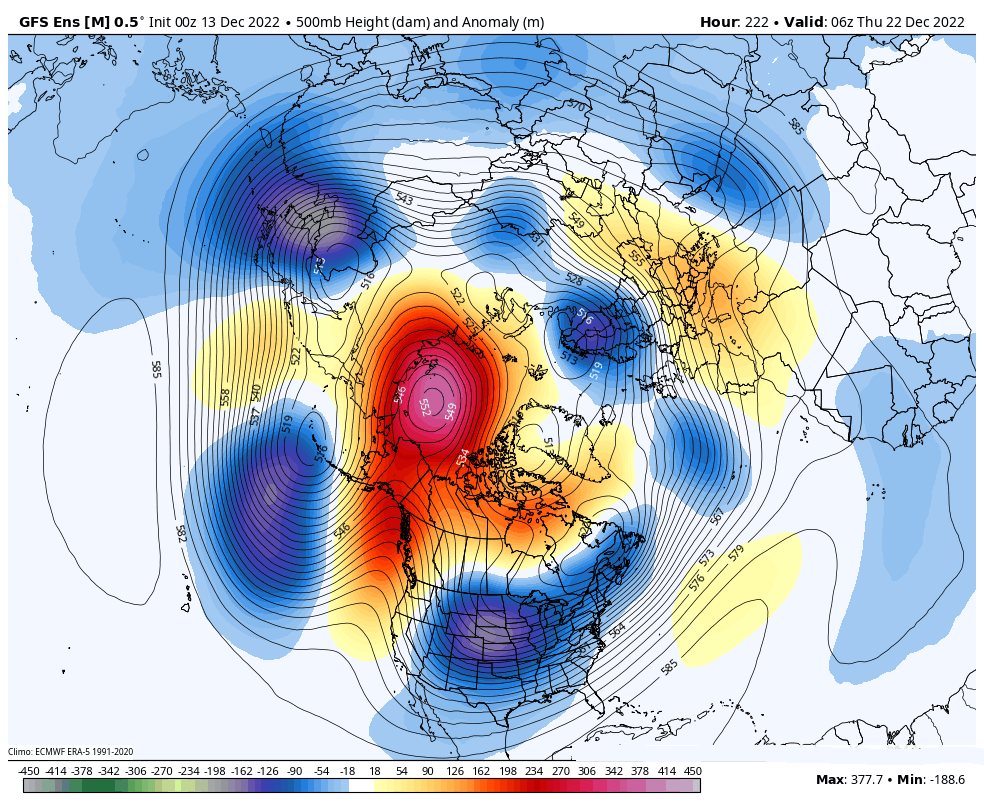
0z op models seem to be all over the place this morning with cold and magnitude next week. However, nearly all the ensembles from the CMC, ECMWF, and GFS are showing multi-day subfreezing temps at DFW with averages now down in the teens for lows. Several members show us getting to the single digits. If the GEFS (ensemble) 500 mb pattern is correct (below) Texas will take a direct hit. This will put challenges to the power grid. I think freezes all the way into LRGV look likely with this.
-
Texas/Oklahoma Discussion & Obs Thread 2022
DFWWeather replied to It's Always Sunny's topic in Central/Western States
Very much agree with you on this. Seems all the teleconnections are pointing to an Arctic outbreak. How severe will it be and will it affect Texas directly like in the two years you mentioned are the questions? With a higher than usual chance of snow or ice in our around Christmas this year, we may be looking at temps as cold as 10 or colder before all said and done at DFW. I don't think we will get as cold as Febrary 2021, nor do I think this will be as protracted as December 1983 though, at least not yet. -
Texas/Oklahoma Discussion & Obs Thread 2021
DFWWeather replied to It's Always Sunny's topic in Central/Western States
I've lived through several terrible ice storms in DFW. I'm not old enough (thankfully) to remember the event that occurred in Fort Worth in late January early Febraury 1949. 4 days of not-stop freezing rain and drizzle caused ice to accrete 7 inches thick. Also our temp dropped to -2°F with that event. That is the worst ice storm in Metroplex history. -
Texas/Oklahoma Discussion & Obs Thread 2021
DFWWeather replied to It's Always Sunny's topic in Central/Western States
I meant in relation to the GFS. It does a much better job of handling low level cold air. I bet the temp adjust on the 3km as it is just coming into range. NAM always starts off a little warm when coming into range then adjusts. -
Texas/Oklahoma Discussion & Obs Thread 2021
DFWWeather replied to It's Always Sunny's topic in Central/Western States
The NAM incorporates the GFS with higher resolution built into it. I would go with the NAM over the GFS. It is very concerning that the NAM is going with that much freezing rain. The 12z GFS is pretty bad with nearly 1/2 an inch of freezing rain. That is a lot of ice folks! It also is showing 1.5 to 2.0 inches of sleet on top of that for Dallas and Tarrant Counties. -
Texas/Oklahoma Discussion & Obs Thread 2021
DFWWeather replied to It's Always Sunny's topic in Central/Western States
The 6z models this morning of freezing rain amounts are getting into Ice Storm Warning criteria. Definitely think the Watch will get upgraded to a Winter Storm Warning as early as this afternoon, but certainly by tomorrow morning if trends continue with some counties maybe upgraded to an Ice Storm Warning. I am also growing concerned of severe cold Friday and Saturday morning into the Metroplex (ie. temps down to 10°F or lower), so we may be dealing with Hard Freeze Warnings also. The main point is models are trending colder with the the 32°F line on average expected 3 hours earlier than yesterday, approximately 9PM ish for KDFW Wed evening. ***12z NAM forecasting almost 1.00 inch of freezing rain for the Metroplex.*** -
Texas/Oklahoma Discussion & Obs Thread 2021
DFWWeather replied to It's Always Sunny's topic in Central/Western States
Winter Storm Watch issued for much of North Texas down to Hillsboro, including DFW. Waco is not included at this time. -
Texas/Oklahoma Discussion & Obs Thread 2021
DFWWeather replied to It's Always Sunny's topic in Central/Western States
Not really, it is going for more sleet as opposed to freezing rain. -
Texas/Oklahoma Discussion & Obs Thread 2021
DFWWeather replied to It's Always Sunny's topic in Central/Western States
The 12z GFS is forecasting at DFW Airport 1.7 inches of sleet and 0.26 of an inch of freezing rain. The 12z Canadian is going for approximately 0.10 of an inch ice accretion across the Metroplex and 2.00 inches of sleet all across the Metro. -
Texas/Oklahoma Discussion & Obs Thread 2021
DFWWeather replied to It's Always Sunny's topic in Central/Western States
Technically not in this case because of the wind moving heat away from the rain droplets. It actually will freeze closer to 32°F on contact than the usual 28°F. Great techncial discussion on that in the FWD AFD this morning. This setup is almost a classic textbook case of ice and sleet for this area. -
Texas/Oklahoma Discussion & Obs Thread 2021
DFWWeather replied to It's Always Sunny's topic in Central/Western States
It is still ingesting data, and I bet those amounts go up a bit into tomorrow. It is forecasting an inch plus of sleet which is still Watch criteria. Remember a Watch can be upgraded or downgraded to a Warning or Advisory. It also came in significantly colder with temps and much quicker with the 32°F freeze line in line with the other models. -
Texas/Oklahoma Discussion & Obs Thread 2021
DFWWeather replied to It's Always Sunny's topic in Central/Western States
Looks like 12z NAM has come aboard. Winter Storm Watch probably will get issued this afternoon. -
Texas/Oklahoma Discussion & Obs Thread 2021
DFWWeather replied to It's Always Sunny's topic in Central/Western States
The delay in the Winter Storm Watch is because of the NAM. This model is usually king in its handling of shallow/dense Arctic airmasses and it is delaying the arrival of the coldest air. It is the model that has thrown the monkey wrench into this forecast - lol! This has huge impacts on forecast amounts with the NAM showing hardly any accumulation. It also is keeping the storm track a bit further north. I must say this is pretty unusal. It also should be noted, the entire 0z suite of CMC ensembles have warmed from where they were, though the operational has not really. The ECMWF, ICON never get us below 20°F with this event, or just barely in the case of the ICON. The ECMW is also a bit delayed on the 32°F arrival of air into the Metroplex. Given past experiences with 1050 mb Arctic highs, I don't see what would hold up cold air like that. I would side with the colder faster solutions. The amounts forecasted above by the FWD NWS is in line with Winter Storm Watch criteria. I would have issued the Watch. It can always be canceled or downgraded to an Advisory (that is exactly what a Watch is for anyhow). If they were making a decision on a Warning, I would have held off. -
Texas/Oklahoma Discussion & Obs Thread 2021
DFWWeather replied to It's Always Sunny's topic in Central/Western States
Absolutiely, mind boggling totals coming off the 0z suite of data this morning. 2.00 inches of liquid into subfreezing air on some of these models...just wow! If that falls as freezing rain, we are talking a severe ice storm that would go down in the record books. The NWS is fully on board this morning. The latest concern is that DFW (presuming we get some type of ice or snow and it wouldn't take much) would have to deal with severe cold both Friday and Saturday mornings (ie, temps dropping below 10°F). Interestingly enough, the ECMWF is the warmest of all the models keeping us in the 20s the entire time. I believe it was also the warmest model last year. The 0z ensemble average off the GFS is 10°F for the low at KDFW on Friday morning, which says alot. I wouldn't be surprised by tomorrow Winter Storm Watches start to get hoisted. If freezing rain still looks the predominant precip type, I bet some of us will make Ice Storm Warning criteria easily. Not to meniton a Hard Freeze Warning and Wind Chill Warning at some point too. -
Texas/Oklahoma Discussion & Obs Thread 2021
DFWWeather replied to It's Always Sunny's topic in Central/Western States
Latest 12z ECMWF fully onboard with icemeggeddon sleet/freezing rain for DFW with a lot of freezing rain, then brief changeover to sleet/snow. -
Texas/Oklahoma Discussion & Obs Thread 2021
DFWWeather replied to It's Always Sunny's topic in Central/Western States
What we are dealing with here is a 1050 give or take mb Arctic high plunging into the US. The leading edge of the Arctic airmass plunging into Texas is very dense but shallow (at least initinally where much of the precipitation will likely fall). This points to more ice than snow. What you are likely seeing on the ICON model is (and I am not as familiar with this model's biases) that it likely is not resolving the low level cold air well. I could be wrong. It may also just be speeding the low up and delaying the cold air (not a likely scenario in this type of setup). While I concede the NWS point about modeling and we should not get hung up on type or amounts at this point. When you have a preponderence of models showing a similar outcome, the main message is that the odds of some type of impactful Winter Storm affecting the region north of a line from El Paso, South of San Antonio, south of Austin into the northern suburbs of Houston area are increasing. There was a slight increase in temps on the 0z data, but 12z is colder again. I am talking increase instead of severe cold (temps below 10 at DFW), just temps in the teens at the coldest point. We are not seeing an increase in temps like you are suggesting where this will be a borderline type event. If there is precip of anykind in temps like that it will cause problems regardless of amounts. Even the NDFD number is down to 16°F today at DFW. Having looked at the 12z ICON...it has 2m temp of 19°F at DFW with precipitation. That would be freezing rain or sleet. -
Texas/Oklahoma Discussion & Obs Thread 2021
DFWWeather replied to It's Always Sunny's topic in Central/Western States
Today's 0z and 12z Canadian and all of its ensembles are are just as bad with ice/sleet for DFW if not worse, particularly the 12z op Canadian. Should also note the ICON and JMA are showing stuff too. -
Texas/Oklahoma Discussion & Obs Thread 2021
DFWWeather replied to It's Always Sunny's topic in Central/Western States
I like how in that same discussion they said a 2% chance that we get as cold as last year. Um, that is like once in 30 year event. The fact that we are even talking chances on that is ridiculous. I have noted that nearly all 0z guidance is a bit warmer this morning at both the surface and H85. So any ice snow would make the difference on just how cold it gets. -
Texas/Oklahoma Discussion & Obs Thread 2021
DFWWeather replied to It's Always Sunny's topic in Central/Western States
Look like the entire suite of 0z guidance this morning and their ensembles from the GFS, Canadian, and ECMWF are onboard for a crippling ice storm for the DFW Metroplex for the Feb 4th timeframe. -
Texas/Oklahoma Discussion & Obs Thread 2021
DFWWeather replied to It's Always Sunny's topic in Central/Western States
I bet if the northeast was not having the big blizzard this weekend, the news would be all over this given what happened last year. -
Texas/Oklahoma Discussion & Obs Thread 2021
DFWWeather replied to It's Always Sunny's topic in Central/Western States
0z and 12z op ECMWF appear on board...though the 12z is slowing the cold air intrusion keeping precip liquid. Typical bias of this model in this situation. It looks like a dense/shallow intrusion at least initially which might not get properly resolved until the NAM comes in range. This also points to more of a ice event vs snow this time. Interesting note: 12z GFS ensemble average temp is down to 14°F for DFW. There is quite a few of them taking us into the single digits. Wow! -
Texas/Oklahoma Discussion & Obs Thread 2021
DFWWeather replied to It's Always Sunny's topic in Central/Western States
I am not sure to what you are referring, but the latest 12z op Canadian has a low of 13°F at DFW on February 5th which is indicative of a significant Arctic air intrusion. Nearly every run of the 12z Canadian ensembles show QPF for DFW, which given temps would be some sort of snow or ice. The operational does not have much in the way of precip. However, the op 12z GFS is icemeggedon! What I am strongly bullish on is a significant cold air dump. -
Texas/Oklahoma Discussion & Obs Thread 2021
DFWWeather replied to It's Always Sunny's topic in Central/Western States
I completely agree! This is the best pattern and chance I've have seen this winter for significant cold air dump and, in particular, wintry precipitation. Some models spreads showing potential of upwards 30+ degrees below normal for the DFW area. This is an excellent pattern if you are a lover of winter weather. Unfortunately, if we get a Arctic dump of this magnitude, it will again put strain on agriculture, infrastructure and the power grid for much of the state, much like last February. What is interesting is nearly every major global model and much of their ensembles have been in remarkable agreement in the evolution of the pattern since Monday. Something to watch for sure! Having said that though, I am a bit on the skeptical side on precip largely because we have been devoid of any significnat precip here for months now (what October last time we saw more than an inch?). Much of the state in entering into severe drought status. -
The snow records at DFW only go back to 1940. The average annual snowfall at DFW from 1940 to today is exactly 2.44 inches per year. If we had a complete snow record back to 1899 it would likely be a bit higher.