

SN_Lover
-
Posts
4,596 -
Joined
-
Last visited
Content Type
Profiles
Blogs
Forums
American Weather
Media Demo
Store
Gallery
Posts posted by SN_Lover
-
-
The GFS was not good in any way. Stratosphere cooling and the polar vortex retreating to the poles. The SE ridge giving us winter lovers the middle finder and a stout - PNA trough. And what's a -NAO look like because those are more rare than unicorns.
-
-
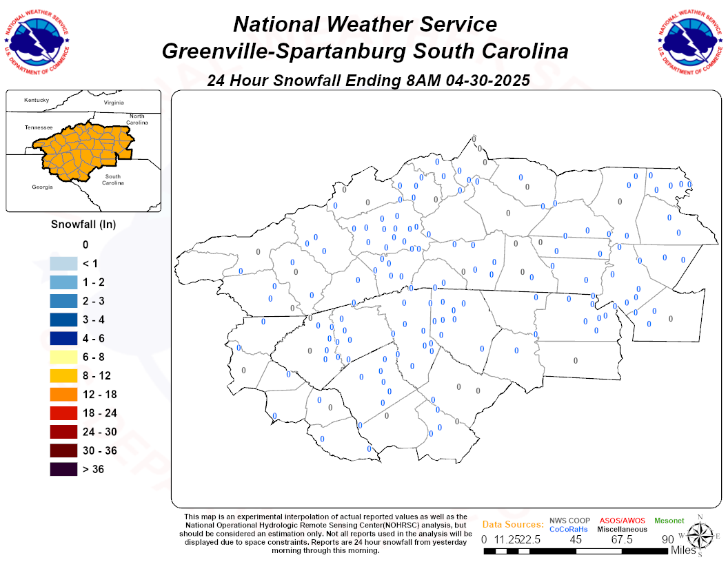
Over-performer incoming! Models under doing the CAD.
-
CAD is now eroding. DP's should gradually rise the next several hours. Melting should begin now through tonight for most NC locations. Great for the kid's. They won't be out of school that long!

-
4 minutes ago, EastonSN+ said:
If u go to the NWS webpage u can submit your snow report
-
Mooresville just or over 3.5". The sleet cutoff never ceases to amaze me. Glad i didn't fly back home for this one.
-
 1
1
-
-
The Statesville sn/ip/zr line in full effect on the NAM.

-
2 minutes ago, SLAMSTORM22 said:
10-16" is my computer generated forecast in Mooresville, seem legit, or too high?
(it actually shows 9-15" for concord also)
Sleet line stops at Statesville usually. 4-7" would be a good call.
-
 1
1
-
-
9 minutes ago, SnowDawg said:
FWIW 3km NAM still looking colder than 12km at 25.
Earlier runs of the NAM had the transition zone correct. Went through RDU's records for combination winter storms of date and magnitude and could not find anything. Whichever p-type you get, this will be downright historic!!
-
Same thing time after time. Models underestimate the warm layer and the sleet line advances north and everyone vents on here because they didn't get their GFS 2 feet. Sometimes you need to apply common sense and realize this is the Carolina's. end of rant.
-
1
-
-
2 minutes ago, friedmators said:
I mean it only initialized 30mb high. Let's run with it!
It's not that. Ridge is stronger...


-
0z NAM is actually SW at 30.
-
6 minutes ago, bdgwx said:
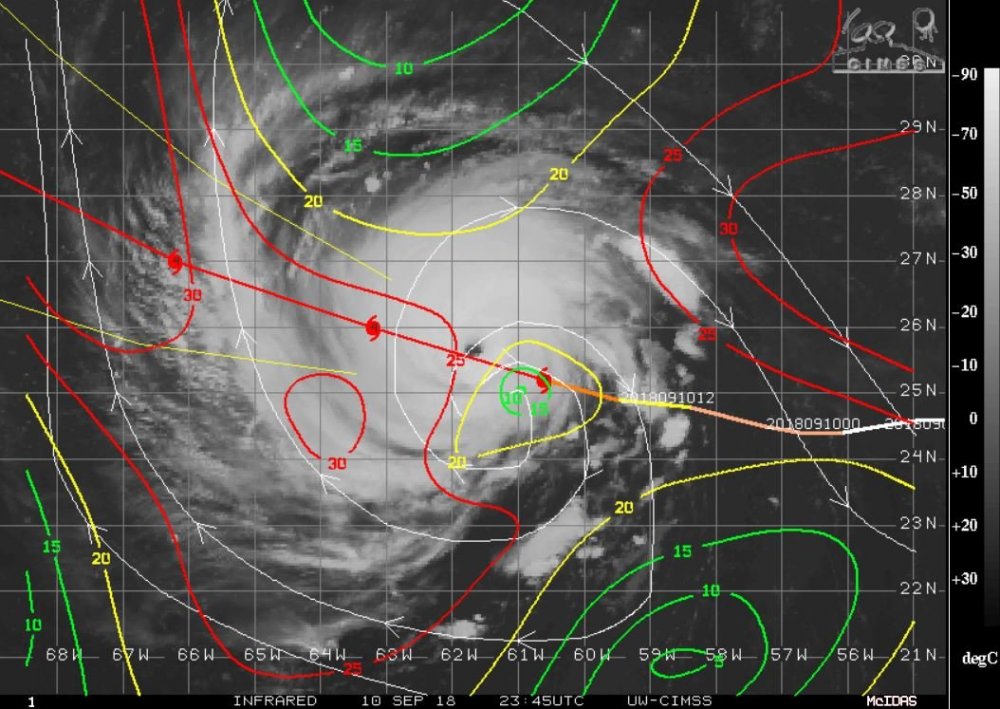
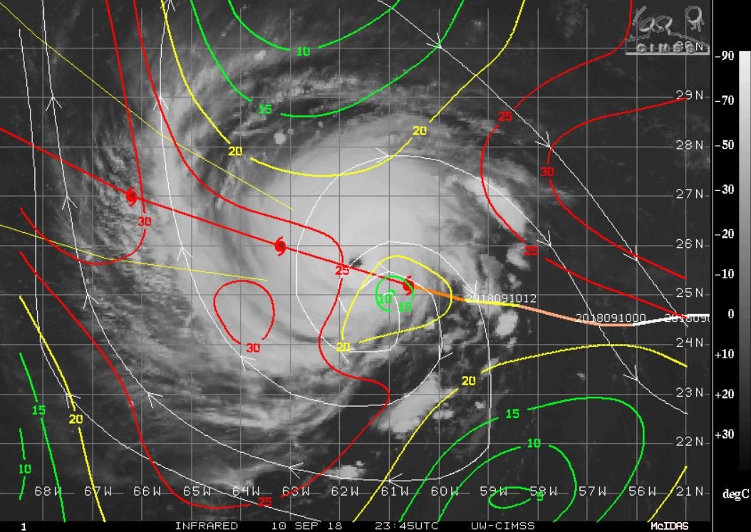
The green tracks (TABS, TABM, TABD) are the beta-advection models. They use the mean flow of the GFS winds over different layers with a correction made for the beta drift. The different variations loop in different ways depending on how deep of steering flow you want to consider. S is for shallow, M is medium, and D is for deep. They loop largely because the GFS shows a breakdown of the steering flow. It's my understanding that a skilled forecaster can make some interesting inferences about the cyclone environment based on the TABx tracks. As a general rule you'll probably want to ignore them and instead focus on TVCN (or maybe TVCX). It is the consensus of the best track models which as of 2018 are an equal weighting of GFS, ECMWF, UKMET, HWRF, and COAMPS.
Also, the beta models can be run on your cell phone. they are not reliable.
-
 1
1
-
-
5 minutes ago, csnavywx said:
Careful with that shear product. Some of that is contaminated due to storm outflow. Actual shear is only about 5 knots right now. There's a bit more on the southeastern side of the circulation (you can see the outflow restriction there) and that might be responsible for part of the more poleward motion than expected in the last several hours.
Edit: The shear product lags the TC center since it is only updated every so often. You can see where the TC center was actually analyzed at the time.
I think the shear analysis was taken 1-2 hours ago. What about the dry air?
-
Florence does not look good on WV or IR. Going into a area of very strong shear and dry air...

-
1
-
1
-
-
3 minutes ago, Brick Tamland said:
Hoping it does weaken fast once it comes inland. Looks like the NHC has it down to 70mph now instead of 100 mph like before once it comes inland.
Actually 140mph

-
1
-
-
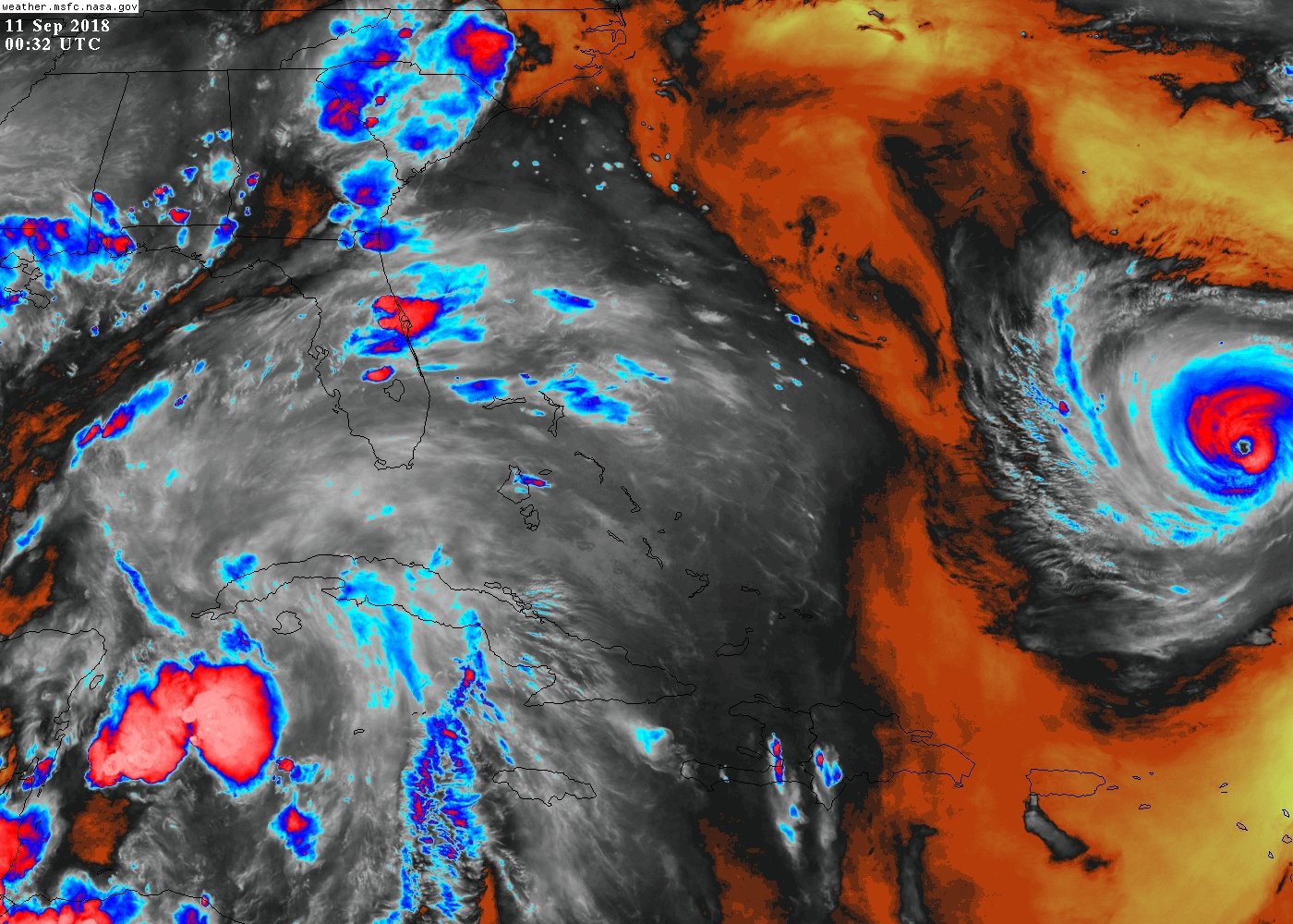
Really sad. I went and ate on the island today and it was like a funeral in the restaurant. Everyone was rightfully scared. It's a sad situation all around. I know weather enthusiasts love this, but i now see it from a local perspective and it's depressing. I hope it curves out to see
7 minutes ago, HKY_WX said:This has potential to blow fran away from all aspects. This will be a massive blow ala hugo and hazel on the coast/interior wind wise if projections are right, with floyd or Harvey flooding potential.
-
 2
2
-
-
4 minutes ago, BIG FROSTY said:
Euro has 33 inches of rain forecasted with Florence, Expect those totals to be higher in those mountains, 3-4 feet of rain some places in coming 10 days
This will be almost Biblical if the Euro verifies. We joked about harvey when the Euro was showing it, im not joking now
-
2
-
-
25 minutes ago, AJF0602 said:
Jacksonville, NC here, I love extreme weather like this but have an eerie feeling. Florence is quickly getting organized again, its fascinating to watch the Goes east visible floater.
Same. I'm on the top floor of my apartment. Inventorying everything today just in case of landfall for insurance.
-
3 minutes ago, Orangeburgwx said:
No, it's a bit slower
True, but shouldn't make too much of a difference.
-
GFS looks unchanged
-
It's a pain to display on GRADS. Me and my research mentor had to contact NCEP. You have to do something with a file to get it to display right.
-
8 hours ago, Tarheel17 said:
From Brad Panovich.

Literally the most humid summer since 1971, if not ever, and it's not even close. Fall can't get here soon enough, but no end in sight in the medium-term.
Stay tuned for this Winter's most popular hit "My wet-bulb is too high" followed by "2 inches of sleet, washed away by rain"
-
 1
1
-
1
-
-
The tale of 2 seasons on the GFS

-
1
-

Banter Thread
in Southeastern States
Posted
I can't remember the last time we had a major severe weather outbreak. Wounder what this spring will be like.