.jpg.55167780a4ecb1eb92600eefed007ebf.jpg)

weatherbo
-
Posts
6,333 -
Joined
Content Type
Profiles
Blogs
Forums
American Weather
Media Demo
Store
Gallery
Posts posted by weatherbo
-
-
43 minutes ago, (((Will))) said:
I just saw this. YES!
My storage cabin and garden shed

-
 7
7
-
-
Upgraded to a blizzard warning... Feb '15 was my last one.
Baraga-Marquette- Including the cities of L`Anse, Gwinn, and Marquette 747 AM EST Sun Feb 24 2019 ...BLIZZARD WARNING IN EFFECT UNTIL 1 AM EST MONDAY... * WHAT...Blizzard conditions developing late this morning and continuing into this evening. Additional snow accumulations of 10 to 17 inches, except 5 to 8 inches near Skandia and Marquette and 2 to 4 inches south of Gwinn. Northwest winds will gust as high as 55 mph this afternoon and evening.
-
Over 8" of intense snow since about 3 this morning, combined with yesterdays 4", already sitting at a foot of new snow with another foot to fall. I have to assume the depth is somewhere around 65". I did see an official co-op depth about 20 miles sw of here at 60" this morning.
MQT- 11.7" since 7 am yesterday.
0700 AM SNOW 4 NE NEGAUNEE 46.53N 87.55W 02/24/2019 M8.0 INCH MARQUETTE MI OFFICIAL NWS OBS UPDATED TOTAL SINCE 230 AM. LIQUID EQUIVALENT IS 0.93 INCHES. SNOW DEPTH IS 53 INCHES. STILL SNOWING, THOUGH INTENSITY HAS DIMINISHED TO MODERATE SNOW.-
 1
1
-
-
14 minutes ago, TugHillMatt said:
In some ways, it is a good thing for me right now to not have to deal with winter storms so we can get stuff moved to my parents house. Stress is sky high for me right now with having to pack up a house the second time in a year, look for jobs, apply for jobs, and check out places.
My wife's car broke down, I developed a sinus infection, wife's sister is dealing with flooding in Tennessee, and we just found out her uncle has 24 hours left to live. Not to mention several other things going on...
Matt, I am so sorry to read of your situation. That is some serious stress. I really hope things work out for you.
-
1
-
1
-
-
A blizzard warning remains a possibility
MQT
Snow will still be heavy thru the morning across the w and n central as cyclonic flow backing from n to nw and caa bring increasing lake/upslope enhancement. While there is considerable ice cover over western Lake Superior, strong winds will open up larger gaps in the ice to allow for an increase in lake heat/moisture fluxes. Winds fields will rapidly strengthen on the backside of the departing and still deepening system. 850mb winds are fcst to increase to 50-60kt during the day. These strong winds will displace upslope/lake enhancement farther inland than normally occurs. Often in such cases, enhancement will be displaced beyond the Keweenaw, and may end up with Baraga County/parts of Marquette County sw into southern Ontonagon/nw Iron County seeing the best enhancement despite nw winds in the aftn
Fortunately, strongest winds don`t coincide with heaviest snow occurring overnight tonight into Sun morning. Nonetheless, quite possible blizzard warnings will need to be hoisted for Sun aftn into Sun night where nw flow upslope/lake enhancement is most persistent.

-
1
-
-
7 minutes ago, (((Will))) said:
Not saying he lives in Lake Linden (he did way back) but Lake Linden is the most obvious elevational difference.
Dee lives south of Mohawk but several hundred feet lower.
Lake Linden also downslopes from the spine
-
48 minutes ago, (((Will))) said:
Several hundred feet lower than I am. I'm at >1200, he's around 750-800 feet. You see a sharp change on the spine of the Keweenaw. Lake Linden is 4 miles away and has much less snow.
That's nuts... I've followed him since I was like 15. His snow depth even in Lake Linden was always Impressive. Usually peaked in March, and was at the most 4'. I know his newer location is much better than Lake Linden. I see extreme snow depth differences between here and Marquette, as well, so yeah.
Full sun and a high of 31 today caused the snow pack here to shrink a couple inches... stake is reading 54" before the storm. I'm thinking you will get your blizzard warning you're wanting.
-
2 minutes ago, (((Will))) said:
Nearly 300 inches of snow this year, close to 70 inches on the ground - and still haven't had a blizzard warning in the past 600+ inches of accumulated snow going back through the years.
Is this because I'm black?
How far is John Den from you? I was thinking less than 10 miles, but I'm not positive.
His stats as of today are nowhere near 300", neither am I.
Snow Data as of
9 am February 22, 2019New snow in the past 24 hours: 0.5″ Snow on the Ground: 47″ Season Total to Date: 214.5″ -
1 hour ago, Geoboy645 said:
How much on the ground then? 90"?
LOL. I have no idea how much snow it would take to reach a 90" depth. If models are correct, I could see having a depth of 70", maybe....
12z NAM crushes here.
-
woo hoo! Winter storm watch posted.

-
1
-
-
Storm is looking less and less appealing. SLR's as low as 8:1 with the possibility of mixing even being mentioned. I'd prefer a fluffier 15-18:1 type snow. After clearing and shoveling 75+ inches in three weeks, I'm pooped.
I am, however, looking forward to the possible blizzard conditions following. New generator just waiting

Guess I need to get some extensions like MQT added the their snow stakes. Mine is measuring 56", so should easily go back over 5' again.

-
2
-
-
It's F'n deep up here


-
1
-
-
4 minutes ago, Stebo said:
Man, I really hope there is no early season heavy rain event up there. It is going to be a disaster. Can you still see your house?

According to MQT, their snow pack there has a water equiv of 9", I probably have 10". Could spell another disaster on the Dead River just south of me like 2003, I think it was. Heavy rain and rapid snow melt. And I keep thinking, there's still 6 weeks left of good snow climo.
Snow is up past 50% of most windows.
-
2
-
-
10 minutes ago, michsnowfreak said:
You are easily the snowiest place in the upper peninsula I would imagine. You should be an observer For the MQT NWS. I'm very proud of my continuous observational record, though I must say I honestly do not know how you would record snow depth. That's usually something that you have to take several averages of and your snow so ridiculously deep all you can do is put out a stake in your best guess of a location with minimal drifting or blowing because you sure as heck can't walk around in it every day to take several measurements if needed lol
I'm pretty sure there's places in more remote areas that receive more snow than me, it just isn't measured by anyone... just west of here, and places in the Keweenaw see as much, if not more on a yearly basis. What makes this place special, is the fact that I sit high on a north facing ridge, with upslope in all but a few directions... it's really a unique spot.
The six years I have been here, tho, this is the deepest depth I have seen, and the most snow at the current to-date period. I can see hitting 300" possibly this year.
And you're right, the snow is pretty much impossible to walk through, and exhausting to even snowshoe at this depth. It's almost claustrophobic.
-
Around 6" of snow today, monthly total well over 70", snow up to my chest (I'm 6.2')... possibility of 1.5-2' of snow this weekend.

-
7 hours ago, josh_4184 said:
I was away on a little trip with the family last week but when got back home was pretty surprised to see how much LES we received last week. I would say average depth is around 36" with other areas well into the 40" around the property. I will admit I had given up on this winter with the early season woes and being almost 35" down on this season but this second half has really been something. Oddly enough i am ready for spring, LES guns are not going to be firing at full anyhow with the growing Ice Pack on the lakes. Looking at the next ferw weeks still looks pretty set in full winter mode for most of the upper Midwest.

Edit: Gazing at today's satellite, looks like there is much more open water than this graphic depicts which is not all that uncommon,
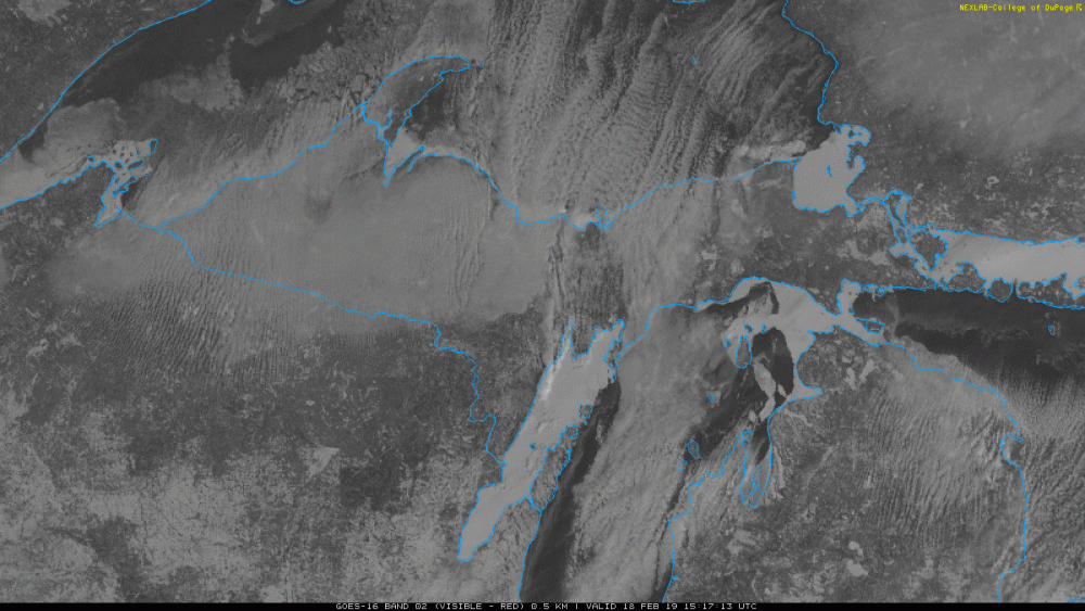
There's still plenty of open water. Twin Lakes area received 30-36" a few days ago because the ice shifted and a crack opened. Northern Lakes are freezing quickly, however..
-
I don't think I'm ready for this jelly
.thumb.png.b625a280550636fee642a4938ae3fd11.png)
-
Most back roads up here that aren't seasonal are plowed, just narrow. I suspect once the Marquette road commission is caught up in towns, they’ll then come back through and push the snow back, further widening the roads. My road is basically a path still... haha! Snow's too deep to sled, too deep to snowshoe, just these massive walls everywhere. Spent hours yesterday clearing the seasonal roof snow away from the house that we shoveled off last week, which is basically like packed avalanche snow.... and looks like several inches fell while I was sleeping. Just constant snow removal this month and it looks to keep falling through the rest of the month with regularity.
6 hours ago, CoalCityWxMan said:How do you even get around at this point?
-
2
-
-
Brief clearing today between lake snow

-
2
-
-
Been pounded by snow all afternoon. This morning there was no accumulating snow in the forecast, and it has snowed all day, with significant accums somewhere around 8-9" and still heavy...no advisory or anything. Nearing 70" this month.
I have never seen such deep snow.
-
1
-
-
4 minutes ago, UMB WX said:
It's tough. Seems we can't shake off a easterly wind until July of late.
uh huh!
-
1
-
-
13 minutes ago, UMB WX said:
Sounds about right this winter. Couple taste of winter than a cutter to nuke us only to go back to winter like stuff. Feelings of a miserable spring incoming again.
Do you even have Spring iyby?
-
wow @ Twin Lakes

-
3
-
-
24 minutes ago, wishforsnow said:
Marquette NWS reported up to 36 inches of snow from the Porkies to Twin Lakes. My parent's live out in Twin Lakes and can confirm this. Healthy convergance off of the increasing shirking open water on the big lake. Only about 5 inches here in Hancock. The convergence spread over to Baraga/L'anse where they reported a foot and they are right on the lake shore. I was wondering why they closed school there when there wasn't even any advisory out at the time of the cancellation.
Next clear day should be interesting re: the lake ice. I'm betting this wind has opened up a lot of water.

.png.6f2daaef397d2fc4a65526a307905e6e.png)
February 23-25th Winter Storm
in Lakes/Ohio Valley
Posted
the blizzard winds are not even here yet.