

RCNYILWX
-
Posts
3,169 -
Joined
-
Last visited
Content Type
Profiles
Blogs
Forums
American Weather
Media Demo
Store
Gallery
Posts posted by RCNYILWX
-
-
Our collaborated ratios were in the 7-9:1 range for the western and northwestern burbs during the day on Friday and I was good with those as a starting point. Temps are marginal so 10:1+ seems unlikely. South of I-80 and the city I had ratios as low as 5-6:1, so we certainly didn't go high with ratios.What is your personal take on ratios in the farther outlying suburbs around the city?
Then Friday night on the backside, they come up to 10-12:1 (highest inland) during the evening. Of course this is all contingent on keeping snow as the ptype.
Sent from my SM-G998U using Tapatalk
-
 1
1
-
-
Honestly, certainly couldn't discount a warmer outcome, but we were looking at a bit south of I-80 (aside from the very real lake influence) on too much uncertainty for a watch.Was the city/south end of the winter storm watch debated heavily internally? Or was there good agreement?
I do think it's going to be white rain near the lake on Friday, but my thinking is that the 700 mb and 850 mb low tracks with this per the very consistent ECMWF and recently more consistent GFS are more favorable to keep things heavy wet snow away from the marine bubble on Friday.
Definitely uncertain how far inland the lake influence on accums gets, but [mention=9209]mimillman[/mention] noting the difference between Wicker Park and the Loop yesterday afternoon swayed me to use the Dan Ryan as a rough demarcation zone.
I was most on the fence about Livingston (not included), Kankakee (included), and Lake and Porter, but IWX wanted LaPorte in and I was fine to put them in the watch for collab purposes. WPC has an internal watch proposal that actually had the whole CWA in it.
There was good agreement for the purpose of watch issuance in what we went with, and didn't consider not including central and southern Cook because of inland portions of those zones currently look good for warning level impacts per global consensus.
Officially had about 5" along the Chicago shore, which very well could still be a bit high depending on how long temps take to cool Friday evening.
-
2
-
-
If anyone has specific LOT centric questions on forecast stuff from today, ask away and I'll try to reply a bit later.
Apologies for the lack of a more in depth meteorological dissertation in the AFD lol - just less and less time available for us on days like this.
Sent from my SM-G998U using Tapatalk-
 2
2
-
10
-
-
The second half had a much better air mass, but the front end Saturday night all the way into or through that Sunday morning was lower ratio with temps near freezing. This looks more marginal than that and the lake had some ice on it, or was near freezing at least.
GHD2 can’t even get a mention.
With that one temps dropped quite a bit during the long-duration storm. With this one temps will not crash until it’s pretty much wrapped up, as currently modeled that is.
So easy toss.
Main point about GHD II is that if we don't get dry slotted or too warm aloft, we can pick up a good amount of snow with more marginal temps. And in this case, there's been good agreement to this point on the deformation Friday night having a much better air mass coming in.
Sent from my SM-G998U using Tapatalk
-
1
-
-
Plan is for me to do the forecast for the storm today. Definitely a risk with ptypes into the metro, though recall that GHD II started out pretty warm too. So hopefully we find a happy medium. The Chicago shore could be a bigger issue again.
Sent from my SM-G998U using Tapatalk-
5
-
 1
1
-
-
Goes without saying but a really high end solution from the Euro. Powder keg of a setup if things break right.
-
3
-
-
Some would say the new hotness. Lol
Update…
.
-
Started snowing recently here in southeast/south central Naperville. Coming down at a decent clip but small flake size for now.
-
1
-
-
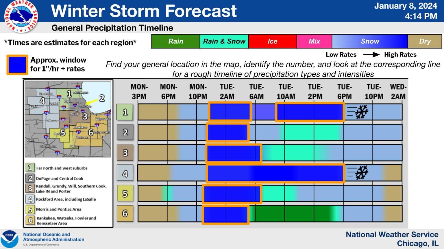
^Thanks! Feedback like that is helpful for us, as we constantly fine tune out graphics. We've gotten a lot of good feedback on the ptype timeline since we went to it over the past few years.
-
7
-
1
-
-
I think your latitude helps but if there's gonna be an issue in Lake County it'll be the southeast.I really think the LOT has the right idea here. Except there will prob be some liquid up here too.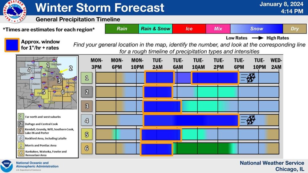
Sent from my SM-G998U using Tapatalk
-
As you'd expect, crazy day at LOT today. Will try to chime in this evening and then try to sleep. Back in at 7am tomorrow as the shift supervisor. Roads should be fun lol.
-
14
-
-
I think it's a relative thing. The Euro is still the best model but the other models are better than they were due to computing power. Back when these forums got popular, the Euro was much better across the board, so even if it had similar or more fails, the other models had fewer successes.I can only speak for myself, I haven't seen too much trash talking the Euro other than stebos comment and my response. Basically, years ago the Euro used to be the far superior model and recently it seems to not be. Not that it's extra bad or anything, but it's not that juggernaut it once was.
Another aspect I think of with modeling is the minor drawback of much higher resolution. In complex patterns with multiple moving parts, the error introduced by a higher resolution depictions can multiply in a way that may result in somewhat less stability run to run, such as what we were used to seeing with the Euro.
Since the ensemble members themselves are higher resolution, they may be affected as well. I'm speculating, but perhaps this is an issue with the guidance being phase happy, or with handling convection at times?
-
4
-
2
-
-
The 03z RAP had a very impressive depiction of the front end WAA snow tomorrow night. It's a plausible solution, if not in the top end amounts but the idea of several inches, given PWATs nearing 0.7" (0.6" is considered very high for snow), steep mid-upper lapse rates, slantwise and at times upright instability, and strong lift.
For the areas that max out, 1"/hour rates appear likely, and potential for 2"/hour is there.
Was texting with our lead forecaster on midnights for the storm, Carlaw, and he thinks TSSN is a decent bet.-
9
-
2
-
-
With the caveat that I've been off since Thursday and been more casually following than when I'm also working (I'll be back in tomorrow morning), I was a bit surprised how bullish they went with the snow forecast.DVN has the point/hourly forecast snowfall amounts up to nearly a foot here, and a few tenths over a foot for the QC. Seems pretty overdone as most guidance has QPF in the 0.6-0.9" range. Even accounting for higher LSR during intense banding, that may get canceled out by poor rates in the lulls in intensity many of the models show later tomorrow night into Tuesday. I'd probably go 6-8" with isolated higher amounts if I were making an official forecast. If the intensity of the deform band later Tuesday overperforms then DVN could end up being not too far off perhaps.
You can tell it's an aggressive forecast on the probabilistic winter page, https://www.weather.gov/dvn/winter.
Their expected forecast is not far off from the high end amounts, which are the 90th percentile of the distribution and are closer to the 90th percentile than the low end amounts, the 10th percentile. Ideally, we're probably closer to the middle (50th percentile) of the distribution at this range.
-
2
-
-
Easy to forget because we've been tracking so long, but a SLP pressure in the 980s is plenty strong for this area. If low-mid 980s means more snow for more of the metro, easy choice.it's everyone for themselves. Do you want a amped 3"or a flat 6". I know where I stand.
Need the track to not be hard NNE from near STL to keep the dry slot and warmer temps aloft farther southeast. A slightly weaker system would help with that.
-
1
-
1
-
-
You're in the LOT CWA right? I can't see locations on Tapatalk. Would pass your report to the office if they could use a few.2.4” from yesterday evening into the overnight hours. Quite a surprise.
Sent from my SM-G998U using Tapatalk
-
Regardless of the exact outcome snow wise, this storm is a big win for the medium-long range guidance. The general idea of a deepening SLP track toward the western Great Lakes has been locked in at a well above average lead time.
-
11
-
-
And UKMET, if you want to hold out hope. I'm definitely less optimistic for this area but still going to give some time. Also, unlike some other misses in the past, we'll get in on the front end thump of snow..jpeg.9819d54b0d0bfcec4ace3890d9b84a2a.jpeg)
-
2
-
-
I wouldn't be surprised at a similar snow distribution to 11/25/2018 if the track doesn't nudge back southeast.
Don't discount the front end thump being productive though even into the city. Consider that a relatively modest upper wave produced localized 5" amounts with a similar thermal profile last night.
Where you have strong lift well aligned with the DGZ, and steep lapse rates in the DGZ, you can get pockets of higher ratios even with temps around freezing. That's something the Kuchera maps won't pick up on.-
2
-
3
-
-
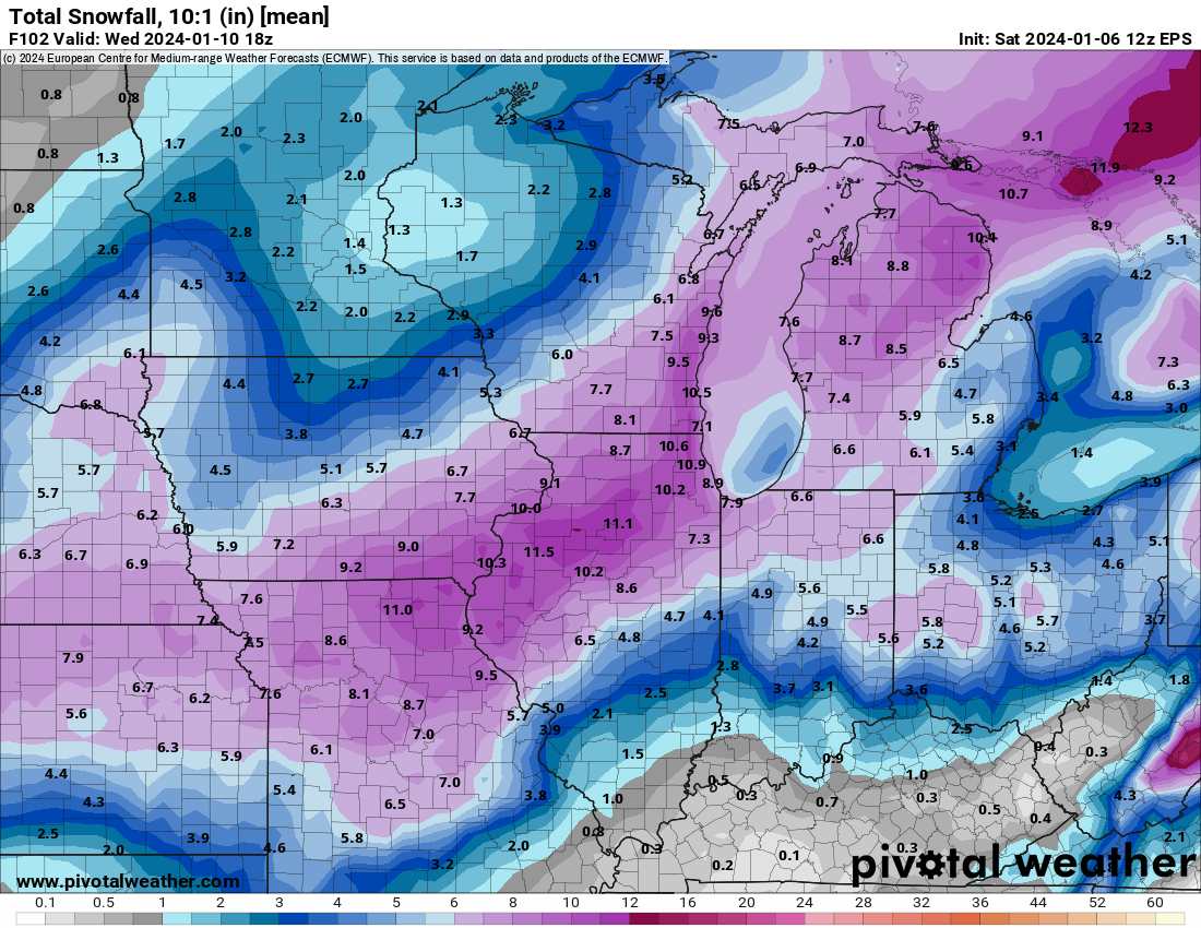
Here's the depth change mean. The answer is probably somewhere between this and the Kuchera ratio stuff. 10:1 ens maps at least give a good idea of the heavier snow swath.Keep n mind that's 10-1. Will be closer to 7:1 and in a tough environment
-
2
-
-
Every storm is different and you may very well be right, but the GFS/GEFS has been a bit too amped at this range with southwest type systems at this range over the past few winters. It's gonna be close and I feel better out here than I would in the city. The EPS mean SLP track has also jogged NW some vs. previous cycles.850mb doesn’t heat up as much on the EPS as it does on the GEFS. With this track I’d tend to lean more with the GEFS unless this trends back southeast
-
24-hour 4"+ probs12z EPS... much better for the lake shore than the GEFS.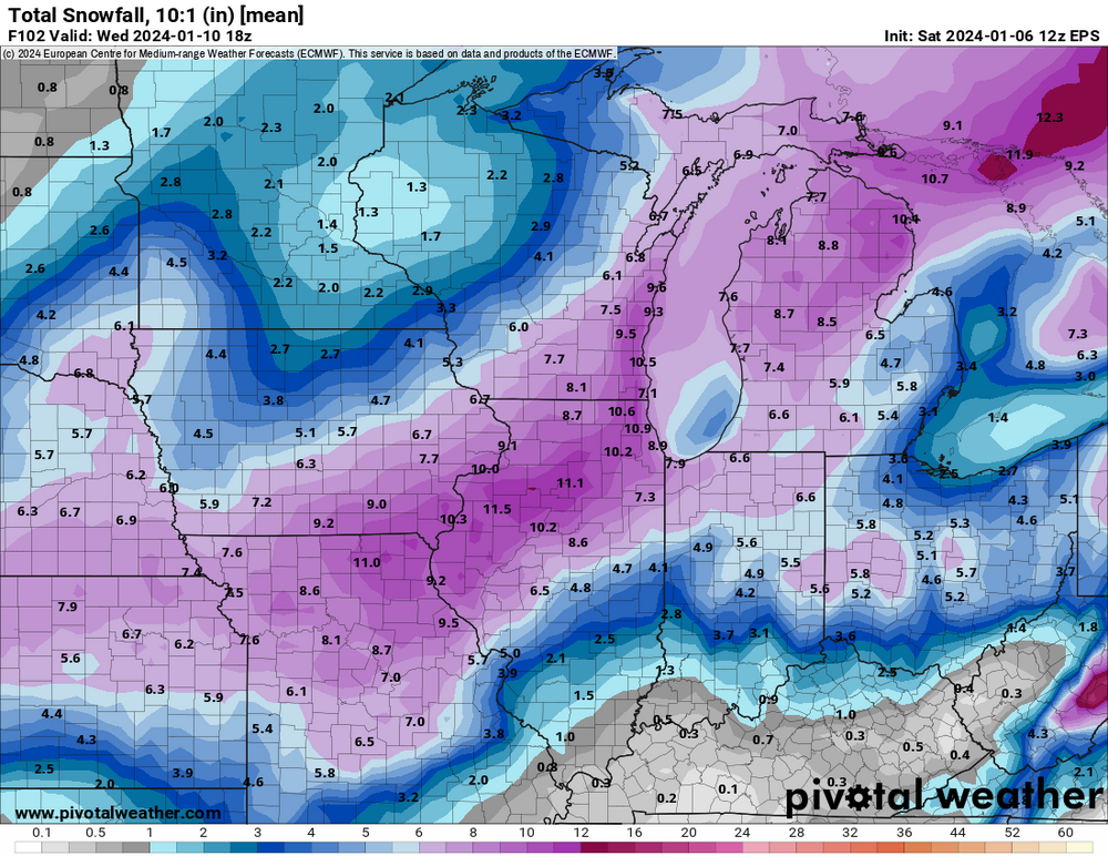

Sent from my SM-G998U using Tapatalk
-
3
-
-
You have competing factors - there is downstream -NAO blocking but it's in a bit of a low ebb as a 50N/50W low kicks out. Meanwhile, it's a dynamic, deepening system that wants to cut at least some due to height rises/latent heat release out ahead of it.[mention=3997]RCNYILWX[/mention] If you don't mind, what are your thoughts? Will we see a continued NW trend or some modulation back south?
I don't think it's going to go substantially NW bc of the downstream blocking but unfortunately we'll probably be riding the line due to the lack of an entrenched colder air mass that could have had the baroclinic zone farther southeast. We might have more wiggle room in the western suburbs than in the city and due south burbs.
Sent from my SM-G998U using Tapatalk
-
2
-
-
Kuchera version, just for posterity
First is run total and 2nd is 24 hour.

Sent from my SM-G998U using Tapatalk
-
2
-
 1
1
-
Jan 11-13th Blizzard
in Lakes/Ohio Valley
Posted
WPC in their internal snow total forecast had a large area of 12+ in the northwestern suburbs, encompassing the northern Fox Valley area. The way things fell out in my first cut today, officially came out in the 10-12" range in Algonquin, but admittedly didn't have enough time to put a ton of small scale detail in except for near the lake and current favored rain/snow line.
Ratios will certainly favor paste during the day on Friday but things should fluff up decently Friday evening.
Sent from my SM-G998U using Tapatalk