

RCNYILWX
-
Posts
3,169 -
Joined
-
Last visited
Content Type
Profiles
Blogs
Forums
American Weather
Media Demo
Store
Gallery
Posts posted by RCNYILWX
-
-
We didn't bet against the warmth here for that reason. I think the biggest difference vs. expectations has been the precipitation being above average due to December and January being active.There was a lot of talk on here and other places last fall about how this strong/super Nino would be different due to where the greatest forcing was, how the MEI wasn't in strong Nino territory, etc. However, when February ends, the winter temp anomalies over the US are going to look exactly like a strong/super Nino.
That might be due to the influence of the -PDO causing more periods of La Niña like conditions with a -PNA. Without that, we probably don't have the very active stretch in January and no shot of getting near normal snow at our climate sites (ORD and RFD), which is still doable because of the solidly above normal snowfall January.
-
 4
4
-
-
Widespread 1' plus totals in a single event are pretty rare at this general latitude. Outside of the mountain areas, they're more common in the upper Midwest/northern Plains and the east coast.
I'd say however it was reached rates wise, big dog type totals make for a memorable storm, and particularly intense rates add to the historical nature of the event. GHD II happening just 4 years after GHD I may have at the time made it stand out slightly less in this area. But when you look at the big picture, it was fluky to have another true big dog event in such a short timespan. Prior to those storms, you have to go back to the 99 blizzard for an event with the large expanse of big dog totals.-
4
-
 2
2
-
-
Ah, I got it, I misunderstood from the response. The NAO block does look like it could have more staying power this time, so hopefully that helps even if the Pacific pattern gets less favorable.Oh I agree, right now we are completely limited, there is potential, whether it is realized is still unknown. I would however like to move out of phase 7 to improve our chances.
Would be interesting to look back at the observed MJO during February 2010. Looking back at that winter (I was still in NY), always surprises me that a moderate/borderline strong Niño was a colder than normal and snowy one. The record strong NAO block that winter appears to have been a major driver.
Sent from my SM-G998U using Tapatalk
-
It's not gonna stay warm and completely snowless like it is now. The MJO isn't a pattern driver, it augments the pattern. It's not a guarantee of a snowy, active pattern, but at least one that looks to have temperatures more conducive for snow chances vs. literally nothing now.If we stall out in phase 7 of the MJO, it will remain warm and snowless. Sure there is always a chance of something sneaking in but right now its not looking too optimistic.
Sent from my SM-G998U using Tapatalk
-
In lieu of a longer post here, sharing an overview I put together for the office regarding the impending pattern change. There's a link in the PDF to a Google Slides presentation I gave before last winter that I don't think will work but I'm going to see if I can fix the permissions. Mid February Pattern Change.pdfLong Range Pattern February 10th Onward:While the first 9-10 days of February may be one of the warmest ifnot the warmest on record, a mid month pattern change afterFebruary 10th to a colder (seasonable or colder) and at leastsomewhat active pattern is favored.The passage of the aforementioned cold front toward the end ofnext week will be the first signs of the impending patternchange. Toward and after Valentine`s Day, mid and upper levelridging will develop and establish itself near the west coastand extend up to or just north of Alaska. The western ridging isknown as a +PNA (positive Pacific North American)teleconnections pattern, and the ridging near Alaska is known asa -EPO (negative East Pacific Oscillation). In response to theupstream mid and upper level ridging (think a rise or bump inthe jet stream), downstream troughing (think of a dip or bucklein the jet stream) will develop and establish over central andeastern North America. Meanwhile, high latitude blocking in theArctic and North Atlantic (generally near Greenland) is expectedto develop, leading to a -AO (negative Arctic Oscillation) and-NAO (negative North Atlantic Oscillation) teleconnections.As troughing develops across the central and eastern US andridging manifests to the west and over Greenland, a seasonablycold air mass from interior Canada should discharge into theMidwest and potentially get "locked" in place. Meanwhile,depending on the exact positioning and amplitude of westernridging, an active El Nino subtropical jet (STJ) may continue tocut underneath the ridging and feature associated disturbancestracking eastward toward the Lower Great Lakes. Taken together,the return of seasonably cold or colder air masses should bringan attendant return of more regular occurrences of precipitationto the general region, including the wintry variety, toward andduring the 2nd half of February. Stay tuned!Castro
-
2
-
2
-
-
Compare the GEFS and EPS to the monthly H5 composite anomaly for Feb 2010 and I think I'd be less worried right now about suppression depression, though interested in other's thoughts on that.Definitely a suppression risk to me on gefs and eps today. A little less nao would not be bad imho.
The GEFS has a slightly farther south mean position of the NAO block (still not like the strong southwest based block in Feb 2010) but less of a +PNA eventually so maybe the farther south block would be a net benefit there.
EPS has a more favorable +PNA pattern and mean blocking position is farther north with negative height anomalies over most of Hudson Bay.
I think the pattern looks at least semi interesting out here in the Chicago area, probably especially on the GEFS, so would continue to feel cautiously optimistic for the parts of New England and northern Mid Atlantic that have been shafted thus far.
The position and strength of the NAO block is certainly something to watch moving forward regarding an event increased suppression risk though.
-
1
-
1
-
-
If knowledgeable LR forecasters like OHweather, or Eric Webb on Twitter, or John Homenuk, just to name a few, remain confident in the pattern progression, that plus seeing it in the ensembles is convincing enough for me to judge it as likely.
Not sure I’ve seen convincing evidence that the 2nd half of February will be colder. Seems like a gambler’s fallacy to me. The end of the EPS and GFS are a problem because it’s always the end of the run that holds promise.
.
The current Pacific jet extension will retract, allowing for west coast ridging to develop, the MJO is forecast to move into more favorable phases, and the downwelling effects of the recent SSW are expected to translate to NAO and AO blocking.
Of course there's no such thing as a lock at this range, but again, haven't seen anything yet to suggest a pattern change isn't likely for the 2nd half of the month. Also, colder doesn't mean a February version of what we just had or snowy here in the western subforum either.
It's just a statement that the pattern *should* become favorable for the discharge of at least seasonably cold air masses that will be more conducive for snow chances, vs. the non-existent chances for snow through the first 1/3 to 1/2 of February.
-
5
-
-
Most of the long range gurus, including our own [mention=525]OHweather[/mention], think that the 2nd half of February will turn colder in the eastern US and I haven't seen any suggestions of that not playing out. The end of the most recent EPS and GEFS show the progression to west coast ridging and eastern troughing with a -NAO returning.
Prior to that, it absolutely will be torchy as the western US gets hammered and the calls that winter is over will continue. The positive departures will be large prior to the likely colder pattern, so the odds certainly favor AN mean temps for the month.
Assuming things go to plan, the position of the expected western ridging will help determine how active or not the pattern will be, particularly with western extent where an east based +PNA is generally a drier look.-
7
-
-
Since I don't know how to quote the text over from another sub on Tapatalk, linking [mention=525]OHweather[/mention] 's post from the Great Lakes Ohio Valley sub-forum: https://www.americanwx.com/bb/index.php?/topic/59779-Winter-2023/24-Medium/Long-Range-Discussion&do=findComment&comment=7185737
-
1
-
2
-
-
Yup, go out west if you want something interesting. California is going to get hammered by multiple ARs it looks like.Looks like zero precip for the next 12+ days. Was a fun stretch but looks very boring going forward.
-
1
-
-
Webb has been good this winter so it appears there's hope beyond the upcoming torch. Perhaps what he describes implies the eastern half of the sub being favored, but we'll see how things play out.
I don't understand all the hand wringing about the winter stats. It was expected to be a mild winter in the means. But how things play out can change perceptions.
With a decent chunk of the sub having the solid January stretch and if we can have a solid second half or 2/3 of February and continue that into March, I'd wager that would exceed most expectations for the areas that have benefitted thus far. This isn't a one size fits all take for the subforum of course, but for us at the hardest hit WFOs, what we had compares well to some of the most active winter stretches in my time here, aside from the relentless 2013-14 winter. And it happening in a strong Niño makes it unexpected and memorable.
-
5
-
2
-
-
Throw in the SWE and the temperature of the snowpack going into a thaw. At mid day today, our snowpack had unusually high SWE (1.6" on 6-7" SD at LOT) and in general the temperature across the heart of it was quite cold due to extended cold stretch. Those factors initially make it more resilient, with a warmer snowpack going in more prone to "ripening" faster.Primary factors for time to melt / rate of melt are a combo of sustained winds, humidity, sky cover, hours above freezing and to what degree with secondary factors including frost depth and sun angle.
There's going to be steady melt but it appears that temps and dew points up in the metro and points west should stay low enough to prevent a nuking of the snowpack over the next several days. That is unless dew points trend higher absent insolation, as it does appear we should stay cloudy through the period.
-
1
-
-
Last year's ice storm in far northern Illinois has minimal if any road impacts and tremendous infrastructure impacts. That was our worst ice storm since I've been here, definitely worse impacts than 2/19/19. Honestly tough to say how the road impacts will play out tonight, especially if temps come up close to freezing with the aforementioned lighter winds.Yeah I think there is just too much focus on the power aspect when in reality the travel aspect is much more dangerous.
-
Here's the ice accumulation forecasting reference I was alluding to in my post.I have heard this elsewhere as well about ISW vs WSW for places down south. While I agree with the accretion rate, I feel like with having been so cold the accretion on the roads will be pretty efficient and that's one variable that I don't think was considered as much down south initially.
-
3
-
3
-
-
Yep you got it, the main consideration is infrastructure impacts such as power outages. If dangerous travel conditions were the main emphasis, we'd have freezing drizzle events with a glaze to a few hundredths that would be warning worthy.To the public, slippery is slippery though, no? Or is the main thing with the warning the possibility of a power outage?
-
1
-
-
Re. ISW discussion, while the officially listed criteria is still 0.25"+ of flat ice accretion, that's no longer the sole consideration. We have some research based guidance that places more emphasis on the importance of wind in attaining higher end impacts.LOT and IWX current forecasts are definitely Ice Storm Warning criteria. As long as mode trends hold I expect they pull the trigger around Noon on areas forecast to get more than 1/4” of ice.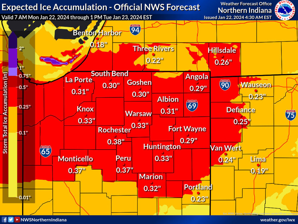
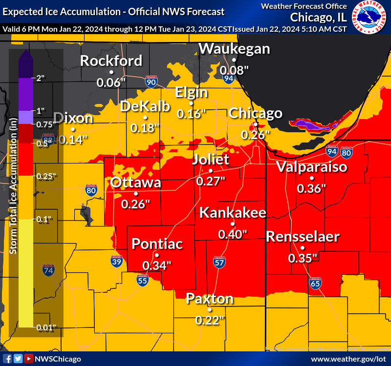
Wind results in more evaporative cooling, which translates to higher radial ice accretion that more strongly corresponds to true ice storm type impacts. Winds also bring down trees and powerlines. This case is less straightforward because of the lack of wind tonight. I can't speak to the decision process today yet, but if we don't upgrade, the lack of stronger wind will probably be a contributing factor.
-
1
-
3
-
-
We did get an all in storm total of 16" in Chesterton. It appears the heaviest last night was far enough west of the county line that there's a relative gap just west of where you are. Out of curiosity, if you drive through there, interested if it's around a foot in the Town of Pines/Beverly Shores area.Mostly in northern Laporte. Once we crossed into Porter county amounts quickly dropped to ~6”
Sent from my SM-G998U using Tapatalk
-
ORD is up to 16.1" (January normal is 11.3") on the month and 20" (normal to date 16.1") on the season, vs. 0.4" in January and 4.7" on the season as of 1/19/2023. We're in decent position to make a run at normal+ for the season, which is definitely a surprise.I mean its a Nino too, what do people expect? At this point take the wins as you can get them.
We've had consistent snow cover in the suburbs since January 5th. And I doubt we fully melt it out next week unless we get much higher dew points with how glaciated the bottom layer is. Seems possible we keep some snow depth through the end of the month.
Either way, the ORD snowfall data and this long of a stretch of snow cover and cold temps in a strong Niño has to be taken as a win, even though things could've gone even better than they did.
-
6
-
-
The EPS was not as bad as the GEFS in the extended, so considering the volatility in the LR guidance maybe it's not a done deal to be bad at the end of the month. Still would think more like mid February for anything resembling the pattern we've been in though.Grasping at straws I know but considering what's coming, the Euro has something nice at the end of it's run. I'll take it.
-
1
-
-
My post from several days ago doesn't look like it's going to age well. [mention=525]OHweather[/mention] can probably speak to this better but it appears there's going to be another Pacific jet extension event, paired with the MJO forecast to go into unfavorable phases.
So the favorable look that existed end of the month into February certainly isn't there on the ensembles anymore. That said, with the warmer stratosphere and resultant weakened SPV, the retraction of the Pac jet may eventually lead to another favorable window, aided by the MJO if it keeps moving along like it has been lately.
Relative to pre-season thinking for this winter, the stretch we've been in has been quite active and unexpected, up there with the winter 2020-21 rally though with the heaviest snows displaced west and northwest. It's not too surprising to get back into another unfavorable window amidst a strong Niño if things play out as they're looking at this point for late January into the start of February.-
3
-
1
-
 2
2
-
-
The 12z HREF LPMM is chef's kiss. Up to 2.08" QPF in northwest LaPorte, 1.25" in northeast Porter. The PMM 24 hour snow on the SPC HREF page is showing a spot of 30-33" associated with the highest LPMM QPF valid 00z tomorrow evening.
-
3
-
-
For those who have wanted to chase a Lake Ontario or Erie LES event, I think tonight-tomorrow's event for northeast Porter, especially LaPorte, and nearby is worth considering heading out. The high res guidance is in really good agreement in 1.5"+ QPF, so it's not just the HRRR putting out huge amounts of QPF. This could be one of the better southeast Lake Michigan LES events in a while.
-
2
-
-
I think while the HRRR is typically too aggressive and too far west, the 3km NAMnest can fairly decent for lake effect. The WRF-ARW and NSSL-WRF are worth a look too when they come into range, via Pivotal, Tropical Tidbits, or HREF page. Finally, the 2.5 km HRDPS (Canadian) may be worth a look when it comes into range, via WxBell or Tidbits.Are there any reliable CAMS that can be used to forecast the lake effect on Friday? It seems like all of the American suite are poorly regarded. It's two days out, so this is probably far too early to get into those specifics.
-
We have tomorrow evening-Thursday evening f-gen banding to contend with and then much of the guidance except for the GFS looks pretty interesting for high ratio fluff Thursday night into Friday morning with lake enhancement potential into NE IL and NW IN.
-
7
-
Winter 2023/24 Medium/Long Range Discussion
in Lakes/Ohio Valley
Posted
The early next week system gives some vibes of a potential northwest trender and a stronger system farther west. Just as a point of reference, the loading pattern looks somewhat reminiscent of GHD II, with a prominent ridge spike out west and positive height anomalies (good height rises) to the east.
There's been a decided trend the last few cycles of the GEFS of a stronger primary with better clustering near and west of the ensemble SLP mean.
Taking the 12z operational GFS, you'd want to slow down the main southern stream wave, which could allow for phasing with the northern stream short-wave to occur farther west.
[Edit: This isn't strictly a Chicagoland centric perspective. As things stand now with the 12z cycle there's enough support for a moderate event in portions of the subforum that have had very little snow this winter.]