

msuwx
-
Posts
648 -
Joined
-
Last visited
Content Type
Profiles
Blogs
Forums
American Weather
Media Demo
Store
Gallery
Posts posted by msuwx
-
-
Clearly seems to be beginning an ERC which will probably help the wind-aspect of this system for coastal Florida.
Also, if that is the case, could cause weakening once inland a little more quickly than expected.
-
 1
1
-
-
1 hour ago, PantherJustin said:
also, @msuwx do you have an archived vid "The Carolina wx video" ? i was a Sr in HS but remember your vid on March 2009 if im not mistaken
-
2
-
-
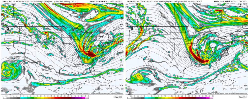
Biggest takeaway is that it came in way, way stronger at 500mb than the previous run. I mean a lot stronger.
Exactly how that closes off, and how the vort energy causes the ULL to wobble, to make a big difference for folks in the western Carolinas.
-
8
-
-
Stronger system, much more pronounced warm nose ahead of it at 60-63 hours.
ULL is much deeper at that point over MS/AL compared to 6z.
-
This (12z) NAM run looks like it will turn out fun.
-
4
-
-
Folks complaining about the overnight runs must not have been paying attention this winter. At least it's something.
-
12
-
-
8 hours ago, Grayman said:
Not happening . All rain on CMC and Gfs at 00z. It’s time for some hot dogs on the grill.
Not exactly correct.
-
1
-
-
The Euro took a big step west with the diving energy in the Plains compared to its 0z run.
Significant adjustment IMO.
0z:
.thumb.png.0bd2d4839f1590c9e037fd9c89ec0211.png)
12z:
.thumb.png.00cedc6b7573aee92565767bb27b28bc.png)
-
4
-
 2
2
-
-
3 hours ago, GaWx said:
Whereas the 0Z GEFS backed down on a coastal 12/26 threat, the 0Z Euro did the opposite. It had at 240 in the SE Gulf a weak low that appeared ready to make a turn NE across FL and strengthen. This would be due to the 500 mb flow becoming a more moist SW in response to strong upper level energy diving SE from Canada. Cold enough air at the time was still along the coast. Had this run gone just a little bit further, I think it would have shown a coastal SE winter storm.
More importantly, the 0Z EPS supports the Euro with a good number of members as well as the mean looking threatening on 12/26. In addition, 8 of 20 (40%) of 0Z GEPS members have wintry precip, mainly ZR, to the coast on 12/25.
Edit: 6Z GFS is MUCH warmer on 12/26 with no winter storm anywhere closeby, following the lead of the 0Z GEFS.
6z GFS is definitely still a hit of snow for a lot of the region.
.thumb.png.cb66176a47524ab8c2b42e7b87196351.png)
But yes, it is a later, further east phase/ digging.... not what most would want.
6z compared to 0z:
-
5
-
-
I can tell you from talking personally to someone this morning in Cape Coral.... they are staying but have a 'go' bag ready. I tried to tell them when the surge comes in, it will come quickly and it will then be too late.
-
6
-
3
-
-
I have not dug deeply into the longer range this morning, but when I did yesterday, I saw nothing at all that signaled an end to winter anytime soon.
-
11
-
 3
3
-
-
35 minutes ago, WxKnurd said:
I think it was the ‘14 storm, @BullCityWx was reporting huge flakes just piling up down in Ft Mill and there I was sitting a couple degrees colder yet all I have was a mighty blizzard of pea sized at best flakes. Same storm, same precip shield, just was stuck with what had to be lackluster moisture transport in the dendrite growth zone. Then it switched to sleet and we had 4” on concrete and a local minima I think. The Belmont/Mt Holly/Western Meck below Mountain Island earned that surprise overperformer the other week!
That was it!
And yes they did.... that areas has had it rough!
-
25 minutes ago, WxKnurd said:
So true, when I lived over by the airport on the river we kept getting shafted with either terrible moisture in the dendrite growth region or the dreaded warm nose.
I still have painful memories of an event a few years ago. Looked good for a big Charlotte snow.... went to dinner and huge flakes were flying. Felt good about my forecast. Walked out of dinner to head to the hotel..... and sleet was falling. Knew it was over then.
That's the event that I vowed to never take the NAM's warm nose projections lightly.
-
2
-
-
5 minutes ago, eyewall said:
Congrats all from the screw zone. What a joke this ended up being here.
Prior to this winter, I don't think there has been a more prolific screwzone in the region than the Charlotte metro....especially western and southern Charlotte metro. It's nice to finally see that reversed a bit.
-
1
-
-
Say what you will, having 3 winter weather events, to some degree, in 20 days is very impressive to me. Some spots in western NC had snow on snow on snow, which is pretty dang rare (I've never experienced it personally before), outside of the higher mountain spots.
-
11
-
-
23 minutes ago, Brick Tamland said:
Well, they canceled the basketball games for tomorrow. We better get at least 2 inches out of this.
You should try on for size the volume of high school basketball games we’ve had to cancel this month.
-
1
-
-
26 minutes ago, PantherJustin said:
Ik you can’t speak for anyone but you… but Think GSP thinks even with limited QPF in general what we do see we will waste trying to get to 30-32? (CLT Metro) . I could see that outcome leaving us high n dry more than it just never occurs but I’m not an expert by any means
I think there’s just more uncertainty than normal that that snow band will set up and exactly where it will. Probably better to play it very conservative and ramp-up than the other way around.
could be one of those things where a lot of the accumulations that do occur or mainly on the grassy and elevated surfaces with it taking a while for the surface temperatures to cool. Then again, if this band performs well with rates as some previous setups have done, that won’t matter much.
-
4
-
-
This one is quite vexing because of the lack of support for the UL-induced band with the RGEM and NAM.
I still feel fairly confident it happens….but what a low confidence forecast.
-
4
-
1
-
-
1 minute ago, TARHEELPROGRAMMER88 said:
NAM is now hundreds of miles east with the low
That's some random other little low that developed by hour 57. Not the main low. The main upper forcing is just arriving.
-
1
-
-
1 minute ago, strongwxnc said:
Thanks Matt. Looks like if that was came true, we would be looking at dusting here in the southern foothills.
Yeah a lot of the modeling is consolidating around the idea of that nice band of snow/ snow showers working through western and central NC.
Entirely dependent on upper levels though, so time will tell.
-
2
-
-
-
Although it could be, are we really going with “last hurrah” in January?
-
11
-
 1
1
-
-
Looking at 500mb vort….the Canadian was really, really close to a biggie.
-
9
-
-
1 minute ago, PantherJustin said:
I’ve wondered as a Met hypothetical here obviously….. should that still be showing Weds eve…. What would be max a producer would allow you to say on tv amount wise? Or is that not a thing like I think lol
Haha. It’s not a thing. Nobody tells us what to say or not say. Our management trusts us to lead the coverage as we deem it appropriate.
-
4
-
.png.70f059a481e120f1ff61396d2c796ee5.png)
.png.c4860439128efcb8dfd101f127cea2b0.png)
.png.05cb24c7425fc45b46b83a3b72713c22.png)
.png.657a76f8c88939569ff34185c1345023.png)
Mid to Long Range Discussion ~ 2024
in Southeastern States
Posted
Writing off 21 days with tons of arctic air in the pattern is an interesting position.