

msuwx
-
Posts
673 -
Joined
-
Last visited
Content Type
Profiles
Blogs
Forums
American Weather
Media Demo
Store
Gallery
Posts posted by msuwx
-
-
2 hours ago, Jwisephoto said:
6z gfs looks dry.
??
-
 3
3
-
-
1 minute ago, wncsnow said:
Not until we lose 13 straight first
I think we’ve lost about 37 straight....
-
4
-
 2
2
-
-
1 minute ago, Wow said:
Temp and DP actually went up in the past hour by a degree. 41.7/28.9. Going to need to sit in a heavy band to drop these sfc temps if anything it going to accumulate.
Yeah the wet bulb will probably remain above freezing in CLT throughout the precip time-frame. Going to take some great rates to overcome the 'warm-ish' boundary layer enough to accumulate.
I'm not crazy about the overall look from CLT-GSP, but we will see. Radar looks good though.
-
1
-
 1
1
-
-
Still looks like a significant NC hit is on the way at 45 hours. We will see.
-
6
-
 1
1
-
-
1 minute ago, TARHEELPROGRAMMER88 said:
Anyone have the EPS?
Similar to 6z. Couple of tenths less.
-
1
-
 1
1
-
-
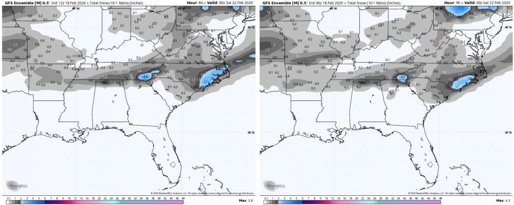
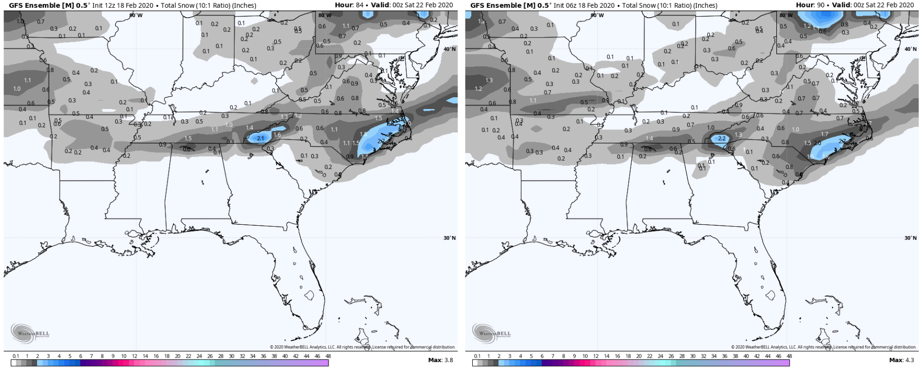
12z GEFS snowfall mean vs. 6z:
-
2
-
-
6 minutes ago, BullCityWx said:
Matt, for the life of me, I can’t figure out how people are complaining about this run if you’re almost anywhere north of 74 in NC. What do they want?
I don't either. Personally, give me a moisture-packed system over one where people are hoping the light precip is heavy enough.
-
4
-
-
3km snapshot vs 12km NAM snapshot at the heart of the event. Very similar, and I would not pay a ton of attention to the PType algorithms near the transition line.
-
4
-
-
22 minutes ago, SnowDawg said:
The 6z Euro was not drier than the 0z run. Definitely still drier than other models, but the main/control/mean all bumped slightly north with QPF. It just spent over a whole day going back and forth with every single run.
Exactly. This narrative that the 6z Euro was drier than the 0z is false.
3 minutes ago, TARHEELPROGRAMMER88 said:Never bet against the ECMWF. NAM and other models appear to be caving slowly to ECMWF and UKMET. IMHO
Watching the 12z NAM now, but through prior runs, this is not correct. The Euro has shifted toward the NAM, not the other way around.
-
5
-
2
-
-
Just now, SnowDawg said:
My 2 inch soil temp on Feb 7th was 43.7 and 55.5 on the 6th.
Thanks. How much did you pick up?
-
Before that argument begins, can one of you north Georgia or Upstate SC folks pull up and post soil temps prior to our Saturday event a week or so ago?
-
3
-
1
-
1
-
-
2 minutes ago, BornAgain13 said:
How does the 18z EURO and EPS Look?
Not out yet.
-
On the 12z Canadian, there's much less upper level (500mb) dynamics involved because of the handling of the vort moving out of the Rockies into the Plains Thursday morning. 0z GEM kept it rolling southeast and there was a degree of phasing of the system, leading to the NW side of our coastal low blossoming with precip.
12z GEM takes the Rockies vort to the ENE (rather odd-looking) and you get little to no interaction with it and our coastal system.
-
3
-
1
-
-
I really like the odds of a nice, west-east oriented area of overrunning snow with this system. The setup is ripe for that, assuming we get decent precip rates. The air aloft is plenty cold for snow, and only gets colder as the event unfolds.
The question is will the band with the right balance of cold air/ precipitation overlap to generate snow be in northern SC, southeastern NC, further north, or will precip remain too light to really generate any accumulating snow in most places.
Too soon to know.
-
14
-
-
15 minutes ago, mackerel_sky said:
Doesn’t the GFS have a bias for holding energy back too long? I thought that was a thing? I don’t know how anything holds back in such a fast flow, just got to get timing right!
That’s the old Euro bias.
-
Pet peeve alert....
This is largely a board for weather enthusiasts. It gets very old when the flood of the same, tired, snide comments come in after someone posts a medium-range model map. I think everyone reading this board is aware a single run of a deterministic model (or single ensemble member) will likely never verify in the extended medium range.
But what are people supposed to post? A picture of an overcast sky? The purpose of the board is to discuss whatever there is to discuss, and unfortunately for snow fans, medium-range snapshots are about all we've got.
End of rant... back to your regularly-scheduled programming.
-
21
-
6
-
-
3 hours ago, Iceagewhereartthou said:
Except most of those winters took place before 2010, you know, when it actually got cold every now and then. Most of us haven't even had a close call yet. Not to mention we're well past 1/15 and it's not looking good. Still, theres hope.
1 hour ago, StantonParkHoya said:The coldest week in history for a large swath of NC occurred in the last 3 years.
The 'it doesn't get cold anymore' narrative gets tiresome.
-
1
-
3
-
-
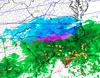
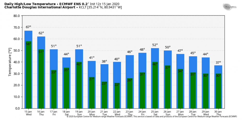
12z EPS for KCLT
-
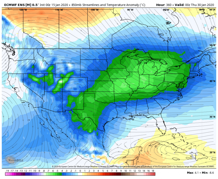
Just now, wncsnow said:
Yea, the cold comes back maybe by hour 360. What could go wrong?
That’s 4.5 days after the map you posted. So yes, that’s pretty quick rebuilding of the cold.
But we will see....
-
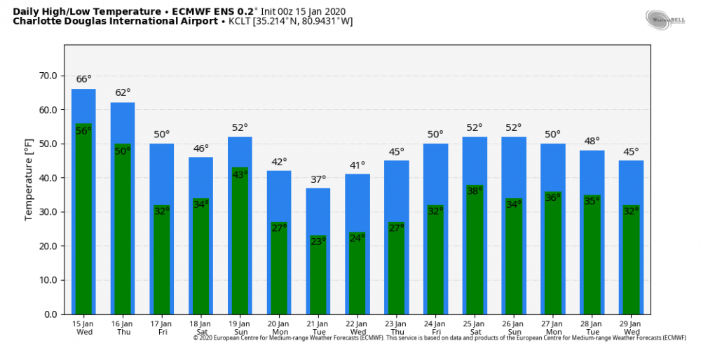
2 minutes ago, wncsnow said:
Day 10 of the Euro certainly doesn't look like the cold is rebuilding quickly..

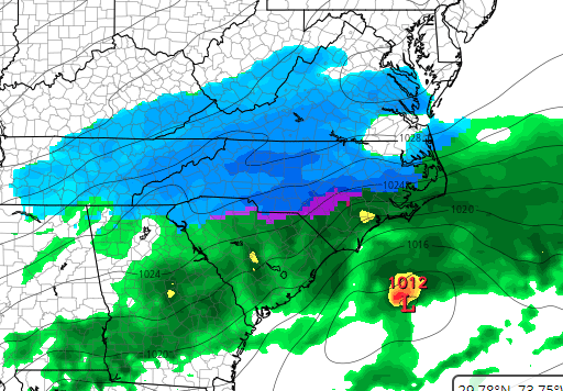
Last frame of the 0z EPS
-
20 minutes ago, wncsnow said:
You can have your GFS, I will take my EPS and Op Euro thanks.
Even taking the 0z EPS at face value, that is nothing that resembles ‘warm.’
-
2
-
-
2 hours ago, mackerel_sky said:
The blockbuster pattern that was showing up a few days ago, for cold and wintry weather, has turned to cool shots, followed by rain. Rinse, repeat
That is not even remotely correct.
-
11
-
3
-
-
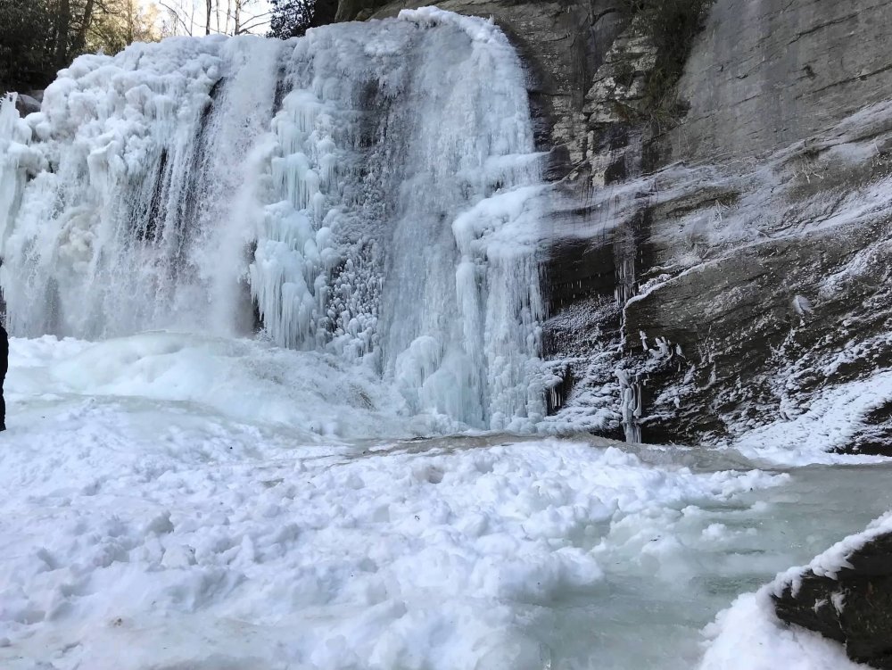
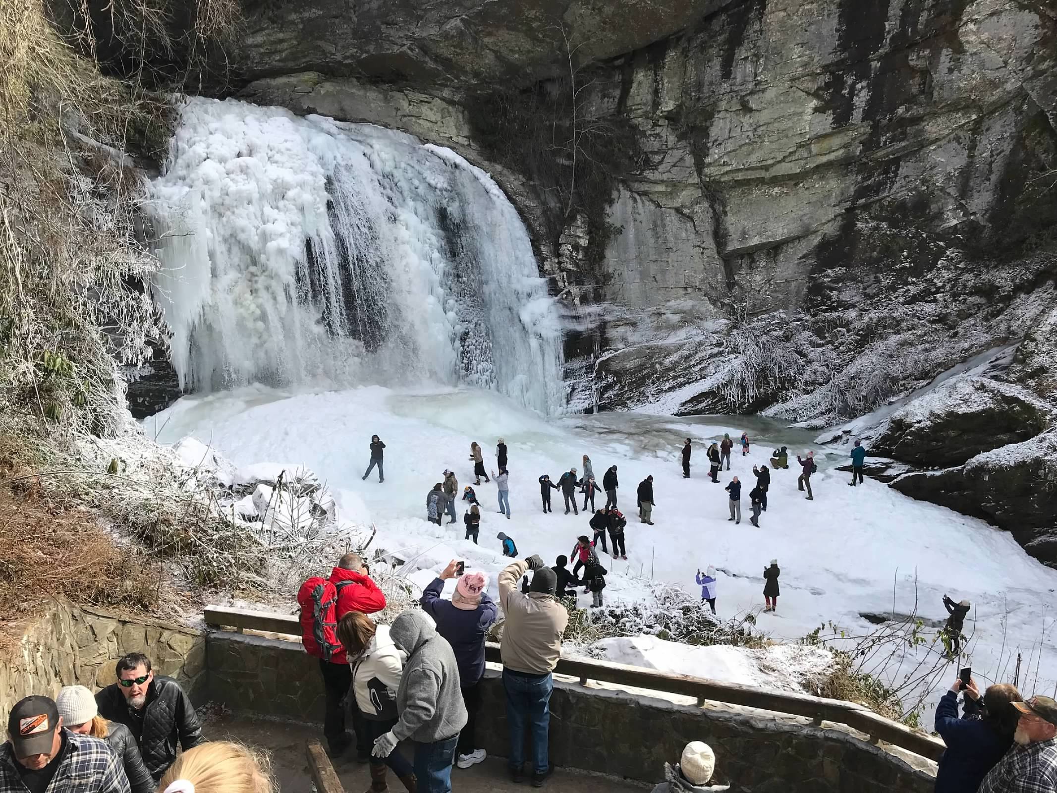
21 minutes ago, StantonParkHoya said:
Raleigh got 15.6 inches of snow last year and in January 2018, RDU spent a record 159 hours below freezing. Lakes and ponds throughout the state were frozen so thick, ice-skating was rampant.
I get what you're saying, but don't let recency bias turn into hyperbole. This is just a crap pattern.
Yep..... Looking Glass Falls in January 2018.
.thumb.jpg.e0e3bc3c46ca96f00e7442b623aa34ca.jpg)

-
7
-
-
EPS is very noisy.... tons of variance in the placement/ strength/ timing of the 500mb feature. 500mb spaghetti looks like..... well, spaghetti.... across the Southeast 12/22-23.
-
3
-


.jpg.14c72c7e491f9c19374694992fb53018.jpg)
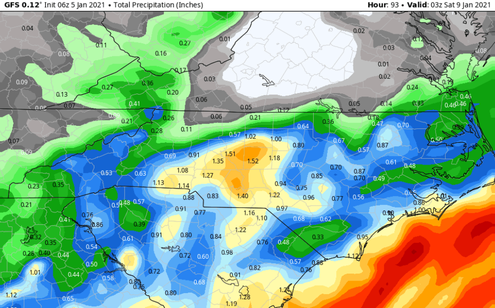
January 8th-9th threat
in Southeastern States
Posted
While it isn't as aggressive as some other models, the 6z GFS actually beefed up the snow totals in much of NC compared to its 0z run.
See the comparison below: