Jump to content

Anduril

Members
  • Posts

    816
  • Joined

  • Last visited

Everything posted by Anduril

  1. Certainly didnt look like we got much of anything. Grass was barely wet. The past 10-15mins we had a bit steadier rain but not much else besides some nice rumbles of thunder
  2. Pretty sure I remember seeing one of the Mets in our area on twitter yesterday saying it was on pace to be the hottest. Of course now i cant find it
  3. Meso discussion for us is out Aforementioned strong surface heating will allow for the development of steep low level lapse rates, and some mixing of the boundary layer. As such, this will enhance strong downburst potential, and clusters of damaging wind are likely. Some guidance suggests a bowing segment or two could develop out of these thunderstorm clusters through outflow/storm-scale interactions/mergers or smaller-scale cold pool development. If this occurs, any forward-propagating bowing segment could increase the damaging wind threat locally.
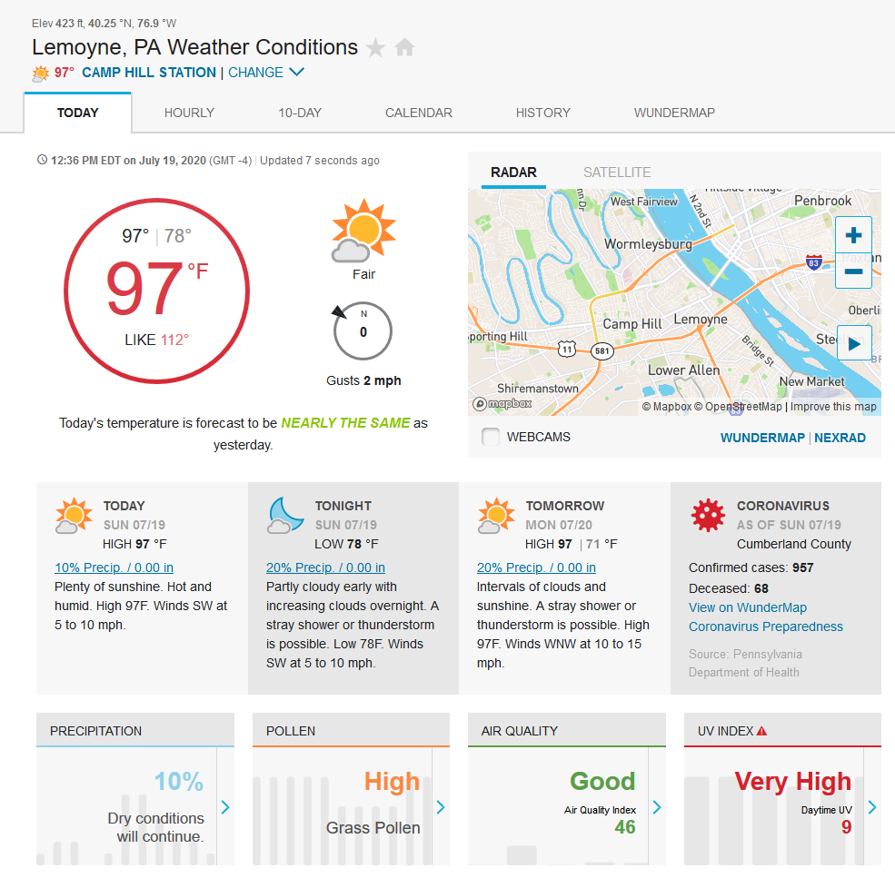
  4. I know the accuracy of many of these stations are questionable but...its hot yo
  5. And now its raining buckets. I really need to get a weather station/gauge cause this is some damn heavy rain rates and from the pingers sounding there might be some real small hail mixed in
  6. Im pretty sure the line entirely missed me here in Camp Hill...lol
  7. Man you'd think with that ULL just spinning over WV and the humid ass air mass its pulled in we'd be seeing storms popping left and right but they just die when they hit the border of s central PA lol
  8. Who the hell still downloads winrar these days?!? lol
  9. And just like that all the storms are gone and wrecking lancaster/reading. totally weird
  10. Welp def raining in camp hill area now lol
  11. Yea this has been a really weird event/forecast
  12. I doubt we'll get any big thunderstorms like yesterday but I can def see some slow, heavy rain type storms. Its just dripping outside
  13. Franklin-Perry-Dauphin-Schuylkill-Lebanon-Cumberland-Adams-York- Lancaster- Including the cities of Chambersburg, Newport, Harrisburg, Hershey, Pottsville, Lebanon, Carlisle, Gettysburg, York, and Lancaster 1038 AM EDT Fri Jun 5 2020 ...FLASH FLOOD WATCH IN EFFECT FROM 2 PM EDT THIS AFTERNOON THROUGH THIS EVENING... The National Weather Service in State College has issued a * Flash Flood Watch for a portion of central Pennsylvania, including the following areas, Adams, Cumberland, Dauphin, Franklin, Lancaster, Lebanon, Perry, Schuylkill, and York. Guess it would have helped to post the whole thing whoops
  14. Flash Flood watch issued From 2 PM EDT this afternoon through this evening * Heavy showers and thunderstorms training over the same locations this afternoon and evening could bring up to a few inches of rain in less than one hour, leading to localized flash flooding of small streams and poor drainage areas. Just what I need more water for in my basement lol
  15. I dunno man from what you've said before...you *def* dont like getting *slammed* :p
  16. Yuppers. And it wasnt much hail but I saw some other reports show up as well on Radarscope
  17. Carlisle got smacked pretty hard with the cell around 742p I even reported hail to mPing
×
×
  • Create New...