

southmdwatcher
-
Posts
934 -
Joined
-
Last visited
Content Type
Profiles
Blogs
Forums
American Weather
Media Demo
Store
Gallery
Posts posted by southmdwatcher
-
-
I have GRLevel2 Analyst 3.0 and the Tarrant storm doesn't yet look dangerous, as per a producing tornado issue.
-
-
Rain and 46 degrees. Beautiful for early October.
-
 1
1
-
-
Tornado warning for the storm crossing the river into Charles County.
-
14 minutes ago, midatlanticweather said:
Can you all se this? May be private - Great time lapse of the storm near Culpepper from a friend of mine. May have to capture the video to share.
https://www.facebook.com/100000582945845/videos/5348130565294193/
Video might be private or only available to his friends. Can not see it.
-
 1
1
-
-
The storm near Culpeper needs to be watched. Now severe warned.
-
Radar is aiming this first batch crossing the mountains toward southern MD/Northern Neck area.
-
So this is going to be a southern MD/central VA event??.......well at least most of us have relatively dry ground
-
3 to 5 inch plus jackpots along Sligo Creek and the Little Patuxent River would be problematic
-
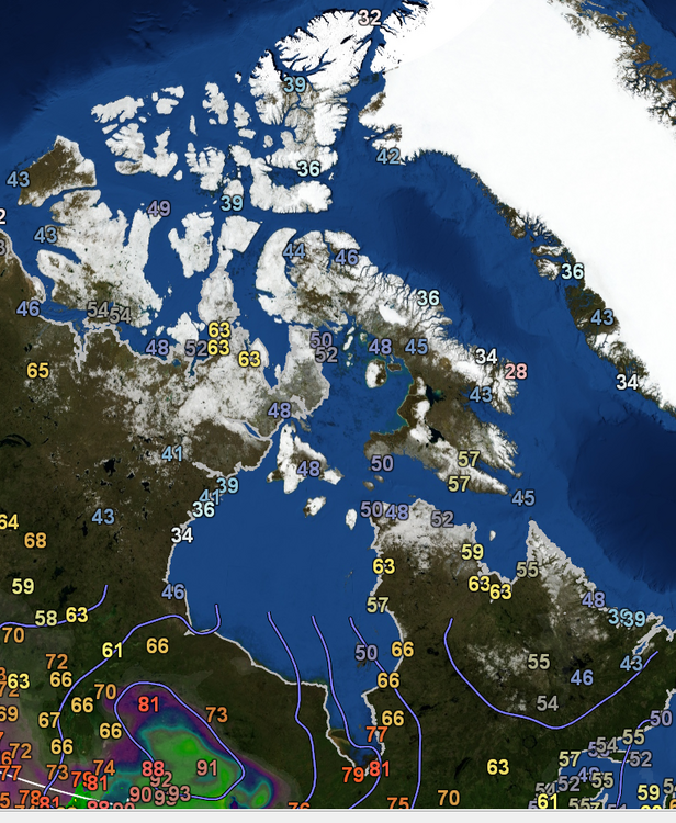
As per GR Earth the current temperatures in Central and Northern Canada
-
2
-
-
Central PA supercell with the tornado warning has a BWER
-
We might be too far north or east to receive the storms forming out in Ohio and West Virginia. However, at least one of yesterday's SPC Convective outlook discussions, mentioned that the shortwave coming out of the Ohio Valley today and crossing over the Appalachians would produce some strong to severe storms well into the night for some portion of the Mid Atlantic region. Probably going to be a Richmond target.
-
St Mary's storm now popped above 50k ft
-
St Mary's supercell has strong mid level rotation
-
Severe Weather Statement
National Weather Service Baltimore MD/Washington DC
806 PM EDT Fri May 27 2022VAC099-280015-
/O.CON.KLWX.TO.W.0020.000000T0000Z-220528T0015Z/
King George VA-
806 PM EDT Fri May 27 2022...A TORNADO WARNING REMAINS IN EFFECT UNTIL 815 PM EDT FOR
NORTHEASTERN KING GEORGE COUNTY...
At 806 PM EDT, Doppler weather radar indicated a tornado was located
over Dahlgren, moving northeast at 30 mph.HAZARD...Damaging tornado and quarter size hail.
SOURCE...Emergency management confirmed tornado.
IMPACT...For those in the direct path of a tornado touchdown, flying
debris will be dangerous to those caught without shelter.
Damage to roofs, siding, and windows may occur. Mobile
homes may be damaged or destroyed. Tree damage is likely.Locations impacted include...
Dahlgren and Nanjemoy Creek. -
And we have breaks in the clouds and some sunshine breaking through sporadically.
-
A completely destroyed house as per the Bedford VA scanner. Definitely significant damage to more than one home.
Bedford County Sheriff, Fire and EMS, Bedford Police Dispatch Live Audio Feed (broadcastify.com)
-
2
-
-
So, if the 12z NAM 3km is correct about the DC/Baltimore/Fredericksburg area having 1800 to 2500 MLCAPE this region will have some instances of significant severe weather tomorrow. The 300 to 700mb flow is focused towards our area during mid to late afternoon tomorrow.
-
Day 2 Convective Outlook
   NWS Storm Prediction Center Norman OK
   1218 PM CDT Sun May 15 2022

   Valid 161200Z - 171200Z

   ...THERE IS AN ENHANCED RISK OF SEVERE THUNDERSTORMS FROM NORTHERN
   VIRGINIA INTO NEW YORK...

   ...SUMMARY...
   Scattered severe storms are expected Monday from central New
   York/western New England southward into the Carolinas. Damaging
   winds, hail, and few tornadoes will be possible through about 00Z.

   ...Synopsis...
   A shortwave trough will move quickly from the OH Valley toward the
   Mid Atlantic during the day, taking on a negative tilt across New
   England after 00Z. Deep-layer wind fields will strengthen with this
   trough, with substantial large-scale ascent from VA into NY.

   A surface trough will deepen as it moves into eastern NY and PA,
   with dewpoints holding near 60 F within the zone of convergence.
   Farther south, the main cold front push will occur from MD into VA,
   coincident with a midlevel dry slot. Here, dewpoints around 65 F
   will be more common, with a plume of steep low-level lapse rates
   emanating out of the southwest.

   ...Northeast and Mid Atlantic into the Carolinas...
   Thunderstorms will likely be ongoing Monday morning from western PA
   into WV along the developing cold front, and SBCIN will likely be
   removed by 15Z due to cool 700 mb temperatures. Storms are expected
   to become severe between 15-18Z as they develop into south-central
   NY, central PA, and toward far northern VA. MLCAPE is expected to
   average 1000-1500 J/kg, with effective deep-layer shear of 40-50 kt.
   Mixed storm modes may occur, including supercells and QLCS. Damaging
   wind gusts will be most likely. The tornado threat is expected to
   increase during the late afternoon as the surface low/trough
   deepens, low-level lapse rates are maximized, and effective SRH
   increases to around 200 m2/s2. Cool temperatures aloft and elongated
   hodographs will also favor sporadic hail in the stronger cells.

   Although shear will be weaker farther south into the Carolinas,
   strong heating and plentiful moisture will result in 2000 J/kg
   MUCAPE with sufficient westerly shear to support multicells with
   wind and hail threat. A few cells may linger toward 00-02Z.
-
The enhanced area definitely expanded a bit to the west and south.
-
Wasn't April 28. 2002 also a moderate risk for the LaPlata tornado???? Unfortunately SPC is too happy to erase their files now beyond a certain timeframe.
-
Southwest VA down through western NC and upper SC are overperforming this evening with severe storms. The warm front is north of Richmond now.
-
Large TDS and debris ball east of Gilmer TX
-
1
-
-
Crockett has a large tornado nearby and a BWER near Gilmer TX

Major November Outbreak Possible
in Central/Western States
Posted
However, that storm looks to be splitting.