

Mr. Windcredible!
-
Posts
2,962 -
Joined
-
Last visited
Content Type
Profiles
Blogs
Forums
American Weather
Media Demo
Store
Gallery
Posts posted by Mr. Windcredible!
-
-
5 minutes ago, The 4 Seasons said:
really? there is a 5" report from Clinton at 210PM but might have been more inland you must be right at the beach?
I'm a few miles inland. But another mile or two NW could've been all it took to grab another couple inches. Maybe if someone was using a snowboard and cleared it mid-way...that could've helped too. But I never went above 3" on any surface I tried measuring on.
-
 1
1
-
-
Only 3" here near the shoreline. Torched BL really killed us. Not really terribly surprising...but still disappointing. Over 2 years (1/29/22) since last warning event and counting. At least this one put us over last year's pitiful season total.
-
 1
1
-
-
Measured 2.3" here this morning and got a quick walk in before the changeover. It's been freezing drizzle since 9am. Temp has crept up to 29.5F. Rumor is roads are quite slick, so no school was the right call. Expect to flirt with freezing before temps drop again later this afternoon.
-
1
-
-
5 hours ago, Sey-Mour Snow said:
CT knows how to jack rainfall .. unreal .. another 1.5 to 2.5" likley with iso 3 in the favored rainforests
It's absolutely ridiculous. And the models seem to have no problem nailing it 5-days out. Yet if there's snow involved...models can't even get it right within 12 hours. We're a magnet for heavy rains but repel snows like we're the new Mid-Atlantic.
-
4
-
-
3 minutes ago, Typhoon Tip said:
I was just gonna comment on that -
COD appears to have changed their algorithm. Particularly in the lower levels - I'm not sure that is intended or if that is an artifact of a 'bug' in the rendering, but I kind of like it. If studying the loop of that image, you can clearly tell by behavior that is highlighting the RH fields trapped below some 900 or so mb inversion. Pretty cool ...
I also came just to see if anyone had commented on the satellite presentation this morning. I don't recall ever being able to see multiple distinct stratus layers in visible imagery like that before.
-
We were supposed to leave first thing in the morning tomorrow to go to PA to visit my son at college. Just called an audible about an hour ago and let my wife know we needed to leave tonight or risk driving thru flooding rains or canceling altogether, neither of which was going to be an acceptable option. So plan is to make it to her sister's in W NJ tonight to get us to the other side of this incoming firehose.
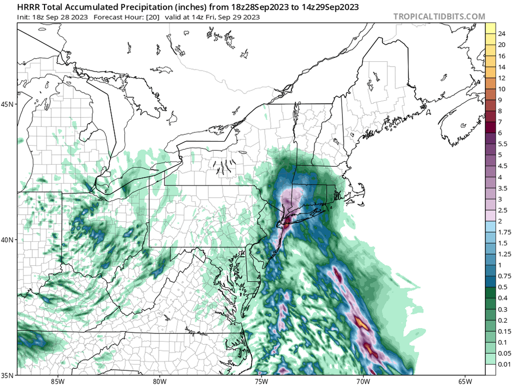
2 minutes ago, binbisso said:This would be awful tomorrow morning for the am commute. Latest hrrr. This is only through 9 AM tomorrow morning.
-
5
-
-
4 minutes ago, WinterWolf said:
Nope…still can’t. No biggy.
I think it's just you. It's just the Euro Op totals. No crazy 6-12" totals...but a widespread 2-4" for most of the region.
-
 2
2
-
-
28 minutes ago, WinterWolf said:
Interesting set up coming together. Post your thoughts here gentlemen.
I was thinking maybe if we just ignore it, it will go away.
-
 1
1
-
-
10 minutes ago, Sn0waddict said:
This doesn’t look great.
My anxiety is through the roof. Gonna be away for the weekend and don't want to come home to a wet basement. Even though we had french drains put in back in May, I'm still nervous about water finding it's way in through other small cracks in the foundation.
-
did briefly hit 90 an hour or two ago. First 90 degree reading of the year here.
-
2
-
-
I feel like we’ve done that a lot lately up north too… gets real hot in like April or May with 90+ prior to full leaf out. Then summer is meh for max temps but we’ll run 90+ in September again.
Yeah…I mean the early September heat/humidity is certainly not unusual down here. You can almost predict it by the school calendar…first or second week back there’s always a few uncomfortable days in there somewhere.
But having our hottest day of the year in mid-April is unheard of along the CT shoreline, given LI Sound temps that time of year and the ease at which the sea breeze penetrates inland. I’m a few miles inland, but typically April temps at BDL in the 80s that time of year means a low-70s high at noon and temps falling into the low 60s by 4-5pm with a chilly breeze. So if that April high stands as our warmest day it’s will a bit of an anomaly. But we still have a couple more days here with a shot to crack 90, so we’ll see.-
1
-
-
Have yet to hit 90 on the PWS so far this year. But today was my 2nd warmest reading of the year (88.7F), just behind the 89.1F high I had back on...April 14

There's a decent chance that come the end of the week, 4 of the 5 hottest days of the year here will have fallen outside of meteorological summer
-
2
-
1
-
-
2 hours ago, Hoth said:
Oof. Goddam brutal here verbatim. Feels like one of those events where the northwest hills of Hamden pull 4” and I’m watching mangled cat paws melt on contact.
I feel your pain. I'm a couple miles inland but it's usually not enough in marginal situations...whereas Killingworth/North Madision/North Guilford can pull off an inch or two. Hell, it's infuriating how often parts of LI outperforms me...just happened with the event last week.
-
1
-
-
So desperate for any accumulating snowfall here that I slant-sticked my way to 0.1" on the patio table this morning. Refused to record the second biggest event of the season as a trace. It was all gone within an hour...but hopefully a 0.1" refresher headed our way tonight

-
Good Lord there's a lot of melts this morning for something 7 days out. I think some of you need to step away from your screens for the weekend and check back in Monday or Tuesday. If things look better by then you'll be refreshed for a few days of non-stop tracking...if it looks like shit, you can take comfort in the fact that you didn't waste your weekend away tracking it. And nobody here will have to listen to your whining. That's a win-win-win.
-
10
-
3
-
-
1 minute ago, Ginx snewx said:
We get at least one of these runs a year.

One every couple of days if you use the CMC
-
nearly perfect textbook run 8.5 days out. what could go wrong?
-
5
-
-
Here's to hoping we don't need a bigger boat for this one, but rather a bigger shovel
-
1
-
4
-
-
1.2" was the total here along the shoreline. Guidance seemed pretty accurate around these parts.
-
Ridiculous amount of lightning and thunder from this storm crashing through Old Lyme right now.
Yeah this is crazy and unexpected. Been going on for over 2 hours here in Clinton with only a brief lull. One of the most intense lightning storms I can remember here. Not much sleep happening in the house tonight.-
2
-
-
1 minute ago, Sey-Mour Snow said:
Holy sht. 93/79 for a 110 heat index at my house and the stations around me up to 113. Hottest indices since 2019.
91.2/79.6/108.9 here. May be on my way to an all time record high at my station. Caveat being this is only the 3rd summer of having it installed. Have not yet eclipsed 93.
-
1
-
-
30 minutes ago, weatherwiz said:
Nice mid level meso on that storm near Clinton
If that moved through an hour or two later I would've made a drive down to the water. Maybe would've seen some nice lightning over the sound if nothing else.
Here at the house it's just been some occasional rumbles of thunder the past couple hours...but have managed to pick up 0.20".
-
1
-
-
14 minutes ago, dendrite said:
Big dews south of Pike.
79.9 on my home station
-
10 minutes ago, Cyclone-68 said:
That same T-storm in Long Island sound seems like it’s been sitting there for hours
Have had some rumblings of thunder here the past couple of hours but the stuff over LI has had no interest in moving inland. Still have managed to pick up 0.35" though.
-
1
-


Following a Miller A/B hybrid type coastal potential, Feb 13th ... As yet untapped potential and a higher ceiling with this one
in New England
Posted
yeah I was surprised by that too. For many years I thought as long as you were west of the river along the shoreline things tended to work out pretty good in marginal situations. Last few years have been rough though, definitely have become a snow hole just like NL county. Watching the radar, seemed the best banding pushed just north of here after 7:30am or so...and we lost a couple critical hours. By the time we got back into some decent returns temp was up to 32.7 and it was all over. Crazy that literally a degree colder and it could've been a completely different story here it terms of totals. Seeing CC verify warning criteria also stings.