

codfishsnowman
-
Posts
5,066 -
Joined
-
Last visited
Content Type
Profiles
Blogs
Forums
American Weather
Media Demo
Store
Gallery
Posts posted by codfishsnowman
-
-
Omg its so humid out....I think we're gonna hit 90 at CEF
-
1 minute ago, ineedsnow said:
models look meh on heat except for a few days the next two weeks..
Well you're not in a great heat spot. I bet we hit 90 a bunch of times down here on your old turf
-
 1
1
-
-
43 minutes ago, weatherwiz said:
Not too shabby for SNE
-
1
-
-
Some Thunder....the meat of this will sail by just to our south for now
-
1
-
-
16 hours ago, FXWX said:
Never heard of any; yellow perch my have the upper hand now...
So it has become a great place for ice fishing then between the perch and bluegill...well thanks for responding. Some great memories there some 40 years ago.
-
1
-
-
19 hours ago, FXWX said:
Yes... it has always been a bluegill hot spot...
We got a few bass, pickerel, yellow perch and good size American Eels but never any bullheads. Do you know if it ever produced those?
-
39 minutes ago, FXWX said:
Actually not, surprisingly... On the Lake Grada side of town close to the Unionville line...
I used to love fishing Lake Garda when I was a kid. Big bluegills and lots of them. Used to go with my buddy Jimmy Johnson and then we'd clean em up and cook em on the grill.
-
1
-
 1
1
-
-
1 hour ago, dendrite said:
That song was so massive that year. I think it sold almost 4 million copies!! Back when one had to go to the store to buy music
-
Some crazy thunder last night and some rain but I don't think there was a ton. Still didn't expect anything. Kevin nailed the humidity though which was miserable all day and all night and still lingers a bit this morning.
-
1
-
 1
1
-
-
1 hour ago, dryslot said:
Ha
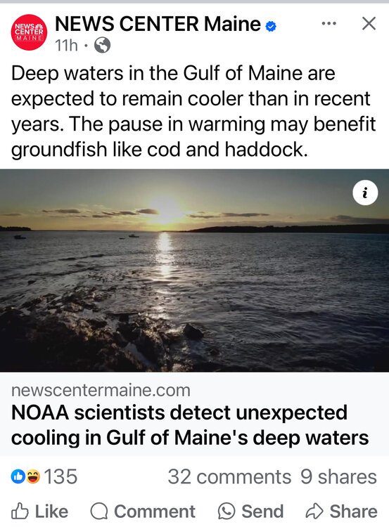
The cod and haddock need so much help. Especially the cod. Ii never thought I would be glad to see it shut down. To think of what once was all the way down to the Virginia Capes in winter and year round to the deeper waters off NJ is mind boggling.
-
1
-
-
Cannot wait for cooler next week....I hope its so cool there's wet snow above 2k if we get the noreaster or scattered frost at night in the valleys if its fair. I've had enough heat and humidity already.
-
 1
1
-
 2
2
-
 1
1
-
1
-
-
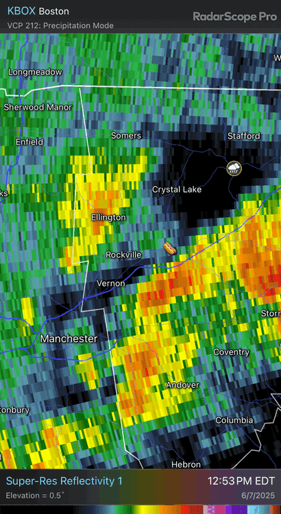
Omg the radar over RI and SE CT.....if only it would snow like that in those places more often ...I swear RI really knows how to do rain
-
1
-
-
1 hour ago, CoastalWx said:
Man summer is here. Feels good.
They had some good songs...Loved If I had no loot.
-
1
-
-
5 hours ago, Snowedin said:
Every friggin year, like clockwork! The zone of suck never fails to disappoint in coastal New England. Somewhere deep in the archives of Mayan mythology lies an entire book on this disturbingly predictable phenomenon that seems to occur with such regularity and precision that one could almost tune their half naked daily walks in the yard to its expected arrival!
While someone someday probably in the not too distant yearly future is snowed in for weeks with feet and feet of snow in the zone of suck. Can't have it all.
-
2 minutes ago, ineedsnow said:

The number #1 reason NOT to move to Australia.
-
1
-
1
-
-
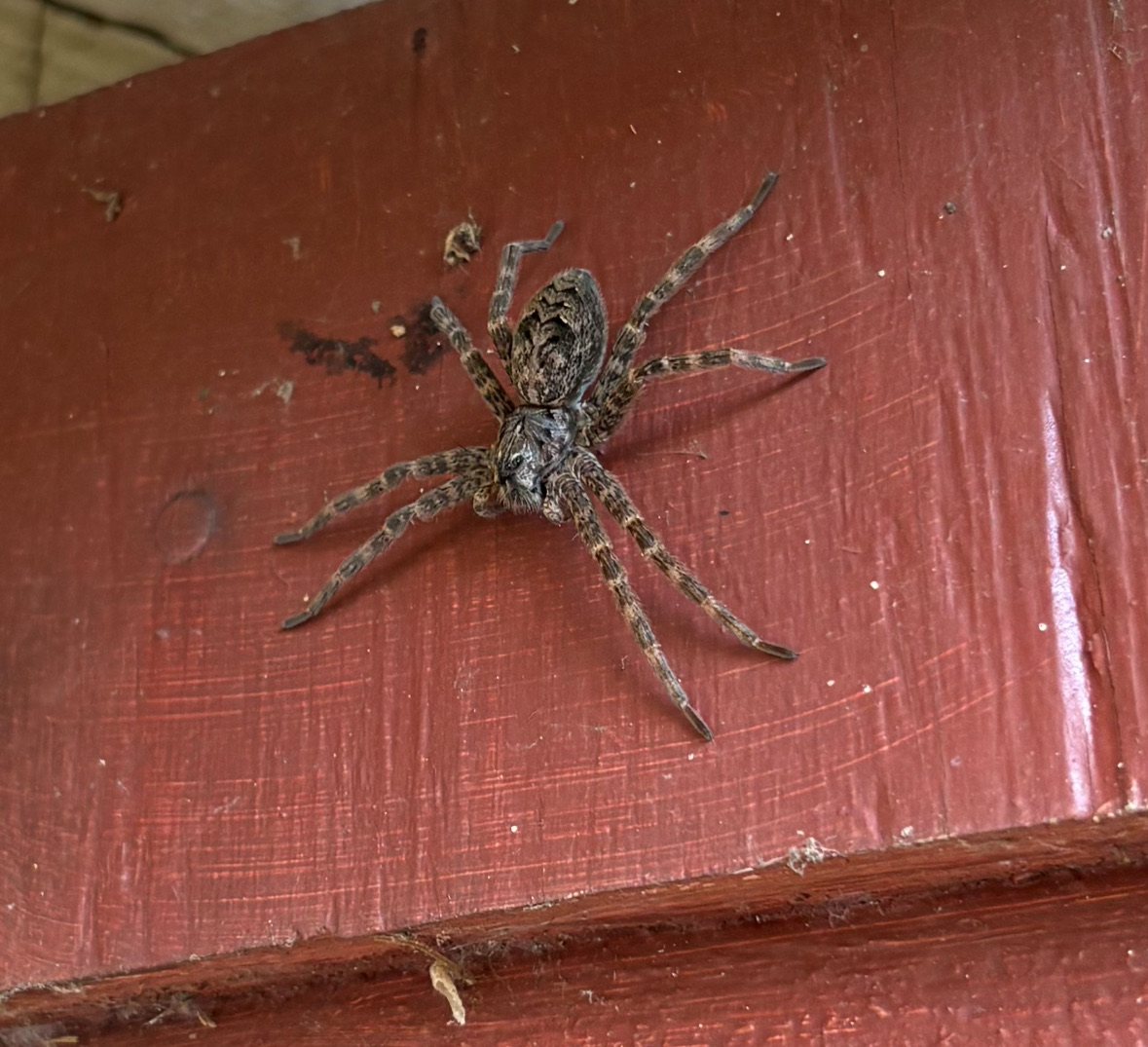
2 minutes ago, DavisStraight said:
You're right about that. Thank God mine was in the shed.
I mean what could be worse than spiders that give birth to live young? Even Alligators and Crocodiles hatch from eggs I am pretty sure.
-
3 minutes ago, weatherwiz said:
Friend of mine said fishing spider
No. That's a catching spider. It just catches and kills. No fishing required.
-
 1
1
-
-
1 minute ago, Damage In Tolland said:
It was a beast . If I had missed it (and it almost escaped) life would never be normal again here . Trust me
I believe you dude. Its climate change . They're coming up from the mid Atlantic and NYC area where they're really common in rural areas.
-
 1
1
-
-
Just now, Damage In Tolland said:
Ours turned into dead spider
I think those are the kind that if you kill them pregnant millions of little alive spiders come out and run all over the house.
-
1
-
 1
1
-
-
41 minutes ago, Damage In Tolland said:
Had that exact one in family room yesterday and unfortunately my wife saw it early morning and the scream is something I will never recover from. I grabbed a fly swatter and got hit with” Do not use that, that doesn’t even kill the flies” and then “grab a sneaker”.. So hence I grabbed a sneaker and went for the smash. I came in very slow until the smash and it still sensed me.. and tried crawling , but I hit it just as it made its move . She then said she’d never sit in that room again and vehemently declared it was a Black widow .
Omg in the house!! No No No. Your poor wife. I cannot even imagine the terror.
-
57 minutes ago, HIPPYVALLEY said:
Mother of God, where is that thing? This is where I would order like a million big centipedes.
-
On 4/19/2025 at 9:04 PM, CT Valley Snowman said:
BDL hit 89 as well.
Yeah I guess it was legit. After the downpours it went down to 65 but spiked back into the low 70s before falling off overnight
-
I think the 89 at cef is suspicious....only feels like 83-84 outside
-
1
-
-
Yesterday's wind was impressive in the afternoon but just a few sprinkles with it. Nice cool breezy morning. Gotta cherish them before they're gone. You guys had two nice days this week so no one should be unhappy. Tomorrow and beyond look pretty darn good too...what a difference a week makes!
-
1
-


July 2025 Obs/Disco ... possible historic month for heat
in New England
Posted
These dews are insane
I hope he's happy up there on the mountain. Doesn't really need to be much more than 80 when the dews are this high