D-Money
-
Posts
383 -
Joined
-
Last visited
Content Type
Profiles
Blogs
Forums
American Weather
Media Demo
Store
Gallery
Everything posted by D-Money
-
18z Euro looked paltry. Area wide dusting, Richmond just over an inch Kuchera 18z GFS has something for RVA
-
Hey! Stop by sometimes! Especially with us during storms specific to the tidewater. The southern forum is great, but no one there cares about our area. Would be awesome to have you posting here again.
-
Since we lost Fridays 6z Nam nuke this was going to be a non event. Can’t expect accumulations with temps 34-35 degrees and above freezing ground. Nonetheless was a decent one to track.
-
The death band alone was probably 2 inches if we had freezing temps and surfaces.
-
I think that nap turned things around
-
Unless there is another band or heavy precip, that should be it with accumulations. Nice dusting here which beat my expectations of white rain.
-
Big time rates under this band.
-
Mixing here
-
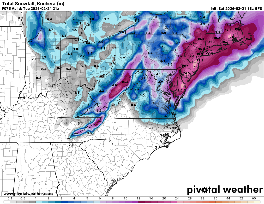
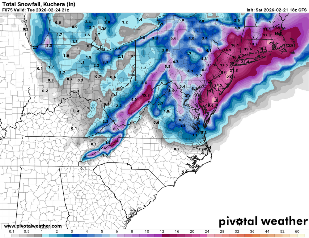
GFS
-
Latest HRRR
-
There is a report of rain/snow in Newport News.
-
mPing app for those that want to see what people are reporting. https://mping.nssl.noaa.gov Radar looks good https://weather.cod.edu/satrad/nexrad/index.php?parms=AKQ-N0Q-1-24-100-usa-rad
-
NAMs pushed accumulations north. looks like an area wide mulch topper. they have the LP just moving NE instead of developing back some and tucking in.
-
NAM 3k Kurchera
-
18z NAM Kuchera
-
Thanks! I did feel the need to step in ever since @RIC Airport relocated. Even recovered my account here. @Coach McGuirk where you at!
-
It’s going to come done to rates and banding. You’ll want to see silver dollar parachutes dumping. Then it’s just pile on city. Obviously soil temps are bad and we are hoping to be 32-33 degrees when it’s puking. But the chance for busting is high - moderate rates/34 F. Hoping for some surprising outcomes.
-
Looking forward to seeing the storm totals up there. Will be impressive. nexrad is one of my favorite radars. It’s dumping on southern NJ. https://weather.cod.edu/satrad/nexrad/index.php?parms=DOX-N0Q-1-24-100-usa-rad
-
Good to hear, thanks for the report. Radar is starting to blossom and fill in over RVA.
-
Latest HRRR sim radar there is only a couple hours of decent snow for RVA. p-type DGZ The DGZ is a favored thermal range within the cloud-bearing layer for ice crystal or dendritic growth. The depth of the DGZ is calculated as the total depth of the thermal profile that falls within this -12°C to -17°C range.
-
HRRR
-
GFS
-
GFS surface temps
-
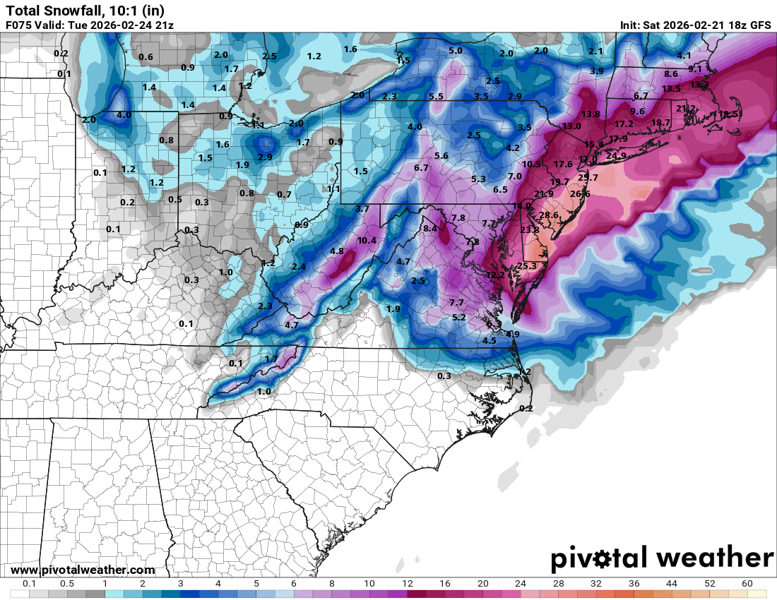
10:1 kuchera
-
GFS