

MoWeatherguy
-
Posts
2,322 -
Joined
-
Last visited
Content Type
Profiles
Blogs
Forums
American Weather
Media Demo
Store
Gallery
Everything posted by MoWeatherguy
-
MO/KS/AR/OK 2021-2022 Winter Discussion
MoWeatherguy replied to JoMo's topic in Central/Western States
Yes, Euro looking solid for even us in far NWA. -
MO/KS/AR/OK 2021-2022 Winter Discussion
MoWeatherguy replied to JoMo's topic in Central/Western States
If this is anywhere close to right then locations below freezing will have a helluva storm.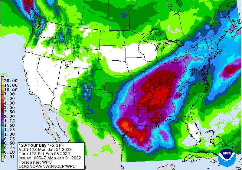
-
MO/KS/AR/OK 2021-2022 Winter Discussion
MoWeatherguy replied to JoMo's topic in Central/Western States
Interesting times ahead this week, guys and gals. -
MO/KS/AR/OK 2021-2022 Winter Discussion
MoWeatherguy replied to JoMo's topic in Central/Western States
All hope is not lost. We still have the Ukie painting out a widespread 6-8 across this entire area. This is probably a useless model tho. -
MO/KS/AR/OK 2021-2022 Winter Discussion
MoWeatherguy replied to JoMo's topic in Central/Western States
The current solutions are far from locked in. Jog back SE in the next 24 hours wouldn't surprise me. Just my opinion. Seen this dog and pony show too many times. -
MO/KS/AR/OK 2021-2022 Winter Discussion
MoWeatherguy replied to JoMo's topic in Central/Western States
Model jerking, guys. This is far from locked in. More than likely we all get a bit of everything. -
MO/KS/AR/OK 2021-2022 Winter Discussion
MoWeatherguy replied to JoMo's topic in Central/Western States
Sharp cutoff in AR, though. -
MO/KS/AR/OK 2021-2022 Winter Discussion
MoWeatherguy replied to JoMo's topic in Central/Western States
I'll take a double order of Euro, pls. -
MO/KS/AR/OK 2021-2022 Winter Discussion
MoWeatherguy replied to JoMo's topic in Central/Western States
Hoping that second wave late Wed early Thurs is the bigger of the two. -
MO/KS/AR/OK 2021-2022 Winter Discussion
MoWeatherguy replied to JoMo's topic in Central/Western States
I'm thinking more of a sleet fest for us down here, Waterboy. Hope I'm wrong. -
MO/KS/AR/OK 2021-2022 Winter Discussion
MoWeatherguy replied to JoMo's topic in Central/Western States
Changed over to light snow in Bella Vista. Nice to see. -
MO/KS/AR/OK 2021-2022 Winter Discussion
MoWeatherguy replied to JoMo's topic in Central/Western States
Close to 3" here. The back end gave us some heavy shower activity the past couple hours. -
MO/KS/AR/OK 2021-2022 Winter Discussion
MoWeatherguy replied to JoMo's topic in Central/Western States
I was thinking you must have gotten under one of those meso-scale bands that could certainly do that. We're probably close to 2" here. -
MO/KS/AR/OK 2021-2022 Winter Discussion
MoWeatherguy replied to JoMo's topic in Central/Western States
Looks like a lot of dry air eroding away the NW wrap around. I think the short term models are onto something with just some very light snow possible. I sure can't see another 2" or so but hope I'm wrong. -
MO/KS/AR/OK 2021-2022 Winter Discussion
MoWeatherguy replied to JoMo's topic in Central/Western States
I'm wondering now looking at short term models if we even get much of the afternoon round. This may be it for us. -
MO/KS/AR/OK 2021-2022 Winter Discussion
MoWeatherguy replied to JoMo's topic in Central/Western States
Wow, there's not even 2" here. -
MO/KS/AR/OK 2021-2022 Winter Discussion
MoWeatherguy replied to JoMo's topic in Central/Western States
Ok thank you. -
MO/KS/AR/OK 2021-2022 Winter Discussion
MoWeatherguy replied to JoMo's topic in Central/Western States
Question on the Pivotal snow maps - how do you get the inches overlay to show on there? -
MO/KS/AR/OK 2021-2022 Winter Discussion
MoWeatherguy replied to JoMo's topic in Central/Western States
Yes lol. I'm sure they're going bonkers -
MO/KS/AR/OK 2021-2022 Winter Discussion
MoWeatherguy replied to JoMo's topic in Central/Western States
One of the encouraging things on the 3k is the snow depth map, which takes away the snow that allegedly doesn't stick. Even it now has totals around 4-6 inches.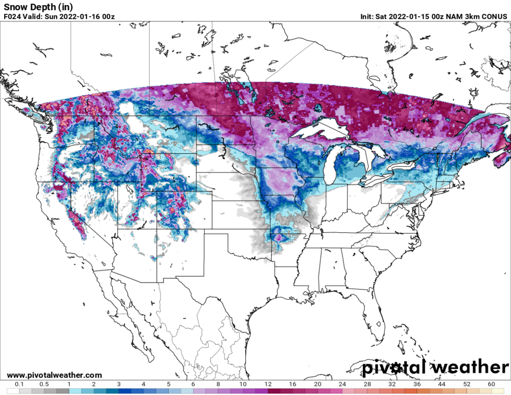
-
MO/KS/AR/OK 2021-2022 Winter Discussion
MoWeatherguy replied to JoMo's topic in Central/Western States
Beat me to it -
MO/KS/AR/OK 2021-2022 Winter Discussion
MoWeatherguy replied to JoMo's topic in Central/Western States
That 3k NAM very generous. -
MO/KS/AR/OK 2021-2022 Winter Discussion
MoWeatherguy replied to JoMo's topic in Central/Western States
Yes, west side close to the Highlands. -
MO/KS/AR/OK 2021-2022 Winter Discussion
MoWeatherguy replied to JoMo's topic in Central/Western States
Waterboy, are you in Rogers/Bentonville? -
MO/KS/AR/OK 2021-2022 Winter Discussion
MoWeatherguy replied to JoMo's topic in Central/Western States
Sorry yah I just found my website. Looking good.


