burrel2
-
Posts
2,388 -
Joined
-
Last visited
Content Type
Profiles
Blogs
Forums
American Weather
Media Demo
Store
Gallery
Everything posted by burrel2
-
eyore is a fictional character in the Winnie-the-Pooh books by A. A. Milne. He is generally characterized as a pessimistic, gloomy, depressed, anhedonic, old grey stuffed donkey sums up eyewalls general demeanor every winter, lol
-
You're going to Eeyore your way in to a big snowstorm and I can already see it coming. lol
-
Ok man, 34/21 equals a wetbulb of 32? Eyewall.... (Surface wetbulb temp of 29 degrees with snow moving in...)"That's basically just barely freezing.... NEXT!!!!!)
-
wow... a whooping 13 of 20 GEFS members show a significant winter storm for Charlotte, NC on COD weather model page. That is the best ensemble run to date for this storm. 5 of the 13 hits are mostly snow!
-
12z cmc is a completely whiff nothing burger. the shortwave is sheared out and weak... no precip for anyone really.
-
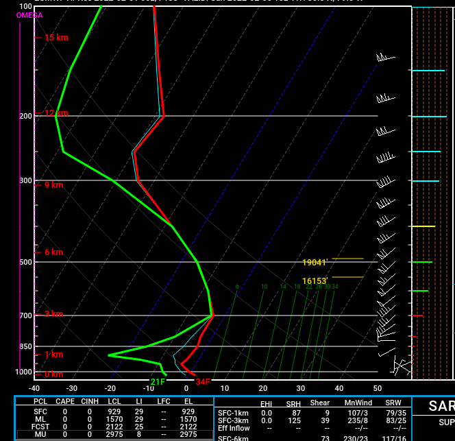
Here's the sounding for Raleigh Sunday at 1pm as precip is pivoting just to your south on the 00z Euro. Does that look like too warm/ice to rain scenario?
-
I mean sure if you take the GFS verbatim then I guess so. If you take the euro verbatim then South and East of the triangle gets all snow and more than Raleigh.... temps aren't an issue at all on the Euro. Point being, we don't know what's happening yet, anything is still on the table.
-
Well that was interesting... big step towards the Euro with regard to thermal profile on the GFS... still the most amped solution but it was very, very close to an all snow sounding for the whole storm in the upstate with over an inch of liquid. Storm trended way faster on the GFS so not as much time for CAD to build in, but also less time for WAA and scouring of the mid-level cold air so we get more snow for many. Overall a great run though b/c it trended towards the very cold and favorable Euro profiles...
-
Then there was this event in mid-february; a weak miller A; no strong dynamics involved. https://www.weather.gov/cae/Feb12_Snowfall_Event.html#:~:text=The average total snowfall across,and East Central GA...
-
I mean I get what you're saying, but it's really just not true. Take this event on February 16th, 2015.... it was a weak in-situ cold air damming event that nobody was really following because it was so marginal. All the global models showed me with a cold 35-38 degree rain. When hi-res models came in to play they were showing a 32/33 rain event for me, yet I got an awesome winter storm out of it. Here are my storm notes below... February 16, 2015 1 inch of sleet 1/10th inch of ice huge bust in our favor, models at 31/32 temp and freezing rain to rain, got 90% sleet and just a little freezing rain, wetbulbed to around 27 and temp was still 31 as final band came through
-
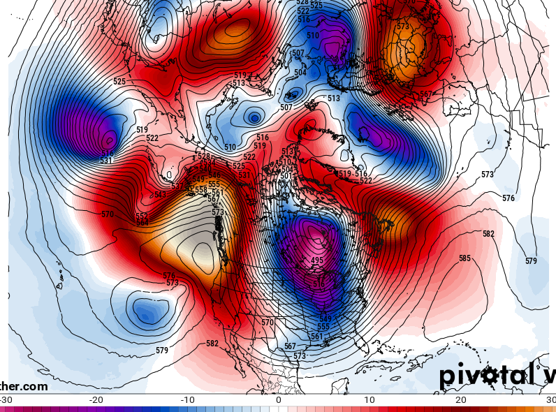
Also, the 6z GFS is pretty much showing wall to wall cold. Here's the 240hr 5h anamolies.
-
FWIW, the 12z NAM looks really good to me. Cold press is stronger like the Euro, the energy that hangs back in texas isn't phasing in with any baja junk like the CMC showed... it's consolidating in north central texas and looks poised to roll east.. not too strong but not too weak looking.
-
I guess i'm more of an optimist but we have a legit threat inside of 6 days right now. If you're going to discount and look past marginal threats then you're going to miss out on tracking 8 out of 10 snow falls in the southeast. This threat may not work out, but it's 100% better than having no threat to follow... and every so often these threats do work out and we get a season saving 3 incher out of it.
-
February 6th is mid-February?
-
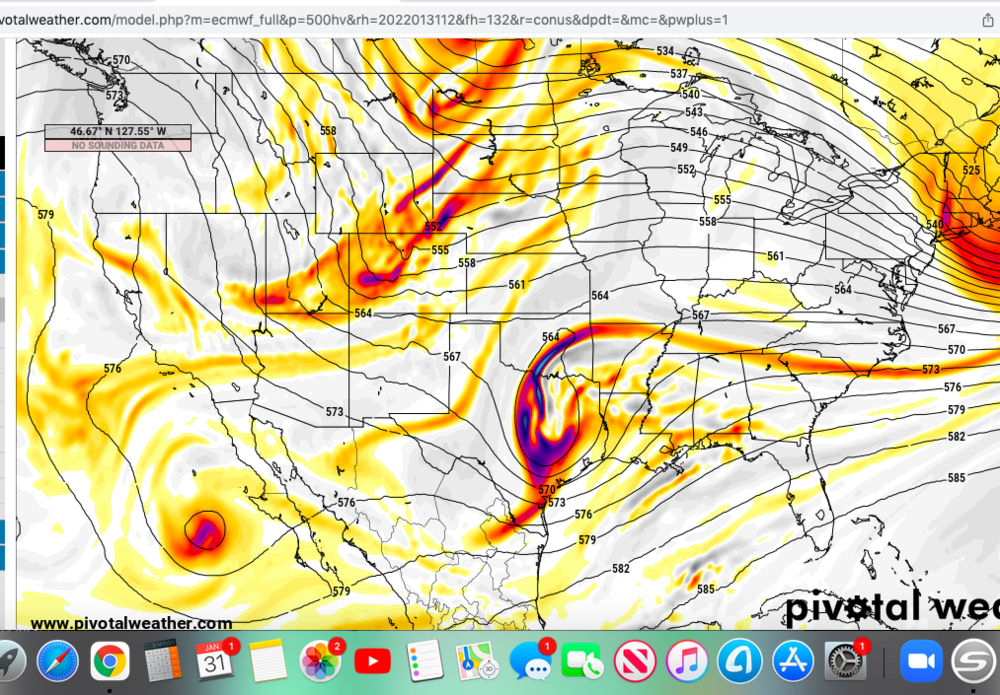
Alright, i've looked at all the data and I think I know what we need to happen for the best outcome... lol. It's hard to piece together because there's so many moving parts but here's my theory: The GFS and last night's ukmet are leaving both lobes of the shortwave behind when the first front comes through Friday. As a result, the front doesn't push as far south so our mid level cold air is more marginal. By leaving both lobes behind, they cut off in tandem with each other and swing around to create a longer trough as they get pushed our way. You wind up with one lobe in oklahoma and the other lobe swinging under it making a stronger neutral tilted trough. This allows for a stronger storm with more qpf farther north, but also more WAA. (This actually helps the wedging high pressure though b/c of more confluence in front of the trough.) That's why you see more ice on the GFS and basically no chance of snow for anyone. The Euro/ICON/NAM all allow the front lobe of our shortwave to get caught in the frontal system on friday. They're doing this b/c the shortwave dropping through minnesota is stronger and further south I think. As a result, there is a much better cold air press that comes our way behind the front. The remaining lobe cuts off in western texas and is weaker than the GFS shows b/c it's not both pieces working in tandem anymore. This lobe still cuts off though and strengthens before rotating our way. But it's not as long/neutral tilted as the GFS and we wind up with a weaker system with much more cold air to work with. This seems like the best recipe for our snow chances. The CMC is in the euro camp with respect to the frontal lobe getting sucked in to the first front... but it is taking the back lobe and phasing it in a third piece of energy way back towards the baja area. As a result the cut off low develops farther west (arizona//mexico border), than the euro and it's so far west that by the time it rotates our way we've completely lost our high pressure. This is the only model doing this with respect to the third piece of energy so I suspect it's wrong. All of this doesn't even factor in the kicker shortwave trough dropping down from Canada behind our storm which is clearly affecting the rate of decay and how much precip our main shortwave throws back our way. (though it seems this feature doesn't have as much effect b/c despite being modeled wildly different the storm outcome isn't effected too much amongst modeling from the changes). So all that being said... we need an outcome similar to what last night's euro showed, and the only improvements on that outcome being a slightly more consolidated/stronger cutoff/5h low (but not at the expense of holding back the frontal lobe portion early on) to allow for a little more precip as it swings through. That has the potential to drop 3-5 inches of snow for a wide swath of people on our board I think.
-
Cold air is marginal on the GFS, isn't marginal on Euro.
-
Call me a weenie but thr 84hr nam and rgem look a lot like the euro at 500mb. They all are stronger with the cold push and only keep a small piece of of energy back towards southern Utah. the gfs wants to hangs more energy back in Texas and has a stronger trough as a result and has less of a cold push out in front.(seemingly because it keeps more energy held back)
-
ukmet is an amped rainstorm... hmm
-
No reason to be pessimistic on the thermal profiles right now. CMC, ukmet, Euro, ICON are all much colder than the GFS.
-
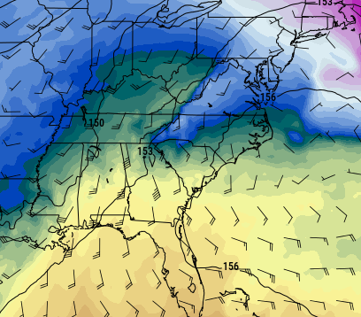
Just slight differences between the GFS and Euro with respect to the cold air push... This is valid for 7am Sunday morning; euro on top.
-
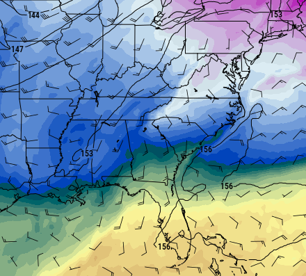
It's dropping 2 inches of liquid in central GA/SC. It's a great run considering the majority of guidance is on the suppressed side of things.
-
Eps looks super flat. Gonna need to hold on to the amped gfs on future runs as long as possible. The way this winter has gone we def need to root for more amperage; not less.
-
I bet the Euro Ensemble members will have some big dogs.
-
That's part of the balance for sure, but the other part is the initial cold press... if we get more cold dry air in the mid-layers out in front of the storm it leaves more margin for amplification yet still cold enough to snow. It's probably not realistic to expect an all snow event if we get a decent system, but if we get a good cold/dry push out in front, we could really perform well on the front end thump similar to the big snow/sleet storm back in January. We will get the benefit of the adiabatic cooling in the 850-900mb levels from Southeast flow in to the mountains.
-
Euro is so much better with the initial cold press... we would be talking good ratio's if it verifies. All we need is the Euro cold press and then the shortwave to hold together a little bit better and elongate/tilt a little harder as it swings through and you'd be talking a solid 3-6 inch powder dump for lots on this board. Also is it out of the realm of possibility to get that 2nd shortwave dropping down from Colorado close to phasing in on the backside of our main shortwave? I haven't seen any models show this yet, but dang it sure looks like the 12z euro was close... if those hooked up it could really get interesting.